Economic globalization has reshaped the world economy's spatial pattern while simultaneously changing the context for developing economic geography theories. This study revisited the changing features of economic globalization and investigated its geographical implications. Next, it summarized the new trends in economic geography studies in response to the changing economic globalization. Lastly, this study proposed a research agenda for domestic economic geography studies by combining the requirements of global trends and national strategies. The main findings include the following: The scale of geographical integration during economic globalization keeps shrinking, leading to a pattern of regionalization. The driving forces of economic globalization have gradually shifted from cost-saving to innovation. Accordingly, the benefits of economic globalization will be reallocated between developed and developing countries. The trade-offs between efficiency and resilience alter the global value chain, shifting outsourcing from off-shoring to re-shoring or near-shoring. The changing economic globalization has witnessed the rising effects of geographical distances, institutions, and resilience on increasing the inequality of the global economic geography. In economic geography, the scalar structures shifted from the global-local to the global-national-local. The relational networks evolved toward a multi-level, multi-agent, and multi-scale one. The role of the nation has been revisited. More attention has been paid to geopolitical hotspots. Overall, economic geography's institutional, cultural, relational, and evolutionary turns exhibit an emerging trend to convergence. In such a setting, domestic economic geography should find a new balance between global trends and national strategies. This study proposed seven research issues, including: (1) the practice of the Belt and Road and the pattern of inclusive globalization; (2) the economic geography of dual circulation; (3) the paths and resilience of regional development in response to the global production network restructuring; (4) the evolution and competitiveness of industrial clusters; (5) the building of multi-level innovation systems; (6) the regional sustainable development within the global environmental governance system; and (7) the impact of geo-economics on national economic security and interests.
New materialism is an academic trend that emerged in the 1990s, along with "object-oriented philosophy" and "return to material objects" research, which advocates a new perspective for understanding human-land relations and social and cultural practices based on broad symmetry and ontological reconstruction. Facing the challenge of today's multimaterial world and the demand for continuous optimization of cultural research, new materialism has become a new concept for cultural narratives advocating the coexistence of all things in the world. At present, research on new materialism in the field of geography mainly focuses on introducing and reviewing academic progress in this area, while research on its connotations, development, evolution, and other aspects is not systematic enough. Some members of the academic community believe that new materialism denies the laws of human social and historical development and represents an ideological trend toward anthropocentrism and idealism. This inevitably leads to doubts and even confusion about the theoretical temperament of new materialism. In addition, some people worry that paying attention to object-oriented philosophy, as advocated by the new materialism, will lead to a repetition of the theoretical mistakes of earlier geographical/environmental determinism. How to understand the theoretical connotations of new materialism deeply, how to view the contemporary development of new materialism objectively, how to exert the value-added effect of new materialism reasonably, and how to guide research on and the practice of new materialism in cultural geography have become important scientific issues that need to be clarified in the academic community. This study examines the actual background to the emergence of new materialism and the problems of "matter/discourse" in poststructuralism as well as the theoretical foundations on which new materialism was established. In addition, the cognitive turn and research orientation of new materialism in cultural geography are examined, focusing on three aspects of reseach in cultural geography: tracking and experiencing the spatial and local operation of material; the interaction between material space and the production of social and cultural significance; and the co-creation by human and non-human beings of the geographical environment and ecological order. At the same time, in terms of the differences between the practical subject and its dynamic force, this paper responds to the question raised by the academic community about the relevance of new materialism and traditional historical materialism. Based on an analysis of the development and evolution of geographical/environmental determinism, it is clarified that the new materialism paradigm in cultural geography does not represent a return to traditional theory but rather a transcendence of the times. New materialism will continue to improve and become more mature. This study highlights the fact that China is currently seeing a great deal of research and practice requiring the involvement of new materialism. Properly understanding and absorbing the reasonable elements of the theory of new materialism is beneficial for bridging the gap between natural and human geography and is also conducive to innovation and promotion of the rapid development of cultural geography and even geography in China.
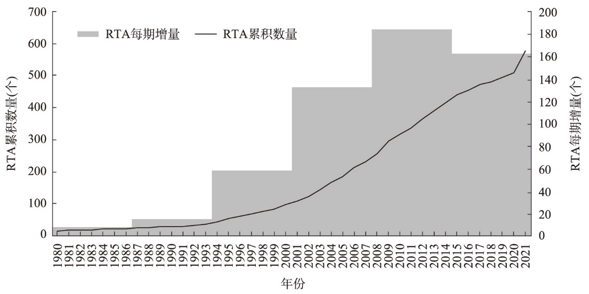
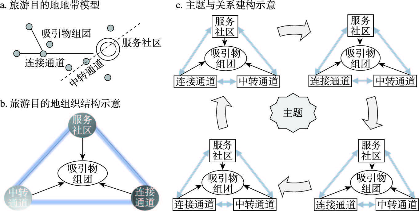
Tourism destination is the core concept of tourism geography. With deepening development of globalization, informatization, and network interaction, profound change has occurred in the spatial form, scale, and relationship of tourism destinations. Route tourism destinations have become an important product of modern tourism and a new spatial form of tourism consumption. Therefore, based on the relationalism perspective of post-structuralism, this study developed a conceptual framework and research system of route tourism destinations, and is intended to provide theoretical support and practical reference for related research. It is believed that the spatial organization and the spatial scale of tourism resource elements have undergone profound changes, and that the characteristics of the era of mobility require us to dismiss the traditional static and structured destination cognition system, and reconsider tourism resources under the background of modernization. The new cognitive system and multiscale analysis framework will improve on the existing cognitive structure of the tourist destination. Route tourism reflects a community organization and spatial continuum of relevance, fluidity, and dynamics formed by interaction in a specific direction with certain themes of nature, culture, and transportation as the relevant axes. Moreover, route tourism is the result of the linkage and spatial association of various tourism elements such as resources, services, infrastructure, and stakeholders. The theoretical perspective of post-structuralism provides a basis for the study of route tourism destinations, and relational linkage and relational space have robust theoretical applicability in the development and evolution of the organizational structure and spatial structure of route tourism destinations. The evolution of the process, mechanism, and multiscale research of route tourism from the perspective of post-structuralism theory provides a reference plan for further theoretical and practical development, and for expansion of new perspectives and new fields of tourism destination research.
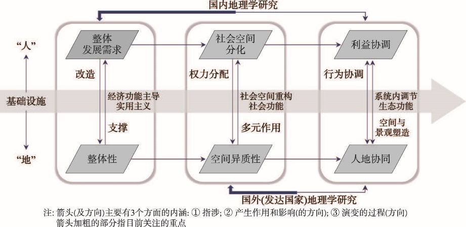
Infrastructure construction reflects the interaction between "human" and "land" in the process of transforming and utilizing the natural environment, whose implementation process involves complex interactions between human and land. With the continuous advancement of China's Belt and Road Initiative, the significantly increased cross-border infrastructure activities on different scales, such as the global, regional, national, and urban, as well as the complex interactions between human and land involved in their implementations, have triggered collisions and conflicts between Chinese and foreign scholars on the geography of infrastructure construction. This paper systematically compares the concerns and research contexts of Chinese and foreign geographic research on infrastructure-related issues, and on this basis, it reflects the key issues of infrastructure research based on the perspective of geography. It believes that infrastructure construction reflects the various purposes and methods of how nature is transformed and utilized by human beings. At present, domestic geographical studies have focused on the economic function of infrastructure construction, while international geographical studies have paid more attention to the heterogeneity of the "human" and "land" involved in infrastructure's concern on human-land relationship. This paper insists that this academic boundary is caused by different demands of the various social development stages on infrastructure, and it is essentially a continuous process. On the basis of comparing the differences in infrastructure studies between domestic and international geography, this paper discusses how the infrastructure corrects and regulates human-land relationships from a more dynamic, multidimensional, systematic, and relational ontology perspective, and then explores the core geographical issues involved in infrastructure under the background of this new and systematic infrastructure ontology. From a theoretical perspective, this paper integrates the ontological differences in infrastructure studies within and outside China and constructs a unified conceptual framework and ontological foundation for effective dialogue between domestic and international geographical studies. From the practical perspective, under the background of "Infrastructure Going First" in China's "Going Globally" strategy, this paper also has important reference value for China's overseas infrastructure construction.
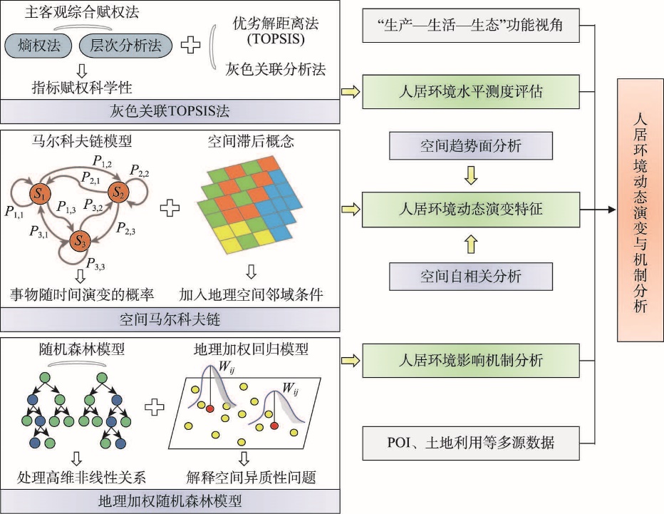
The construction of urban human settlements is an important content to promote the high-quality development of the Yellow River Basin, and it is also a comprehensive way to realize the coordination of human-earth relations in the watershed. This paper constructs an urban human settlements evaluation index system based on the perspective of "production-living-ecological" function, and comprehensively uses the Grey Relation Analysis-Technique for Order Preference By Similarity To Ideal Solution (GRA-TOPSIS) method, spatial Markov chain, Geographically weighted Random Forest (GWRF) and other methods to analyze the dynamic evolution and influencing mechanism of urban human settlements in the Yellow River Basin (YRB) from 2011 to 2020. The results show that: (1) The urban human settlements in the YRB generally exhibits the positive spatial distribution characteristics of "high in the east and low in the west, high in the south and low in the north", forming a high-value area of the human settlements dominated by Xi'an, Zhengzhou, Qingdao and Jinan, and a low-value area of the urban human settlements dominated by cities of Tongchuan, Zhongwei and Jiayuguan. (2) The dynamic evolution of the urban human settlements in the YRB has significant spatial interaction and dynamic transfer convergence. There is a certain degree of "self-locking" effect of the transfer path at the level of the human settlements. The level of the human settlements usually only transfers between adjacent levels, and the probability of cross-level transfer is small. (3) The human settlements are the result of the comprehensive effects of economic level, environmental quality and social resources. The economic level dominates, while consumption level, air quality, and transportation resources are the main factors that affect the level of urban human settlements. (4) GWRF model can effectively explain the spatial heterogeneity characteristics of influencing factors in the local geographic space. It is expected to become a more effective explanatory tool in the field of human settlements research. This paper deepens the theoretical methods of human settlements research and provides a scientific reference for promoting the construction and high-quality development of the human settlements in the YRB.
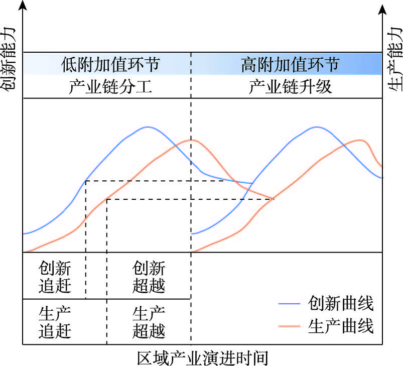
The integration of production chain and innovation chain is the key to enhancing industrial competitiveness and promoting high-quality development. However, the integration has sectoral and spatial configuration, which shows different coupling patterns in different production sectors and locations. With the deepening of industrial divisions, the sectoral and spatial differences increase. The electronic computer industry, a typical knowledge and technology intensive industry with the long production chain and huge innovation outputs, is the best object for studying the integration of production and innovation chains. In order to understand the evolution path and spatial integration pattern of industrial production and innovation, this paper takes the Pearl River Delta (PRD) as the research study, analyzes the spatial pattern and evolution characteristics of production centers and innovation centers in different sectors from 2010 to 2020 by the means of location quotient and weighted average based on the patent application data and enterprise data. The results show that the electronic computer industry in the PRD has formed a clear industrial division in production and innovation. Late-developing edge cities such as Zhaoqing and Jiangmen have strong innovation advantages in the upstream sectors of industry, but their production advantages are weak. Dongguan, Guangzhou and other core cities have strong production advantages and innovation advantages in the middle and lower reaches of industry. Economic globalization promoted the horizontal and vertical division of electronic computer industry, which makes late-developing edge cities such as Zhaoqing and Jiangmen gain international and domestic technical diffusion and become innovation centers in upstream sectors with low technical threshold such as electronic components through technical catch-up. However, due to location stickiness and path dependence, the production centers of upstream sectors are still concentrated in early-developed cities such as Dongguan and Foshan. As for the downstream sectors such as Internet of Things technology and software, their innovation and production centers are normally concentrated in the core cities such as Guangzhou and Shenzhen with larger market size and higher activation. As an empirical study, this paper discusses the mechanism of spatial dynamic change of electronic computer industry chain in the PRD under the background of industrial division and upgrading, which is of great significance to the high-quality development and competitiveness improvement of local and national computer industry.
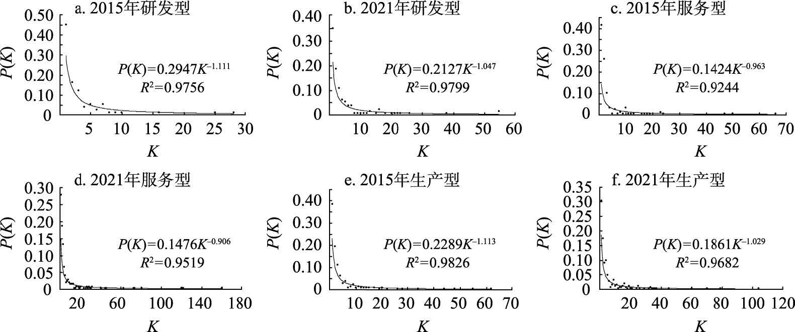
Based on the data of listed companies in the core industry chain of China's new energy vehicles in 2015 and 2021, this paper constructs their industrial network from the perspective of the value chain, and uses methods such as social network and negative binomial regression model to study the characteristics, evolution, differences, and formation mechanisms of different value chain networks. The results show that: (1) R&D-oriented, production-oriented, and service-oriented networks share several common features: These networks are simultaneously expanding in scale and transitioning towards more efficient "small world" network; The degree distribution in these networks follows a power-law distribution, indicating a scale-free network structure; There is a decrease in the power-law exponent of network's degree distribution, indicating an increase in network heterogeneity. Furthermore, there is a significant positive correlation between the degrees of nodes in networks with diverse value chains, suggesting that the same node holds a similar level of significance across different networks. (2) The number of power-prestige, power and prestige nodes increases in the networks of all value chain segments, except in the service-oriented network, where there are no power nodes. In each value chain network, these nodes have different agglomeration directions. In R&D-oriented network, the nodes tend to cluster around headquarters and high-level cities. In contrast, service-oriented network shows a concentration of nodes in municipalities, sub-provincial and provincial capitals. Similarly, production-oriented network demonstrates a clustering of nodes in traditional production bases. (3) Different value-added segments of industry form different types of agglomeration in pursuit of different factor endowments and agglomeration effect, and form the spatial structure of the strongest connection industrial network with different characteristics. The R&D-oriented networks have always been an integrated and closely connected multiple core-periphery structure community with the influence of social, technological and geographical proximities; transformation of service-oriented network from an integrated and closely connected multiple core-periphery structure community to a multiple core-semi-periphery-periphery structure community with the influence of social, geographical and institutional proximities; transformation of production-oriented network from the partially integrated and localized core-periphery structure community to the more decentralized multiple independent core-periphery structure community with the influence of the social, institutional and administrative boundaries and geographical proximities.
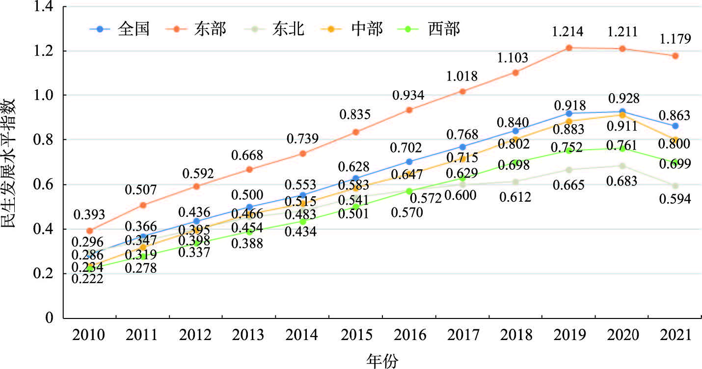
In the new era, the law of spatial evolution for the development of people's livelihood is of great theoretical and practical significance for fostering people's livelihood development and creating general prosperity in China. Based on the data from 2010 to 2021, we examined the spatial evolution and influence mechanism of the Chinese people's livelihood development level by using methods including the fixed base range entropy weight method, standard deviation ellipse, kernel density estimation, spatial Markov chain, and geographically and temporally weighted regression. The findings show that the Chinese people's livelihood development level has improved remarkably, with eastern region having the highest level, followed by central region, western region, and finally northeastern region; the people's livelihood development level in China is related to regional development to a certain extent, and the high-value and low-value clusters are concentrated, with the Yangtze River Delta and Beijing-Tianjin-Hebei region being stable hot spots, and Sichuan a stable cold spot. Additionally, the focus of the livelihood development has shifted from the northeast to the southwest, showing a gradual spatial trend, and the difference in the livelihood development among the four major regions is gradually increasing, with a trend of polarization between the country and the western region. Moreover, the shift in the focus of Chinese people's livelihood level has been affected by the neighboring provinces. Finally, the economic development, science and technology progress, aging population, and fiscal decentralization have positive effects, whereas urbanization has a negative effect on people's livelihood development, and the effects of these five factors exhibit spatial variations.
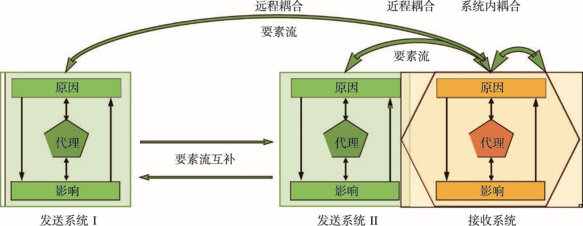
Introduction of the concept of metacoupling framework into the study of agricultural land use transition to carry out system integration in spatial dimensions is expected to achieve more accurate understanding on the "teleconnection" mechanism of urban-rural land systems. Therefore, on the basis of summarizing the study progress of agricultural land use transition and finding out the deficiencies in the research of land system "teleconnection", this paper demonstrates the scientific basis of the theoretical innovation from two aspects: the metacoupling framework and the linkage of food system. By taking food system as the linkage between rural and urban areas, as well as the linkage for integrating "flow space" and location space, we propose the theoretical framework for agricultural land use transition under the metacoupling framework of urban food system. This paper clarifies the concept and connotation of agricultural land use transition under the metacoupling framework of urban food system, the research path for explanation of agricultural land use transition and the content system of agricultural land use transition research. It is believed that the transition of agricultural land use under the metacoupling framework of urban food system is the results of the synergistic effects of the resource intrinsic power, the external driving force of essential factors, market allocation power and government regulatory power through the feedback path of urban production factors, the food shortage path in urban areas and the demand-driven path of urban-rural residents. In-depth analysis of agricultural land use transition under the metacoupling framework of urban food system requires adopting a geospatial network mode thinking, that is, it is necessary to integrate "flow space" and location space, making explanation of the agricultural land use transition of the case study area in connection with many other areas from the perspective of factor supply and demand and environment. This paper also introduces the five factor mobility effects that need to pay attention to in explanation of the agricultural land use transition, pointing out that several aspects should be focused on in research of agricultural land use transition under the metacoupling framework of urban food system, including the agricultural land use transition mechanism, the spatial differences and evolutionary patterns of agricultural land use forms within urban food domain, the response level of agricultural land use to demand changes and the influencing factors, and the regulation of agricultural land use transition, and so on. This paper is expected to open a new research field for agricultural land use transition and provide theoretical reference for addressing the issues concerning agriculture, rural areas and farmers in the new era.
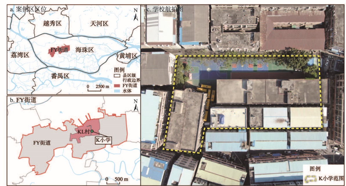
High-speed urbanization has brought the deep embedment and blending of urban spaces, and further resulted in the phenomenon of spatial friction and negotiation and even contradiction. Among them, the phenomenon and problems of spatial competition between schools, key actors and urban functional spaces have not been fully understood and studied. Taking a private primary school for migrant children in the largest urban village in Guangzhou as a case, this paper takes the theory of heterotopia as a starting point, discusses it through field investigation methods such as semi-structured interview and participatory observation, examines the spatial character of urban village schools, and interprets the production process of schools as heterotopia spaces. The findings are as follows: (1) The existence of schools in urban villages is different from that of other schools, which is understood as "an oasis in urban villages"; (2) In order to maintain the uniqueness and independence of educational space in the urban village, the school adopts various ways to maintain and strengthen its material and symbolic boundaries; (3) There is complicated spatial friction and negotiation between the school and the external urban spaces, but the school is in a marginal position in the local power structure. The research theoretically enriches the spatial knowledge of educational research, reveals the sociality and politics of schools as a heterotopia, and thus talks about the current heterotopia studies. At the same time, it is expected to deepen the academic understanding of the mechanism of the spatial dilemma of private schools in urban villages, arouse the concern of all sectors of society for private schools in urban villages, and create a better and fairer educational environment for migrant children in urban and rural areas.
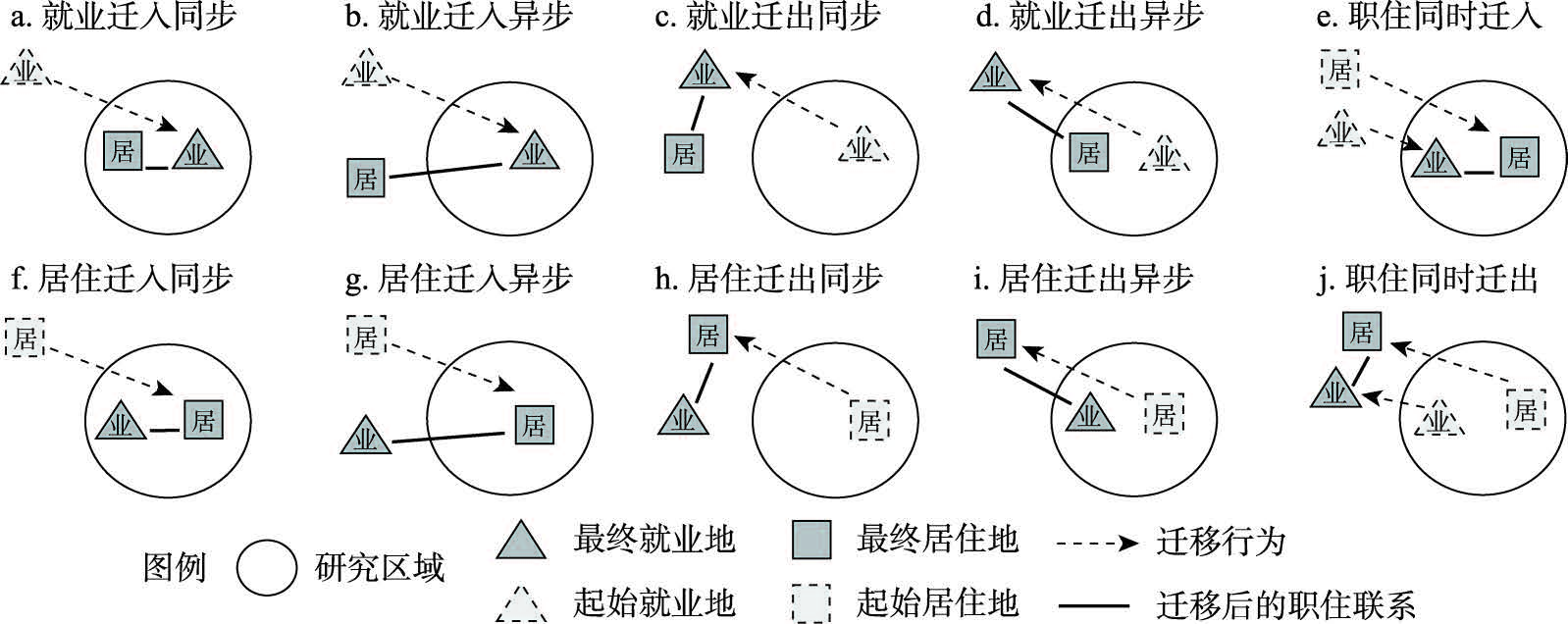
Suburban new cities often accompany the phenomenon of jobs-housing imbalance. From the behavioral perspective, against a backdrop of changes in jobs and housing, this is mainly caused by individual migration in and out during the long-term development of suburban new cities. However, many studies have not considered incorporating individual migration into the dynamic process of jobs-housing balance, and there are few relevant analysis methoeds, as well as unclear characteristics and patterns. This paper proposes the concept of jobs-housing dynamic balance by tracking the spatial changes of individual employment and residence migration. Drawing on cellular signaling data throughout 2017 to 2019 in Wuhan suburban new cities, a new analytic approach is developed to analyze the problems, causes and trends in the process of jobs-housing dynamic balance, including the synchronous and asynchronous indices of individual migration, as well as the impact index of dynamic jobs-housing balance. The results reveal that the main trend is asynchronous jobs-housing migration, with migration of a larger number of employers compared to residential migration. At the same time, the jobs-housing imbalance in Wuhan suburban new cities is relatively common, but individual migration generally promotes jobs-housing balance. On the one hand, individual migration in is the main factor in optimizing jobs-housing balance. On the other hand, the impact of individual migration out cannot be ignored, as it has driven the imbalance of jobs and housing in some suburban new cities. Furthermore, our results highlight that the jobs-housing balance in the southeast new city is more susceptible to the impact of residential migration, and residential migration is the main driving force for its jobs-housing dynamic balance. Therefore, it is necessary to focus on improving the diversified residential spatial structure. We argue that, grounded in the new analytic approach, this paper can objectively reflect the dynamic process and driving factors of jobs-housing balance, and our findings would be important in optimizing urban jobs-housing relationships and formulating policies for jobs-housing space supply.
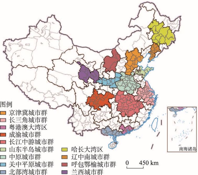
The cities covered by urban agglomerations are important spatial carriers of high-quality development. The relevant research on the convergence club of urban high-quality development is conducive to customizing high-quality development paths for different types of cities and promoting common prosperity among regions. This paper takes 174 cities in 13 urban agglomerations as the research objects, and constructs a high-quality development indicator system of cities from six aspects: economic development, social security, social equity, achievement sharing, environment quality and spatial connection. The traditional Markov chain and spatial Markov chain are used to analyze the spatiotemporal evolution of convergence clubs, and further examine its formation mechanism. The results show that: (1) The overall high- quality development index of cities within urban agglomeration is rising. In the optimization and upgrading stage, the cities in the urban agglomeration develops fastest and has the highest index; in the development and growth stage, the development of cities is slow and the polarization is obvious; the overall index of cities in the cultivation and development stage is low, showing a fluctuating upward trend. Environmental governance capacity, pollution emission level, growth stability, social stability, and traffic network accessibility have higher weights. (2) There is a phenomenon of convergence clubs in cities within urban agglomerations, and the low level convergence club is concentrated in the northeast and western inland areas; the middle and low level and middle level convergence clubs are mainly located in the urban agglomerations of the Central China Plains and the middle reaches of the Yangtze River; the middle and high level convergence club is distributed around high level convergence clubs; the high level convergence club is mostly composed of central cities of urban agglomerations and provincial capitals. (3) The local differences of factors such as industrial structure coordination, fiscal revenue, scientific and technological innovation, neighborhood effect and the internal linkages of urban agglomerations drive the formation of convergence clubs.
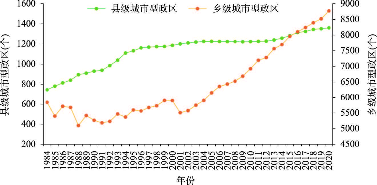
Blindly promoting county-district(city) conversion or township(town)-subdistrict office conversion is not conducive to optimizing the urban spatial structure and improving the efficiency of urban governance. Reasonable adjustment should be based on the matching of administrative divisions and urbanization process. On the basis of summarizing the phased changes of the adjustment of city-type administrative regions by using the administrative division setting data of provincial-level region in China published by the National Bureau of Statistics, this paper uses the urbanization management rate and urbanization management index to measure the adaptability between the establishment of city-type administrative regions and urbanization in China from 1984 to 2020. It is found that the matching degree between city-type administrative regions and urbanization at county level is significantly higher than that at township level, but the gap between county level and township level is narrowing continuously. There are significant differences in the adaptability between the establishment of city-type administrative regions and urbanization in different regions. Based on the above findings, according to the degree of deviation of the urbanization management rate and urbanization management index of each province from the national average level, as well as the difference of urbanization management level at county and township levels within the province, this paper proposes the priority of the future adjustment of city-type administrative regions, the focus of synchronous adjustment at county and township levels, and nine provincial-level administrative regions that need to be paid attention to. In order to improve the scientificalness, standardization and effectiveness of the establishment and adjustment of city-type administrative regions, it is necessary to strengthen top-level planning, fully consider regional differences and improve the rules and regulations for setting up city-type administrative regions.
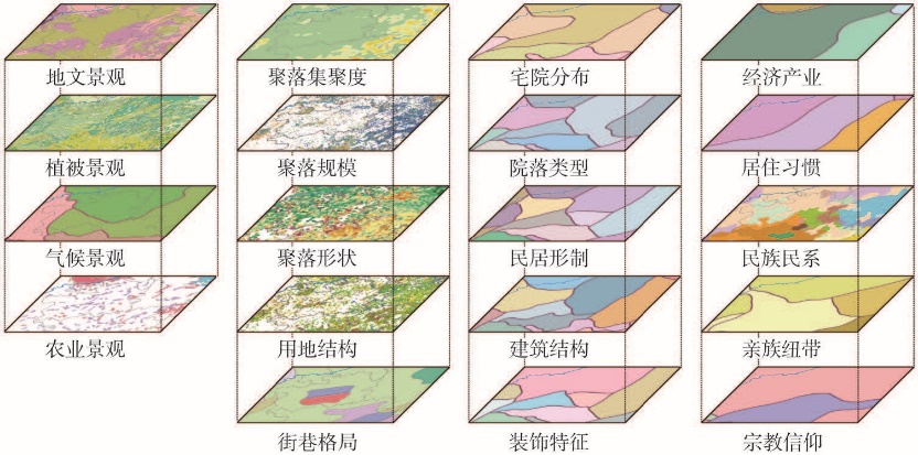
The long historical development process has shaped rural settlements in China with distinct regional characteristics that profoundly reflect the unique geographical environment, history, culture, and lifestyle of each region. Therefore, the comprehensive regionalization of Chinese rural settlement characteristics on the basis of the regional differentiation pattern of rural settlement characteristics is an fundamental research for preserving and transforming the characteristics of rural settlements with adaptation to local conditions. It is also one of the long-term topics in human geographical studies. This study constructs an index system for comprehensive regionalization from four aspects of rural settlement characteristics: earthscape, settlement, architecture, and culture. On the basis of systematic field research results and multisource data, a comprehensive evaluation of rural settlement characteristics is conducted, recognizing the regional differentiation pattern of Chinese rural settlement characteristics. On the basis of its results, a comprehensive regionalization of Chinese rural settlement characteristics is proposed using existing regionalization studies on physical geography, agricultural geography, cultural geography, landscape of rural settlements, and traditional dwellings as references. This regionalization is developed in accordance with the principles of regional conjugacy, synchronicity, coordination of comprehensiveness and dominant factors, and relative consistency. We use the qualitative and quantitative methods of category mapping, spatial cluster analysis, geographical correlation analysis, dominant factor analysis, and overlapping analysis. In the proposed regionalization, China is divided into 12 regions and 82 subregions in accordance with rural settlement characteristics. The 12 regions are as follows: (1) Northeast China, (2) North China, (3) the Loess Plateau, (4) East China, (5) Central China, (6) Fujian-Hakka, (7) Lingnan, (8) Sichuan-Guizhou, (9) Yunnan, (10) Northern Border, (11) Northwest China, and (12) the Tibetan Plateau. The characteristics of rural settlements in each region are also summarized. By comprehensively reflecting on the similarities and differences of the characteristics of Chinese rural settlements at different scales, the proposed regionalization is capable of providing scientific support to the regionalized and classified preservation of characteristic rural settlements.
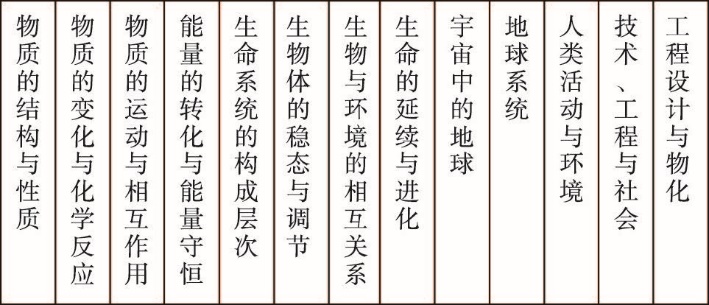
A member of the National Committee of the Chinese People's Political Consultative Conference (CPPCC) proposed changing middle school geography courses to earth science courses during the annual session of the CPPCC in 2023. Subsequently, relevant articles were published in China Science Daily, China Newsweek, and Science Park, sparking discussions and concerns in public about whether middle school geography courses should be changed to earth science. In order to answer this question, we conducted a survey on the curriculum settings of middle school geography and earth science in major representative countries or regions of the world through literature review, online search, and consultation with overseas friends. We also analyzed the role of geography discipline and middle school geography course from the perspectives of disciplinary nature, educational functions, geographical perspective, and serving major national needs. The results indicate that representative countries or regions around the world have generally offered middle school geography courses. Although some countries or regions have also established earth science courses or related content in middle schools, there has been no phenomenon or trend of renaming or changing middle school geography courses to earth science. Because of the intersectionality of humanities, natural sciences, and engineering technology, the uniqueness of geographical perspective, and the diversity of educational functions, geography is indispensable in secondary education. The middle school geography course is a synthesis of a major category of teaching content, and is synonymous with "heaven, earth, and man". Changing middle school geography course to earth science course can lead to confusion in the relationship between middle school courses and the destruction of the middle school curriculum system, leading to deviation or ambiguity in social cognition. In addition, the new geoscience discipline system characterized by earth systems science is in the process of forming and constantly improving, and there are still problems in methods, standards, strategies, analysis, etc., and the research on the earth is still limited to the planetary scale, not including the global, regional and local scales of geographical research, which is far from the actual needs of socioeconomic development. Therefore, middle school geography courses should not be replaced with earth science courses. Earth science education can be achieved through middle school science and geography courses.