
Remotely-sensed phenology pattern regionalization for land cover classification of natural scenes: A case study in China
Received date: 2023-11-14
Revised date: 2024-05-26
Online published: 2024-09-27
Supported by
National Key R&D Program of China(2021YFB3900501)
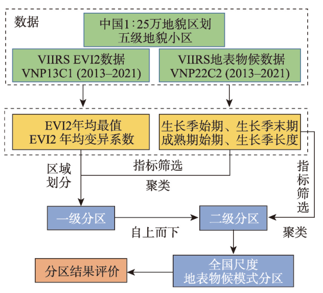
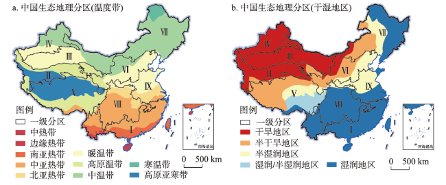
Selection of appropriate geographic boundaries for zoning the study area or images can effectively improve the accuracy and efficiency of land cover classification by reducing the complexity of land cover within the regions and the variability of its features in the images. At present, the regionalization data used in land cover mapping based on stratified classification strategies, such as ecological regionalization, lack targeted objectives, which limits its applicability and effectiveness in remote sensing classification. Vegetation phenology is the main cause of spectral heterogeneity within the land cover of natural scenes. To address this issue, this study proposed a remotely-sensed phenology pattern regionalization scheme for land cover classification of natural scenes. The regionalization scheme is implemented by constructing a zoning index system using vegetation indices, which reflect the greenness status of vegetation, and key phenological periods, which reflect the growth and development rhythm of vegetation. Small geomorphic regions are used as the zoning units, and a data-driven spatially constrained hierarchical clustering algorithm is employed in the regionalization. The evaluation results based on statistical tests and multi-source land cover products indicate that the remotely-sensed phenology pattern regionalization in this study effectively reduces the complexity of land cover within the region and the intra-class feature heterogeneity caused by vegetation phenology, and shows high potential in constructing representative land cover sample libraries and implementing stratified classification strategies.

Key words: phenology; regionalization; land cover; classification; remote sensing; China
LIU Xiaoliang , WANG Zhihua , YANG Xiaomei , CHENG Weiming , ZHANG Junyao , LIU Yueming , LIU Bin , MENG Dan , ZENG Xiaowei . Remotely-sensed phenology pattern regionalization for land cover classification of natural scenes: A case study in China[J]. Acta Geographica Sinica, 2024 , 79(9) : 2206 -2229 . DOI: 10.11821/dlxb202409004
表1 全球土地覆被产品及中国植物功能型产品主要参数Tab. 1 Key parameters of global land cover products and China's plant product of functional types |
表2 物候特征不显著区域划分准则Tab. 2 Criteria for delineation of regions with insignificant phenological characteristics |
| 区域类型 | 划分准则 | 区域特征描述 |
|---|---|---|
| 物候特征 不显著区域 | 以常绿型植被为主要土地覆被类型,植被绿度季节性变化不明显 | |
| 以稀疏植被或裸地为主要土地覆被类型,植被光谱特征微弱 |
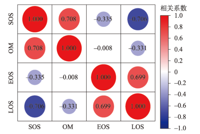
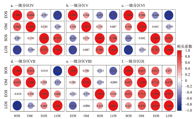
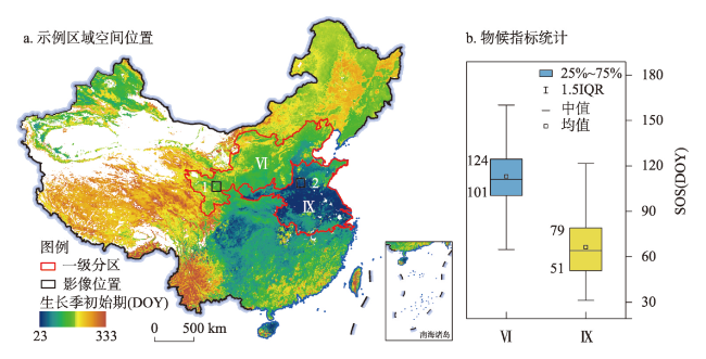
图7 植被物候特征显著一级分区内4个物候指标的斯皮尔曼相关性检验结果(p<0.05)Fig. 7 Results of Spearman's correlation test for four phenological indicators in the first-level regions with significant phenological characteristics (p<0.05) |
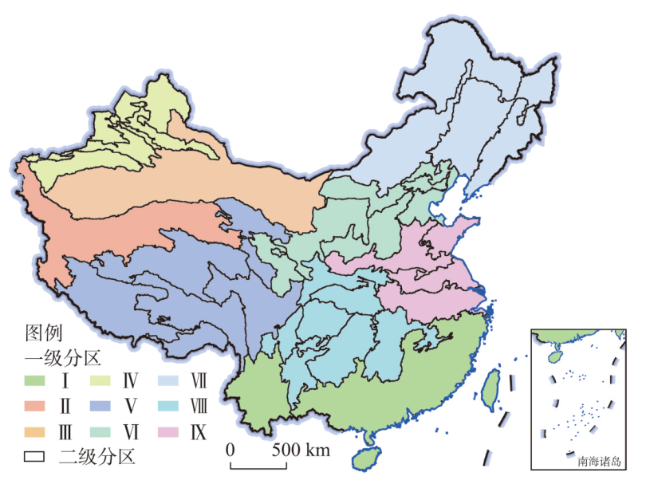
表3 植被物候特征显著一级分区的二级区划指标筛选结果与分区数量Tab. 3 Screening results of the second-level regionalization indicator for the first-level regions with significant phenological characteristics and the number of their second-level regions |
| 一级分区编码 | 二级区划指标筛选结果 | 二级分区数量 |
|---|---|---|
| Ⅳ | OM、LOS | 5 |
| Ⅴ | OM、LOS | 6 |
| Ⅵ | OM、LOS | 5 |
| Ⅶ | SOS、EOS | 4 |
| Ⅷ | OM、LOS | 7 |
| Ⅸ | EOS | 4 |
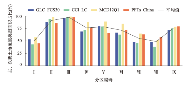
表4 遥感物候模式一级分区主要土地覆被统计结果Tab. 4 Primary land cover types and their proportions of area for different land cover products in the first-level regions of the remotely-sensed phenology pattern regionalization |
| 分区 | GLC_FCS30 | CCI_LC | MCD12Q1 | PFTs_China | ||||
|---|---|---|---|---|---|---|---|---|
| 名称 | 占比(%) | 名称 | 占比(%) | 名称 | 占比(%) | 名称 | 占比(%) | |
| Ⅰ | 常绿阔叶林 | 33.91 | 常绿阔叶林 | 22.44 | 稀树草原 | 28.82 | 常绿针叶林 | 22.86 |
| Ⅱ | 裸地/稀疏植被 | 48.86 | 裸地/稀疏植被 | 48.67 | 裸地/稀疏植被 | 88.82 | 裸地/稀疏植被 | 53.86 |
| Ⅲ | 裸地/稀疏植被 | 93.54 | 裸地/稀疏植被 | 89.83 | 裸地/稀疏植被 | 94.83 | 裸地/稀疏植被 | 93.38 |
| Ⅳ | 裸地/稀疏植被 | 45.50 | 裸地/稀疏植被 | 44.43 | 草地 | 55.09 | 裸地/稀疏植被 | 39.09 |
| Ⅴ | 草地 | 65.13 | 草地 | 70.54 | 草地 | 74.04 | C3高寒草地 | 50.78 |
| Ⅵ | 草地 | 39.94 | 草地 | 44.33 | 草地 | 63.21 | C3草地 | 40.03 |
| Ⅶ | 旱地 | 24.05 | 旱地 | 24.43 | 草地 | 37.99 | C3草地 | 33.20 |
| Ⅷ | 旱地 | 23.96 | 旱地 | 21.39 | 有林草地 | 31.79 | 耕地 | 39.00 |
| Ⅸ | 旱地 | 39.92 | 水浇地 | 41.30 | 耕地 | 71.30 | 耕地 | 69.50 |
表5 遥感物候模式一级分区次要土地覆被统计结果Tab. 5 Secondary land cover types and their proportions of area for different land cover products in the first-level regions of the remotely-sensed phenology pattern regionalization |
| 分区 | GLC_FCS30 | CCI_LC | MCD12Q1 | PFTs_China | ||||
|---|---|---|---|---|---|---|---|---|
| 名称 | 占比(%) | 名称 | 占比(%) | 名称 | 占比(%) | 名称 | 占比(%) | |
| Ⅰ | 常绿针叶林 | 19.21 | 常绿针叶林 | 20.48 | 有林草地 | 28.21 | 耕地 | 22.30 |
| Ⅱ | 草地 | 38.77 | 草地 | 45.07 | 草地 | 8.79 | C3高寒草地 | 31.78 |
| Ⅲ | 草地 | 2.81 | 草地 | 7.81 | 草地 | 3.91 | C3草地 | 4.03 |
| Ⅳ | 草地 | 23.31 | 草地 | 27.49 | 裸地/稀疏植被 | 33.23 | C3草地 | 37.36 |
| Ⅴ | 裸地/稀疏植被 | 14.35 | 常绿针叶林 | 8.45 | 裸地/稀疏植被 | 14.74 | 裸地/稀疏植被 | 15.49 |
| Ⅵ | 旱地 | 26.80 | 旱地 | 18.36 | 耕地 | 21.24 | 耕地 | 31.87 |
| Ⅶ | 落叶阔叶林 | 24.00 | 草地 | 21.16 | 耕地 | 26.60 | 耕地 | 29.64 |
| Ⅷ | 常绿阔叶林 | 23.61 | 常绿阔叶林 | 16.84 | 稀树草原 | 20.09 | C3草地 | 18.80 |
| Ⅸ | 水浇地 | 31.53 | 旱地 | 33.80 | 不透水面 | 7.10 | 不透水面 | 9.64 |
| [1] |
|
| [2] |
|
| [3] |
[张兵, 杨晓梅, 高连如, 等. 遥感大数据智能解译的地理学认知模型与方法. 测绘学报, 2022, 51(7): 1398-1415.]
|
| [4] |
[杨晓梅, 王志华, 刘岳明, 等. 遥感智能信息处理的发展及技术前景. 同济大学学报(自然科学版), 2023, 51(7): 1025-1032.]
|
| [5] |
|
| [6] |
[王志华, 杨晓梅, 周成虎. 面向遥感大数据的地学知识图谱构想. 地球信息科学学报, 2021, 23(1): 16-28.]
|
| [7] |
[王志华, 杨晓梅, 刘岳明, 等. 面向对象影像分析的地理学原理及分析框架启示. 遥感学报, 2023, 28(6): 1412-1424.]
|
| [8] |
[王志华, 杨晓梅, 张俊瑶, 等. 面向复杂自然场景的遥感地学分区智能解译框架及初探. 地球信息科学学报, 1-26. http://kns.cnki.net/kcms/detail/11.5809.P.20240226.0933.006.html.]
|
| [9] |
[傅伯杰, 陈利顶, 刘国华. 中国生态区划的目的、任务及特点. 生态学报, 1999, 19(5): 591-595.]
|
| [10] |
[郑度, 欧阳, 周成虎. 对自然地理区划方法的认识与思考. 地理学报, 2008, 63(6): 563-573.]
|
| [11] |
|
| [12] |
|
| [13] |
[郝莹莹, 罗小波, 仲波, 等. 基于植被分区的中国植被类型分类方法. 遥感技术与应用, 2017, 32(2): 315-323.]
|
| [14] |
|
| [15] |
|
| [16] |
|
| [17] |
|
| [18] |
|
| [19] |
|
| [20] |
|
| [21] |
[王连喜, 陈怀亮, 李琪, 等. 植物物候与气候研究进展. 生态学报, 2010, 30(2): 447-454.]
|
| [22] |
|
| [23] |
|
| [24] |
|
| [25] |
[王敏钰, 罗毅, 张正阳, 等. 植被物候参数遥感提取与验证方法研究进展. 遥感学报, 2022, 26(3): 431-455.]
|
| [26] |
|
| [27] |
|
| [28] |
|
| [29] |
|
| [30] |
|
| [31] |
|
| [32] |
|
| [33] |
|
| [34] |
|
| [35] |
[周成虎, 程维明, 钱金凯, 等. 中国陆地1∶100万数字地貌分类体系研究. 地球信息科学学报, 2009, 11(6): 707-724.]
|
| [36] |
[程维明, 周成虎, 李炳元, 等. 中国地貌区划理论与分区体系研究. 地理学报, 2019, 74(5): 839-856.]
|
| [37] |
[杨勤业, 郑度, 吴绍洪. 中国的生态地域系统研究. 自然科学进展, 2002, 12(3): 287-291.]
|
| [38] |
[吴绍洪, 杨勤业, 郑度. 生态地理区域系统的比较研究. 地理学报, 2003, 58(5): 686-694.]
|
| [39] |
|
| [40] |
Copernicus Climate Change Service,
|
| [41] |
|
| [42] |
|
| [43] |
|
| [44] |
|
| [45] |
|
| [46] |
|
| [47] |
|
| [48] |
|
| [49] |
|
| [50] |
|
| [51] |
|
| [52] |
[崔林丽, 史军, 杜华强. 植被物候的遥感提取及其影响因素研究进展. 地球科学进展, 2021, 36(1): 9-16.]
|
| [53] |
|
| [54] |
|
| [55] |
|
| [56] |
|
| [57] |
|
| [58] |
|
| [59] |
|
| [60] |
|
| [61] |
[金佳鑫, 季盈盈, 郭丰生, 等. 基于遥感数据的多年平均物候不确定性研究. 遥感学报, 2022, 26(9): 1814-1823.]
|
| [62] |
|
| [63] |
|
| [64] |
|
| [65] |
|
| [66] |
|
| [67] |
|
| [68] |
|
| [69] |
|
| [70] |
[靖娟利, 王永锋. 1998—2012年中国西南岩溶区植被覆盖时空变化分析. 水土保持研究, 2014, 21(4): 163-167.]
|
| [71] |
[靖娟利, 王永锋. 西南岩溶区NDVI时空变化及其与气候因子的关系. 水土保持研究, 2016, 23(5): 169-174.]
|
| [72] |
|
| [73] |
|
| [74] |
|
| [75] |
|
| [76] |
|
| [77] |
|
| [78] |
|
| [79] |
|
| [80] |
|
| [81] |
|
/
| 〈 |
|
〉 |