
Development of an eco-hydrological model for flood and drought risk assessment under a changing environment in the middle reaches of the Yellow River
Received date: 2023-02-10
Revised date: 2023-04-06
Online published: 2023-08-01
Supported by
National Natural Science Foundation of China(U2243226)
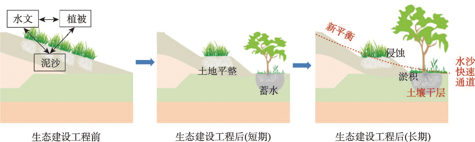
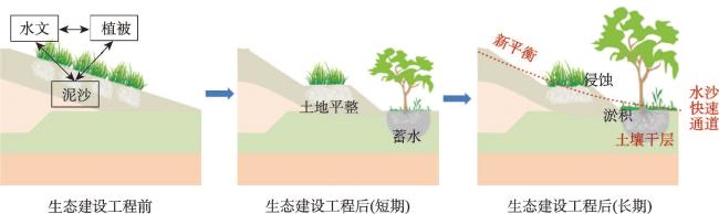
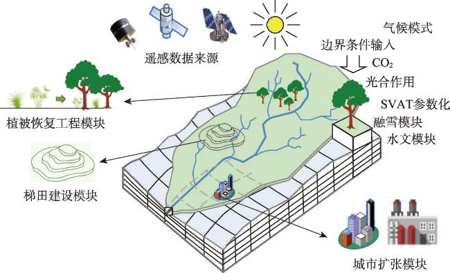
The middle reaches of Yellow River basin, with a fragile ecological environment, are vulnerable to serious flood and drought disasters. In recent years, the controls on soil and water loss in the middle reaches of the Yellow River have been steadily improving under the influence of human activities such as large-scale terrace construction and vegetation restoration projects. These soil and water conservation measures play an important role in flood control, drought relief and disaster reduction. However, at the same time, vegetation construction in the middle reaches of the Yellow River has led to the intensification of dry soil layers, a decrease in runoff and sediment yields, and an increased hydrological drought risk. Urban expansion has also led to drastic change in this disaster-prone environment, including an increased rainstorm and flood peaks in urbanized areas, and increased flood and drought risks. In the middle reaches of the Yellow River basin, the hydrology, sediment and vegetation evolution is highly inter-connected and co-developed. With disturbance from human activities, a new hydrology-sediment-vegetation balance will form. At present, however, the co-evolution processes and mechanisms of the hydrology-sediment-vegetation balance in the basin under a changing environment is not clearly understood. The impact of large-scale distributed human activities such as terrace construction, vegetation restoration projects and urban expansion, on flood and drought disaster risks needs to be scientifically assessed. An intelligent eco-hydrological model of the Yellow River middle reaches under a changing environment should be developed to predict the long-term subsequent impact of large-scale human activities on flood and drought disaster risks. These improvements can provide scientific and technological support for the coordinated development of ecological construction and water conservancy projects in the middle reaches of the Yellow River, serving the effective prevention and mitigation of flood and drought disaster risks.
TANG Qiuhong , XU Ximeng , HE Li , PENG Shouzhang , HU Yawei , JIN Xiaohui , FAN Yumiao , GAFFNEY Paul Patrick Joseph , ZHU Xinrong , DENG Haoxin , YANG Lin , WANG Zhihui . Development of an eco-hydrological model for flood and drought risk assessment under a changing environment in the middle reaches of the Yellow River[J]. Acta Geographica Sinica, 2023 , 78(7) : 1666 -1676 . DOI: 10.11821/dlxb202307008
| [1] |
[ 杨大文, 杨雨亭, 高光耀, 等. 黄河流域水循环规律与水土过程耦合效应. 中国科学基金, 2021, 35(4): 544-551.]
|
| [2] |
[ 刘昌明, 田巍, 刘小莽, 等. 黄河近百年径流量变化分析与认识. 人民黄河, 2019, 41(10): 11-15.]
|
| [3] |
[ 马柱国, 符淙斌, 周天军, 等. 黄河流域气候与水文变化的现状及思考. 中国科学院院刊, 2020, 35(1): 52-60.]
|
| [4] |
|
| [5] |
[ 杨胜天, 周旭, 刘晓燕, 等. 黄河中游多沙粗沙区(渭河段)土地利用对植被盖度的影响. 地理学报, 2014, 69(1): 31-41.]
|
| [6] |
[ 罗娅, 杨胜天, 刘晓燕, 等. 黄河河口镇—潼关区间1998—2010年土地利用变化特征. 地理学报, 2014, 69(1): 42-53.]
|
| [7] |
[ 张志强, 王盛萍, 孙阁, 等. 流域径流泥沙对多尺度植被变化响应研究进展. 生态学报, 2006, 26(7): 2356-2364.]
|
| [8] |
[ 王根绪, 刘桂民, 常娟. 流域尺度生态水文研究评述. 生态学报, 2005, 25(4), 892-903.]
|
| [9] |
|
| [10] |
[ 丁永建, 周成虎, 邵明安, 等. 地表过程研究进展与趋势. 地球科学进展, 2013, 28(4): 407-419.]
|
| [11] |
[ 张亦弛, 刘昌明, 杨胜天, 等. 黄土高原典型流域LCM模型集总、半分布和分布式构建对比分析. 地理学报, 2014, 69(1): 90-99.]
|
| [12] |
[ 王浩, 胡鹏. 水循环视角下的黄河流域生态保护关键问题. 水利学报, 2020, 51(9): 1009-1014.]
|
| [13] |
[ 刘国彬, 上官周平, 姚文艺, 等. 黄土高原生态工程的生态成效. 中国科学院院刊, 2017, 32(1): 11-19.]
|
| [14] |
[ 胡春宏, 张晓明. 黄土高原水土流失治理与黄河水沙变化. 水利水电技术, 2020, 51(1): 1-11.]
|
| [15] |
|
| [16] |
|
| [17] |
|
| [18] |
[ 穆兴民, 顾朝军, 孙文义, 等. 植被恢复改变黄土高原产流模式问题初探. 人民黄河, 2019, 41(10): 31-39.]
|
| [19] |
[ 邵明安, 贾小旭, 王云强, 等. 黄土高原土壤干层研究进展与展望. 地球科学进展, 2016, 31(1): 14-22.]
|
| [20] |
|
| [21] |
[ 高红凯, 刘俊国, 高光耀, 等. 水源涵养功能概念的生态和水文视角辨析. 地理学报, 2023, 78(1): 139-148.]
|
| [22] |
|
| [23] |
|
| [24] |
Yellow River Conservancy Commission of MWR. Soil and Water Conservation Bulletin in Yellow River Basin (2021). 2022-12-01. http://www.yrcc.gov.cn/sylm/2022stbcgb/2022stbcgbgb/202212/P020221201610028983969.pdf.
[ 水利部黄河水利委员会. 黄河流域水土保持公报(2021年). 2022-12-01. http://www.yrcc.gov.cn/sylm/2022stbcgb/2022stbcgbgb/202212/P020221201610028983969.pdf.]
|
| [25] |
|
| [26] |
[ 任保平, 杜翔宇. 黄河中游地区生态保护和高质量发展战略研究. 人民黄河, 2021, 43(2): 1-5.]
|
| [27] |
[ 姚文艺, 侯素珍, 郭彦, 等. 陕北绥德县、子洲县城区2017年“7·26”暴雨致灾成因分析. 中国防汛抗旱, 2018, 28(9): 27-32, 49.]
|
| [28] |
|
| [29] |
|
| [30] |
|
| [31] |
[ 刘丙霞, 任健, 邵明安, 等. 黄土高原北部人工灌草植被土壤干燥化过程研究. 生态学报, 2020, 40(11): 3795-3803.]
|
| [32] |
[ 白晓, 贾小旭, 邵明安, 等. 黄土高原北部土地利用变化对长期土壤水分平衡影响模拟. 水科学进展, 2021, 32(1):109-119.]
|
| [33] |
|
| [34] |
[ 佘冬立, 邵明安, 俞双恩. 黄土高原典型植被覆盖下SPAC系统水量平衡模拟. 农业机械学报, 2011, 42(5): 73-78.]
|
| [35] |
|
| [36] |
[ 邸苏闯, 游松财, 刘喆惠. 基于GIS的水量平衡模型在黄土高原地区土壤水分模拟中的应用. 中国农村水利水电, 2012(5): 11-14, 17.]
|
| [37] |
[ 莫兴国, 刘苏峡, 林忠辉, 等. 无定河流域水量平衡变化的模拟. 地理学报, 2004, 59(3): 341-348.]
|
| [38] |
|
| [39] |
[ 薛帆, 张晓萍, 张橹, 等. 基于Budyko假设和分形理论的水沙变化归因识别: 以北洛河流域为例. 地理学报, 2022, 77(1): 79-92.]
|
| [40] |
[ 汤秋鸿, 刘星才, 李哲, 等. 陆地水循环过程的综合集成与模拟. 地球科学进展, 2019, 34(2): 115-123.]
|
| [41] |
|
| [42] |
|
| [43] |
|
| [44] |
|
| [45] |
[ 汤秋鸿, 黄忠伟, 刘星才, 等. 人类用水活动对大尺度陆地水循环的影响. 地球科学进展, 2015, 30(10): 1091-1099.]
|
| [46] |
|
| [47] |
|
| [48] |
|
| [49] |
|
| [50] |
|
| [51] |
|
| [52] |
[ 张博美, 高红凯, 佘敦先, 等. 以地形为基础的HSC产流模型在辽西半干旱丘陵流域的适用性. 南水北调与水利科技(中英文), 2021, 19(6): 1072-1082.]
|
| [53] |
|
| [54] |
|
| [55] |
|
| [56] |
[ 祁添垚, 张强, 孙鹏, 等. 气候变暖对中国洪旱极端事件演变趋势影响研究. 自然灾害学报, 2015, 24(3): 143-152.]
|
| [57] |
|
| [58] |
|
| [59] |
|
| [60] |
|
| [61] |
|
| [62] |
|
| [63] |
|
/
| 〈 |
|
〉 |