
Mapping spatio-temporal variation of river width from satellite remote sensing data and hydrometeorological response in the Yarlung Zangbo River
Received date: 2022-02-18
Revised date: 2022-09-28
Online published: 2022-12-27
Supported by
Strategic Priority Research Program of the Chinese Academy of Sciences(XDA23100102)
Second Tibetan Plateau Scientific Expedition and Research(2019QZKK0202)
National Natural Science Foundation of China(41971403)
Lake-Watershed Science Data Center, National Earth System Science Data Center and the 14th Five-year Network Security and Informatization Plan of Chinese Academy of Sciences(WX145XQ06-04/CAS-WX2021SF-0306)
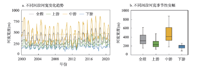
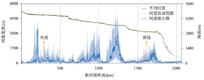
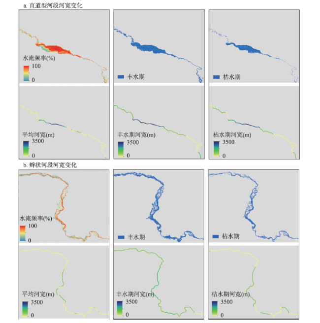
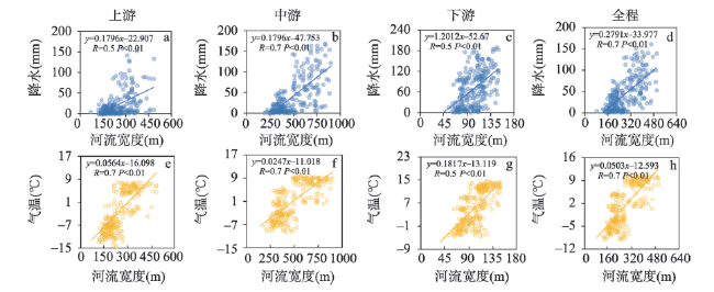
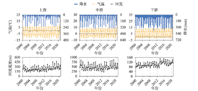
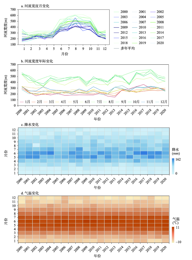
River width, as one of the basic parameters of river morphology, is very important to understand the hydrological process and ecosystem function on Earth. The Yarlung Zangbo River is not only a global plateau river with typical regional characteristics, but also an important international river. However, due to its remote location, mountainous terrains, and harsh environmental conditions, the gauge stations are sparsely distributed in the Yarlung Zangbo River, which greatly impedes a better understanding of its hydrological dynamic characteristics. Satellite remote sensing makes it possible to monitor and analyze the wide and long-term dynamic changes and to examine the hydrological characteristics of the Yarlung Zangbo River by providing multi-temporal image data. Based on the Global Land Analysis and Discovery (GLAD) dataset and the threshold segmentation method of water boundary inundation frequency, this study reconstructed the complete monthly water area of the study area, and then estimated the spatial and temporal distribution of the river width from 2000 to 2020. The results indicate that due to the seasonal differences in temperature and precipitation, the width of the river showed a significant seasonal variation from 2000 to 2020. The seasonal variation in the middle reaches was the largest (453.6 m), while that of the downstream was the smallest (90.3 m). Influenced by climate and topography, the spatial distribution of river width in the whole course of the Yarlung Zangbo River varies greatly. The narrowest part of the observed river channel is about 30 m, i.e., a spatial resolution of Landsat images. The maximum river width in the middle and lower reaches of braided rivers can reach 5935.7 m. About 50% of the river segments of the Yarlung Zangbo River are narrower than 150 m, and only 2.0% of the river segments are wider than 2000 m. From 2000 to 2020, the average river width of the main stream first decreased, then increased and finally decreased. There was a very significant positive correlation between the mean river width of the mainstream and precipitation and air temperature, and the correlation coefficient R was 0.7, which passed the confidence test of 0.01. In addition, the monthly river width based on GLAD was also evaluated by the river width results derived from 10 m resolution Sentinel-2 data. The results showed that both of the relative deviations were less than 2%, indicating that the estimation results were relatively reliable in general.
XU Jiahui , WANG Shidong , SONG Lijuan , ZHANG Dapeng , SONG Chunqiao . Mapping spatio-temporal variation of river width from satellite remote sensing data and hydrometeorological response in the Yarlung Zangbo River[J]. Acta Geographica Sinica, 2022 , 77(11) : 2862 -2877 . DOI: 10.11821/dlxb202211011
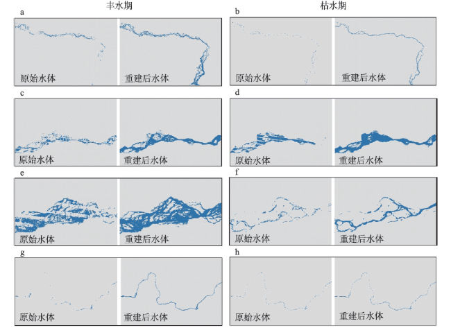
表1 重建水体混淆矩阵精度评价Tab. 1 Accuracy evaluation of the confusion matrix applied to the reconstructed water body |
| 日期 | PA(%) | OA(%) | UA(%) | Kappa系数 |
|---|---|---|---|---|
| 2019年3月 | 86.9 | 82.2 | 82.5 | 0.9 |
| 2019年7月 | 82.6 | 85.0 | 84.2 | 0.8 |
| 2019年10月 | 89.0 | 88.4 | 88.2 | 0.9 |
图8 雅鲁藏布江不同区域河宽变化Fig. 8 Variation of river width in different parts of Yarlung Zangbo River |
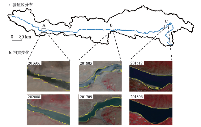
表2 河宽变化结果精度评价表Tab. 2 Reconstruction results of incomplete water body of the Yarlung Zangbo River |
| 位置 | 时间 | 基于GLAD估算(m) | 基于Sentinel-2估算河宽(m) | 相对偏差(%) |
|---|---|---|---|---|
| A | 2016年6月 | 119.6 | 121.4 | 1.5 |
| 2020年8月 | 137.9 | 139.3 | 1.0 | |
| B | 2017年9月 | 144.4 | 147.0 | 1.8 |
| 2018年5月 | 131.5 | 131.8 | 0.2 | |
| C | 2015年12月 | 452.0 | 453.2 | 0.3 |
| 2018年6月 | 391.1 | 393.5 | 0.6 |
| [1] |
|
| [2] |
|
| [3] |
|
| [4] |
[史卓琳, 黄昌. 河流水情要素遥感研究进展. 地理科学进展, 2020, 39(4): 670-684.]
|
| [5] |
[章斯腾, 陆欣, 陆瑶, 等. 青藏高原河流网络高分CubeSat遥感监测. 遥感学报, 2021, 25(10): 2142-2152.]
|
| [6] |
|
| [7] |
|
| [8] |
|
| [9] |
|
| [10] |
|
| [11] |
|
| [12] |
|
| [13] |
[江科. 雅鲁藏布江流域径流组成及其对气候变化的响应[D]. 哈尔滨: 哈尔滨工业大学, 2020.]
|
| [14] |
|
| [15] |
[刘纪远, 匡文慧, 张增祥, 等. 20世纪80年代末以来中国土地利用变化的基本特征与空间格局. 地理学报, 2014, 69(1): 3-14.]
|
| [16] |
[何大明, 刘昌明, 冯彦, 等. 中国国际河流研究进展及展望. 地理学报, 2014, 69(9): 1284-1294.]
|
| [17] |
|
| [18] |
|
| [19] |
[薛鹏飞, 余钟波, 谷黄河. 雅鲁藏布江流域GPM和TRMM遥感降水产品精度评估. 水电能源科学, 2020, 38(11): 13-16.]
|
| [20] |
[张茹, 雍斌, 曾岁康. GPM卫星降水产品在中国大陆的精度评估. 人民长江, 2021, 52(5): 50-59.]
|
| [21] |
[吕洋, 杨胜天, 蔡明勇, 等. TRMM卫星降水数据在雅鲁藏布江流域的适用性分析. 自然资源学报, 2013, 28(8): 1414-1425.]
|
| [22] |
|
| [23] |
|
| [24] |
|
| [25] |
[刘志红,
|
| [26] |
|
| [27] |
|
| [28] |
|
| [29] |
|
| [30] |
|
| [31] |
|
| [32] |
|
| [33] |
|
| [34] |
|
| [35] |
|
| [36] |
|
| [37] |
|
| [38] |
[李治. 雅鲁藏布江宽谷河段辫状河流地貌特征与演变规律研究[D]. 北京: 清华大学, 2019.]
|
| [39] |
|
| [40] |
|
| [41] |
|
| [42] |
|
| [43] |
|
| [44] |
|
| [45] |
|
| [46] |
|
| [47] |
|
| [48] |
|
| [49] |
[侯极, 周勤, 张春泽, 等. 雅鲁藏布江中游游荡型河道演变规律及趋势预测. 科学技术与工程, 2018, 18(28): 143-150.]
|
| [50] |
|
/
| 〈 |
|
〉 |