
The coupling characteristics of the shipping network and trade between China and the countries along the 21st Century Maritime Silk Road
Received date: 2021-03-24
Revised date: 2022-02-14
Online published: 2022-08-19
Supported by
National Natural Science Foundation of China(41871112)
LiaoNing Revitalization Talents Program(XLYC2007174)
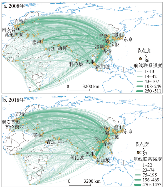
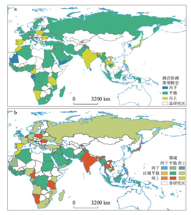
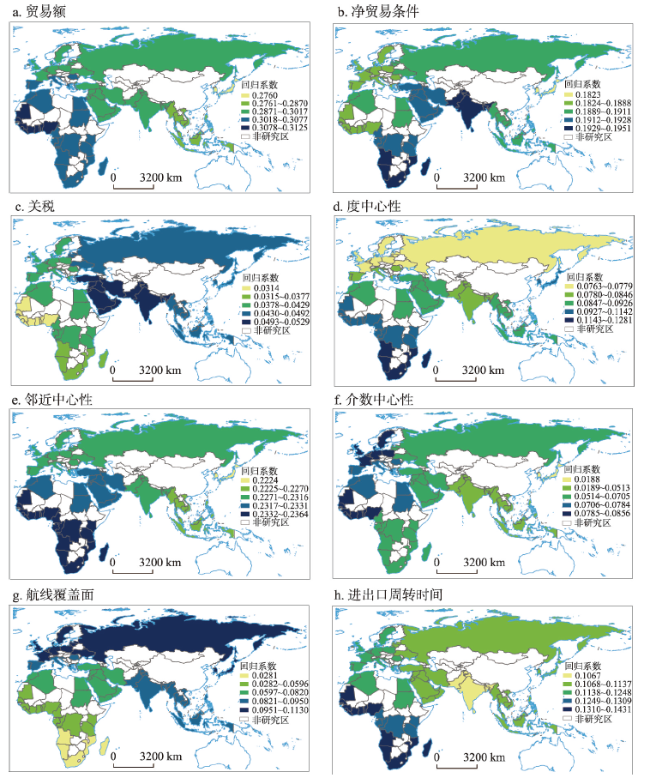
As the material carrier of international trade, the shipping network that has been formed between China and the countries along the Belt and Road is an important support for the prosperity and development of the Maritime Silk Road. In this paper, a complex network model was used to characterize the port shipping network between China and the countries along the Maritime Silk Road in 2008 and 2018. Then, the coupling characteristics of the network and trade of various countries were analyzed by constructing an index system to reveal the shipping network's ability to support trade. Finally, spatial heterogeneity of influencing factors was analyzed by using geographically and temporally weighted regression model. The results show that: (1) on the whole, the port shipping network in 2008 and 2018 had obvious complex network characteristics. Network density increased by 111%, while its overall operating efficiency decreased by 8.73%. (2) The coordination degree between the shipping network and trade increased by 5%. It is also noted that most well-performed countries were distributed in East Asia and Southeast Asia. By 2018, about 36% of the shipping network of countries along the Maritime Silk Road lagged behind the level of trade, resulting in a significant shortage of shipping support. About 28% of the shipping elements of countries along the route were oversupplied. Most of the remaining countries evolved from low-level coordination to intermediate coordination. From a regional perspective, the coordination of these countries had obvious space club convergence. (3) There were obvious regional differences in the factors influencing the coupling relationship. In general, the scale of trade, the efficiency of port shipping and the economic benefit of foreign trade are the most important factors that promote the synergy effect of the shipping networks and trade, while the coverage of liner routes, port transit capacity and trade barriers are not so influential.
GUO Jianke , LIANG Muxin . The coupling characteristics of the shipping network and trade between China and the countries along the 21st Century Maritime Silk Road[J]. Acta Geographica Sinica, 2022 , 77(6) : 1531 -1545 . DOI: 10.11821/dlxb202206016
表1 国际航运网络及经贸联系评价指标体系Tab. 1 Evaluation index system of international shipping network and trade |
| 一级指标 | 二级指标(功效) | 表达含义 | 来源 |
|---|---|---|---|
| 航运 (μ1) | 邻近中心性(+) | 反映节点在网络中的相对可达性,体现节点的航运效率 | 利用《中国航务周刊》《中国港口年鉴》统计、运用复杂网络模型计算得到 |
| 介数中心性(+) | 反映节点在网络中的中转和衔接功能,体现节点的调节能力 | ||
| 度中心性(+) | 反映节点与其他节点发生直接联系的可能性,体现节点的对外交流能力 | ||
| 航线覆盖面/条(+) | 反映航线覆盖范围及通达能力 | ||
| 进出口周转时间(-) | 指从发货点到装货港再到收货人的中值时间,反映周转效率 | 世界银行 | |
| 经贸 (μ2) | 外贸额/亿美元(+) | 反映一个国家在对外贸易方面的总规模的重要指标 | UN Comtrade |
| 净贸易条件指数(+) | 衡量在一定时期内一国出口相对于进口的盈利能力和贸易利益的指标,反映一国宏观上对外贸易的经济效益,在双边贸易中尤为重要 | 世界银行 | |
| 关税(-) | 关税越高,对国家间贸易的阻碍越大 | 《全球竞争力报告》 |
表2 航运网络及经贸联系耦合协调类别划分标准Tab. 2 Classification criteria of shipping network and trade |
| 耦合协调度 | 相对发展度 | 类型 | 耦合协调类型特征 | 发展阶段 |
|---|---|---|---|---|
| 0 ≤ D ≤ 0.45 | 0 < E ≤ 0.8 | Ⅰ | 航运网络滞后于经贸发展,制约经贸发展,航运网络要素的支撑能力不足,系统退化。 | 失调衰退 |
| 0.8 < E < 1.2 | Ⅱ | 航运网络同步于经贸发展,推动经贸发展,航运网络要素的支撑能力发挥较好,系统优化。 | ||
| 1.2 ≤ E | Ⅲ | 航运网络超前于经贸发展,影响经贸发展,航运网络要素的支撑作用尚未充分发挥,系统退化。 | ||
| 0.45 < D < 0.65 | 0 < E ≤ 0.8 | Ⅳ | 航运网络滞后于经贸发展,制约经贸发展,航运网络要素的支撑能力不足,系统退化。 | 转型升级 |
| 0.8 < E < 1.2 | Ⅴ | 航运网络同步于经贸发展,推动经贸发展,航运网络要素的支撑能力发挥较好,系统优化。 | ||
| 1.2 ≤ E | Ⅵ | 航运网络超前于经贸发展,影响经贸发展,航运网络要素的支撑作用尚未充分发挥,系统退化。 | ||
| 0.65 ≤ D ≤ 1 | 0 < E ≤ 0.8 | Ⅶ | 航运网络滞后于经贸发展,制约经贸发展,航运网络要素的支撑能力不足,系统退化。 | 协调发展 |
| 0.8 < E < 1.2 | Ⅷ | 航运网络同步于经贸发展,推动经贸发展,航运网络要素的支撑能力发挥较好,系统优化。 | ||
| 1.2 ≤ E | Ⅸ | 航运网络超前于经贸发展,影响经贸发展,航运网络要素的支撑作用尚未充分发挥,系统退化。 |
表3 中国与“海上丝路”沿线国家航运网络及经贸联系耦合协调度发展评价Tab. 3 Evaluation of the coupling coordination of the shipping network and trade between China and the countries along the Maritime Silk Road |
| 年份 | 航运滞后型 | 相对同步型 | 航运超前型 |
|---|---|---|---|
| 2008 | 阿尔及利亚Ⅰ、喀麦隆Ⅰ、波兰Ⅰ、柬埔寨Ⅰ、越南Ⅰ、阿联酋Ⅳ、阿曼Ⅳ、安哥拉Ⅳ、俄罗斯Ⅳ、日本Ⅳ、韩国Ⅳ、加蓬Ⅳ、文莱Ⅳ、也门Ⅳ、伊朗Ⅳ等35国 | 贝宁Ⅱ、克罗地亚Ⅱ、葡萄牙Ⅱ、乌克兰Ⅱ、以色列Ⅱ、印度Ⅱ、泰国Ⅱ、德国Ⅴ、意大利Ⅴ、英国Ⅴ、法国Ⅴ、科特迪瓦Ⅴ、南非Ⅴ、沙特Ⅴ、马来西亚Ⅴ等25国 | 巴基斯坦Ⅲ、多哥Ⅲ、菲律宾Ⅲ、吉布提Ⅲ、肯尼亚Ⅲ、罗马尼亚Ⅲ、毛里求斯Ⅲ、土耳其Ⅲ、西班牙Ⅲ、希腊Ⅲ、埃及Ⅵ、斯里兰卡Ⅵ、新加坡Ⅸ等18国 |
| 2018 | 阿尔及利亚Ⅰ、叙利亚Ⅰ、加蓬Ⅰ、也门Ⅰ、喀麦隆Ⅳ、安哥拉Ⅳ、俄罗斯Ⅳ、韩国Ⅳ、文莱Ⅳ、伊拉克Ⅳ、德国Ⅳ、加纳Ⅳ、日本Ⅶ等28国 | 贝宁Ⅱ、克罗地亚Ⅱ、乌克兰Ⅱ、越南Ⅴ、以色列Ⅴ、印度Ⅴ、毛里求斯Ⅴ、阿联酋Ⅴ、伊朗Ⅴ、印尼Ⅴ、法国Ⅴ、科特迪瓦Ⅴ、南非Ⅴ、沙特Ⅴ、意大利Ⅴ、英国Ⅴ、埃及Ⅴ等28国 | 柬埔寨Ⅲ、巴基斯坦Ⅲ、吉布提Ⅲ、肯尼亚Ⅲ、土耳其Ⅲ、泰国Ⅵ、多哥Ⅵ、菲律宾Ⅵ、西班牙Ⅵ、希腊Ⅵ、马来西亚Ⅵ、斯里兰卡Ⅵ、新加坡Ⅸ等22国 |
表4 中国与“海上丝路”沿线各区域的航运网络及经贸联系耦合协调度的分类Tab. 4 Classification of coupling coordination degree of the shipping network and trade in the regions along the Maritime Silk Road |
| 年份 | 失调衰退 | 转型升级 | 协调发展 |
|---|---|---|---|
| 2008 | 地中海欧洲,西北欧,东欧*,中—东非*、 西非、南部非洲*,西亚*,南亚** | 北非*,东南亚,东亚* | - |
| 2018 | 北非*,西非*,中—东非*,东欧* | 地中海欧洲**,东南亚**,东亚*,南部非洲, 南亚**,西北欧,西亚* | - |
注:*、**分别表示航运要素相对滞后型和航运要素相对过剩,其余为航贸要素相对同步。 |
表5 2008—2018年中国与“海上丝路”沿线国家航运网络及经贸联系耦合特征的空间马尔可夫转移矩阵Tab. 5 Spatial Markov transfer matrix of the coupling characteristics of the shipping network and trade between China and the countries along the Maritime Silk Road from 2008 to 2018 |
| 空间滞后 | 耦合类型 | 失调衰退 | 转型升级 | 协调发展 |
|---|---|---|---|---|
| 失调衰退 | 失调衰退 | 0.63 | 0.37 | 0.00 |
| 转型升级 | 0.08 | 0.92 | 0.00 | |
| 协调发展 | 0.00 | 0.00 | 0.00 | |
| 转型升级 | 失调衰退 | 0.52 | 0.48 | 0.00 |
| 转型升级 | 0.17 | 0.75 | 0.08 | |
| 协调发展 | 0.00 | 0.00 | 1.00 | |
| 协调发展 | 失调衰退 | 0.00 | 0.00 | 0.00 |
| 转型升级 | 0.00 | 1.00 | 0.00 | |
| 协调发展 | 0.00 | 0.00 | 0.00 |
| [1] |
[肖作鹏. 从城市物流规划到城市供应链规划. 城市交通, 2021, 19(2): 37-45, 54.]
|
| [2] |
|
| [3] |
|
| [4] |
[章秀琴, 余长婧. “一带一路”基础设施建设的贸易效应研究. 国际商务, 2019(1): 72-83.]
|
| [5] |
[吕越, 陆毅, 吴嵩博, 等. “一带一路”倡议的对外投资促进效应: 基于2005—2016年中国企业绿地投资的双重差分检验. 经济研究, 2019, 54(9): 187-202.]
|
| [6] |
[梁双陆, 张梅. 基础设施互联互通对我国与周边国家贸易边界效应的影响. 亚太经济, 2016(1): 101-106.]
|
| [7] |
[王全良. 基于动态空间模型的中国临空经济区与腹地区域经济关系研究. 地理研究, 2017, 36(11): 2141-2155.]
|
| [8] |
[王成金, 于良. 世界集装箱港的形成演化及与国际贸易的耦合机制. 地理研究, 2007, 26(3): 557-568.]
|
| [9] |
[王列辉, 林羽珊,
|
| [10] |
[姜宝, 李剑, 宫春霞. “海上丝绸之路”上的航运与贸易关联度研究. 世界经济研究, 2015(7): 81-88, 129.]
|
| [11] |
[郭建科, 韩增林. 中国海港城市“港—城空间系统”演化理论与实证. 地理科学, 2013, 33(11): 1285-1292.]
|
| [12] |
[陈航. 论海港地域组合的形成机制与发展过程. 地理学报, 1996, 51(6): 501-507.]
|
| [13] |
|
| [14] |
[王列辉, 朱艳. 基于“21世纪海上丝绸之路”的中国国际航运网络演化. 地理学报, 2017, 72(12): 2265-2280.]
|
| [15] |
[郭建科, 侯雅洁, 何瑶. “一带一路”背景下中欧港口航运网络的演化特征. 地理科学进展, 2020, 39(5): 716-726.]
|
| [16] |
[王成, 王茂军, 王艺. 中国嵌入“21世纪海上丝绸之路”航运网络的关键节点识别. 地理科学进展, 2018, 37(11): 1485-1498.]
|
| [17] |
|
| [18] |
|
| [19] |
[袁莉琳, 季鹏. “21世纪海上丝绸之路”沿线区域枢纽港优化选择. 经济地理, 2017, 37(11): 1-9.]
|
| [20] |
|
| [21] |
[曹有挥, 梁双波, 吴威, 等. 枢纽港口城市港航服务业空间组织机理: 以上海市为例. 地理学报, 2017, 72(12): 2226-2240.]
|
| [22] |
|
| [23] |
[宋周莺, 车姝韵, 杨宇. “一带一路”贸易网络与全球贸易网络的拓扑关系. 地理科学进展, 2017, 36(11): 1340-1348.]
|
| [24] |
|
| [25] |
[刘志高, 王涛. 中国境外政府间合作园区多尺度耦合建设机制: 以中白工业园为例. 地理学报, 2020, 75(6): 1185-1198.]
|
| [26] |
[郭建科, 郭姝, 秦娅风, 等. 中非集装箱航运网络演化及其对经贸联系的支撑能力. 资源科学, 2020, 42(11): 2145-2157.]
|
| [27] |
[王武林, 王成金. 基于东北航线的中欧贸易研究. 地理学报, 2021, 76(5): 1105-1121.]
|
| [28] |
[肖黎明, 张仙鹏. 强可持续理念下绿色创新效率与生态福利绩效耦合协调的时空特征. 自然资源学报, 2019, 34(2): 312-324.]
|
| [29] |
[王少剑, 高爽, 黄永源, 等. 基于超效率SBM模型的中国城市碳排放绩效时空演变格局及预测. 地理学报, 2020, 75(6): 1316-1330.]
|
/
| 〈 |
|
〉 |
