
Modeling and analysis of geographic events supported by multi-source geographic big data
Received date: 2020-07-20
Request revised date: 2021-04-19
Online published: 2022-01-25
Supported by
National Key R&D Program of China(2017YFB0503605)
National Natural Science Foundation of China(41901395)
National Natural Science Foundation of China(41671401)
Copyright
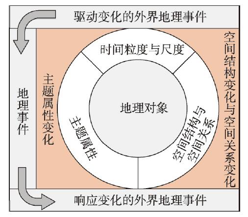
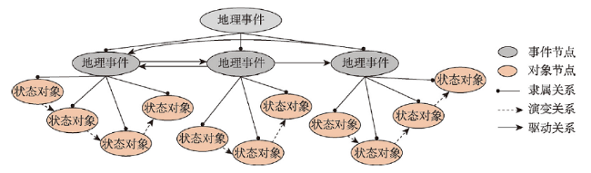
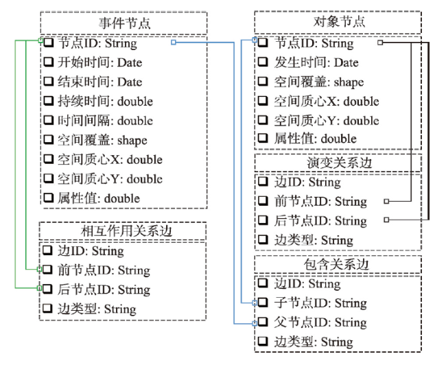
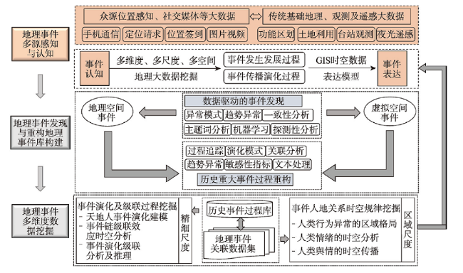
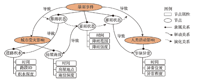
Geographic events, as a basic construct in geographic process description, have become a core content of geographic information system (GIS). Due to the limitation of acquiring human activity data, GIS modeling and analysis of geographic events has long been focused on the event-induced changes of geospatial objects and the interaction between the objects. However, in recent years, with the explosive growth of location-based service data and the rapid development of quantitative depiction of human activities, the impact of geographic events on human activities and online social participation in geographic events have aroused wide concern in many fields, which poses great challenges to the space-time cognition, modeling methods and analysis framework of geographic events. In this regard, this study discussed the conceptualization and categorization of geographic events in the context of big data, and then introduced the space-time semantics and graph-based data model for geographic events. The "node-edge" graph data structure is used to establish event ontology, the secondary or cascading events, the evolution process, and the "cause-effect" interaction. The spatiotemporal data mining approaches for geographical events were also summarized, which are limited to conventional event detection in "physical space". Integrating "virtual space" event discovery and propagation simulation ideas into data mining approaches is essential for recognizing multi-scale spatiotemporal responses and understanding regional difference of human activities under diverse geographic events. Finally, the study used urban rainstorm events as an example to examine the conceptualization and modeling method of geographic events. Social responses to urban rainstorms and regional differences were examined at inter-urban and intra-urban scales. The case study proved the concept and verified the feasibility and practicability of the proposed framework.
DU Yunyan , YI Jiawei , XUE Cunjin , QIAN Jiale , PEI Tao . Modeling and analysis of geographic events supported by multi-source geographic big data[J]. Acta Geographica Sinica, 2021 , 76(11) : 2853 -2866 . DOI: 10.11821/dlxb202111018
| [1] |
|
| [2] |
[周文, 刘宗田, 孔庆苹. 基于事件的知识处理研究综述. 计算机科学, 2008(2):160-162, 184.]
|
| [3] |
|
| [4] |
|
| [5] |
|
| [6] |
|
| [7] |
|
| [8] |
[谢盼, 王仰麟, 刘焱序, 等. 基于社会脆弱性的中国高温灾害人群健康风险评价. 地理学报, 2015, 70(7):1041-1051.]
|
| [9] |
|
| [10] |
|
| [11] |
|
| [12] |
|
| [13] |
|
| [14] |
|
| [15] |
|
| [16] |
[邓吉秋, 吴堑虹, 刘爱忠. 基于GIS逻辑信息法的SARS流行环境因素分析. 中国卫生统计, 2006, 23(4):301-305.]
|
| [17] |
|
| [18] |
[程昌秀, 史培军, 宋长青, 等. 地理大数据为地理复杂性研究提供新机遇. 地理学报, 2018, 73(8):1397-1406.]
|
| [19] |
[裴韬, 刘亚溪, 郭思慧, 等. 地理大数据挖掘的本质. 地理学报, 2019, 74(3):586-598.]
|
| [20] |
[周成虎. 大数据时代的空间数据价值: 《空间数据挖掘理论与应用》评介. 地理学报, 2016, 71(7):1281.]
|
| [21] |
|
| [22] |
|
| [23] |
|
| [24] |
|
| [25] |
|
| [26] |
|
| [27] |
|
| [28] |
|
| [29] |
|
| [30] |
|
| [31] |
|
| [32] |
|
| [33] |
|
| [34] |
|
| [35] |
|
| [36] |
|
| [37] |
|
| [38] |
|
| [39] |
[刘岳峰, 陆忞, 杨忠智. 时态GIS中动态网络建模及实现方法. 北京大学学报(自然科学版), 2012, 48(3):451-458.]
|
| [40] |
[张忠贵, 吴信才. 一种通用的网络时空数据模型. 计算机应用与软件, 2015, 32(9):84-87.]
|
| [41] |
|
| [42] |
[谢炯, 刘仁义, 刘南. 土地利用现状管理信息系统中土地利用多级变更模型的建立及其事务处理机制设计. 浙江大学学报(理学版), 2007(4):469-475.]
|
| [43] |
|
| [44] |
|
| [45] |
|
| [46] |
|
| [47] |
|
| [48] |
|
| [49] |
|
| [50] |
|
| [51] |
[刘瑜. 社会感知视角下的若干人文地理学基本问题再思考. 地理学报, 2016, 71(4):564-575.]
|
| [52] |
|
| [53] |
|
| [54] |
|
| [55] |
|
| [56] |
|
| [57] |
|
| [58] |
|
| [59] |
|
| [60] |
|
| [61] |
|
| [62] |
|
| [63] |
|
| [64] |
|
| [65] |
|
| [66] |
|
| [67] |
|
| [68] |
[易嘉伟, 王楠, 千家乐, 等. 基于大数据的极端暴雨事件下城市道路交通及人群活动时空响应. 地理学报, 2020, 75(3):497-508.]
|
| [69] |
|
/
| 〈 |
|
〉 |