
The recent evolution of dune landforms and its environmental indications in the mid-latitude desert area (Hexi Corridor)
Received date: 2020-07-29
Request revised date: 2021-07-15
Online published: 2022-01-25
Supported by
National Natural Science Foundation of China(41930640)
National Natural Science Foundation of China(41771014)
The Second Tibetan Plateau Scientific Expedition and Research(2019QZKK1003)
Copyright
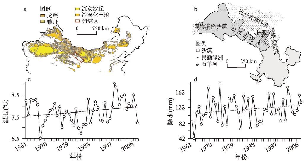
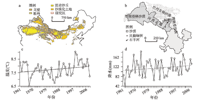
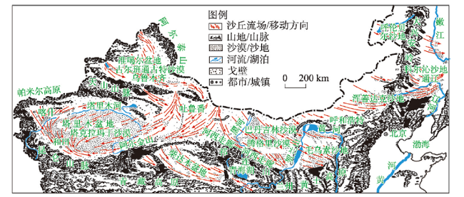
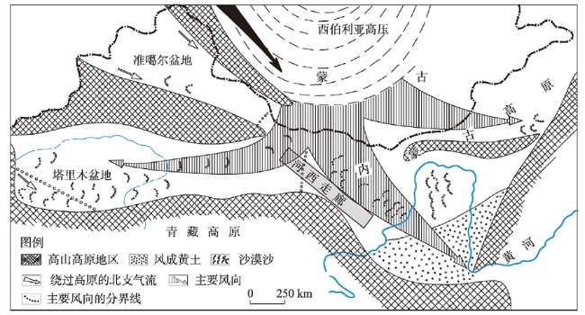
The history of dune landform changes and dust activity at mid-latitudes is a good archive for exploring environmental changes and related landscape response. In this study, the dynamic changes, material sources, dust activity history and the influencing factors of typical sand dunes in the Hexi Corridor were comprehensively analyzed from the aspects of aeolian geomorphology, grain-size sedimentology, geochemistry and climatology. The results show that in the past half century, the typical crescent-shaped dunes and chains of crescent-shaped dunes in the study area have moved or swayed greatly, with an average speed ranging from 0.8 m/a (Dunhuang) to 6.2 m/a (Minqin). The dynamic changes of sand dunes are mainly affected by annual precipitation, annual average wind speed and annual gale days, which indicates that climate is the primary influencing factor of dune landform changes. The three-stage grain-size curve model of dune sands is obviously different from that of gobi sediments (two-stage), revealing the "immaturity" of the latter in sedimentology, while the former has experienced efficiently aeolian differentiation and non-local origin. The comprehensive evidences of paleogeography, sedimentology and geochemistry reveal that the source materials of sand dunes are mainly alluvial/proluvial and palaeo-fluvial sediments, including clastic sediments in the denudation/erosion zones of the north and south piedmonts. Indicators such as the proportion of surface fine particles, the coverage of surface salt crusts, and the content of erodible sandy materials indicate that the western gobi areas are not the main source areas of wind-blown dust in the central and eastern parts of the Hexi Corridor. The spatial distribution of the movement direction of sand dunes is similar to that of the regional dominant wind direction, which indicates that the difference in the dynamic evolution of dune landforms between the east and west of the Hexi Corridor should be controlled by the regional-scale wind system, that is, controlled by the dynamic mechanism rather than the difference in material sources. The warming and humidification of the Hexi climate is a synchronous response to the global warming and the strengthening of the Asian Summer Monsoon. It is also the main reason for the reduction of dust storms in the study area, which means that a potential inverse desertification process exists in the Hexi Corridor during the same period and it is also controlled by climate change. However, the process of desertification in the oasis areas during the period is caused by groundwater fluctuation affected by human activities.
ZHU Bingqi . The recent evolution of dune landforms and its environmental indications in the mid-latitude desert area (Hexi Corridor)[J]. Acta Geographica Sinica, 2021 , 76(11) : 2710 -2729 . DOI: 10.11821/dlxb202111009
表1 河西走廊不同沙丘的地貌参数特征[20,21]Tab. 1 The locations, heights, movement directions, and lengths of different sand dunes in the Hexi Corridor[20,21] |
| 沙丘类型 | 沙丘编号 | 地理位置 | 沙丘高度(m) | 沙丘移动方向 (直角坐标系,正东向为0°) | 沙丘坡面长度(m) | ||
|---|---|---|---|---|---|---|---|
| 纬度(N) | 经度(E) | 迎风坡 | 背风坡 | ||||
| 新月型沙丘 | 1 | 38°37'52'' | 102°55'16'' | 9.8 | 48° | 438.5 | 252 |
| 2 | 38°38'00'' | 102°55'13'' | 11.2 | 48° | 163.3 | 492.7 | |
| 3 | 38°36'06'' | 102°55'05'' | 9.5 | 48° | 129.2 | 163.3 | |
| 4 | 38°37'51'' | 102°55'02'' | 3.7 | 48° | 304.2 | 484.1 | |
| 5 | 38°32'11'' | 102°56'34'' | 7.9 | 45° | 271.7 | 229.4 | |
| 6 | 38°31'59'' | 102°56'43'' | 7.6 | 46° | 762.3 | 430.1 | |
| 7 | 38°25'47'' | 102°54'37'' | 3.9 | 45° | 295.9 | 80.8 | |
| 8 | 38°25'17'' | 102°52'56'' | 5.9 | 87° | 42.6 | 52 | |
| 9 | 39°57'41'' | 98°49'44'' | 5 | 51° | 350.4 | 254.5 | |
| 10 | 39°58'07'' | 98°49'59'' | 2.6 | 54° | 222.8 | 437.9 | |
| 11 | 40°00'41'' | 98°49'18'' | 7.2 | 57° | 184.6 | 197.3 | |
| 新月型沙丘链 | 12 | 38°37'46'' | 102°54'53'' | 6.4 | 54° | 726.9 | 752.8 |
| 13 | 38°37'48'' | 102°55'55'' | 5.8 | 54° | 443.4 | 406.7 | |
| 14 | 38°37'24'' | 102°54'46'' | 11.1 | 50° | 794.8 | 658.4 | |
| 15 | 39°57'59'' | 98°51'17'' | 13.8 | 53° | 413.6 | 361.1 | |
| 16 | 39°57'31'' | 98°51'31'' | 8.7 | 54° | 501.8 | 466.2 | |
| 17 | 39°58'50'' | 98°48'04'' | 9.6 | 53° | 554 | 445 | |
| 金字塔型沙丘 | 18 | 40°05'16'' | 94°42'23'' | 25.8 | 西南—东北 | - | - |
| 19 | 40°05'14'' | 94°42'10'' | 90.3 | 西南—东北 | - | - | |
| 20 | 40°05'11'' | 94°41'47'' | 76.6 | 西南—东北 | - | - | |
| 21 | 40°05'11'' | 94°40'53'' | 121.8 | 西南—东北 | - | - | |
| 22 | 40°05'09'' | 94°40'43'' | 114.1 | 西南—东北 | - | - | |
| 23 | 40°05'24'' | 94°40'12'' | 88.9 | 西南—东北 | - | - | |
| 抛物线型沙丘 | 24 | 38°36'27'' | 102°57'15'' | 4.6 | - | 286.1 | 35.3 |
| 25 | 38°36'26'' | 102°57'42'' | 4.4 | - | 228.9 | 188 | |
| 26 | 38°36'10'' | 102°58'15'' | 3.3 | - | 133.3 | 198.5 | |
| 27 | 38°37'08'' | 93°59'40'' | 3.7 | - | 396 | 302.2 | |
| 28 | 41°35'64'' | 98°41'36'' | 4.4 | - | 59.9 | 0 | |
| 29 | 40°08'51'' | 98°41'20'' | 4.1 | - | 15.7 | 17.7 | |
| 积沙带(纵向沙沙垄) | 30 | 38°47'57'' | 103°12'36'' | 15.2 | - | 70.4 | - |
| 31 | 38°48'36'' | 103°13'30'' | 17.1 | - | 44 | - | |
| 32 | 39°02'12'' | 103°32'03'' | 18.6 | - | 811.7 | - | |
| 33 | 39°02'10'' | 103°31'29'' | 5.6 | - | 707.7 | - | |
| 34 | 39°02'34'' | 103.29'49'' | 12.2 | - | 1557.6 | - | |
| 35 | 39°02'20'' | 103°26'19'' | 9.4 | - | 207.1 | 223.4 | |
表2 河西走廊沙丘与其他沙漠风成沙或上陆壳平均组成的元素含量对比(%)Tab. 2 The average element contents of sandy dunes in the Hexi Corridor and other deserts and the average composition of the upper continental crust (%) |
| 地区 | Fe2O3 | CaO | MgO | SiO2 | Al2O3 | Na2O | K2O | 文献出处 |
|---|---|---|---|---|---|---|---|---|
| 河西走廊 | 3.5 | 5.55 | 2.07 | 66.12 | 9.24 | 2.45 | 2.00 | [39, 78] |
| 巴丹吉林沙漠 | 1.93 | 2.06 | 1.19 | 80.27 | 7.78 | 1.90 | 2.00 | [53] |
| 腾格里沙漠 | 1.96 | 1.30 | 1.12 | 80.94 | 8026 | 1.88 | 2.25 | [53] |
| 库姆塔格沙漠 | 2.88 | 4.64 | 2.19 | 70.13 | 9.59 | 2.52 | 1.98 | [81] |
| 塔克拉玛干沙漠 | 3.10 | 7.88 | 2.2 | 62.05 | 10.60 | 2.58 | 2.11 | [53] |
| 黄土高原黄土 | 4.56 | 8.62 | 2.31 | 58.65 | 11.86 | 1.68 | 2.44 | [81] |
| 黄土高原古土壤 | 5.12 | 0.83 | 2.21 | 65.18 | 14.79 | 1.41 | 3.15 | [81] |
| 上陆壳平均组成 | 5.00 | 4.20 | 2.22 | 66.00 | 15.20 | 3.90 | 3.40 | [42] |
| 陆相页岩 | 7.22 | 1.30 | 1.20 | 62.80 | 18.90 | 1.20 | 3.70 | [42] |
| [1] |
|
| [2] |
|
| [3] |
|
| [4] |
|
| [5] |
|
| [6] |
|
| [7] |
|
| [8] |
|
| [9] |
|
| [10] |
|
| [11] |
|
| [12] |
|
| [13] |
[朱震达, 王涛. 中国沙漠化研究的理论与实践. 第四纪研究, 1992(2):97-106.]
|
| [14] |
[张莉, 任国玉. 中国北方沙尘暴频数演化及其气候特征成因分析. 气象学报, 2003, 61(6):744-750.]
|
| [15] |
[濮仲远. 为了失去的绿洲—河西走廊历史时期的沙漠化研究评介. 中国历史地理论丛, 2005, 20(1):157-158.]
|
| [16] |
[李耀辉, 张书余. 我国沙尘暴特征及其与干旱关系的研究进展. 地球科学进展, 2007, 22(11):1169-1176.]
|
| [17] |
|
| [18] |
|
| [19] |
|
| [20] |
|
| [21] |
[常兆丰, 李亚, 张剑挥, 等. 新月形沙丘稳定性机理: 以甘肃河西沙区为例. 生态学报, 2017, 37(13):4375-4383.]
|
| [22] |
[郎丽丽, 王训明, 朱秉启, 等. 河西走廊西端灌丛沙丘发育过程及其对沙漠化的指示意义. 中国沙漠, 2017, 37(4):611-620.]
|
| [23] |
[张正偲, 董治宝. 黑河流域中游沙漠风能环境与风沙地貌. 中国沙漠, 2014, 34(2):332-341.]
|
| [24] |
|
| [25] |
[董治宝, 陈广庭, 颜长珍, 等. 塔里木沙漠石油公路沿线沙丘移动规律. 中国沙漠, 1998, 18(4):328-333.]
|
| [26] |
|
| [27] |
[何京丽, 郭建英, 邢恩德, 等. 黄河乌兰布和沙漠段沿岸风沙流结构与沙丘移动规律. 农业工程学报, 2012, 28(17):71-77.]
|
| [28] |
|
| [29] |
|
| [30] |
|
| [31] |
[毛东雷, 雷加强, 周杰, 等. 新疆策勒不同类型流动和半流动沙丘运移规律. 水土保持研究, 2016, 23(3):278-282.]
|
| [32] |
MDCES(Minqin Desert Control Experiment Station). Deserts and Control in Gansu. Lanzhou: Gansu People's Publishing house, 1975: 33-38.
[民勤治沙综合试验站. 甘肃沙漠与治理. 兰州: 甘肃人民出版社, 1975: 33-38.]
|
| [33] |
|
| [34] |
|
| [35] |
|
| [36] |
|
| [37] |
|
| [38] |
|
| [39] |
[潘凯佳, 张正偲, 董治宝, 等. 河西走廊新月形沙丘表层沉积物的理化性质. 中国沙漠, 2019, 39(1):44-51.]
|
| [40] |
|
| [41] |
|
| [42] |
|
| [43] |
|
| [44] |
|
| [45] |
|
| [46] |
|
| [47] |
|
| [48] |
|
| [49] |
|
| [50] |
|
| [51] |
|
| [52] |
|
| [53] |
|
| [54] |
|
| [55] |
|
| [56] |
[王力强, 王亲. 河西走廊地区及其毗邻地区地表物沉积元素特征. 西北地质, 2013, 46(2):69-80.]
|
| [57] |
[石学刚, 李广, 刘世增, 等. 河西走廊绿洲边缘新月形沙丘的动态变化及其与气象因子的关系. 甘肃农业大学学报, 2018, 2:86-93.]
|
| [58] |
[王涛. 中国沙漠与沙漠化. 石家庄: 河北科技出版社, 2003.]
|
| [59] |
|
| [60] |
|
| [61] |
[张克存, 屈建军, 俎瑞平, 等. 不同下垫面对风沙流特性影响的风洞模拟研究. 干旱区地理, 2004, 37(3):352-355.]
|
| [62] |
[屈建军, 黄宁, 拓万全, 等. 戈壁风沙流结构特性及其意义. 地球科学进展, 2005, 20(1):19-23.]
|
| [63] |
[王训明, 郎丽丽, 花婷, 等. 戈壁砾石覆盖度与风蚀强度关系实验研究. 中国沙漠, 2013, 33(2):313-319.]
|
| [64] |
[殷代英, 屈建军, 俎瑞平, 等. 不同扰动方式对沙砾质戈壁地表风蚀量的影响. 中国沙漠, 2014, 34(1):1-8.]
|
| [65] |
[安富博, 张德魁, 赵锦梅, 等. 河西走廊不同类型戈壁土壤理化性质分析. 中国水土保持, 2019, 6:42-47.]
|
| [66] |
[常兆丰. 甘肃河西60年防沙治沙的问题及出路. 干旱区资源与环境, 2019, 33(9):152-159.]
|
| [67] |
[胡菲, 张克存, 安志山, 等. 敦煌沙漠、绿洲和戈壁地表风动力环境特征同步对比. 中国沙漠, 2020, 40(4):113-119.]
|
| [68] |
[任孝宗, 刘陶, 王振亭. 河西沙区新月形沙丘形态参数观测. 水土保持研究, 2010, 17(1):163-166.]
|
| [69] |
|
| [70] |
|
| [71] |
|
| [72] |
|
| [73] |
[任孝宗. [王振亭. 民勤绿洲沙源分析. 宁夏大学学报自然科学版, 2010, 31(1):88-92.]
|
| [74] |
[王立强. 河西走廊及其毗邻地区地表沉积与亚洲粉尘源区示踪[D]. 兰州:兰州大学, 2011.]
|
| [75] |
|
| [76] |
|
| [77] |
[任孝宗. 民勤绿洲及其毗邻沙漠流动沙丘表面沉积物的元素分析[D]. 兰州: 兰州大学, 2010.]
|
| [78] |
|
| [79] |
[李恩菊. 巴丹吉林沙漠与腾格里沙漠沉积物特征的对比研究[D]. 西安: 陕西师范大学, 2011.]
|
| [80] |
|
| [81] |
[董治宝, 苏志珠, 钱广强. 库姆塔格沙漠风沙地貌. 北京: 科学出版社, 2011.]
|
| [82] |
[颉耀文, 陈发虎, 王乃昂. 近2000年来甘肃民勤盆地绿洲的空间变化. 地理学报, 2004, 59(5):662-670.]
|
| [83] |
|
| [84] |
|
| [85] |
|
| [86] |
|
| [87] |
[常兆丰, 韩福贵, 仲生年, 等. 石羊河下游沙漠化的自然因素和人为因素及其位移. 干旱区地理, 2005, 28(2):150-155.]
|
| [88] |
[李并成. 石羊河下游绿洲早在唐代中期就已演变成了”第二个楼兰”. 开发研究, 2007, 2:153-157.]
|
| [89] |
|
| [90] |
|
| [91] |
|
| [92] |
|
| [93] |
|
| [94] |
|
| [95] |
|
| [96] |
|
| [97] |
|
| [98] |
|
| [99] |
[常兆丰, 韩福贵, 仲生年. 民勤荒漠区气候变化对全球变暖的响应. 中国沙漠, 2011, 31(2):505-510.]
|
| [100] |
|
| [101] |
|
| [102] |
[沙万英, 邵雪梅, 黄玫. 20世纪80年代以来中国的气候变暖及其对自然区域界限的影响. 中国科学D辑, 2002, 32(4):317-326.]
|
| [103] |
[丁一汇. 中国西部环境变化的预测//秦大河. 中国西部环境演变评估. 北京: 科学出版社, 2002.]
|
| [104] |
[常兆丰, 马中华, 王大为, 等. 民勤荒漠气候变化的不稳定性研究. 干旱区研究, 2016, 33(3):601-608.]
|
| [105] |
|
| [106] |
|
| [107] |
|
| [108] |
[
|
| [110] |
|
| [111] |
[常兆丰, 刘虎俊. 甘肃省河西内陆河流域荒漠化防治(II). 防护林科技, 2003, 2:28-32.]
|
/
| 〈 |
|
〉 |