Climate Change and Land Surface Process

Atmospheric dust deposition history over the past 150 a recorded by mountain peatlands in northeast China

  • BAO Kunshan , 1 ,
  • YANG Ting 1 ,
  • XIAO Xiang 1 ,
  • JIA Lin 2 ,
  • WANG Guoping 3 ,
  • SHEN Ji 4
Expand
  • 1. School of Geography, South China Normal University, Guangzhou 510631, China
  • 2. Beijing Key Laboratory for risk modeling and remediation of contaminated sites, National Engineering Research Center of Urban Environmental Pollution Control, Beijing Municipal Research Institute of Environmental Protection,Beijing 100037, China
  • 3. Northeast Institute of Geography and Agroecology, CAS, Changchun 130102, China
  • 4. School of Geography and Ocean Science, Nanjing University, Nanjing 210023, China

Received date: 2019-12-31

  Request revised date: 2021-04-20

  Online published: 2021-11-25

Supported by

National Natural Science Foundation of China(41971113)

Copyright

Copyright reserved © 2021

Abstract

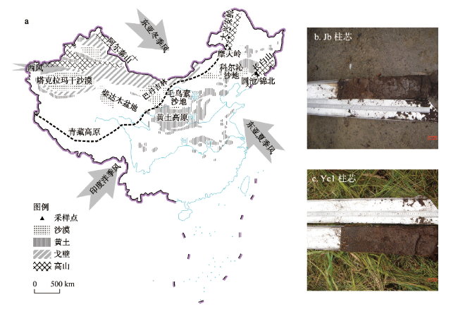
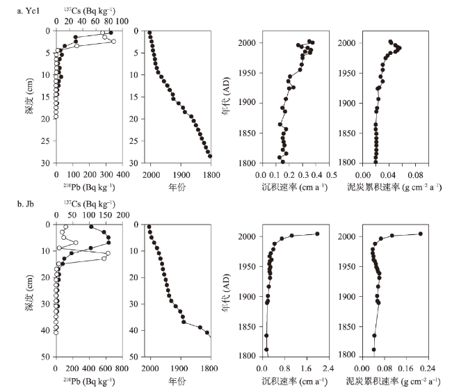
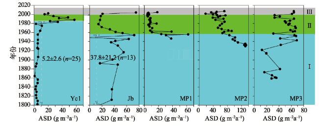
In order to investigate the past 150-year history of atmospheric dust deposition and its effect on the Asian monsoon zone and marginal zone, ombrotrophic peats from the Changbai Mountians were used to reconstruct the past history of atmospheric dust deposition based on the grain-size, lithogenic elements and 210Pb and137Cs dating. The dust deposition sequences were compared with those from Motianling peat of Great Hinggan Mountains. The mountain peat ash in northeast China was mainly composed of clay and silt. The medium grain size and the lithogenic elemental fingerprints also preliminarily revealed that the mineral dust in the mountain peat of northeast China were mainly from the soil dust in Mongolian and northern China desert and sand land areas. The atmospheric soil dust deposition flux increased gradually from the 1800s to the 1960s, which was consistent with the increase of human activities such as regional modernization, industrialization and aggressive wars. There was a decreasing trend in the atmospheric soil dust deposition during the past 60 years in northeast China, as shown by the mountain peat records, which is in good agreement with the monitoring data of regional natural dust storms. The background baseline of the long-distance atmospheric soil dust deposition flux in northeast China is calculated as 5.2±2.6 g m-2 a-1. The mean atmospheric soil dust flux was 5-38 g m-2 a-1 in the Changbai Mountain area, and that value was 14-68 g m-2 a-1 in the Great Hinggan Mountain area. The atmospheric dust deposition rates derived from the Changbai Mountain peat were smaller than those derived from the Great Hinggan Mountian peat. This suggested a decreasing atmospheric dust deposition with the increasing distance from the dust source area, and thus the influence extent of atmospheric dust deposition on the western side was higher than that on the eastern side of northeast China.

Cite this article

BAO Kunshan , YANG Ting , XIAO Xiang , JIA Lin , WANG Guoping , SHEN Ji . Atmospheric dust deposition history over the past 150 a recorded by mountain peatlands in northeast China[J]. Acta Geographica Sinica, 2021 , 76(9) : 2283 -2296 . DOI: 10.11821/dlxb202109017

1 引言

矿物粉尘(Mineral Dust)一般被认为是干旱多风气候的产物,对大气圈物质组分和辐射平衡有重要影响,同时还是生态营养和环境污染物质的主要携带者[1]。近年来,有关全球粉尘源区分布、粉尘循环过程(释放、传输和沉降)及尘暴演化特征等研究成为热点话题。亚洲是一个重要的粉尘源区,源于蒙古国和中国西北干旱地区的矿物粉尘,经长距离搬运,对周边国家造成影响,已经引起韩国、日本和美国等的关注[2]。一直以来,中国高分辨率的粉尘地质记录和季风演化研究主要集中在西北[3,4]、西南[5,6]以及南方地区[7,8]。这些区域黄土、冰芯和湖泊沉积物记录的大气降尘历史为全新世气候波动和季风演变研究提供了重要信息[9,10,11]。而东北位于北方沙漠与沙地东部边缘,离粉尘源区较近;它又受到亚洲季风和高空西风环流的影响(图1),在地质和人类历史时期频繁出现沙尘暴天气。但是,有关长时间尺度的大气粉尘记录及其对大气环流变化的响应研究相对较少[12,13,14]
图1 中国北方干旱区域及东北地区泥炭采样点位置示意图

注:基于自然资源部标准地图服务网站GS(2019)1671号标准地图制作,底图边界无修改;图b、图c由王国平摄;箭头为东亚季风环流系统示意,黑色虚线指示现代亚洲夏季风边界[25]

Fig. 1 The drylands in northern China, the location of peat sampling points and the peat cores photos

泥炭地是一个记录大气环境变化的积极信息储备体,在古气候环境变化综合判识与恢复方面有一定优势[15,16]。泥炭有机质含量高、堆积速率快、连续发育,因此便于精确定年、获得高分辨率序列。泥炭藓能够有效捕获粉尘,特别是高山雨养泥炭,其营养物质主要来自于大气沉降,是重建大气粉尘输入历史的理想材料[17]。泥炭地分布比其它地质载体广泛,可出现在不同类型的地理单元,有可能解决目前粉尘序列数据库空间覆盖度较低且分布不均的难题。在欧美已经开展了很多利用泥炭重建过去千年尺度的大气降尘历史研究,主要利用元素地球化学手段进行降尘通量的估算,结合孢粉等生物遗存指标进行古气候重建,分离稀土元素及其同位素进行降尘来源的指纹判别[18,19,20,21,22]。国内的相关研究也陆续展开。西南地区高原泥炭和东北地区高山泥炭是目前国内研究较多的大气沉降档案。利用西南红原泥炭重建了9.5 ka的大气Pb同位素记录,发现该地区的全新世Pb沉降受到了远源沙尘输入影响,对东亚冬季风变化具有很好的指示意义[23]。利用大兴安岭摩天岭泥炭的Ti等地球化学元素记录重建了过去150 a来自然尘暴演化历史,发现大气土壤尘降(ASD)通量在过去60 a来表现出减小趋势,与过去50 a中国北方地区气象站监测的沙尘暴变化规律一致[14]。利用长白山哈尼泥炭地球化学元素、矿物和粒度等多指标重建了14 ka的大气粉尘沉降历史,揭示了东亚季风和西风环流的交互作用对矿物粉尘传输的影响机制,增进了中国大气粉尘与气候变化关系研究的认识[24]
大兴安岭、长白山地区地区属于中高纬山区,气候相对寒冷、高湿,发育有较好的亚高山泥炭沼泽,分布比较广泛(图1)。迄今为止,人类活动对这些边远山区的直接影响较小。这些区域的山地泥炭沼泽,是获取自然环境变化信息的理想档案[14, 24]图1)。大兴安岭地处东亚季风边缘,年均降水量约400 mm。长白山地位于东亚夏季风影响区,年降水量700~1400 mm。因此,大气粉尘对季风边缘区和季风影响区的影响差异如何?过去150 a来大气粉尘沉降历史是如何变化的?为了回答这2个科学问题,本文选择长白山典型雨养泥炭为研究对象,剖析泥炭中灰分含量、成岩化学元素、粒度记录,结合210Pb和137Cs年代等指标重建过去150 a来大气粉尘变化历史,并与大兴安岭摩天岭雨养泥炭粉尘记录进行比较研究,揭示东亚季风梯度下大气粉尘对长白山和大兴安岭的影响规律。

2 材料与方法

2.1 研究区域及样品采集

长白山地区泥炭沼泽主要是通过森林和草甸沼泽演替以及水体沼泽化过程形成。圆池泥炭沼泽位于长白山主峰东侧30 km处,由息火口湖逐步演变而成。圆池周围为沼泽化森林,植被类型主要包括落叶松(Larix Sp.)、杜香(Ledum Palustre)、泥炭藓(Sphagnum)、小叶杜鹃(Rhododendron Capitatum)、毛苔草(Carex Lasiocarpa)和芦苇(Phragmites Australis)等[26]。圆池泥炭沼泽海拔约为1200 m,年均降雨1000 mm。锦北泥炭沼泽位于长白山西北麓,属于玄武岩台地区,海拔约为900 m,年均降雨约900 mm,年均温为2~5 ℃。锦北泥炭沼泽区的主要植物类型包括为落叶松、笃斯越桔(Vaccinium uliginosum)和泥炭藓[27]
2005年9月初,利用荷兰Wardenaar泥炭采样器在长白山圆池西部(42°01′54″N、128°26′02″E,海拔1281 m;Yc1)和锦北(41°58′43″N、127°37′17″E,海拔909 m;Jb)采集2个泥炭柱芯,深度分别为50 cm和54 cm(图1[27,28]。在采样现场使用不锈钢面包刀切割泥炭柱芯,切割精度为1 cm(Yc1)或2 cm(Jb)。每层样品装入自封袋中,带回实验室后在-18 ℃下冷冻保存备用。利用210Pb和137Cs测年,对上部层位(Yc1:29 cm、Jb:44 cm)重建了过去150 a环境演变历史[29,30],分析经210Pb和137Cs测年的29 cm(Yc1)和44 cm(Jb)泥炭记录。

2.2 实验分析

2.2.1 基本理化指标分析 将一定体积的样品105 ℃烘干12 h至恒重,烘干前后质量差除以湿样质量得到样品的含水量(%),干样质量除以容器体积得到干容重(g cm-3)。将一定质量的烘干样品继续在(700±25) ℃马福炉中完全燃烧4 h,使灰烬灼烧至恒重。灰烬质量与干样质量之比即为泥炭灰分含量(%)[29,30],相关结果如图2
图2 长白山泥炭化学元素随时间变化特征

注:图中I、II、III分别表示泥炭灰分和地壳元素缓慢增长阶段、明显减小阶段和21世纪后潜在增加阶段;研究区邻近区域龙凤山降水的Ca/Mg摩尔比均值为4.10[38,39]

Fig. 2 Temporal variations of chemical elements for the peat cores from Changbai Mountains, northeast China

利用灰化样品的弱酸不可溶物进行粒度分析,是泥炭粒度分析的常用方法,能够较准确反演大气土壤尘降通量和来源变化[24, 31-35]。首先,向烧杯中添加适量上述灰分样品,加入10 mL盐酸(10%),将钙质成分完全溶解掉。静止5~6 h后,向烧杯中加入10 mL六偏磷酸钠(3.4%),以使颗粒物充分分散。然后,将烧杯放入超声波池中震荡10 min,在1 h内利用激光粒度仪(Mastersizer 2000,英国)测试震荡后的样品粒度,重复测量误差小于3%。测试结果按< 4 µm、4~63 µm和> 63 µm的颗粒分为黏土、粉砂和砂粒。
2.2.2 210Pb和137Cs测年 在中科院南京地理与湖泊研究所湖泊与环境国家重点实验室进行210Pb和137Cs放射性比活度测试。测试样品为约7 g用玛瑙研钵研磨均匀的烘干样(105 ℃烘12 h)。测试仪器为γ谱分析系统,主要由美国EG&G Ortec公司生产的高纯锗井型探测器(Ortec HPGe GWL)与Ortec919型谱控制器组成。210Pb标准样品由英国利物浦大学做比对标准;137Cs和226Ra标准样品由中国原子能研究院提供。泥炭柱芯的沉积年代和累积速率通过恒定放射性通量模式(Constant Rate of 210Pb Supply model, CRS)计算[29,30],相关结果如图3
图3 放射性210Pb和137Cs比活度、年代—深度模型、沉积速率和泥炭积累速率变化

注:数据来自文献[29,30]。

Fig. 3 Depth variations of 210Pb and 137Cs activities, age-depth models and temporal variations of sediment rate (SR) and peat accumulation rate (PAR)

2.2.3 化学元素测定 用电子天平称取灰化样品0.500 g,置于硝酸溶液洗过的聚四氟乙烯离心管中,加入2~3 mL去离子水湿润样品,加入5 mL 0.5N HCl 溶液消解,并用水浴振荡器振荡16 h。之后进行HNO3-HF-HClO4(10:2:1)混合酸消解,采用铁板沙浴(180±5) ℃加热5 h。待冷却后加入少量去离子水至15 mL溶液,然后高速离心15 min(4000 rmp),上层溶液转移至25 mL容量瓶中用去离子水定容待测。详细的元素分析结果和质量控制参见以前的文献报道[27-29]。

2.3 大气土壤尘降通量计算

雨养泥炭主要由有机质、矿物质和腐殖质组成,其中矿物质主要来自大气降尘[36]。因此,基于泥炭地壳元素记录计算大气土壤尘降通量可以分2步:① 计算泥炭中土壤尘的浓度,因为土壤尘中Ti的浓度等于地壳中Ti的丰度(0.40%),所以将泥炭中Ti的含量除以矿物质土壤尘Ti的浓度,即换算出泥炭中土壤尘的浓度(公式(1));② 根据土壤尘的浓度和沉积速率计算土壤尘输入速率[37](公式(2))。
CSD = Ti × ASH × 250
ASD = CSD × DBD × SD
式中:CSD为土壤尘浓度 ( µg g - 1 );Ti为矿物质土壤尘浓度(µg g-1);ASD为大气土壤尘降通量 ( µgc m - 2 a - 1 );ASH为泥炭灰分含量 ( 0.40 % );DBD为泥炭干容重 ( gc m - 3 ),SD为泥炭沉积速率 ( cm a - 1 )
前人研究中利用泥炭全样测试Ti元素浓度[37],而本文中利用泥炭灰测得Ti的含量,因此,在利用前人的计算公式时略作修改,即通过泥炭灰分含量校正Ti的浓度。本方法已经应用于大兴安岭摩天岭雨养泥炭大气尘降记录研究中[14]

3 结果分析

3.1 长白山泥炭粒度特征

长白山2个柱芯的泥炭灰分粒度组成表明:长白山泥炭矿物组分主要以粉砂颗粒为主,达到74%,而且在过去150 a来随时间变化较小;其次是黏土组分,占比约为15%;粗颗粒砂组分约占10%(图4)。黏土和砂组分都随时间发生了变化。对于Yc1柱芯,自20世纪70年代以来黏土含量逐渐减小,而砂颗粒逐渐增大。对于Jb柱芯,可以观察到砂组分在20世纪70年代以来和21世纪初均呈现峰值;自20世纪初—20世纪70年代和20世纪70年代—21世纪初,砂组分逐渐增大,黏土相应地逐渐减小。2个泥炭柱芯的中值粒径的历史变化趋势与砂组分的变化态势一致。Yc1柱芯在19世纪初—20世纪70年代间,中值粒径为(13.7±2.4) µm;Jb柱芯在19世纪初—20世纪初,中值粒径保持较稳定,为(9.3±0.8) µm。
图4 长白山泥炭灰分粒度组成随时间变化特征

注:图中1、2阶段分别为砂组分增加、黏土减小阶段。

Fig. 4 Temporal variations of grain-size for the peat cores from the Changbai Mountains, northeast China

3.2 长白山泥炭化学元素分布特征

长白山2个泥炭柱芯的化学元素(K、Na、Ca、Mg、Ti、V)分析结果如图2所示。对于每个柱芯,这6种元素记录均表现出一致的变化趋势,与灰分含量吻合较好。对于2个柱芯间的比较,Yc1的元素峰值出现在20世纪90年代,而Jb的元素峰值出现在20世纪60年代。Yc1的元素含量自20世纪90年代—21世纪初逐渐减小;Jb的元素含量自20世纪60年代—21世纪初逐渐减小,持续时间较长。泥炭中Ca与Mg的摩尔比值与泥炭干容重的时间变化保持一致。Yc1柱芯的大部分层位Ca与Mg摩尔比小于4,Jb柱芯的全部样品的比值都小于4。

3.3 长白山泥炭记录的大气尘降通量

长白山圆池(Yc1)和锦北(Jb)泥炭沼泽远离交通运输线路,而且周围植被覆盖较好,利用这些柱芯记录来计算大气土壤尘降通量(ASD),定量研究区域尘暴演化历史(图5)。19世纪初—20世纪80年代Yc1剖面的ASD比较稳定,平均值为(5.2±2.6) g m-2 a-1,可以作为长距离大气土壤尘降的背景基线;ASD峰值出现在20世纪90年代,之后出现减小趋势。Jb剖面在19世纪初—20世纪60年代间,ASD呈现波动变化中逐渐增加趋势,平均为(37.8±21.2) g m-2 a-1;自20世纪60年代—21世纪初,ASD逐渐减小。在21世纪初后,2个柱芯记录的ASD均有增加趋势。由于粒度组分表明该泥炭剖面在近地表层粗颗粒增加,很可能受到地表土壤侵蚀影响,不用于估算大气土壤尘降通量。因此,长白山地区外源大气土壤尘降通量为5~38 g m-2 a-1
图5 长白山地泥炭记录的大气尘降通量历史变化及其与大兴安岭摩天岭泥炭记录比较

注:大兴安岭摩天岭泥炭记录数据来自文献[14];绿色部分为气象记录的中国北方近50年沙尘暴减少时期[40];图中I、II、III分别表示大气土壤尘降通量缓慢增长阶段、明显减小阶段和潜在增加阶段。

Fig. 5 Comparisons of accumulation rate of atmospheric soil dust calculated from the Changbai Mountain peatlands and the Motianling peat records in Great Hinggan Mountains

4 讨论

泥炭沼泽是有泥炭形成和积累的原地自沉积载体,是过去环境变化的良好地质档案之一[16, 36]。它根据水分和营养物质来源,主要分为以大气降水补给为主的雨养泥炭沼泽和以地下水补给为主的矿养泥炭沼泽。通过比较泥炭和区域降水中Ca/Mg摩尔比,可以有效区分矿养泥炭和雨养泥炭;雨养泥炭中Ca/Mg比接近或小于区域降水的比值,而如果泥炭中Ca/Mg比值大于区域降水的比值,则表明有非大气来源的Ca输入到泥炭中[41]。长白山圆池(Yc1)和锦北(Jb)泥炭已经被报道为山地雨养泥炭,其营养物质来源特征主要为大气沉降[27, 29]。本文图2也显示,泥炭样品中Ca与Mg的摩尔比值小于当地龙凤山降水的比值(4.10)[38,39]。这进一步说明了Yc1和Jb泥炭为雨养泥炭沼泽。本文重点对这2个泥炭柱芯进行粉尘记录分析。
长白山2个泥炭柱芯沉积物含有较低的砂质组分和较高的粘土与粉砂颗粒物(图1)。它们的粒度分布进行聚类分析,能够划分出3类峰型,主要是单峰、多峰和偏峰模式(图6)。这些粒度分布特征与长白山地区哈尼泥炭和大牛沟泥炭以及大兴安岭摩天岭泥炭记录一致,与长白山区大气降尘和哈尔滨市大气降尘监测数据也是吻合的。大兴安岭摩天岭泥炭灰分主要是由粉砂颗粒组成(65%~74%),还有砂颗粒组分(约13%)和黏土组分(12%~22%)[42]。这些泥炭地中3种组分含量都大体相当,粒度组成比较一致。长白山Yc1和Jb泥炭粒度中值粒径为9~14 µm,与长白山哈尼泥炭((10.5±1.9) µm)[24],长白山大气降尘(12~17 µm)[43]和哈尔滨市大气降尘(约12.1 µm)[44]比较一致。由于风蚀作用能够携带悬浮细颗粒物进行远距离传输[45],上述比较说明泥炭中这些粘土—粉砂颗粒物组分主要源于风尘沉积,而且是来自相同的尘源区。
图6 通过聚类分析划分的长白山泥炭3种粒度分布模式及其与附近区域大气降尘的粒度分布比较

注:不同颜色泥炭记录代表不同柱芯中典型样品粒度分布;不同颜色降尘记录代表不同时间的现代沙尘天气。

Fig. 6 Grainsize distributions of the Changbai Mountain peat obtained from the clustering analysis and comparison with the distribution of the near places

中国源区粉尘的元素示踪系统显示,在中国沙漠大气中Al、Ca、Fe、Mg、Mn、Ti等元素源于沙漠粉尘,是可选择的示踪元素[46]表1中总结了长白山和大兴安岭泥炭样品中上述地壳元素的浓度均值,以及中国北方干旱半干旱地区表层土壤和土壤气溶胶中这些元素含量。亚洲主要沙尘源区有塔克拉玛干沙漠和蒙古国南部戈壁沙漠,这些区域的大量沙尘被风扬起,在大气环流作用下迁移至下风向地区[47]。如图1所示,干冷的亚洲冬季风搬运的粉尘堆积形成了中国的黄土高原[48]。黄土中Al、Ca、Fe、Mg、Mn、Ti等元素含量与本文中长白山泥炭中这些地壳来源元素含量具有一致性;巴丹吉林沙漠、兰州市和北京市采集的气溶胶分析中的相应元素含量与长白山泥炭中这些地壳来源元素含量也是可比较的(表1)。因而说明亚洲季风输入大气降尘很可能是长白山泥炭中的矿物颗粒的主要来源。这印证了前人的研究结果:长白山地区的土壤在成土过程中受到了来自中国和蒙古干旱半干旱地区对流层风尘的影响[49]。长白山泥炭中小颗粒组分(< 37 µm)被认为是东亚冬季风的敏感代用指标[43]。长白山地和大兴安岭摩天岭都是终年盛行偏西风,而摩天岭正好位于高空风尘传往长白山甚至日本海的路径上,因此大兴安岭摩天岭地区也长期受到来自西部蒙古国和中国干旱半干旱地区的风尘沉降的影响。
表1 东北泥炭中成岩元素与中国北方干旱半干旱地区表层土壤和气溶胶中元素含量比较

Tab. 1 Comparison of lithosphere metals in peat taken from northeast China Mountains, surface soils and dust aerosols of arid and semi-arid areas of northern China

样品 区域 铝(%) 钙(%) 铁(%) 锰(mg g-1) 钒(mg kg-1) 钛(mg g-1) 数据来源
泥炭 长白山地区 0.5~2.3 1.2 0.2~0.9 0~0.2 0~33.9 0.1~1.7 [27, 29]
泥炭 大兴安岭 2.9~5.9 4.1~6.2 2.4~3.8 1.0~2.3 87.7~123.9 1.6~4.3 [14]
表土 塔克拉玛干沙漠 5.0~5.3 6.3~6.6 2.1~2.3 0.5 - 0.3 [58]
表土 戈壁沙漠 6.0 2.8 3.0 0.6 - 0.4 [58]
表土 黄土区域 5.3~6.0 4.8~5.1 2.5~2.9 0.5~0.7 - 0.3 [58]
粉尘气溶胶 巴丹吉林沙漠 7.0 7.0 4.0 2.0 - 0.5 [47]
粉尘气溶胶 北京 8.6 - 2.4 1.0 95.0 - [59]
粉尘气溶胶 兰州 4.6 5.13 2.6 0.7 99.0 3.4 [60]

注:“-”表示无数据。

大兴安岭摩天岭泥炭也在过去研究中揭示出该泥炭地剖面具有典型雨养—矿养泥炭分层,已经重建了过去60 a来大兴安岭地区大气尘降通量变化历史[14],本文中将其雨养泥炭层位记录的大气尘降通量变化历史与长白山泥炭粉尘通量记录进行比较(图5)。在20世纪50年代前,Yc1柱芯大气土壤尘降通量比较小而稳定,Jb和MP3柱芯显示的大气土壤尘降通量均表现出一致的增加趋势,与晚清(1840—1912年)以来,区域社会发展和人类活动影响强度增强保持一致。20世纪50年代至21世纪初,大气土壤尘降通量均表现出减小的态势。1954—2002年中国北方地区有沙尘暴记录的气象站的监测数据揭示,过去50 a中国北方沙尘暴表现出明显的减小趋势[40]。长白山泥炭重建的大气土壤尘降通量过去60 a变化规律与大兴安岭泥炭记录和气象站尘暴资料是吻合的。也有利用冰芯和湖泊沉积物记录重建中国北方20世纪沙尘变化天气的研究,这些研究报道的中国北方20世纪沙尘天气的发生频率呈减小趋势[6]与本文结果一致。这些比较说明本文基于山地泥炭重建的大气粉尘沉降历史是可靠的。需要注意的是,Yc1泥炭记录的大气土壤尘降通量峰值时间要滞后30余年(图5)。这可能是由于Jb泥炭海拔较Yc1低,受局地输入的影响较Yc1大。而这2个点位的降水量相差不大,分别为900 mm a-1(Jb)和1000 mm a-1(Yc1),因此可以认为局地输入主要由于人为活动造成。而低海拔区的Jb受到森林砍伐和农业开垦等人类活动影响时间更早、强度更大,导致当地土壤侵蚀而逐渐增加了粗颗粒物质输入[50]。Jb泥炭的砂组分和中值粒径在20世纪初至20世纪70年代逐渐增加(图3),也说明了这一问题。而Yc1所处海拔较高,一直以来主要接受高空粉尘,对当地人类活动引起的土壤侵蚀过程响应滞后。基于Yc1泥炭柱芯粉尘记录计算的ASD值((5.2±2.6) g m-2 a-1),可以作为东北地区长距离输入的大气土壤尘降通量的背景基线。
通过泥炭档案估算出了长白山地区外源大气土壤尘降通量为5~38 g m-2 a-1;大兴安岭摩天岭大气尘降通量为14~68 g m-2 a-1图5)。总体来看,两个地区的自然土壤尘降通量大小在数量级上具有较好的一致性(表2)。但是,大兴安岭地区在东北地区西部,比长白山地区更接近粉尘源区,依然能观察到其大气尘降通量稍微偏大。泥炭粒度分布特征和成岩化学元素指纹揭示了相同的尘降来源,均受到来自蒙古国和中国干旱半干旱地区的风蚀土壤矿物输入的影响,因此,2个地区的大气尘降通量大小差异说明了这种长距离大气粉尘输入对东北地区西部环境的影响更加明显。将本文的结果与东亚、西亚、南美和大洋洲过去的相关研究数据进行比较(表2),可以看出大气粉尘沉降通量数据相互吻合度较好。在比对分析过程中,需要注意的是:研究区域和试验方法的差异对大气尘降通量的估算会有一定的影响[51]。例如,中国北方农牧交错带的奈曼地区沙漠化发生和发展较为典型,是北方沙尘的主要尘源地[52],其大气尘降通量就比本文的结果大。除了与粉尘源区进行比较外,选择起源于中国北方和蒙古国干旱区戈壁沙漠的亚洲尘暴的下风向传输路径上的中国渤海、韩国釜山区域和日本札幌市进行比较,发现本文结果与中国渤海的大气尘降通量[53]和韩国釜山区域(Busan Gijiang-gun)的大气尘降通量相当[54],但是大于日本札幌市(Sapporo)区域的大气尘降通量[55]。这揭示了大气粉尘沉降速率具有随着距离尘源区域愈远而逐渐减小的趋势。此外,在南美阿根廷西南部潘帕斯草原(Pampa)[51]、西亚死海地区[56]、大洋洲的澳大利亚东部[57]通过直接气象监测的方法报道了相应的大气尘降通量监测数据,与本文基于泥炭地球化学重建的过去大气粉尘沉降通量是可比较的。因此,通过泥炭档案反演大气尘降通量是区域大气颗粒直接监测长期实验的一种有效的替代方法,能够减小直接监测实验的工作量,延长大气尘降通量的时间尺度,克服监测站点有限性等问题。
表2 全球不同区域大气尘降平均通量比较

Tab. 2 Comparison of annual aeolian dust deposition rate in a worldwide context

区域 采样点 研究方法 年份 大气尘降通量(g m-2 a-1) 数据来源
中国 长白山地区 泥炭档案 1800—1970s 5.2~37.8 本研究
中国 大兴安岭 泥炭档案 1860—2009 13.4~68.1 [14]
中国 科尔沁奈曼 直接监测 2001—2002 257.3 [52]
中国 渤海 直接监测 1987—1992 26.4 [53]
韩国 釜山 直接监测 2002 10~77 [54]
日本 札幌市 直接监测 1994—1995 5.2 [55]
阿根廷 潘帕斯草原 直接监测 1993—1995 40~80 [51]
西亚 死海 直接监测 1997—1999 25.5~60.5 [56]
澳大利亚 澳大利亚东部 气象资料 1957—1984 31.4~43.8 [57]

5 结论

(1)应用放射性同位素210Pb和137Cs技术和元素地球化学方法,以大气土壤尘降通量(ASD)为指纹参数重建了东北地区过去150 a来大气尘暴演化历史。自19世纪初至19世纪60年代,伴随着区域近代化、工业化和战争,ASD表现出逐渐增加的趋势。而在过去60 a间ASD表现出逐渐减小的趋势,这与过去50 a中国北方的沙尘暴气象记录数据吻合较好。基于雨养泥炭的年代学和地球化学记录重建过去大气尘降通量变化历史,是区域沙尘直接气象监测和历史文献记录的良好补充。
(2)东北山地泥炭灰分中粘土颗粒和粉砂颗粒物为主,砂粒组分含量相对较小。泥炭柱芯中砂级组分和中值粒径在近表层位表现出增加趋势,揭示了东北山区环境受到城市扩张等多种人为活动的影响作用扩大。粒度分布曲线的双峰模态也指示了远源大气降尘和近源土壤侵蚀输入对泥炭沼泽沉积的影响。粒度特征和典型成岩元素含量指纹也初步揭示东北山地泥炭中矿物灰分主要源于蒙古国和中国北方沙漠和沙地的土壤尘。
(3)东北地区长距离传输的ASD背景基线为(5.2±2.6) g m-2 a-1,长白山地区ASD为5~38 g m-2 a-1;大兴安岭地区ASD为14~68 g m-2 a-1。这些重建的大气土壤尘降通量与全球其它记录值具有很好的可比性。大兴安岭摩天岭大气尘降通量均值大于长白山大气尘降通量,这说明尘暴过程对东北地区西部的影响要强于对东部的影响,也印证了大气尘降通量强度随着与粉尘源区的距离增加而递减的规律。
[1]
Kohfeld K E, Harrison S P. DIRTMAP: The geological record of dust. Earth-Science Reviews, 2001, 54(1-3): 81-114.

DOI

[2]
Kyotani T, Koshimizu S, Kobayashi H. Short-term cycle of eolian dust (Kosa) recorded in Lake Kawaguchi sediments, central Japan. Atmospheric Environment, 2005, 39(18): 3335-3342.

DOI

[3]
Zhang X Y, Lu H Y, Arimoto R, et al. Atmospheric dust loadings and their relationship to rapid oscillations of the Asian winter monsoon climate: Two 250-kyr loess records. Earth and Planetary Science Letters, 2002, 202(3/4): 637-643.

DOI

[4]
Qiang M R, Liu Y Y, Jin Y X, et al. Holocene record of eolian activity from Genggahai Lake, northeastern Qinghai-Tibetan Plateau, China. Geophysical Research Letters, 2014, 41(2): 589-595.

DOI

[5]
Jin Q J, Yang Z L, Wei J F. Seasonal responses of Indian Summer Monsoon to dust aerosols in the Middle East, India, and China. Journal of Climate, 2016, 29(17): 6329-6349.

DOI

[6]
Wang N L, Yao T D, Yang X D, et al. Variations in dust event frequency over the past century reflected by ice-core and lacustrine records in north China. Science China Earth Sciences, 2007, 50(5): 736-744.

DOI

[7]
Hsu S, Liu S C, Arimoto R, et al. Dust deposition to the East China Sea and its biogeochemical implications. Journal of Geophysical Research: Atmospheres, 2009, 114: D15304. DOI: 10.1029/2008JD011223.

DOI

[8]
Liu Y, Sun L, Zhou X, et al. A 1400-year terrigenous dust record on a coral island in South China Sea. Scientific Reports, 2014, 4: 4994. DOI: 10.1038/srep04994.

DOI PMID

[9]
Chen F H, Qiang M R, Zhou A F, et al. A 2000‐year dust storm record from Lake Sugan in the dust source area of arid China. Journal of Geophysical Research, 2013, 118(5): 2149-2160.

[10]
Merkel U, Rousseau D, Stuut J, et al. Present and past mineral dust variations-a cross-disciplinary challenge for research. PAGES Magazine, 2014, 22(2): 3-4.

[11]
Xu B, Wang L, Gu Z Y, et al. Decoupling of climatic drying and Asian dust export during the Holocene. Journal of Geophysical Research: Atmospheres, 2018, 123: 915-928.

DOI

[12]
Chu G Q, Sun Q, Gu Z Y, et al. Dust records from varved lacustrine sediments of two neighboring lakes in northeastern China over the last 1400 years. Quaternary International, 2009, 194(1/2): 108-118.

DOI

[13]
Zhu J Y, Mingram J, Brauer A. Early Holocene aeolian dust accumulation in northeast China recorded in varved sediments from Lake Sihailongwan. Quaternary International, 2013, 290: 299-312.

[14]
Bao K S, Xing W, Yu X F, et al. Recent atmospheric dust deposition in an ombrotrophic peat bog in Great Hinggan Mountain, Northeast China. Science of the Total Environment, 2012, 431: 33-45.

DOI

[15]
Zhang Junhui, Xia Dunsheng, Zhang Ying, et al. Advances in palaeoclimatic research recorded by peat in China since the Last Deglaciation. Advances in Earth Science, 2012, 27(1): 42-51.

[张俊辉, 夏敦胜, 张英, 等. 中国泥炭记录末次冰消期以来古气候研究进展. 地球科学进展, 2012, 27(1): 42-51.]

[16]
Bao Kunshan, Zhao Hongmei, Yu Xiaofei, et al. Atmospheric environmental changes records from peat bogs: A review. Geological Review, 2011, 57(2): 234-242.

[鲍锟山, 赵红梅, 于晓菲, 等. 大气环境变化的泥炭地质档案. 地质论评, 2011, 57(2): 234-242.]

[17]
De Vleeschouwer F, Ferrat M, Mcgowan H, et al. Extracting paleodust information from peat geochemistry. Past Global Changes Magazine, 2014, 22: 88-89.

[18]
Roux G L, Fagel N, de Vleeschouwer F, et al. Volcano- and climate-driven changes in atmospheric dust sources and fluxes since the Late Glacial in Central Europe. Geology, 2012, 40(4): 335-338.

DOI

[19]
Allan M, Roux G L, Piotrowska N, et al. Mid- and late Holocene dust deposition in western Europe: The Misten peat bog (Hautes Fagnes-Belgium). Climate of the Past, 2013, 9(5): 2285-2298.

DOI

[20]
Kylander M E, Martínez-Cortizas A, Bindler R, et al. Potentials and problems of building detailed dust records using peat archives: An example from Store Mosse (the "Great Bog"), Sweden. Geochimica et Cosmochimica Acta, 2016, 190: 156-174.

DOI

[21]
Fagel N, Allan M, Roux G L, et al. Deciphering human-climate interactions in an ombrotrophic peat record: REE, Nd and Pb isotope signatures of dust supplies over the last 2500 years (Misten bog, Belgium). Geochimica et Cosmochimica Acta, 2014, 135: 288-306.

DOI

[22]
Pratte S, Garneau M, de Vleeschouwer F. Late-Holocene atmospheric dust deposition in eastern Canada (St. Lawrence North Shore). Holocene, 2017, 27(1): 12-25.

DOI

[23]
Ferrat M, Weiss D J, Dong S, et al. Lead atmospheric deposition rates and isotopic trends in Asian dust during the last 9.5 kyr recorded in an ombrotrophic peat bog on the eastern Qinghai-Tibetan Plateau. Geochimica et Cosmochimica Acta, 2012, 82: 4-22.

DOI

[24]
Pratte S, Bao K S, Sapkota A, et al. 14 kyr of atmospheric mineral dust deposition in north-eastern China: A record of palaeoclimatic and palaeoenvironmental changes in the Chinese dust source regions. Holocene, 2020, 30(4): 492-506.

DOI

[25]
Gao Youxi, Xu Shuying, Guo Qiyun, et al. Some Problems about East Asian Monsoon. Beijing: Science Press, 1962.

[高由禧, 徐淑英, 郭其蕴, 等. 东亚季风的若干问题. 北京: 科学出版社, 1962.]

[26]
Zhang Yan, Shi Caikui, Wang Jian, et al. The evolution and environment archives of Yuanchi peat mires in Changbai Mountains. Wetland Science, 2012, 10(3): 271-277.

[张彦, 史彩奎, 王健, 等. 长白山圆池泥炭沼泽演变及环境信息记录. 湿地科学, 2012, 10(3): 271-277.]

[27]
Jia Lin, Wang Guoping, Liu Jingshuang. Distribution and implicaitons of the elements of peat profiles in the Jinbei bog of the Changbai Mountains. Wetland Science, 2006, 4(3): 187-192.

[贾琳, 王国平, 刘景双. 长白山锦北雨养泥炭剖面元素富集规律分析. 湿地科学, 2006, 4(3): 187-192.]

[28]
Jia Lin, Wang Guoping, Liu Jingshuang. Distribution and implications of major and trace elements in peat profiles of Yuanchi, Changbai Mountain. Journal of Mountain Science, 2006, 24(6): 662-666.

[贾琳, 王国平, 刘景双. 长白山圆池泥炭常量和微量元素分布特征及其环境意义. 山地学报, 2006, 24(6): 662-666.]

[29]
Bao K S, Wang G P, Jia L, et al. Anthropogenic impacts in the Changbai Mountain region of NE China over the last 150 years: Geochemical records of peat and altitude effects. Environmental Science and Pollution Research, 2019, 26(8): 7512-7524.

DOI

[30]
Bao K S, Yu X F, Jia L, et al. Recent carbon accumulation in Changbai Mountain peatlands, Northeast China. Mountain Research and Development, 2010, 30(1): 33-41.

DOI

[31]
Björckl S, Clemmensen L B. Aeolian sediment in raised bog deposits, Halland, SW Sweden: A new proxy record of Holocene winter storminess variation in southern Scandinavia? The Holocene, 2004, 14(5): 677-688.

DOI

[32]
Yu Xuefeng, Zhou Weijian, Liu Xiaoqing, et al. Grainsize characteristics of the Holocene peat sediment in eastern Tibetan Plateau and its paleoclimatic significance. Acta Sedimentologica Sinica, 2006, 24(6): 864-869.

[于学峰, 周卫健, 刘晓清, 等. 青藏高原东部全新世泥炭灰分的粒度特征及其古气候意义. 沉积学报, 2006, 24(6): 864-869.]

[33]
Bao K S, Jia L, Lu X G, et al. Grain-size characteristics of sediment in Daniugou peatland in Changbai Mountains, Northeast China: Implications for atmospheric dust deposition. Chinese Geographical Science, 2010, 20(6): 498-505.

DOI

[34]
Vanneste H, De Vleeschouwer F, Bertrand S, et al. Elevated dust deposition in Tierra del Fuego (Chile) resulting from Neoglacial Darwin Cordillera glacier fluctuations. Journal of Quaternary Science, 2016, 31(7): 713-722.

DOI

[35]
Kylander M E, Söderlindh J, Schenk F, et al. It's in your glass: A history of sea level and storminess from the Laphroaig bog, Islay (southwestern Scotland). Boreas, 2020, 49(1): 152-167.

DOI

[36]
Bao Kunshan, Wang Guoping, Zhao Hongmei, et al. Peat depositions and their evidence of climatic changes: A review. Journal of Stratigraphy, 2012, 36(1): 97-108.

[鲍锟山, 王国平, 赵红梅, 等. 泥炭沉积与气候变化的泥炭记录. 地层学杂志 2012, 36(1): 97-108.]

[37]
Shotyk W, Krachler M, Martinez Cortizas A, et al. A peat bog record of natural, pre-anthropogenic enrichments of trace elements in atmospheric aerosols since 12370 14C yr BP, and their variation with Holocene climate change. Earth and Planetary Science Letters, 2002, 199(1/2): 21-37.

DOI

[38]
Guo B B, Wang J, Lin C Y, et al. Anthropogenic and lithogenic fluxes of atmospheric lead deposition over the past 3600 years from a peat bog, Changbai Mountains, China. Chemosphere, 2019, 227: 225-236.

DOI

[39]
Yang Dongzhen, Zhou Huaigang, Zhang Zhonghua. Chemical characteristics of precipitation in regional air pollution background stations of China. Journal of Applied Meteorological Science, 2002, 13(4): 430-439.

[杨东贞, 周怀刚, 张忠华, 中国区域空气污染本底站的降水化学特征. 应用气象学报, 2002. 13(4): 430-439.]

[40]
Zhou Z J, Zhang G C. Typical severe dust storm events in northern China during 1954-2002. Chinese Science Bulletin, 2003, 48(21): 2366-2370.

DOI

[41]
Shotyk W, Cheburkin A K, Appleby P G, et al. Lead in three peat bog profiles, Jura Mountains, Switzerland: Enrichment factors, isotopic composition, and chronology of atmospheric deposition. Water, Air, and Soil Pollution, 1997, 100(3/4): 297-310.

DOI

[42]
Bao K S, Shen J, Wang G P, et al. Atmospheric deposition history of trace metals and metalloids for the last 200 years recorded by three peat cores in Great Hinggan Mountain, Northeast China. Atmosphere, 2015, 6: 380-409.

DOI

[43]
Li N N, Chambers F M, Yang J X, et al. Records of East Asian monsoon activities in Northeastern China since 15.6 ka, based on grain size analysis of peaty sediments in the Changbai Mountains. Quaternary International, 2017, 447: 158-169.

DOI

[44]
He Kui, Xie Yuanyun, Kang Chunguo, et al. Grain-size distributions of Harbin fallouts and its source areas. Chinese Agricultural Science Bulletin, 2009, 25(11): 200-205.

[何葵, 谢远云, 康春国, 等. 哈尔滨沙尘沉降物的粒度组成及其源地分析. 中国农学通报, 2009, 25(11): 200-205.]

[45]
Lu H Y, Vandenberghe J, An Z S. Aeolian origin and palaeoclimatic implications of the "Red Clay" (North China) as evidenced by grain-size distribution. Journal of Quaternary Science, 2001, 16(1): 89-97.

DOI

[46]
Zhang Xiaoye, Zhang Guangyu, An Zhisheng, et al. Element tracing of dust in source areas of China. Science China Earth Sciences, 1996, 26(5): 423-430.

[张小曳, 张光宇, 安芷生, 等. 中国源区粉尘的元素示踪. 中国科学(D辑): 地球科学, 1996, 26(5): 423-430.]

[47]
Zhang X Y, Gong S L, Shen Z X, et al. Characterization of soil dust aerosol in China and its transport and distribution during 2001 ACE-Asia: 1. Network observations. Journal of Geophysicla Research, 2003, 108: 4261. DOI: 10.1029/2002JD002633.

DOI

[48]
Guo Z T, Ruddiman W F, Hao Q Z, et al. Onset of Asian desertification by 22 Myr ago inferred from loess deposits in China. Nature, 2002, 416(6877): 159-163.

DOI

[49]
Zhao L P, Satoh M, Inoue K. Clay mineralogy and pedogenesis of volcanic ash soils influenced by tropospheric aeolian dust in Changbaishan, Sanjiaolongwan, and Wudalianchi, Northeast China. Soil Science and Plant Nutrition, 1997, 43(1): 85-98.

DOI

[50]
Mu Xingmin, Gao Peng, Wang Shuangyin, et al. Evolution of the relationship between soil and water loss and human activities in modern times in Northeast China. Science of Soil and Water Conservation, 2009, 7(5): 37-42.

[穆兴民, 高鹏, 王双银, 等, 东北3省人类活动与水土流失关系的演进. 中国水土保持科学, 2009. 7(5): 37-42.]

[51]
Ramsperger B, Peinemann N, Stahr K. Deposition rates and characteristics of aeolian dust in the semi-arid and sub-humid regions of the Argentinean Pampa. Journal of Arid Environments, 1998, 39(3): 467-476.

DOI

[52]
Li Jinchang, Dong Zhibao, Qian Guangqiang, et al. Contrast of dustfall characteristics among different regions in northern China. Journal of Desert Research, 2010, 30(6): 1269-1277.

[李晋昌, 董治宝, 钱广强, 等. 中国北方不同区域典型站点降尘特性的对比. 中国沙漠, 2010, 30(6): 1269-1277.]

[53]
Liu Yi, Zhou Mingyu. Atmospheric input of aerosols to the eastern seas of China. Acta Oceanologica Sinica, 1999, 21(5): 38-45.

[刘毅, 周明煜. 中国东部海域大气气溶胶入海通量的研究. 海洋学报, 1999, 21(5): 38-45.]

[54]
Moon H B, Lee S J, Choi H G, et al. Atmospheric deposition of polychlorinated dibenzop-dioxins (PCDDs) and dibenzofurans (PCDFs) in urban and suburban areas of Korea. Chemosphere, 2005, 58: 1525-1534.

DOI

[55]
Uematsu M, Wang Z, Uno I. Atmospheric input of mineral dust to the western North Pacific region based on direct measurements and a regional chemical transport model. Geophysical Research Letters, 2003, 30(6): 1342. DOI: 10.1029/2002GL016645.

DOI

[56]
Singer A, Ganor E, Dultz S, et al. Dust deposition over the Dead Sea. Journal of Arid Environments, 2003, 53(1): 41-59.

DOI

[57]
McTainsh G H, Lynch A W. Quantitative estimates of the effect of climate change on dust storm activity in Australia during the Last Glacial Maximum. Geomorphology, 1996, 17: 263-271.

DOI

[58]
Nishikawa M, Kanamori S, Kanamori N, et al. Kosa aerosol as aeolian carrier of anthropogenic material. Science of the Total Environment, 1991, 107: 13-27.

DOI

[59]
Zhuang G S, Guo J H, Yuan H, et al. The compositions, sources, and size distribution of the dust storm from China in spring of 2000 and its impact on the global environment. Chinese Science Bulletin, 2001, 46(11): 895-900.

DOI

[60]
Li Yuling, Tuo Wanquan, Cui Jianyuan. Comparison of chemical composition between dustfall under dust and non-dust weather in Lanzhou city. Journal of Desert Research, 2006, 26(4): 648-651.

[李玉霖, 拓万全, 崔建垣. 兰州市沙尘和非沙尘天气沉降物的化学特性比较. 中国沙漠, 2006, 26(4): 648-651.]

Outlines

/