
Geomorphology and origin of yardangs in Lop Nur Lake region
Received date: 2021-07-07
Request revised date: 2021-08-24
Online published: 2021-11-25
Supported by
The State Scientific Survey Project of China(2017FY101000)
Copyright
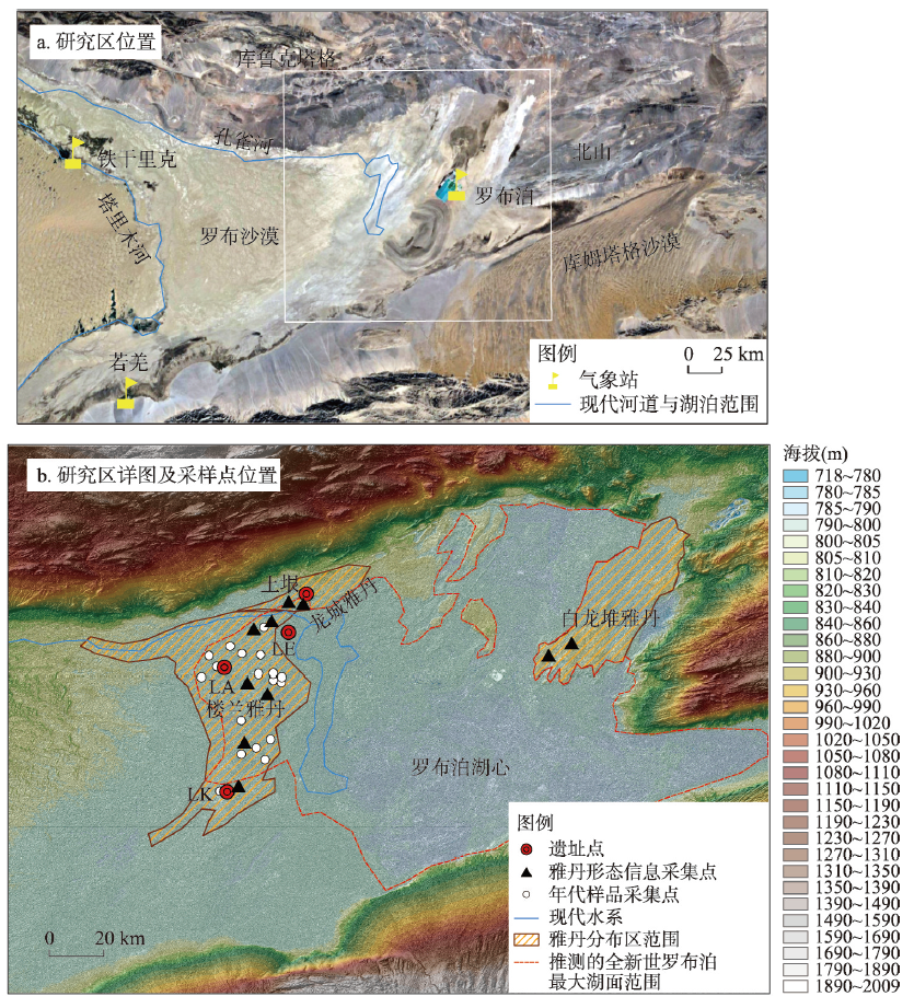
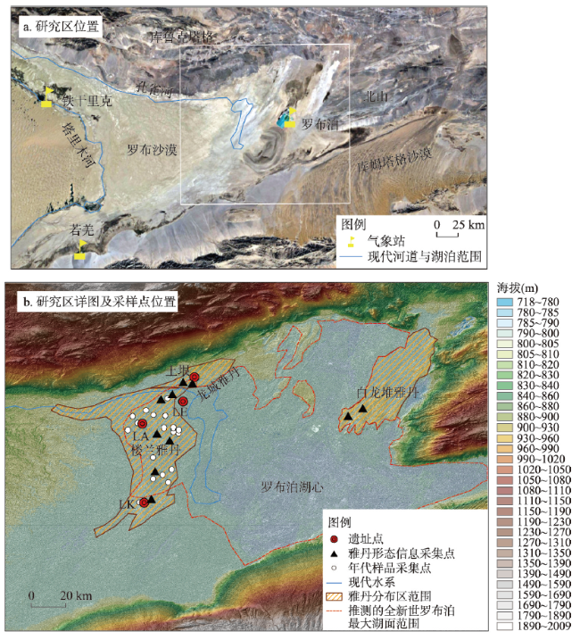
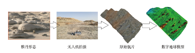
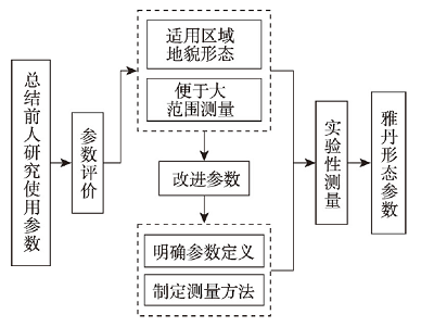
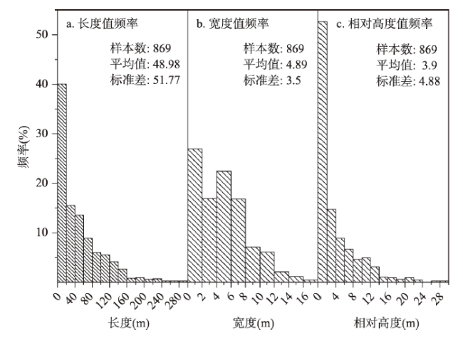
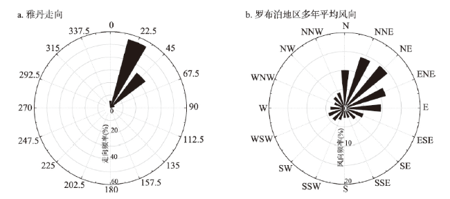
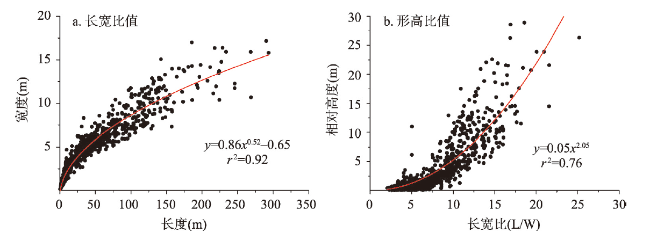
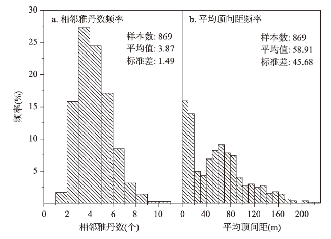
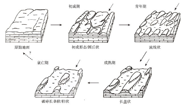
Yardang is a typical, aeolian erosion landform widely distributed on Earth and discovered on other planets (Venus and Mars) too. Because of its various forms and volatility, yardang's morphological characteristics have attracted attention for generations. Lop Nur is located in the eastern part of the Tarim Basin in Xinjiang, China. Although there are many yardangs with various types in the area of Lop Nur, there is a lack of study about this impressive landform there. On the basis of field investigation, the authors found that UAV drones can efficiently and effectively collect yardang morphology data. Based on collected yardang morphology data (including field survey and DEM from UAV), using the terrain digital extraction method, after measuring the morphological parameter data of yardang, this article attempts to clarify the morphological characteristics of yardangs in the Lop Nur area, and to discuss its formation processes. The main conclusions are as follows: (1) The lengths of yardangs in the Lop Nur area are often < 20 m, although a few of them are even > 160 m. The widths of yardangs in our study area are mainly < 8 m, with a height of mostly < 2 m. It shows that the sizes of yardangs in the study area are generally small, although some large ones occur too. The ratio of length vs. width (R) of yardangs ranges from 2:1 to 4:1, and even > 10:1. The orientations of the yardangs in our study area are mainly toward 22.5°-67.5°, consistent with the predominant wind directions. Our observations suggest that the morphology of yardangs in the study area initiated from a dome-shaped form and then changed to drop-shaped, and finally to linear forms. The number of yardangs occurring nearby is often 3-4, and the distance between them is often < 20 m but occasionally 40-80 m. (2) The most likely evolution processes of yardangs in the Lop Nur area can be summarized into four stages: embryonic, juvenile, mature and decay periods. However, due to the influence of various controlling factors such as stratum sediment characteristics, wind erosion, and flowing water, yardang's morphology in the Lop Nur area become quite complex. (3) The developments of yardangs in the Lop Nur area have multiple periods. Since the Quaternary, there have been four main development periods in late Pleistocene (ca. 90 ka B.P.), early Holocene (8-9 ka B.P.), late Holocene (after 1.6 ka B.P.) and Little Ice Age (around 0.5 ka B.P.). According to morphological characteristics and environmental evolution, we infer that yardangs in Longcheng and Bailongdui were formed in the late Pleistocene, the northern Loulan grand yardangs formed in the Early Holocene, yardangs in central and northern Loulan formed in the late Pleistocene and the small yardangs in Loulan area formed probably during the Little Ice Age. Based on the chronology and yardangs' height, the average wind erosion rate near the Loulan site after 0.5 ka B.P. was calculated to be 6.2 mm a-1. Accurately describing the morphological characteristics of yardangs in the Lop Nur area and understanding its evolution procession is of great significance for analyzing the morphological development of yardangs and the regional wind erosion process.
Key words: geomorphology; wind-eroded landform; Yardang; Lop Nur
SONG Haoze , YANG Xiaoping , MU Guijin , QIN Xiaoguang , LIN Yongchong . Geomorphology and origin of yardangs in Lop Nur Lake region[J]. Acta Geographica Sinica, 2021 , 76(9) : 2187 -2202 . DOI: 10.11821/dlxb202109011
表1 雅丹形态参数名称及指示意义Tab. 1 Names and definitions of yardang morphological parameters |
| 类别 | 缩写字母 | 单位 | 名称 | 指示意义 |
|---|---|---|---|---|
| 规模特征 | L | m | 长度(长) | 雅丹主延伸方向最大规模 |
| W | m | 宽度(宽) | 雅丹垂直主延伸方向最大规模 | |
| H | m | 相对高度(高) | 风蚀强度及雅丹所受风蚀作用时间的长短 | |
| 形态特征 | l | ° | 走向 | 风蚀动能集中作用方向 (近似指示盛行风方向) |
| R | - | 长宽比 | 雅丹平面形态 | |
| Rh | - | 形高比 | 雅丹平面形态与其所受风蚀作用时间长短的关系 | |
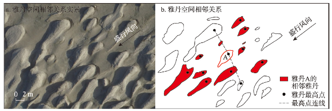
| 空间特征 | Nadj | 个 | 相邻雅丹数 | 雅丹空间距离及雅丹空间分布密度 |
| MD | m | 平均顶间距 |
表2 雅丹形态参数实测值和自动测量值对比及相对误差Tab. 2 Names and definitions of yardang morphological parameters |
| 类别 | YD-1 | YD-2 | YD-3 | YD-4 | YD-5 | YD-6 | YD-7 | YD-8 | YD-9 | Mean |
|---|---|---|---|---|---|---|---|---|---|---|
| Lm | 4.46 | 60.23 | 6.02 | 220.2 | 20.35 | 23.8 | 250.91 | 286.95 | 270.4 | - |
| Wm | 1.48 | 7.14 | 1.3 | 53.5 | 6.56 | 7.94 | 45.58 | 54.75 | 35.92 | - |
| Hm | 0.59 | 4.9 | 0.89 | 18.23 | 4.94 | 3.5 | 23.27 | 26.24 | 15.75 | - |
| La | 4.37 | 58.17 | 5.85 | 211.35 | 18.59 | 21.86 | 243.33 | 278.39 | 258.76 | - |
| Wa | 1.54 | 6.76 | 1.18 | 49.3 | 6.26 | 7.52 | 43.25 | 52.8 | 33.5 | - |
| Ha | 0.63 | 4.5 | 0.97 | 19.12 | 5.14 | 3.26 | 23.87 | 25.62 | 15.15 | - |
| RE-L | 2.02 | 3.42 | 2.82 | 4.02 | 8.65 | 8.15 | 3.02 | 2.98 | 4.30 | 4.38 |
| RE-W | 4.05 | 5.32 | 9.23 | 7.85 | 4.57 | 5.29 | 5.11 | 3.56 | 6.74 | 5.75 |
| RE-H | 6.78 | 8.16 | 8.99 | 4.88 | 4.05 | 6.86 | 2.58 | 2.36 | 3.81 | 5.39 |
注:Lm、Wm和Hm分别表示长宽高的实测值,La、Wa和Ha分别表示长宽高的自动测量值,RE-L、RE-W和RE-H分别表示长宽高的相对误差,所有测量值单位均为m。 |
| [1] |
|
| [2] |
|
| [3] |
|
| [4] |
|
| [5] |
[李露露, 董治宝, 李超, 等. 火星和地球雅丹形态学类比分析: 以埃律西昂平原和柴达木盆地为例. 中国沙漠, 2018, 38(4): 716-723.]
|
| [6] |
|
| [7] |
|
| [8] |
[陈宗器. 罗布淖尔与罗布荒原. 地理学报, 1936, 3(1): 19-49, 246.]
|
| [9] |
|
| [10] |
|
| [11] |
[范锡朋. 柴达木盆地西北部冷湖地区地貌概论. 地理学报, 1962, 28(4): 275-289.]
|
| [12] |
|
| [13] |
|
| [14] |
|
| [15] |
|
| [16] |
|
| [17] |
|
| [18] |
|
| [19] |
|
| [20] |
|
| [21] |
|
| [22] |
|
| [23] |
|
| [24] |
|
| [25] |
[夏训诚. 罗布泊科学考察与研究. 北京: 科学出版社, 1987.]
|
| [26] |
|
| [27] |
[夏训诚. 中国罗布泊. 北京: 科学出版社, 2007.]
|
| [28] |
[林永崇, 穆桂金, 秦小光, 等. 新疆楼兰地区雅丹地貌差异性侵蚀特征. 中国沙漠, 2017, 37(1): 33-39.]
|
| [29] |
[郑本兴, 张林源, 胡孝宏. 玉门关西雅丹地貌的分布和特征及形成时代问题. 中国沙漠, 2002, 22(1): 40-46.]
|
| [30] |
[林永崇, 穆桂金, 秦小光, 等. 地表风化作用对楼兰地区雅丹地貌发育的影响. 干旱区地理, 2018, 41(6): 1278-1284.]
|
| [31] |
[张小宏, 赵生良, 陈丰田. Agisoft photoscan在无人机航空摄影影像数据处理中的应用. 价值工程, 2013, 32(20): 230-231.]
|
| [32] |
|
| [33] |
[胡程青. 基于多源遥感影像的柴达木盆地雅丹几何学和控制因素[D]. 杭州: 浙江大学, 2017.]
|
| [34] |
|
| [35] |
|
| [36] |
[宋昊泽, 穆桂金, 林永崇, 等. 雅丹共基座现象对雅丹形态测量的影响. 干旱区地理, 2020, 43(1): 48-55.]
|
| [37] |
[杨更. 新疆雅丹地貌分布特征浅析. 四川地质学报, 2009, 29(Suppl.2): 286-290.]
|
| [38] |
|
| [39] |
|
| [40] |
|
| [41] |
[夏训诚. 新疆罗布泊科学考察综述. 干旱区研究, 1985, 2(1): 1-5.]
|
| [42] |
|
| [43] |
[牛清河, 屈建军, 柳本立, 等. 雅丹地貌形成年代研究方法简评与应用. 海洋地质与第四纪地质, 2013, 33(4): 201-208.]
|
| [44] |
|
| [45] |
|
| [46] |
[王富葆, 马春梅, 夏训诚, 等. 罗布泊地区自然环境演变及其对全球变化的响应. 第四纪研究, 2008, 28(1): 150-153.]
|
| [47] |
[王弭力. 罗布泊盐湖钾盐资源. 北京: 地质出版社, 2001.]
|
| [48] |
[贾红娟, 秦小光, 刘嘉麒. 楼兰佛塔剖面10. 84 ka B.P. 以来的环境变迁. 第四纪研究, 2010, 30(1): 175-184.]
|
| [49] |
[唐尚书. 汉唐间罗布泊地区的环境演变研究[D]. 兰州: 兰州大学, 2019.]
|
| [50] |
|
| [51] |
[林永崇, 穆桂金, 李文, 等. 小冰期新疆楼兰地区绿洲生态环境变迁事件. 干旱区资源与环境, 2020, 34(7): 125-132.]
|
| [52] |
[李康康, 秦小光, 张磊, 等. 罗布泊(楼兰)地区1260—1450 A.D. 期间的绿洲环境和人类活动. 第四纪研究, 2018, 38(3): 720-731.]
|
/
| 〈 |
|
〉 |