
Rank-size distribution of the modern China urban system based on the China Postal Atlas in 1936
Received date: 2020-05-28
Request revised date: 2021-07-08
Online published: 2021-10-25
Supported by
Yongyou Foundation(2018Y09)
General Project of Shanghai Philosophy and Social Science Planning(2018BLS008)
Copyright
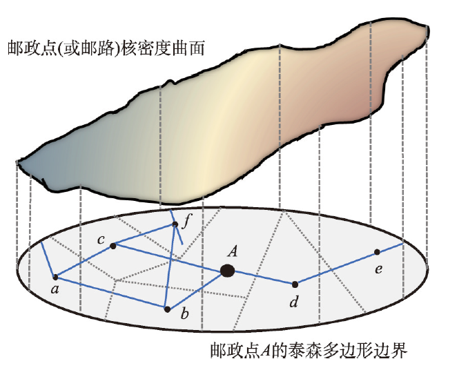
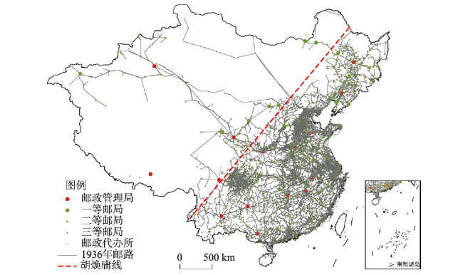
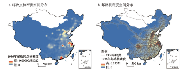
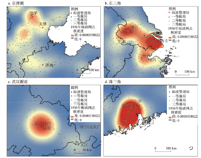
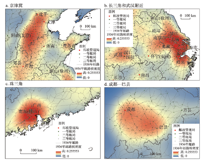
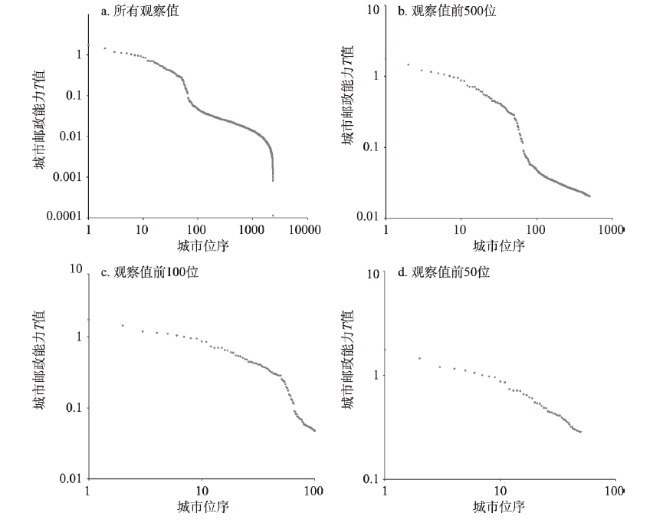
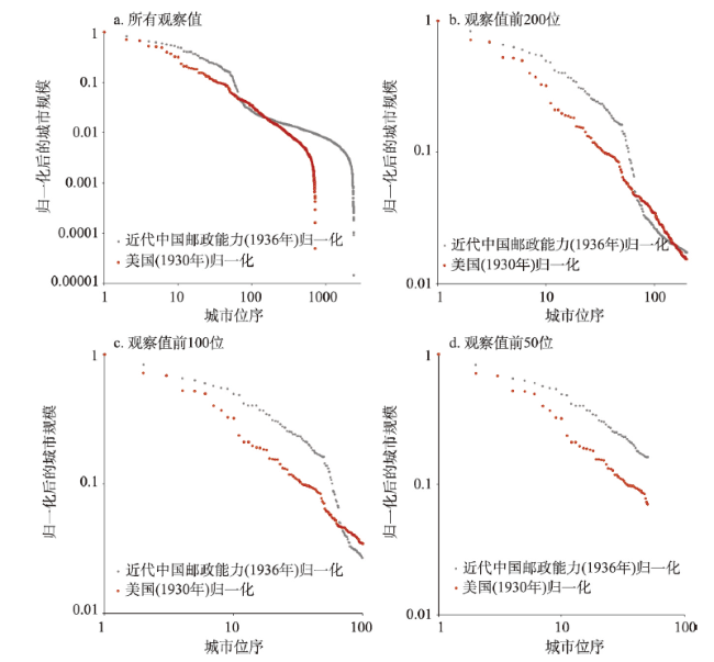
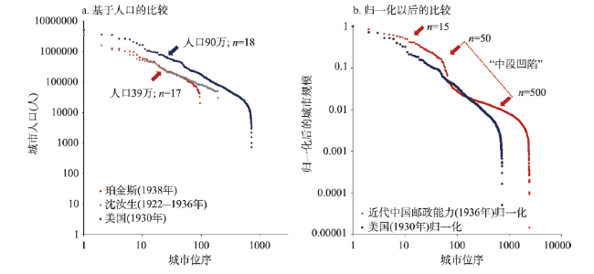
The lack of governmental and systematic urban population data limit the study progress in urban systems in China's historical period, which has great negative effect on quantitative analysis of urban system rank-size distribution. This paper digitized the "China Postal Atlas" in 1936, based on its 13240 postal points and more than 40000 km postal routes, and examined the spatial distribution of the kernel density of postal points and routes, using the Thiessen Polygon, Zonal Statistics and other GIS tools to give value to the postal capacity T of modern Chinese cities. T-value is used as a proxy for city size in modern China to analyze the rank-size rule. The conclusions are as follows. (1) The distribution of rank-size of cities in modern China based on the T-value was in accordance with Zipf's law. (2) In 1936, there were five postal aggregation areas in China: Beijing-Tianjin-Hebei region, the Yangtze River Delta, the Pearl River Delta, Wuhan and Chengdu-Baxian region, which is highly consistent with the current distribution of China's urban agglomerations. (3) In 1936, the spatial distribution of postal points and routes was very different on both sides of the "Hu Huangyong Line". The northwestern half to the line had a slightly smaller proportion of points than that of population, but a much higher proportion of high-grade points and routes than that of population. (4) In this paper, the sample size of urban system in modern China increased from about 200 (urban population) to 2360 (T-value). For the first time, the "three-stage" distribution caused by the unique "depression in the middle section" of the city size curve was found, which was quite different from that of the United States and China today. (5) The postal capacity T-value can be considered as a proxy for city size in urban geography studies in modern China.
Key words: China Postal Atlas; urban system; rank-size rule; urban population; Hu Huanyong Line; China
WANG Zhe , ZHENG Fachuan . Rank-size distribution of the modern China urban system based on the China Postal Atlas in 1936[J]. Acta Geographica Sinica, 2021 , 76(8) : 1910 -1923 . DOI: 10.11821/dlxb202108007
表1 1936年中国邮政网点及官方设定标准Tab. 1 Standards for the postal points in 1936 |
| 等级 | 数量(个) | 官方设定标准 |
|---|---|---|
| 邮政管理局 | 29 | 省会或首都 |
| 一等邮局 | 47 | 营收5000元/月 |
| 支局 | 195 | 位于大城市内部;视同二等邮局 |
| 二等邮局 | 984 | 营收600元/月 |
| 三等邮局 | 1562 | 营收200元/月 |
| 邮政代办所 | 11536 | 营收27元/月 |
| 村镇信站 | 93 | 乡村邮递员所经村落 |
注:官方设定标准见参考文献[35]。 |
表2 1936年“胡焕庸线”西北半壁邮政网点和邮路比例Tab. 2 Percentage of postal points and routes on two sides of "Hu Huanyong Line" in 1936 |
| 邮政等级 | 数量(个) | “胡焕庸线”西北半壁数量(个) | “胡焕庸线”西北半壁占比(%) |
|---|---|---|---|
| 邮政管理局 | 29 | 5 | 17.2 |
| 一等邮局 | 47 | 10 | 21.3 |
| 支局 | 195 | 4 | 2.1 |
| 二等邮局 | 984 | 40 | 4.1 |
| 三等邮局 | 1562 | 66 | 4.2 |
| 邮政代办所 | 11536 | 272 | 2.4 |
| 村镇信站 | 93 | 18 | 19.4 |
| 邮路数 | 17604 | 613 | 3.5 |
| 邮路总里程(km) | 407799 | 55776 | 13.7 |
| 合计 | 13240 | 415 | 3.1 |
注:所谓邮路数,简单起见,指的是任一个邮政网点之间的邮路,均视为1个独立的邮路。 |
表3 基于邮政能力T值的近代中国城市位序规模分析结果及与1949年后的对比Tab. 3 Statistical results of rank-size distribution of modern China cities in 1936 based on postal capability value T comparisons with 1953, 1963 and 1973 |
| 观察范围 | q(斜率) | R(相关系数) |
|---|---|---|
| 所有观察值 | -0.85 | -0.941 |
| 观察值前500位城市 | -0.94 | -0.953 |
| 观察值前100位城市 | -1.02 | -0.898 |
| 观察值前50位城市 | -0.53 | -0.974 |
| 1953年(中国前100位城市) | -0.91 | -0.990 |
| 1963年(中国前100位城市) | -0.84 | -0.992 |
| 1973年(中国前100位城市) | -0.81 | -0.991 |
注:1949年后数据来自参考文献[48]。 |
表4 基于邮政能力T值的近代中国城市位序规模分析结果及美国的对比Tab. 4 Statistical results of city rank-size distribution based on postal capability value T in comparison of China in 1936 with the USA in 1930 |
| 观察范围 | q(斜率) | R(相关系数) |
|---|---|---|
| 所有观察值(近代中国邮政) | -0.850 | -0.9411 |
| 所有观察值(美国1930年) | -1.179 | -0.9512 |
| 观察值前50位城市(近代中国邮政) | -0.531 | -0.9736 |
| 观察值前50位城市(美国1930年) | -0.743 | -0.9894 |
| [1] |
[ 费尔南·布罗代尔. 十五至十八世纪的物质文明、经济和资本主义: 第一卷日常生活的结构: 可能和不可能. 顾良, 施康强, 译. 北京: 商务印书馆, 2017.]
|
| [2] |
[ 安东尼·吉登斯. 资本主义与现代社会理论: 对马克思、涂尔干和韦伯著作的分析. 郭忠华, 潘华凌, 译. 上海: 上海译文出版社, 2018.]
|
| [3] |
[ 马克斯·韦伯. 中国的宗教: 儒教与道教. 康乐, 简惠美, 译. 桂林: 广西师范大学出版社, 2010.]
|
| [4] |
|
| [5] |
|
| [6] |
|
| [7] |
|
| [8] |
|
| [9] |
|
| [10] |
|
| [11] |
[ 谈明洪, 李秀彬. 20世纪美国城市体系的演变及其对中国的启示. 地理学报, 2010, 65(12):1488-1495.]
|
| [12] |
|
| [13] |
|
| [14] |
|
| [15] |
|
| [16] |
|
| [17] |
|
| [18] |
[ 薛俊菲. 基于航空网络的中国城市体系等级结构与分布格局. 地理研究, 2008, 27(1):23-32.]
|
| [19] |
[ 钟业喜, 陆玉麒. 基于铁路网络的中国城市等级体系与分布格局. 地理研究, 2011, 30(5):785-794.]
|
| [20] |
[ 甄峰, 王波, 陈映雪. 基于网络社会空间的中国城市网络特征: 以新浪微博为例. 地理学报, 2012, 67(8):1031-1043.]
|
| [21] |
[ 焦敬娟, 王姣娥, 金凤君, 等. 高速铁路对城市网络结构的影响研究: 基于铁路客运班列分析. 地理学报, 2016, 71(2):265-280.]
|
| [22] |
[ 陈伟, 刘卫东, 柯文前, 等. 基于公路客流的中国城市网络结构与空间组织模式. 地理学报, 2017, 72(2):224-241.]
|
| [23] |
[ 王姣娥, 景悦. 中国城市网络等级结构特征及组织模式: 基于铁路和航空流的比较. 地理学报, 2017, 72(8):1508-1519.]
|
| [24] |
[ 胡国建, 陈传明, 金星星, 等. 中国城市体系网络化研究. 地理学报, 2019, 74(4):681-693.]
|
| [25] |
[ 王姣娥, 杜德林, 金凤君. 多元交通流视角下的空间级联系统比较与地理空间约束. 地理学报, 2019, 74(12):2482-2494.]
|
| [26] |
[ 顾朝林, 于涛方, 李王鸣, 等. 中国城市化: 格局·过程·机理. 北京: 科学出版社, 2008.]
|
| [27] |
[ 肖爱玲. 西汉城市体系的空间演化. 北京: 商务印书馆, 2012.]
|
| [28] |
[ 肖爱玲. 西汉初年汉郡区城市等级及空间分布特征探析: 张家山汉简研究. 中国历史地理论丛, 2007, 22(4):60-70.]
|
| [29] |
|
| [30] |
[ 曹树基. 清代北方城市人口研究: 兼与施坚雅商榷. 中国人口科学, 2001(4):15-28.]
|
| [31] |
[ 张其昀. 近二十年来中国地理学之进步(上). 地理学报, 1935, 2(3):93-132.]
|
| [32] |
[ 费正清, 费维恺. 剑桥中华民国史, 1912—1949(下). 刘敬坤, 叶宗敭, 曾景忠, 等, 译. 北京: 中国社会科学出版社, 1994: 175.]
|
| [33] |
|
| [34] |
CHGIS, Version: 2.0. Cambridge, Version: 2.0. Cambridge, MA: Harvard Yenching Institute, 2003.
|
| [35] |
[ 张樑任. 中国邮政(上). 上海: 商务印书馆, 1935: 78.]
|
| [36] |
US Census Bureau. Metropolitan Area Population: 1900-2000. [2020-08-27]. http://www.demographia.com/db-met1900.pdf.
|
| [37] |
[ 侯杨方. 中国人口史第六卷(1910—1953年). 上海: 复旦大学出版社, 2001: 477.]
|
| [38] |
[ 沈汝生. 中国都市之分布. 地理学报, 1937, 4(1):915-935.]
|
| [39] |
The Special Committee on Survey and Occupation China Continuation Committee. The Christian Occupation of China, Part 2. Cai Yongchun, Wen Yong, Duan Qi, et al. trans. Beijing: China Social Sciences Press, 2007: 1507-1512.
[中华续行委办会调查特委会. 1901—1920年中国基督教调查资料(下卷). 蔡詠春, 文庸, 段琦, 等, 译. 北京: 中国社会科学出版社, 2007: 1507-1512.]
|
| [40] |
[ 德怀特·珀金斯. 中国农业发展(1368—1968年). 宋海文, 等, 译. 上海: 上海译文出版社, 1984: 386-395.]
|
| [41] |
|
| [42] |
[ 胡焕庸. 中国人口之分布: 附统计表与密度图. 地理学报, 1935, 2(2):33-74.]
|
| [43] |
[ 陈明星, 李扬, 龚颖华, 等. 胡焕庸线两侧的人口分布与城镇化格局趋势: 尝试回答李克强总理之问. 地理学报, 2016, 71(2):179-193.]
|
| [44] |
[ 黄镇国, 李平日, 张仲英, 等. 珠江三角洲形成发育演变. 广州: 科学普及出版社广州分社, 1982.]
|
/
| 〈 |
|
〉 |
