
The geographical pattern and differentiational mechanism of rural poverty in China
Received date: 2020-01-05
Request revised date: 2020-10-19
Online published: 2021-06-25
Supported by
National Natural Science Foundation of China(41871183)
National Natural Science Foundation of China(41601172)
Strategic Priority Research Program of the Chinese Academy of Sciences(XDA23070301)
China Postdoctoral Science Foundation(2016M591105)
Copyright
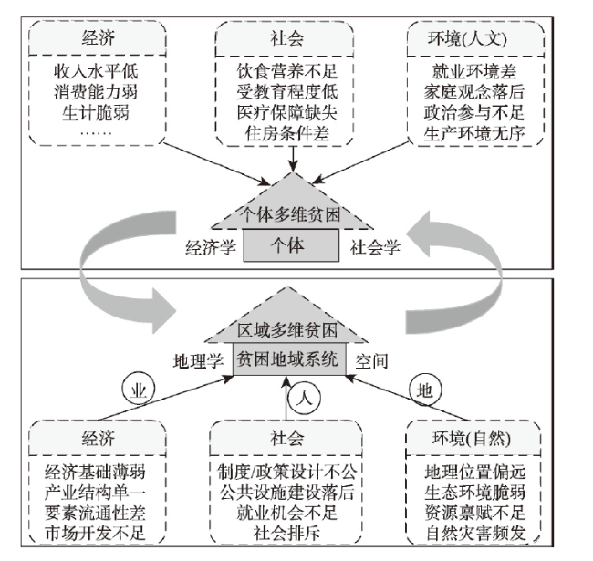
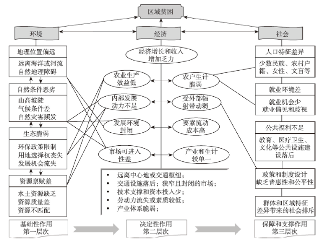
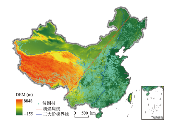
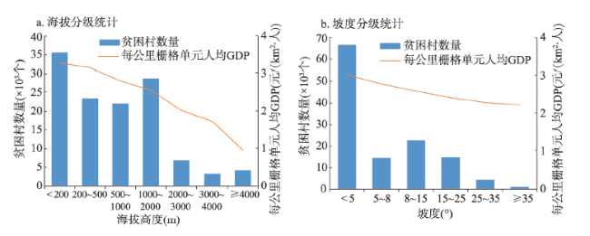
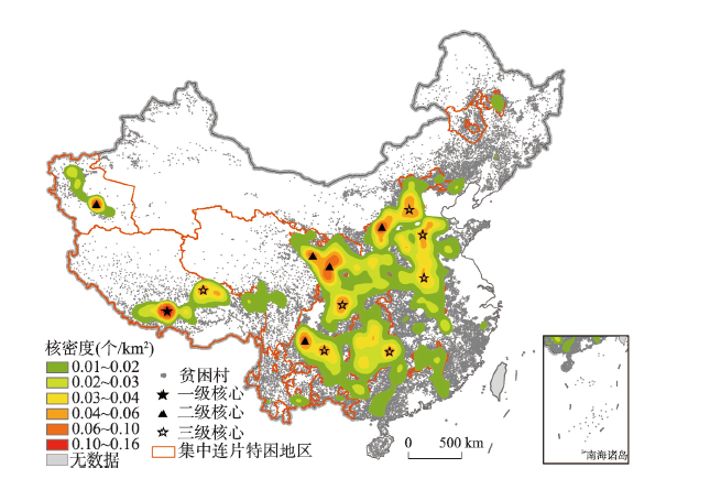
Poverty eradication is a worldwide concern. Regional impoverishment has been considered to be closely related to the geographical environment. Therefore, the relationship between poverty and geographical environment has become the core content of poverty geography. Based on the theoretical basis of regional multidimensional poverty and impoverished areal system, this study constructed a "poverty-environment-economy-society" analytical framework to examine the nexus between poverty and geo-environment. On this basis, taking 124000 poverty-stricken villages as the research object, this study used the methods of spatial autocorrelation, kernel density analysis and geographical detector to depict the spatial geographical pattern of China's poverty-stricken villages in the new era, quantitatively detect the leading factors of the regional differentiation of poverty-stricken villages, and reveal the interaction mechanism between the village impoverishment and the geographical environment. The main conclusions can be drawn in the following three aspects. First of all, poverty and the geo-environment interact with each other, and the paths and manifestations of the interaction between the two are complex and diverse. In general, factors leading to village poverty can be detected from the two categories of nature and humanities and the three dimensions of environment, economy, and society. Environmental factors play a fundamental role in the evolution of poverty, economic factors are the most direct and important contributor to impoverishment, and social factors have a magnifying effect on poverty. Secondly, the distribution of poor villages in China has obvious spatial agglomeration characteristics. The spatial distribution pattern of poverty-stricken villages across the country is consistent with the basic geographic pattern depicted by the Hu Huanyong Line and the three-level topography, with obvious vertical and slope differentiation characteristics. The poor villages in China are spatially distributed with one first-level core area, five second-level core areas and seven third-level core areas. Last but not least, the spatial distribution pattern of poor villages in China is the result of the interaction of multiple factors. Topography, natural resources endowment, labors, transportation and public services were identified as the main contributors to spatial differentiation of poor villages in China. Interaction detection results indicated that the driving force between two-factor interaction is stronger than that of a single factor, and the interaction types are non-linear enhancement except for topographic factors and location. Facing the 2030 UN Sustainable Development Goals, China needs to establish the long-term mechanism to effectively link up poverty reduction, rural revitalization, ecological civilization construction, territorial space optimization and urban-rural integrated development, so as to stimulate the endogenous development momentum of poverty-stricken areas and promote regional sustainable development.

ZHOU Yang , LI Xunhuan , TONG Chunyang , HUANG Han . The geographical pattern and differentiational mechanism of rural poverty in China[J]. Acta Geographica Sinica, 2021 , 76(4) : 903 -920 . DOI: 10.11821/dlxb202104009
表1 贫困村地理空间识别指标体系Tab. 1 Index system for geospatial identification of poverty-stricken villages |
| 系统类型 | 影响要素 | 指标 | 指标释义与计算方法 |
|---|---|---|---|
| 环境系统 | 地形条件 | X1: 海拔(m) | 提取贫困村的高程值 |
| X2: 坡度(°) | 提取贫困村的坡度值 | ||
| X3: 地形起伏度(m) | 提取贫困村的地形起伏度 | ||
| 气候变化 | X4: 气温变化量(℃) | 2015年平均气温-2000年平均气温 | |
| X5: 降水变化量(mm) | 2015年降水量-2000年降水量 | ||
| 自然灾害 | X6: 地质灾害发生次数(次) | 村域内发生地质灾害次数 | |
| X7: 地质灾害造成财产威胁(元) | 村域内发生地质灾害造成财产威胁的总和 | ||
| 生态脆弱性 | X8: 归一化植被指数 | 提取贫困村的NDVI值 | |
| X9: 土壤中度侵蚀及以上的面积(km2) | 土壤中度/强度/极强度/剧烈侵蚀的面积 | ||
| X10: 植被净初级生产力(gC/km2) | 提取贫困村的NPP值 | ||
| 资源禀赋 | X11: 人均耕地面积(km2/人) | 贫困村所在网格内的耕地面积/人口 | |
| X12: 年降水量(mm) | 提取贫困村的年降水量 | ||
| 社会系统 | 人口条件 | X13: 人口增长速度(%) | (2015年人口-2000年人口)/2000年人口总量 |
| X14: 人口外流率(%) | (农村户籍人口-农村常住人口)/农村户籍人口 | ||
| X15: 劳动力数量(人/户) | 贫困村户均家庭劳动力数量 | ||
| 公共服务 | X16: 教育资源可达性(km) | 到学校(幼儿园、大中小学)的最短距离 | |
| X17: 医疗资源可达性(km) | 到卫生室、卫生院、医院、诊所的最短距离 | ||
| 经济系统 | 区位条件 | X18: 到县域交通干线的最短距离(km) | 贫困村到县道/省道的最短距离 |
| X19: 交通通达度(min) | 贫困村到县政府驻点的通行时间 | ||
| 农业生产条件 | X20: 农田生产潜力(kg/hm2) | 贫困村内土地的粮食生产潜力 | |
| 经济发展水平 | Y: 每公里栅格单元人均GDP(元/(km2·人)) | 2015年每公里栅格单元的GDP/人口 |
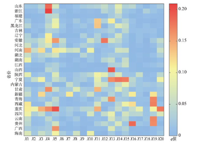
表2 中国贫困村地域分异因子探测结果Tab. 2 Factor detection results of regional differentiation of poverty-stricken villages in China |
| 影响因子 | q值 | 影响因子 | q值 | 影响因子 | q值 | 影响因子 | q值 |
|---|---|---|---|---|---|---|---|
| X1 | 0.055** | X6 | 0.000 | X11 | 0.005** | X16 | 0.021** |
| X2 | 0.010** | X7 | 0.000 | X12 | 0.022** | X17 | 0.011** |
| X3 | 0.012** | X8 | 0.004** | X13 | 0.016** | X18 | 0.013** |
| X4 | 0.016** | X9 | 0.007** | X14 | 0.012** | X19 | 0.022** |
| X5 | 0.014** | X10 | 0.011** | X15 | 0.028** | X20 | 0.009** |
注:**表示在5%水平上显著。 |
表3 中国贫困村地域分异的交互探测结果Tab. 3 Interactive detection results of regional differentiation of poverty-stricken villages in China |
| q值 | X1 | X2 | X3 | X4 | X5 | X9 | X10 | X12 | X13 | X14 | X15 | X16 | X17 | X18 | X19 | X20 |
|---|---|---|---|---|---|---|---|---|---|---|---|---|---|---|---|---|
| X1 | 0.06 | |||||||||||||||
| X2 | 0.06 | 0.01 | ||||||||||||||
| X3 | 0.06 | 0.01 | 0.01 | |||||||||||||
| X4 | 0.10 | 0.02 | 0.03 | 0.02 | ||||||||||||
| X5 | 0.07 | 0.03 | 0.03 | 0.06 | 0.01 | |||||||||||
| X9 | 0.06 | 0.02 | 0.02 | 0.03 | 0.02 | 0.01 | ||||||||||
| X10 | 0.07 | 0.03 | 0.04 | 0.05 | 0.04 | 0.02 | 0.01 | |||||||||
| X12 | 0.08 | 0.04 | 0.04 | 0.07 | 0.05 | 0.03 | 0.04 | 0.02 | ||||||||
| X13 | 0.08 | 0.14 | 0.14 | 0.10 | 0.09 | 0.13 | 0.09 | 0.15 | 0.02 | |||||||
| X14 | 0.09 | 0.03 | 0.04 | 0.05 | 0.04 | 0.03 | 0.05 | 0.05 | 0.09 | 0.01 | ||||||
| X15 | 0.07 | 0.04 | 0.04 | 0.07 | 0.05 | 0.04 | 0.05 | 0.06 | 0.15 | 0.06 | 0.03 | |||||
| X16 | 0.07 | 0.03 | 0.04 | 0.04 | 0.04 | 0.02 | 0.03 | 0.03 | 0.06 | 0.04 | 0.03 | 0.02 | ||||
| X17 | 0.06 | 0.02 | 0.02 | 0.04 | 0.03 | 0.02 | 0.03 | 0.04 | 0.06 | 0.04 | 0.04 | 0.02 | 0.01 | |||
| X18 | 0.07 | 0.02 | 0.02 | 0.04 | 0.03 | 0.02 | 0.03 | 0.03 | 0.06 | 0.04 | 0.04 | 0.04 | 0.02 | 0.01 | ||
| X19 | 0.06 | 0.03 | 0.03 | 0.04 | 0.03 | 0.03 | 0.04 | 0.04 | 0.04 | 0.05 | 0.04 | 0.02 | 0.02 | 0.02 | 0.02 | |
| X20 | 0.06 | 0.01 | 0.02 | 0.03 | 0.04 | 0.02 | 0.04 | 0.04 | 0.13 | 0.04 | 0.04 | 0.03 | 0.02 | 0.02 | 0.03 | 0.01 |
注:灰色填充表示单因子作用,黄色填充表示交互作用类型为双因子增强,淡蓝色表示交互作用类型为非线性增强。受篇幅限制,表中删除了驱动力较弱的影响因子。 |
感谢中国科学院地理科学与资源研究所硕士研究生伍程斌在技术上提供的帮助。
| [1] |
|
| [2] |
[ 方晓丹. 2019年全国农村贫困人口减少1109万人. http://www.stats.gov.cn/tjsj/sjjd/202001/t20200123_1724700.html, 2020-04-05.]
|
| [3] |
[ 刘彦随, 周扬, 刘继来. 中国农村贫困化地域分异特征及其精准扶贫策略. 中国科学院院刊, 2016,31(3):269-278.]
|
| [4] |
[ 李寻欢, 周扬, 陈玉福. 区域多维贫困测量的理论与方法. 地理学报, 2020,75(4):753-768.]
|
| [5] |
|
| [6] |
|
| [7] |
|
| [8] |
[ 王小林. 贫困测量: 理论与方法. 2版. 北京: 社会科学文献出版社, 2017.]
|
| [9] |
|
| [10] |
UNDP. Human Development Report 1990: Concept and Measurement of Human Development. New York and Oxford: Oxford University Press, 1990.
|
| [11] |
|
| [12] |
DFID. Sustainable Livelihoods Guidance Sheets. UK: Department for International Development, 2000.
|
| [13] |
[ 陈全功, 程蹊. 空间贫困及其政策含义. 贵州社会科学, 2010(8):87-92.]
|
| [14] |
[ 文琦, 施琳娜, 马彩虹, 等. 黄土高原村域多维贫困空间异质性研究: 以宁夏彭阳县为例. 地理学报, 2018,73(10):1850-1864.]
|
| [15] |
[ 郭来喜, 姜德华. 中国贫困地区环境类型研究. 地理研究, 1995,14(2):1-7.]
|
| [16] |
[ 周扬, 李寻欢. 平原农区贫困地理格局及其分异机制: 以安徽省利辛县为例. 地理科学, 2019,39(10):1592-1601.]
|
| [17] |
[ 刘艳华, 徐勇. 中国农村多维贫困地理识别及类型划分. 地理学报, 2015,70(6):993-1007.]
|
| [18] |
[ 潘竟虎, 赵宏宇, 董磊磊. 基于DMSP-OLS数据和可持续生计的中国农村多维贫困空间识别. 生态学报, 2018,38(17):6180-6193.]
|
| [19] |
[ 潘竟虎, 冯娅娅. 中国农村深度贫困的空间扫描与贫困分异机制的地理探测. 地理学报, 2020,75(4):769-788.]
|
| [20] |
[ 周扬, 郭远智, 刘彦随. 中国县域贫困综合测度及2020年后减贫瞄准. 地理学报, 2018,73(8):1478-1493.]
|
| [21] |
|
| [22] |
|
| [23] |
|
| [24] |
|
| [25] |
|
| [26] |
|
| [27] |
[ 刘彦随, 李进涛. 中国县域农村贫困化分异机制的地理探测与优化决策. 地理学报, 2017,72(1):161-173.]
|
| [28] |
|
| [29] |
|
| [30] |
[ 傅伯杰. 地理学综合研究的途径与方法: 格局与过程耦合. 地理学报, 2014,69(8):1052-1059.]
|
| [31] |
[ 陈烨烽, 王艳慧, 赵文吉, 等. 中国贫困村致贫因素分析及贫困类型划分. 地理学报, 2017,72(10):1827-1844.]
|
| [32] |
[ 陈烨烽, 王艳慧, 王小林. 中国贫困村测度与空间分布特征分析. 地理研究, 2016,35(12):2298-2308.]
|
| [33] |
|
| [34] |
|
| [35] |
[ 丁建军, 冷志明. 区域贫困的地理学分析. 地理学报, 2018,73(2):232-247.]
|
| [36] |
[ 吴传钧. 论地理学的研究核心: 人地关系地域系统. 经济地理, 1991,11(3):1-6.]
|
| [37] |
|
| [38] |
UNDP, UNEP. The Poverty-Environment Accounting Framework (PEAF): The Application of the System of Environmental-Economic Accounting (SEEA 2012) for Integrated Planning, Budgeting and Monitoring for Poverty Related Sustainable Development Goals (SDG). 2016.
|
| [39] |
|
| [40] |
Research Centre for Sustainable Development. Climate change-induced poverty in rural areas: The global and China's perspectives. 2018.
[ 中国社会科学院可持续发展研究中心课题组. 气候贫困: 气候变化对农村贫困的影响、认知与启示. 2018.]
|
| [41] |
|
| [42] |
|
| [43] |
World Commission on Environment and Development. Report of the World Commission on Environment and Development: Our Common Future. 1987. https://sustainabledevelopment.un.org/content/documents/5987our-common-future.pdf
|
| [44] |
Poverty, Global Chronic. The Chronic Poverty Report 2004-05. Manchester: The Chronic Poverty Research Centre, 2004.
|
| [45] |
|
| [46] |
[ 周扬, 童春阳. 中国经济增长与公共投资的减贫效应测度研究. 经济经纬, 2019,36(6):32-39.]
|
| [47] |
|
| [48] |
[ 刘小鹏, 李永红, 王亚娟, 等. 县域空间贫困的地理识别研究: 以宁夏泾源县为例. 地理学报, 2017,72(3):545-557.]
|
| [49] |
|
| [50] |
|
| [51] |
|
| [52] |
|
| [53] |
|
| [54] |
[ 王劲峰, 徐成东. 地理探测器: 原理与展望. 地理学报, 2017,72(1):116-134.]
|
/
| 〈 |
|
〉 |