
China's city network based on Tencent's migration big data
Received date: 2019-07-26
Request revised date: 2020-10-18
Online published: 2021-06-25
Supported by
National Natural Science Foundation of China(41261042)
Copyright
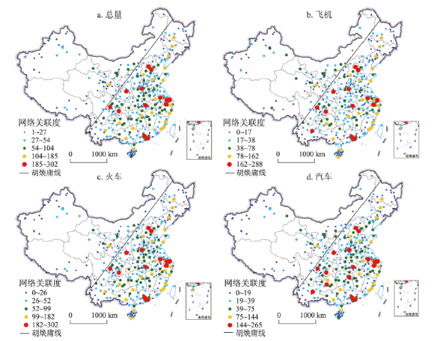
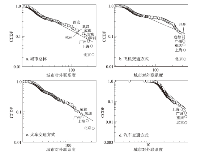
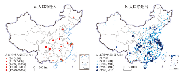
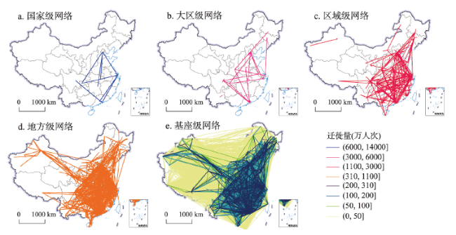
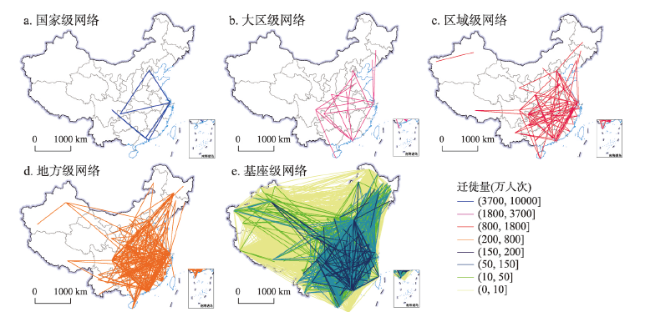
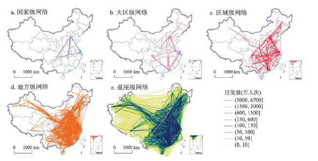
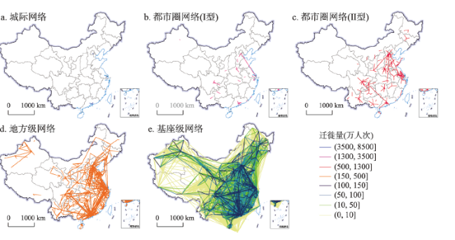
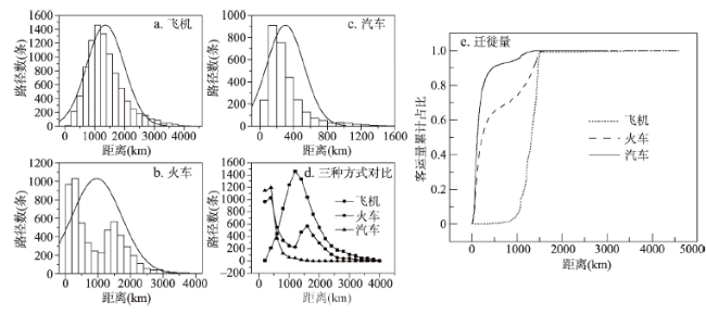
With the rapid development of economic globalization and regional integration, the connection between cities is increasingly close. The mobility and interdependence of elements have promoted the formation of city network and become a new regional organization model and spatial structure. Based on Tencent's migration data, this paper constructs a 372×372 relational data matrix, and systematically depicts the city network pattern in China from different modes of transportation. The results show that cities with high network correlation degree are mainly concentrated in the area east of the Hu Huanyong Line, especially in the Yangtze River Delta, Pearl River Delta, Beijing-Tianjin-Hebei region, Chengdu-Chongqing region and other urban agglomeration areas, which have the highest concentration and become the main control power of China's city network pattern; and the cities in the northwest half are at a disadvantage status. According to the amount of migration, the Chinese city network is divided into national, large regional, regional, local and pedestal networks. The city network structure changes with the mode of transportation. When the network level moves down, the number of node cities tends to increase and the network density increases, but the network range tends to shrink. There is a close correlation between the network level and the migration path. National-level network related to air transportation, regional network related to railway transportation, and local network are relevant to automobile transportation. The economic space-time distance of different transportation modes determines the network structure, which is the basic factor that causes the network to differentiate with different paths.

Key words: city network; Tencent's migration big data; heteromorphism; China
WANG Lucang , LIU Haiyang , LIU Qing . China's city network based on Tencent's migration big data[J]. Acta Geographica Sinica, 2021 , 76(4) : 853 -869 . DOI: 10.11821/dlxb202104006
表1 胡焕庸线两侧(东南、西北)城市的数量占比(%)Tab. 1 Proportion of cities on both sides of the Hu Huanyong Line |
| 网络级别 | 1级 | 2级 | 3级 | 4级 | 5级 | |||||||||
|---|---|---|---|---|---|---|---|---|---|---|---|---|---|---|
| 胡焕庸线两侧 | 东南 | 西北 | 东南 | 西北 | 东南 | 西北 | 东南 | 西北 | 东南 | 西北 | ||||
| 飞机 | 100 | 0 | 95.83 | 4.17 | 78.26 | 21.74 | 86.67 | 13.33 | 73.84 | 26.16 | ||||
| 火车 | 100 | 0 | 96.30 | 3.70 | 93.44 | 6.56 | 84.80 | 15.20 | 66.90 | 33.10 | ||||
| 汽车 | 100 | 0 | 95.45 | 4.55 | 89.06 | 10.94 | 86.07 | 13.93 | 75.40 | 24.60 | ||||
| 总体 | 100 | 0 | 96.00 | 4.00 | 90.14 | 9.86 | 86.76 | 13.24 | 61.90 | 38.10 | ||||
表2 不同运输方式下的网络阶层平均聚类系数和平均路径长度Tab. 2 Average clustering coefficient and average path length for different modes of transportation |
| 层级 | 平均聚类 系数 | 平均路径 长度 | 迁徙量 占比(%) | |
|---|---|---|---|---|
| 总网 | 1 | 0.086 | 2.423 | 11.09 |
| 2 | 0.000 | 3.247 | 11.34 | |
| 3 | 0.051 | 4.293 | 29.66 | |
| 4 | 0.146 | 5.416 | 30.08 | |
| 5 | 0.235 | 2.180 | 17.83 | |
| 飞机 | 1 | 0.361 | 1.733 | 20.51 |
| 2 | 0.000 | 3.025 | 15.14 | |
| 3 | 0.003 | 3.388 | 22.78 | |
| 4 | 0.025 | 3.393 | 21.77 | |
| 5 | 0.163 | 2.623 | 19.80 | |
| 火车 | 1 | 0.110 | 1.708 | 7.98 |
| 2 | 0.061 | 3.050 | 12.92 | |
| 3 | 0.061 | 4.519 | 28.87 | |
| 4 | 0.150 | 5.145 | 32.51 | |
| 5 | 0.231 | 2.208 | 17.71 | |
| 汽车 | 1 | 0.000 | 1.167 | 6.92 |
| 2 | 0.036 | 1.404 | 13.99 | |
| 3 | 0.066 | 3.683 | 27.67 | |
| 4 | 0.172 | 7.530 | 33.31 | |
| 5 | 0.265 | 2.446 | 18.10 |
| [1] |
|
| [2] |
[ 王珏, 陈雯, 袁丰. 基于社会网络分析的长三角地区人口迁移及演化. 地理研究, 2014,33(2):385-400.]
|
| [3] |
[ 赵梓渝, 魏冶, 王士君, 等. 有向加权城市网络的转变中心性与控制力测度: 以中国春运人口流动网络为例. 地理研究, 2017,36(4):647-660.]
|
| [4] |
[ 曼纽尔·卡斯特. 网络社会的崛起. 夏铸九 等, 译. 北京: 社会科学文献出版社, 2006.]
|
| [5] |
|
| [6] |
|
| [7] |
|
| [8] |
|
| [9] |
|
| [10] |
|
| [11] |
|
| [12] |
[ 马丽亚, 修春亮, 冯兴华. 基于母子企业联系的东北三省城市网络特征. 地理科学, 2019,39(7):1129-1138.]
|
| [13] |
[ 金钟范. 基于企业母子联系的中国跨国城市网络结构: 以中韩城市之间联系为例. 地理研究, 2010,29(9):1670-1682.]
|
| [14] |
[ 王成, 王茂军. 山东省城市关联网络演化特征: 基于“中心地”和“流空间”理论的对比. 地理研究, 2017,36(11):2197-2212.]
|
| [15] |
[ 叶磊, 段学军. 基于物流企业的长三角地区城市网络结构. 地理科学进展, 2016,35(5):622-631.]
|
| [16] |
[ 金凤君. 我国航空客流网络发展及其地域系统研究. 地理研究, 2001,20(1):31-39.]
|
| [17] |
[ 武文杰, 董正斌, 张文忠, 等. 中国城市空间关联网络结构的时空演变. 地理学报, 2011,66(4):435-445.]
|
| [18] |
[ 王姣娥, 景悦. 中国城市网络等级结构特征及组织模式: 基于铁路和航空流的比较. 地理学报, 2017,72(8):1508-1519.]
|
| [19] |
[ 冯兴华, 修春亮, 刘志敏, 等. 东北地区城市网络层级演变特征分析: 基于铁路客运流视角. 地理科学, 2018,38(9):1430-1438.]
|
| [20] |
[ 孟德友, 冯兴华, 文玉钊. 铁路客运视角下东北地区城市网络结构演变及组织模式探讨. 地理研究, 2017,36(7):1339-1352.]
|
| [21] |
[ 陈伟, 刘卫东, 柯文前, 等. 基于公路客流的中国城市网络结构与空间组织模式. 地理学报, 2017,72(2):224-241.]
|
| [22] |
[ 陈伟, 修春亮, 柯文前, 等. 多元交通流视角下的中国城市网络层级特征. 地理研究, 2015,34(11):2073-2083.]
|
| [23] |
[ 刘正兵, 刘静玉, 何孝沛, 等. 中原经济区城市空间联系及其网络格局分析: 基于城际客运流. 经济地理, 2014,34(7):58-66.]
|
| [24] |
[ 王列辉, 张圣. 长江沿岸港口城市网络结构: 基于航运服务业视角. 城市规划学刊, 2018(2):19-28.]
|
| [25] |
[ 李俊, 董锁成, 黄永斌, 等. 本土电信企业网络下中国城市网络多尺度空间结构分析. 地理与地理信息科学, 2014,30(1):110-115.]
|
| [26] |
[ 陈浩, 陆林, 郑嬗婷. 基于旅游流的城市群旅游地旅游空间网络结构分析: 以珠江三角洲城市群为例. 地理学报, 2011,66(2):257-266.]
|
| [27] |
|
| [28] |
|
| [29] |
|
| [30] |
|
| [31] |
[ 甄峰, 王波, 陈映雪. 基于网络社会空间的中国城市网络特征: 以新浪微博为例. 地理学报, 2012,67(8):1031-1043.]
|
| [32] |
[ 许留记, 龙瀛. 基于兴趣点位置和名称的中国城市网络分析. 北京规划建设, 2016(6):49-56.]
|
| [33] |
[ 邓楚雄, 宋雄伟, 谢炳庚, 等. 基于百度贴吧数据的长江中游城市群城市网络联系分析. 地理研究, 2018,37(6):1181-1192.]
|
| [34] |
[ 刘望保, 石恩名. 基于ICT的中国城市间人口日常流动空间格局: 以百度迁徙为例. 地理学报, 2016,71(10):1667-1679.]
|
| [35] |
|
| [36] |
|
| [37] |
[ 孙中伟, 路紫. 流空间基本性质的地理学透视. 地理与地理信息科学, 2005,21(1):109-112.]
|
| [38] |
[ 周一星, 胡智勇. 从航空运输看中国城市体系的空间网络结构. 地理研究, 2002,21(3):276-286.]
|
| [39] |
[ 刘强, 陆化普, 邹博. 我国综合运输网络布局规划研究. 武汉理工大学学报(交通科学与工程版), 2009,33(2):203-206.]
|
| [40] |
|
| [41] |
[ 焦敬娟, 王姣娥, 金凤君, 等. 高速铁路对城市网络结构的影响研究: 基于铁路客运班列分析. 地理学报, 2016,71(2):265-280.]
|
| [42] |
[ 薛俊菲. 基于航空网络的中国城市体系等级结构与分布格局. 地理研究, 2008,27(1):23-32, 242.]
|
| [43] |
[ 柯文前, 陈伟, 陆玉麒, 等. 基于高速公路流的江苏省城市网络空间结构与演化特征. 地理科学, 2019,39(3):405-414.]
|
/
| 〈 |
|
〉 |