
The short-term impact of COVID-19 epidemic on the migration of Chinese urban population and the evaluation of Chinese urban resilience
Received date: 2020-03-03
Request revised date: 2020-10-03
Online published: 2021-01-25
Supported by
National Social Science Foundation of China(19BJL036)
National Natural Science Foundation of China(41801164)
Copyright
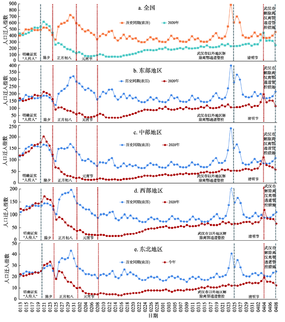
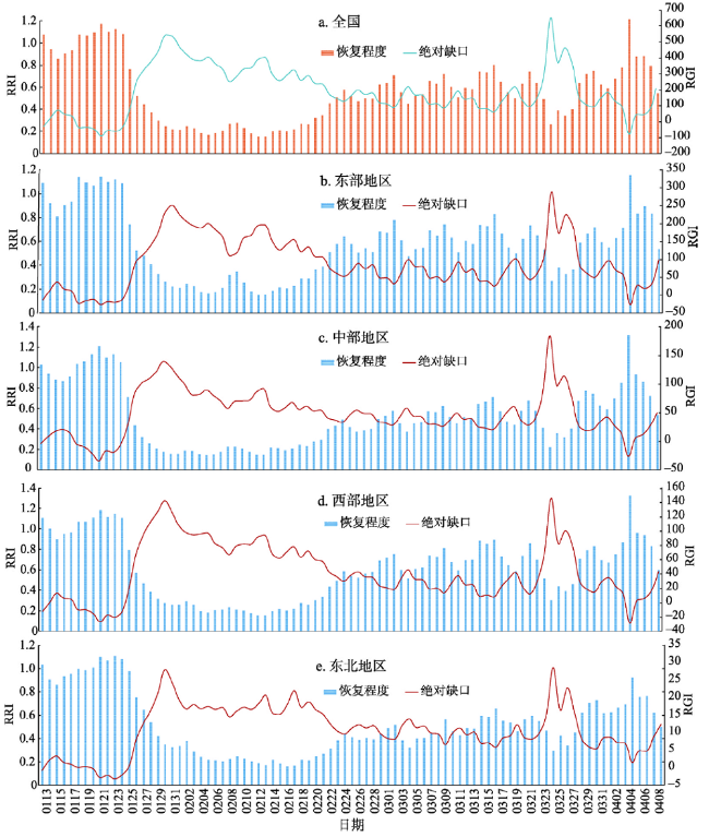
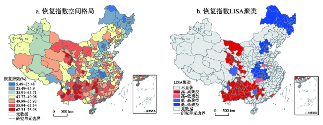
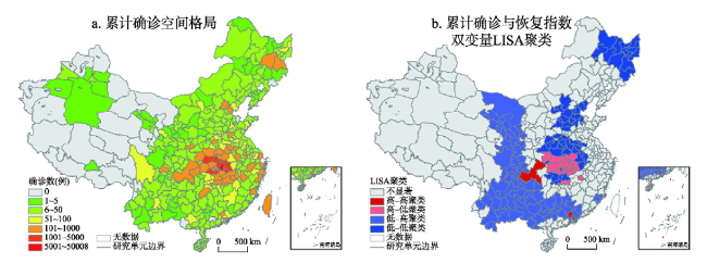
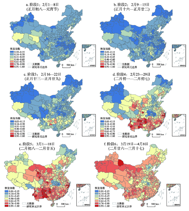
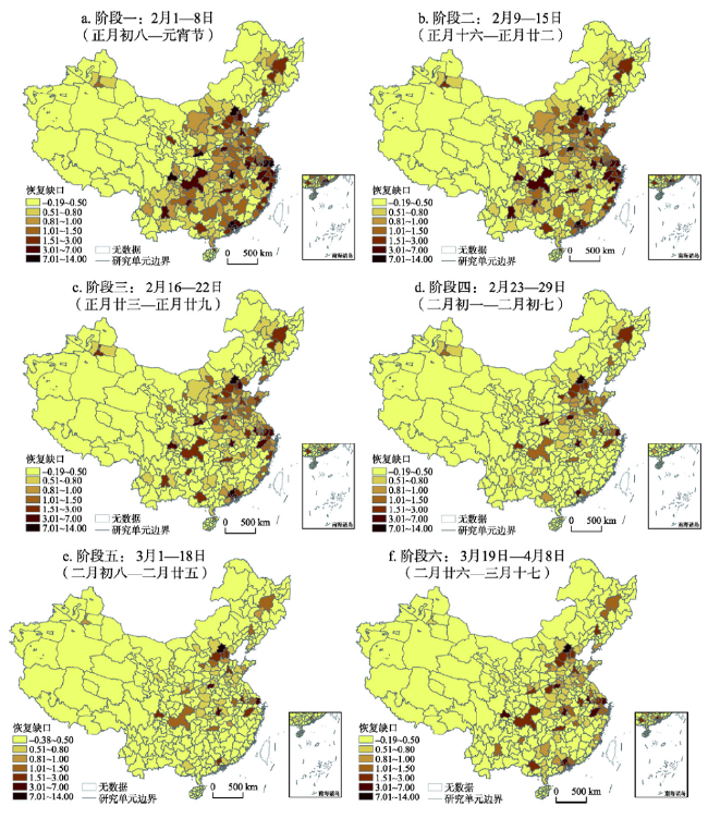
The COVID-19 epidemic in 2020 has a severe impact on China's national economic and social development. Evaluating the short-term impact of the COVID-19 epidemic and the recovery of China's economy and society, as well as revealing its spatiotemporal characteristics, can provide a strong support for the economic situation research and urban restoration of the normalized epidemic prevention and control stage. Based on Baidu migration big data from January 13 to April 8 in 2020 and that of the same period in history, this paper constructs the Relative Recovery Index (RRI) and Recovery Gap Index (RGI). Furthermore, it reveals the daily characteristics, stage characteristics, and spatiotemporal patterns of the short-term impact of the COVID-19 epidemic at multiple scales. The results are as follows: (1) The outbreak did not affect the travel rush before the Spring Festival. The process after the Spring Festival experienced a recovery stagnation period, a rapid recovery period, and a slow recovery period. The overall degree of recovery nationwide rose from less than 20% during the stagnation period to about 60% at the end of the rapid recovery period. The slow recovery period began on March 3, with a recovery index of over 70%. It will take a long time to fully recover to the historical level. (2) The intercity activities on weekends and in holidays were significantly weakened, especially in the central and northeastern regions. (3) The impact of the epidemic on each region is significantly different, in terms of the RRI, the western region > eastern region > central region > northeastern region. (4) The degree of recovery varies significantly between cities. From the Spring Festival to April 8th, the spatial pattern was high in the south and low in the north. According to the severity of the epidemic, Guangzhou, Shenzhen and Chongqing are in the cluster of High confirmed case-High recovery; Hebei, Tianjin, Heilongjiang, Henan, Anhui and Hunan are in the cluster of Low confirmed case-Low recovery. (5) With the effective control of the epidemic, the recovery gap has shifted from the large-scale insufficiency of labor force in the urban agglomerations such as Beijing-Tianjin-Hebei, the Yangtze River Delta, and the Pearl River Delta into the insufficiency in the central cities and some provincial capital cities. The results of this paper show that the use of spatiotemporal big data for real-time impact assessment of major public health emergencies have good application prospects.
TONG Yun , MA Yong , LIU Haimeng . The short-term impact of COVID-19 epidemic on the migration of Chinese urban population and the evaluation of Chinese urban resilience[J]. Acta Geographica Sinica, 2020 , 75(11) : 2505 -2520 . DOI: 10.11821/dlxb202011017
图3 中国城市恢复指数的空间特征(数据截至2020年4月8日)Fig. 3 Spatial features of the RRI in China (as of April 8, 2020) |
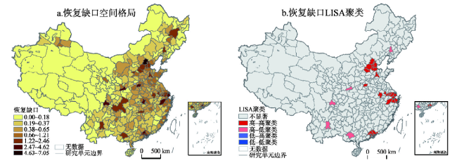
图4 中国城市恢复缺口的空间特征(数据截至2020年4月8日)Fig. 4 Spatial characteristics of RGI in China (as of April 8, 2020) |
| [1] |
[ 龚胜生, 谢海超, 陈发虎. 2200年来我国瘟疫灾害的时空变化及其与生存环境的关系. 中国科学: 地球科学, 2020,50(5):719-722.]
|
| [2] |
[ 张云飞. 统筹推进“美丽中国”建设和“健康中国”建设: 基于防控新型冠状病毒感染肺炎疫情阻击战的思考. 福建师范大学学报(哲学社会科学版), 2020(2):21-26, 167.]
|
| [3] |
|
| [4] |
[ 甄峰, 王波. “大数据”热潮下人文地理学研究的再思考. 地理研究, 2015,34(5):803-811.]
|
| [5] |
[ 程昌秀, 史培军, 宋长青, 等. 地理大数据为地理复杂性研究提供新机遇. 地理学报, 2018,73(8):1397-1406.]
|
| [6] |
[ 易嘉伟, 王楠, 千家乐, 等. 基于大数据的极端暴雨事件下城市道路交通及人群活动时空响应. 地理学报, 2020,75(3):497-508.]
|
| [7] |
[ 龙瀛, 茅明睿, 毛其智, 等. 大数据时代的精细化城市模拟: 方法、数据和案例. 人文地理, 2014,29(3):7-13.]
|
| [8] |
[ 童昀, 马勇, 刘军, 等. 大数据支持下的酒店业空间格局演进与预测: 武汉案例. 旅游学刊, 2018,33(12):76-87.]
|
| [9] |
[ 邓楚雄, 宋雄伟, 谢炳庚, 等. 基于百度贴吧数据的长江中游城市群城市网络联系分析. 地理研究, 2018,37(6):1181-1192.]
|
| [10] |
[ 钟炜菁, 王德. 基于居民行为周期特征的城市空间研究. 地理科学进展, 2018,37(8):1106-1118.]
|
| [11] |
[ 裴韬, 刘亚溪, 郭思慧, 等. 地理大数据挖掘的本质. 地理学报, 2019,74(3):586-598.]
|
| [12] |
[ 祝丙华, 王立贵, 孙岩松, 等. 基于大数据传染病监测预警研究进展. 中国公共卫生, 2016,32(9):1276-1279.]
|
| [13] |
|
| [14] |
|
| [15] |
|
| [16] |
[ 辛妍,
|
| [17] |
|
| [18] |
[ 李德仁, 邵振峰, 于文博, 等. 基于时空位置大数据的公共疫情防控服务让城市更智慧. 武汉大学学报·信息科学版, 2020,45(4):475-487, 556.
|
| [19] |
[ 周成虎, 裴韬, 杜云艳, 等. 新冠肺炎疫情大数据分析与区域防控政策建议. 中国科学院院刊, 2020,35(2):200-203.]
|
| [20] |
|
| [21] |
|
| [22] |
[ 赵梓渝, 魏冶, 王士君, 等. 有向加权城市网络的转变中心性与控制力测度: 以中国春运人口流动网络为例. 地理研究, 2017,36(4):647-660.]
|
| [23] |
[ 冯章献, 张瑜, 魏冶, 等. 基于百度迁徙数据的长春市春运人口流动时空格局与动力机制. 经济地理, 2019,39(5):101-109.]
|
| [24] |
[ 徐腾, 姚洋. 城际人口迁移与房价变动: 基于人口普查与百度迁徙数据的实证研究. 江西财经大学学报, 2018(1):11-19.]
|
| [25] |
[ 叶强, 张俪璇, 彭鹏, 等. 基于百度迁徙数据的长江中游城市群网络特征研究. 经济地理, 2017,37(8):53-59.]
|
| [26] |
[ 蒋小荣, 汪胜兰. 中国地级以上城市人口流动网络研究: 基于百度迁徙大数据的分析. 中国人口科学, 2017(2):35-46, 127.]
|
| [27] |
[ 赖建波, 潘竟虎. 基于腾讯迁徙数据的中国“春运”城市间人口流动空间格局. 人文地理, 2019,34(3):108-117.]
|
| [28] |
[ 刘望保, 石恩名. 基于ICT的中国城市间人口日常流动空间格局: 以百度迁徙为例. 地理学报, 2016,71(10):1667-1679.]
|
| [29] |
[ 塔娜, 曾屿恬, 朱秋宇, 等. 基于大数据的上海中心城区建成环境与城市活力关系分析. 地理科学, 2020,40(1):60-68.]
|
| [30] |
|
| [31] |
[ 徐冬, 黄震方, 黄睿. 基于空间面板计量模型的雾霾对中国城市旅游流影响的空间效应. 地理学报, 2019,74(4):814-830.]
|
| [32] |
[ 王劲峰, 葛咏, 李连发, 等. 地理学时空数据分析方法. 地理学报, 2014,69(9):1326-1345.]
|
| [33] |
[ 刘海猛. 后疫情时代城市发展路径的“变”与“不变”. 中国发展观察, 2020(Z7):123-125.]
|
/
| 〈 |
|
〉 |