
Multi-time scale analysis of water conservation in a discontinuous forest watershed based on SWAT model
Received date: 2019-05-14
Request revised date: 2020-02-10
Online published: 2020-07-25
Supported by
The Foundation of the Key Laboratory of Soil Erosion Process and Control on the Loess Plateau, Ministry of Water Resources(2017003)
National Natural Science Foundation of China(41877167)
Copyright
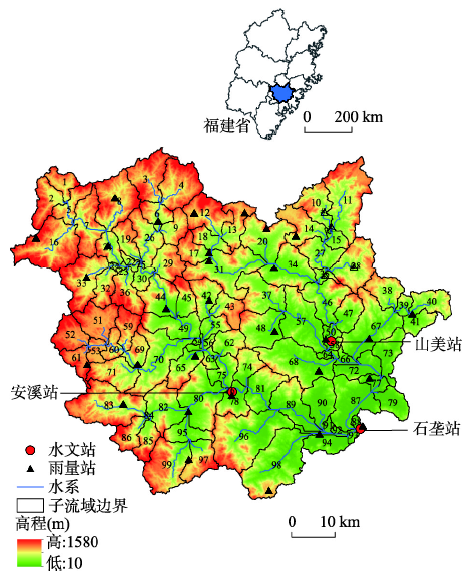
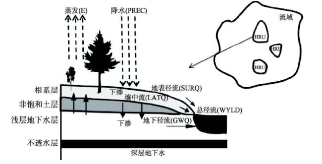
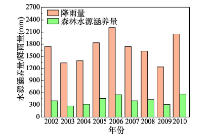
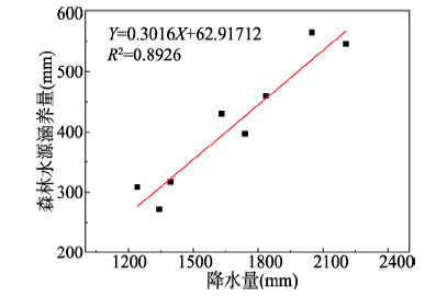
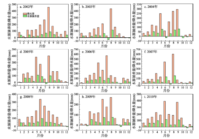
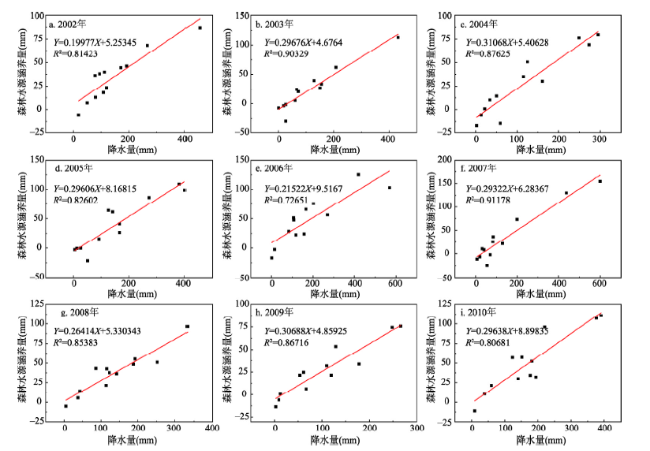
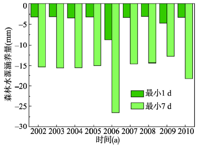
A method has been developed based on the Soil and Water Assessment Tool (SWAT) to quantitatively evaluate the water conservation function of forests and its multi-time scale characteristics in a discontinuous forest watershed. Using this method, we have divided hydrological response units (HRU) based on the spatial distribution of forests, and derived a formula to quantify the water conservation in discontinuous forest watershed based on the water balance method. Here we take the Jinjiang River Basin in southeast coastal China as an example. We constructed SWAT model under land use conditions in 2006 and analyzed the temporal variation of forest water conservation in the study river basin under precipitation conditions from 2002 to 2010. The results show that (1) the SWAT model of the study area is of high accuracy, and the hydrological response unit can accurately reflect the distribution of forest patches when the area threshold is zero. The model provides a new method for evaluation of forest water conservation function in the discontinuous forest watershed using a distributed hydrological model. (2) The annual conservation of forest water in the Jinjiang River Basin was 271.41-565.25 mm. The annual conservation function of forest water is relatively stable, and there was no runoff regulation between consecutive years. The monthly conservation ranged from -29.15 mm to 154.59 mm, which is positive for most months of the year. The forest water conservation was positive in extreme precipitation period, and negative in extremely dry period. This demonstrates the function of forest water conservation in retaining rainwater in wet periods to decrease flood in the river and supplying water in dry periods to supplement the flow at the daily scale was more effective than that at the monthly scale.
LIN Feng , CHEN Xingwei , YAO Wenyi , FANG Yihui , DENG Haijun , WU Jiefeng , LIN Bingqing . Multi-time scale analysis of water conservation in a discontinuous forest watershed based on SWAT model[J]. Acta Geographica Sinica, 2020 , 75(5) : 1065 -1078 . DOI: 10.11821/dlxb202005013
表1 3个站点不同时间尺度模型模拟值与实测值的比较Tab. 1 Model performance: calibrated and validated results for annual, monthly and daily runoff for Shilong, Anxi and Shanmei catchments |
| 时间尺度 | 水文站 | 校准期(2002—2006年) | 验证期(2007—2010年) | |||||
|---|---|---|---|---|---|---|---|---|
| Ens | PBIAS(%) | R2 | Ens | PBIAS(%) | R2 | |||
| 年 | 石垄站 | 0.96 | 7.15 | 0.99 | 0.97 | 5.47 | 0.96 | |
| 安溪站 | 0.96 | -2.4 | 0.99 | 0.93 | 8.2 | 0.96 | ||
| 山美站 | 0.99 | -0.8 | 0.99 | 0.99 | 2.77 | 0.99 | ||
| 月 | 石垄站 | 0.95 | 10.86 | 0.97 | 0.93 | 10.07 | 0.94 | |
| 安溪站 | 0.95 | 1.64 | 0.96 | 0.92 | 12.81 | 0.94 | ||
| 山美站 | 0.97 | 5.43 | 0.97 | 0.98 | 6.87 | 0.99 | ||
| 日 | 石垄站 | 0.87 | 6.87 | 0.86 | 0.82 | 6.07 | 0.83 | |
| 安溪站 | 0.86 | 8.01 | 0.89 | 0.76 | 8.9 | 0.82 | ||
| 山美站 | 0.89 | 2.06 | 0.89 | 0.88 | 3.17 | 0.87 | ||
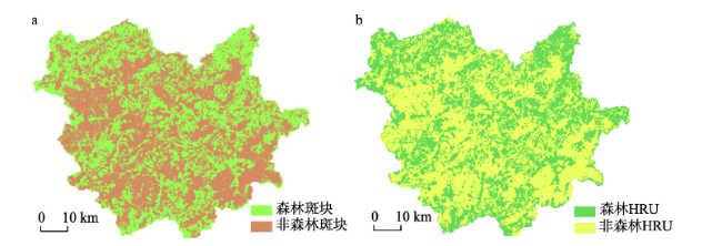
表2 不同土地利用HRU与实际土地利用面积比较Tab. 2 Comparison of different land use HRUs with actual patches when the area threshold is set to 0. |
| 土地利用 | 实际面积(km2) | 模型概化后的面积(km2) | 实际占流域面积比例(%) | 模型概化后占流域面积比例(%) | HRU 数量 |
|---|---|---|---|---|---|
| 耕地 | 460.33 | 461.55 | 9.13 | 9.15 | 403 |
| 旱地 | 157.31 | 156.30 | 3.12 | 3.10 | 301 |
| 森林 | 2805.87 | 2815.75 | 55.65 | 55.85 | 468 |
| 园地 | 1057.30 | 1061.43 | 20.97 | 21.05 | 448 |
| 建设用地 | 388.23 | 391.55 | 7.70 | 7.77 | 426 |
| 草地 | 39.33 | 39.58 | 0.78 | 0.79 | 199 |
| 水域 | 62.01 | 47.63 | 1.23 | 0.94 | 269 |
| 裸地 | 68.07 | 67.96 | 1.35 | 1.35 | 260 |
| 汇总 | 5042 | 5041.75 | 100 | 100 | 2774 |
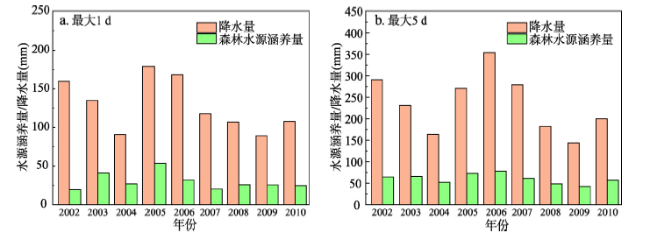
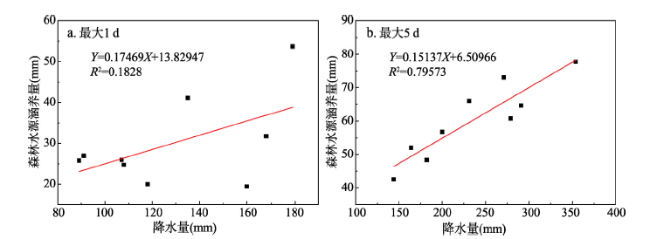
图8 森林水源日涵养量和降雨量差异比较Fig. 8 Comparison of daily forest water conservation and rainfall (a: maximum daily value; b: maximum five-day value) |
表4 不同面积阈值取值条件下各土地利用HRU面积比较Tab. 4 Area comparison of land use HRU under different threshold conditions |
| 阈值 | 不同土地利用HRU的面积(km2) | |||||||
|---|---|---|---|---|---|---|---|---|
| 森林 | 耕地 | 园地 | 建设用地 | 草地 | 旱地 | 裸地 | 水域 | |
| Y000000 | 2805.81 | 460.42 | 1057.05 | 391.71 | 39.44 | 157.23 | 68.23 | 61.86 |
| Y011010 | 2841.36 | 465.21 | 1070.07 | 394.55 | 25.98 | 153.14 | 56.32 | 35.13 |
| Y051010 | 3037.92 | 431.81 | 1137.66 | 338.30 | 2.18 | 70.50 | 21.28 | 2.10 |
| Y101010 | 3276.56 | 347.31 | 1137.16 | 237.83 | 0 | 22.79 | 19.87 | 0.23 |
| Y102010 | 3276.56 | 347.31 | 1137.16 | 237.83 | 0 | 22.79 | 19.87 | 0.23 |
| Y102020 | 3276.56 | 347.31 | 1137.16 | 237.83 | 0 | 22.79 | 19.87 | 0.23 |
| [1] |
[ 于静洁, 刘昌明 . 森林水文学研究综述. 地理研究, 1989,8(1):88-98.]
|
| [2] |
|
| [3] |
|
| [4] |
|
| [5] |
|
| [6] |
|
| [7] |
|
| [8] |
|
| [9] |
[ 侯元兆, 张颖, 曹克瑜 . 森林资源核算. 北京: 中国科学技术出版社, 2005.]
|
| [10] |
[ 司今, 韩鹏, 赵春龙 . 森林水源涵养价值核算方法评述与实例研究. 自然资源学报, 2011,26(12):2100-2109.]
|
| [11] |
[ 王晓学, 沈会涛, 李叙勇 , 等. 森林水源涵养功能的多尺度内涵、过程及计量方法. 生态学报, 2013,33(4):1019-1030.]
|
| [12] |
[ 邓坤枚, 石培礼, 谢高地 . 长江上游森林生态系统水源涵养量与价值的研究. 资源科学, 2002,24(6):68-73.]
|
| [13] |
[ 张文广, 胡远满, 张晶 , 等. 岷江上游地区近30年森林生态系统水源涵养量与价值变化. 生态学杂志, 2007,26(7):1063-1067.]
|
| [14] |
[ 刘璐璐, 曹巍, 邵全琴 . 南北盘江森林生态系统水源涵养功能评价. 地理科学, 2016,36(4):603-611.]
|
| [15] |
[ 唐玉芝, 邵全琴 . 乌江上游地区森林生态系统水源涵养功能评估及其空间差异探究. 地球信息科学学报, 2016,18(7):987-999.]
|
| [16] |
[ 肖寒, 欧阳志云, 赵景柱 , 等. 森林生态系统服务功能及其生态经济价值评估初探: 以海南岛尖峰岭热带森林为例. 应用生态学报, 2000,11(4):481-484.]
|
| [17] |
[ 张佳楠, 张建军, 张海博 , 等. 晋西黄土区典型林分水源涵养能力评价. 北京林业大学学报, 2019,41(8):105-114.]
|
| [18] |
[ 张彪, 李文华, 谢高地 , 等. 北京市森林生态系统的水源涵养功能. 生态学报, 2008,28(11):5619-5624.]
|
| [19] |
[ 曾莉, 李晶, 李婷 , 等. 基于贝叶斯网络的水源涵养服务空间格局优化. 地理学报, 2018,73(9):1809-1822.]
|
| [20] |
[ 丁程锋, 张绘芳, 李霞 , 等. 天山中部云杉天然林水源涵养功能定量评估: 以乌鲁木齐河流域为例. 生态学报, 2017,37(11):3733-3743.]
|
| [21] |
[ 聂忆黄, 龚斌, 衣学文 . 青藏高原水源涵养能力评估. 水土保持研究, 2009,16(5):210-212.]
|
| [22] |
[ 周佳雯, 高吉喜, 高志球 , 等. 森林生态系统水源涵养服务功能解析. 生态学报, 2018,38(5):1679-1686.]
|
| [23] |
[ 王兵, 杨锋伟, 郭浩 , 等. 森林生态系统服务评估规范(LY/T1721-2008). 北京: 中国标准出版社, 2008.]
|
| [24] |
[ 张彪, 李文华, 谢高地 , 等. 森林生态系统的水源涵养功能及其计量方法. 生态学杂志, 2009,28(3):529-534.]
|
| [25] |
|
| [26] |
[ 王纪伟, 刘康, 瓮耐义 . 基于In-VEST模型的汉江上游森林生态系统水源涵养服务功能研究. 水土保持通报, 2014,34(5):213-217.]
|
| [27] |
[ 包玉斌, 李婷, 柳辉 , 等. 基于InVEST模型的陕北黄土高原水源涵养功能时空变化. 地理研究, 2016,35(4):664-676.]
|
| [28] |
[ 王玉纯, 赵军, 付杰文 , 等. 石羊河流域水源涵养功能定量评估及空间差异. 生态学报, 2018,38(13):4637-4648.]
|
| [29] |
[ 潘韬, 吴绍洪, 戴尔阜 , 等. 基于InVEST模型的三江源区生态系统水源供给服务时空变化. 应用生态学报, 2013,24(1):183-189.]
|
| [30] |
|
| [31] |
[ 杨大文, 李翀, 倪广恒 , 等. 分布式水文模型在黄河流域的应用. 地理学报, 2004,59(1):143-154.]
|
| [32] |
[ 王晓学, 李叙勇, 莫菲 , 等. 基于元胞自动机的森林水源涵养量模型新方法: 概念与理论框架. 生态学报, 2010,30(20):5491-5500.]
|
| [33] |
|
| [34] |
|
| [35] |
|
| [36] |
|
| [37] |
|
| [38] |
[ 崔远来, 吴迪, 王士武 , 等. 基于改进 SWAT 模型的南方多水源灌区灌溉用水量模拟分析. 农业工程学报, 2018,34(14):94-100.]
|
| [39] |
[ 王中根, 刘昌明, 黄友波 . SWAT模型的原理、结构及应用研究. 地理科学进展, 2003,22(1):79-86.]
|
| [40] |
|
| [41] |
|
| [42] |
|
| [43] |
|
| [44] |
|
| [45] |
|
| [46] |
|
| [47] |
[ 中野秀章 . 森林水文学. 北京: 中国林业出版社, 1983: 207-212.]
|
| [48] |
[ 林炳青 . 流域景观格局变化对不同时间尺度径流影响的SWAT模拟分析[D]. 福州: 福建师范大学, 2014.]
|
| [49] |
[ 林炳青, 陈莹, 陈兴伟 . SWAT模型水文过程参数区域差异研究. 自然资源学报, 2013,28(11):1988-1999.]
|
| [50] |
|
| [51] |
|
| [52] |
[ 王艳君, 吕宏军, 姜彤 . 子流域划分和DEM分辨率对SWAT径流模拟的影响研究. 水文, 2008,28(3):22-25.]
|
| [53] |
[ 邱临静, 郑粉莉,
|
| [54] |
[ 张利平, 曾思栋, 王任超 , 等. 气候变化对滦河流域水文循环的影响及模拟. 资源科学, 2011,33(5):966-974.]
|
| [55] |
|
| [56] |
[ 陈东, 陈兴伟 . 福建省水资源及其利用比较研究. 福建地理, 2005,20(1):5-8.]
|
/
| 〈 |
|
〉 |