
The characteristics and organizational models of the west circulation network based on the western corridor
Received date: 2018-01-31
Request revised date: 2019-03-13
Online published: 2019-06-20
Supported by
National Natural Science Foundation of China(41701141)
National Natural Science Foundation of China(41430635)
National Natural Science Foundation of China(41471117)
National Natural Science Foundation of China(41501178)
Copyright
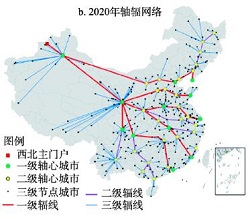
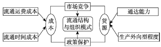
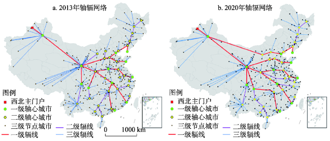
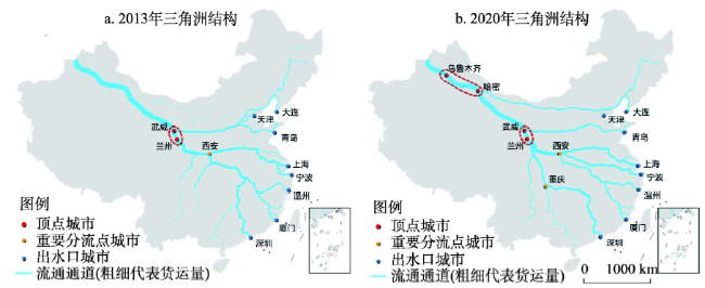
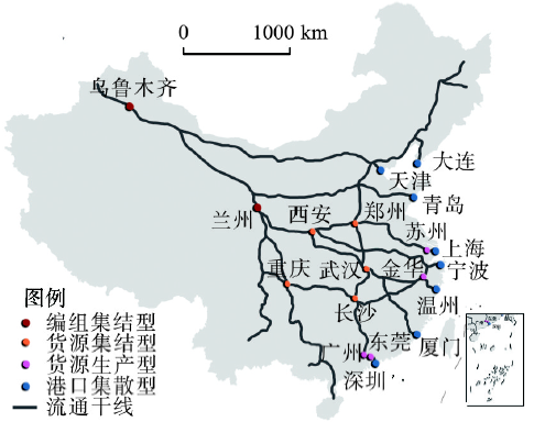
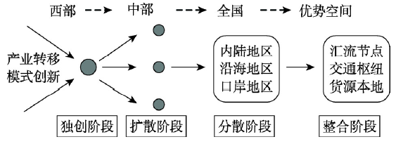
"The Belt and Road Initiative" has activated the westward economic and trade route, and the state has entered a new integrated development stage of land and sea. Previous studies mainly focused on ocean-oriented urban circulation network, however the research on the inland-oriented area needs to be expanded in both content and methods. Using spatial analysis, the paper constructed a framework of "circulation cost-accessibility and the ratio of export-oriented trade-market competition and policy protection-circulation structure and organizational models", and conducted research on the structural features of westward circulation network and organizational models of the circulation of goods based on the west corridor. The research finds that the high grade circulation node shows the overall approximation on the path of the minimum time and the cost of the freight, and the production capacity of flow node shows significant difference under the market competition, the coastal areas nodes, especially the Yangtze River Delta and Pearl River Delta, have significant scale advantages of current flows, but inland nodes with local subsidy policies could radiate the coastal area and launched supply competition. Wuhan, Xi'an, Zhengzhou, Chongqing and Changsha are the best inland nodes of coastal source. According to the characteristics of westward circulation network in the aspects of nodes, lines and flow, the "delta structure" of the country's westward circulation can be extracted. Based on the key nodes of westward circulation network, the paper proposed four patterns: the unified marshalling pattern, key node cities model, "export cities" model and key port cities model. The westward circulation has experienced the initial stage, diffusion stage and dispersed stage, and will enter the integration stage. The leading power of westward circulation will eventually return to the cities located in the advantageous space.
WEN Yuzhao , LU Mengqiu , LI Xiaojian , CHE Bingqing , MENG Deyou , SHI Yanwen . The characteristics and organizational models of the west circulation network based on the western corridor[J]. Acta Geographica Sinica, 2019 , 74(6) : 1205 -1223 . DOI: 10.11821/dlxb201906010
表1 货运铁路速度值设置Tab. 1 The speed value of freight railway |
| 货运速度设定 | 对应的线路条件 | 典型线路 |
|---|---|---|
| 120 km/h | 国铁Ⅰ级或地铁Ⅰ级双线电气化客货共线设计时速为200~250 km/h的快速铁路 | 向莆、昌九、遂渝、遂成等新建的客货共线快速铁路 |
| 80 km/h | 线路等级为设计时速为160 km/h的国铁Ⅰ级或地铁Ⅰ级双线或单线电气化铁路;设计时速为120 km/h国铁Ⅰ级双线电气化货运重载铁路 | 京广、京九、陇海、沪昆等国家电气化骨干铁路干线 |
| 45 km/h | 国铁II级或地铁II级及其以下级别的非电气化铁路; 客运设计时速为120 km/h以下单线铁路; 修建历史较长的双线电气化铁路; 地质地形条件较为复杂的双线电气化铁路 | 宿淮、皖赣等非电气化铁路;正太、焦柳等修建历史较长铁路;鹰厦、峰福、宝成、成昆等沿线地形条件复杂铁路 |
表2 节点城市等级判别指标体系与权重设置Tab. 2 The evaluation index system and weight setting of node cities |
| 一级指标 | 权重 | 二级指标 | 权重 | 三级指标 | 权重 |
|---|---|---|---|---|---|
| GDP | 0.35 | ||||
| 经济发展现状 | 0.22 | 规模工业总产值 | 0.33 | ||
| 固定资产投资总额 | 0.32 | ||||
| 物流需求现状 | 0.39 | 对外出口额 | 1 | ||
| 火车站等级 | 0.45 | ||||
| 基础设施支撑能力 | 0.45 | 公路枢纽等级 | 0.33 | ||
| 港口等级 | 0.22 | ||||
| 物流支撑与服务能力 | 0.39 | ||||
| 铁路货物发送量 | 0.45 | ||||
| 物流服务能力 | 0.55 | 公路货物发送量 | 0.33 | ||
| 水运货物发送量 | 0.22 |
表3 流通节点货流生产能力差异Tab. 3 Production capacity difference of the flow nodes |
| 城市 | 出口总额 (亿美元) | 外向型货流 生产能力类别 | 城市 | 对欧洲出口额(亿美元) | 西向货流 生产能力类别 |
|---|---|---|---|---|---|
| 深圳、上海、苏州 | 1757~3057 | 超强 | 上海、深圳、苏州 | 339.09~428.43 | 超强 |
| 东莞、宁波、北京、广州、天津等(18个) | 294.7~908.6 | 强 | 宁波、重庆、杭州、东莞、金华等(21个) | 50.77~200.08 | 强 |
| 珠海、中山、郑州、嘉兴、南通等(26个) | 61.7~265.8 | 较强 | 惠州、南通、福州、常州、珠海等(31个) | 9.46~42.57 | 较强 |
| 东营、唐山、贵阳、济南、太原等(110个) | 10.5~58 | 较弱 | 贵阳、临沂、昆明、汕头、哈尔滨等(115个) | 1.22~8.94 | 较弱 |
| 广安、湘潭、枣庄、鹰潭、韶关等(185个) | 0.002~9.8 | 弱 | 韶关、盘锦、湘潭、安阳、宝鸡等(172个) | 0.0003~1.17 | 弱 |
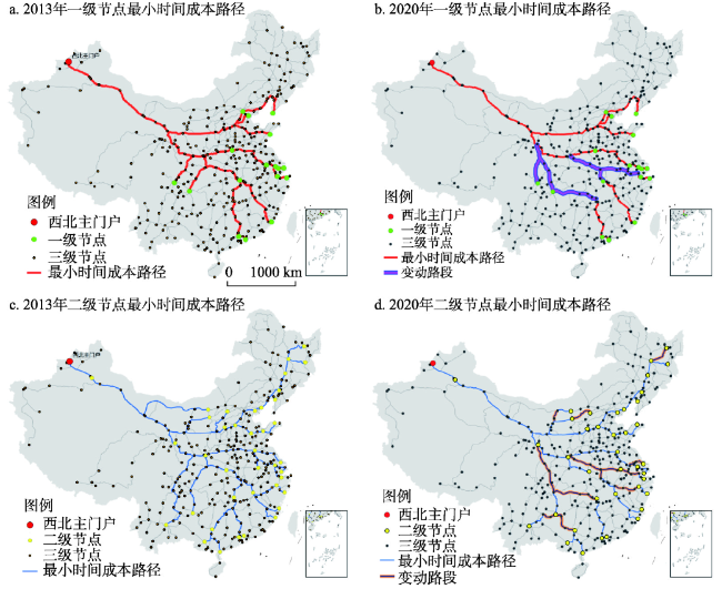
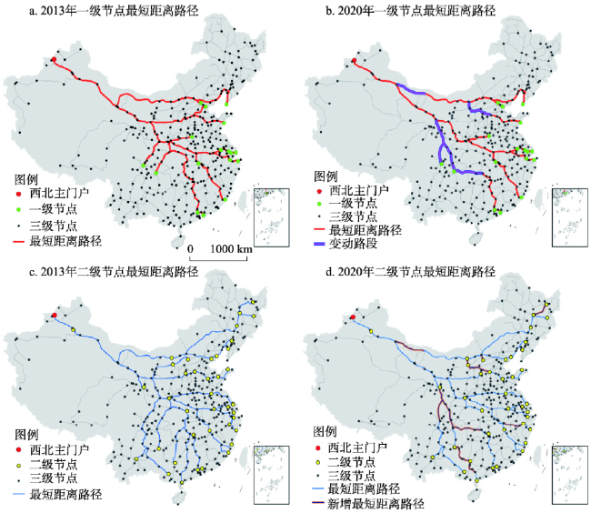
表4 主通道路段途径货流量变化状况Tab. 4 The changes of cargo flow in the main trunk roads of logistics |
| 通道路段 | 途径流量占全网络比例(%) | 变化性质 | |
|---|---|---|---|
| 2013年 | 2020年 | ||
| 重庆—西安/兰州 | 3.43 | 23.77 | 地位上升 |
| 武汉—西安 | 31.80 | 11.46 | 地位下降 |
| 上海—西安 | 42.00 | 28.78 | 地位下降 |
| 石家庄—兰州 | 16.66 | 8.55 | 地位下降 |
| 天津—乌鲁木齐 | - | 8.10 | 地位上升 |
| 杭州—西安 | - | 13.22 | 地位上升 |
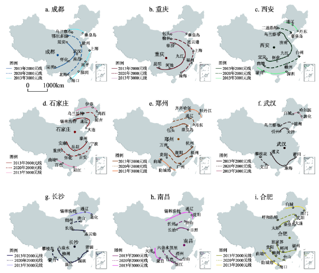
表5 政策保护条件下内陆节点对沿海货源组织条件评价Tab. 5 The organizational capacity of inland nodes to coastal goods under policy protection |
| 内陆 节点 | 整体优势货源方向 | 整体优势方向货流占沿海比例(%) | 节点 等级 | 所处辐 线等级 | 一级辐线沿海 方向数量 | 辐线连接方向货流占沿海比例(%) | 组织货流 综合条件 |
|---|---|---|---|---|---|---|---|
| 成都 | 长三角、珠三角、福建 | 85 | 1 | 1 | 0 | — | 一般 |
| 重庆 | 长三角、珠三角、福建 | 85 | 1 | 1 | 0~1 | 25 | 较好 |
| 西安 | 长三角、山东 | 62 | 2 | 1 | 2~3 | 61~85 | 好 |
| 石家庄 | 长三角、环渤海 | 69 | 2 | 1 | 1~2 | 8~15 | 一般 |
| 郑州 | 长三角、环渤海 | 69 | 1 | 1 | 1 | 47~54 | 较好 |
| 武汉 | 长三角、珠三角、山东 | 86 | 1 | 1 | 1~2 | 14~38 | 好 |
| 长沙 | 长三角、珠三角、福建 | 85 | 2 | 1 | 1 | 25 | 较好 |
| 南昌 | 长三角、珠三角、福建 | 85 | 2 | 1 | 1 | 7~14 | 一般 |
| 合肥 | 长三角、山东 | 62 | 2 | 2 | 0 | — | 一般 |
The authors have declared that no competing interests exist.
作者已声明无竞争性利益关系。
| [1] |
[ 董晓菲 . 大连港—东北腹地系统空间作用及联动发展机理研究[D]. 长春: 东北师范大学, 2011.]
|
| [2] |
|
| [3] |
|
| [4] |
|
| [5] |
|
| [6] |
|
| [7] |
|
| [8] |
|
| [9] |
|
| [10] |
|
| [11] |
|
| [12] |
|
| [13] |
|
| [14] |
|
| [15] |
|
| [16] |
[ 王成金 . 城际集装箱交流枢纽的识别及其物流特征: 以中国铁路运输为例. 地理学报, 2010,65(10):1275-1286.]
|
| [17] |
[ 叶士琳, 曹有挥, 王佳韡 , 等. 基于企业视角的中国集装箱运输组织网络. 地理学报, 2017,72(8):1520-1530.]
|
| [18] |
[ 王佩佩, 王哲, 黄佛君 , 等. 丝绸之路经济带下新疆通道轴辐式物流网络构建. 经济地理, 2016,36(2):125-130.]
|
| [19] |
[ 张闯, 夏春玉 . 城市间流通网络及其形成与演化的微观动力机制研究. 商业经济与管理, 2009(10):5-11.
|
| [20] |
[ 韩增林, 郭建科 . 中国海港空间效应的识别与测度. 地理学报, 2014,69(2):243-254.]
|
| [21] |
[ 曹有挥, 梁双波, 吴威 , 等. 枢纽港口城市港航服务业空间组织机理: 以上海市为例. 地理学报, 2017,72(12):2226-2240.]
|
| [22] |
[ 王伟, 王成金 . 中国沿海港口煤炭运输的空间分异格局及演化. 地理学报, 2016,71(10):1752-1766.]
|
| [23] |
[ 金凤君, 王成金 . 轴—辐侍服理念下的中国航空网络模式构筑. 地理研究, 2005,24(5):774-784.]
|
| [24] |
[ 王姣娥, 莫辉辉, 金凤君 . 中国航空网络空间结构的复杂性. 地理学报, 2009,64(8):899-910.
|
| [25] |
[ 修春亮, 程林, 宋伟 . 重新发现哈尔滨地理位置的价值: 基于洲际航空物流. 地理研究, 2010,29(5):811-819.]
|
| [26] |
[ 刘卫东 . “一带一路”战略的科学内涵与科学问题. 地理科学进展, 2015,34(5):538-544.]
|
| [27] |
[ 王姣娥, 焦敬娟, 景悦 , 等. “中欧班列”陆路运输腹地范围测算与枢纽识别. 地理科学进展, 2017,36(11):1332-1339.
|
| [28] |
[ 王姣娥, 景悦, 王成金 . “中欧班列”运输组织策略研究. 中国科学院院刊, 2017,32(4):370-376.]
|
| [29] |
[ 莫辉辉, 王姣娥, 宋周莺 . 丝绸之路经济带国际集装箱陆路运输的经济适应范围. 地理科学进展, 2015,34(5):581-588.]
|
| [30] |
[ 陆梦秋, 陈娱, 陆玉麒 . “一带一路”倡议下中国陆海运输的空间竞合格局. 地理研究, 2018,37(2):404-418.]
|
| [31] |
[ 古龙高 . 基于陆桥通道视角的“中欧班列”优化与建设的思考. 大陆桥视野, 2015(5):46-49.]
|
| [32] |
|
| [33] |
[ 钟业喜, 陆玉麒 . 基于空间联系的城市腹地范围划分: 以江苏省为例. 地理科学, 2012,32(5):536-543.]
|
| [34] |
[ 赵青松 . 中欧国际铁路班列运行特点、问题及对策: 基于“渝新欧”班列的运行实践. 对外经贸实务, 2015(3):33-35.]
|
| [35] |
[ 王琳 . 多国竞相加入中欧班列运价仍有压缩空间 . 第一财经日报, 2015 -06-23(A04).]
|
| [36] |
Research Group of Ningbo Government Development Research Center. The project design of the construction of Sino-Europe Block Train in coastal areas service center in Ningbo. Ningbo Economy (Sanjiang Forum) , 2017(1):10-16.
[ 宁波市政府发展研究中心课题组. 宁波建设中欧班列沿海集结服务中心的方案设计. 宁波经济(三江论坛), 2017(1):10-16.]
|
| [37] |
[ 尹国康 . 流域地貌系统. 南京: 南京大学出版社, 1991.]
|
| [38] |
[ 陆玉麒, 李平华 . 三角洲顶点城市探讨. 地域研究与开发, 2006,25(1):6-9.]
|
| [39] |
[ 陆玉麒 . 流域中心城市的区位特征: 以南昌为例. 人文地理, 2011,26(4):11-16.]
|
| [40] |
[ 李平华 . 基于顶点城市的三角洲双核型空间结构形成演化研究. 人文地理, 2008,23(5):47-52.]
|
| [41] |
[ 李平华 . 三角洲的顶点城市研究[D]. 南京: 南京师范大学, 2005.]
|
/
| 〈 |
|
〉 |