
A primary exploration of the heritage and cultural values of ancient Chinese maps
Received date: 2015-10-29
Request revised date: 2016-03-22
Online published: 2016-11-28
Supported by
Project of Basic Science & Technological Special Program, No.2012FY120200
Copyright
Ancient Chinese cartography dates back to the third century during the Western Jin Dynasty. Cartography was initiated during this period by Pei Xiu, a prime minister and cartographic expert who posited six principles of cartography. Pei Xiu is known in the West as the father of Chinese Cartography. He oversaw the completion of a "Yugong Diyue map"(similar historical atlas), along with 18 articles and a map of the "Terrain Fangzhang" (AD 224-271). Subsequently, a spate of cartographic initiatives followed, some of which are described below. The "wood Fang-zhang map" (similar to administrative map on the plank) was completed by Xie Zhuang, a minister during the Southern Dynasty (AD 502-557). Emperor Yang of the Sui Dynasty commanded the scholar Cui-ji (AD 550-618) to write the "Quyu Tuzhi" (similar to geographic chronicles, AD 581-600). Jia Dan, a prime minister during the Tang Dynasty was also a cartographic expert who led the initiative to develop a map of "Heinei Huayu" (similar to Asia map, AD 730-805). Shen Kuo, a scientist during the Northern Song Dynasty, led efforts to develop a map of "Shouling" (similar to administrative map, AD 1031-1095). Huang Chang, a cartographer and the director of the Board of Rites during the Southern Song Dynasty, created an original of "Suzhou Stone Carving Astronomic Map" (AD 1190), and between AD 1273 and 1333, Zhu Siben, an expert in cartography and a Xuan-trained master during the Yuan Dynasty, developed a map of "Yu" (similar to administrative map, AD 1273-1333). The Zhenghe navigation chart was completed by Zheng He, a navigator during the Ming Dynasty, while Luo Hongxian, a geographic expert, led efforts to develop an atlas of "Guang Yu" (similar to administrative atlas, AD 1504-1564). Xu Guangqi, an astronomer during the Ming Dynasty was responsible for completing a "Star Barrier Figure" and Wei Yuan, an officer in Gaoyou of Jiangsu province in China, was entrusted by Lin Zexu to compile the "Haiguo Tuzhi" (similar to world geographic atlas, AD 1842-1852) during the Qing Dynasty, and etc. Throughout the sixteenth century, ancient Chinese cartography developed continuously and cumulatively, shaped with the individual characteristics in the field of world cartography. Western latitude- and longitude-based mapping techniques had penetrated China much earlier in AD 1460. Thus, the theories and methods of Chinese and Western mapping systems existed in parallel with each other for over 400 years, entailing some fusion between them. The priceless cultural heritage of Chinese mapping imbues a multitude of famous ancient Chinese maps. These include astronomical figures and atlases (world maps, Chinese maps, regional maps, military maps, water conservancy maps, historical maps, and education maps), charts, and maps of scenic spots. These have hitherto been scattered across the world, housed in well-known map agencies at home and abroad. They form an important part of the global cultural heritage of ancient maps and cartography. Given their high cultural value, it would be important to further explore, extract, and utilize them. Finally, the paper gives preliminary discussion on the rare value, application value, historical value, scientific value and artistic value of ancient Chinese maps.
LIANG Qizhang , QI Qingwen , JIANG Lili , ZHANG An , LIANG Xun . A primary exploration of the heritage and cultural values of ancient Chinese maps[J]. Acta Geographica Sinica, 2016 , 71(10) : 1833 -1848 . DOI: 10.11821/dlxb201610013
Tab. 1 Typical ancient map of China from Western Jin to Yuan Dynasty表1 晋—梁—隋—唐—宋—元留存的代表性古地图 |
| 序号 | 地图名称 | 时间(公元) | 地图类型 | 作者 | 藏图单位 |
|---|---|---|---|---|---|
| 1 | 禹贡地域图 | 224-271年 | 历史地图集(禹—西晋)十八篇 | 裴秀领衔 | 《西晋·裴秀传》 |
| 2 | 地形方丈图 | 224-271年 | 古地形图(1:1800000) | 裴秀领衔 | 《西晋·裴秀传》 |
| 3 | 木制方丈图 | 502-557年 | 梁朝州县图(拼接式) | 梁朝谢庄 | 《南史·谢庄传》 |
| 4 | 区宇图志 | 581-600年 | 中国第一部一统志129卷 | 隋文帝组织 | 史书传载 |
| 5 | 西域图记 | 604-618年 | 西域四十四国 | 裴矩 | 史书传载 |
| 6 | 诸州图经集 | 615年 | 隋代全国性总志100卷 | 隋郎茂撰 | 史书传载 |
| 7 | 海内华夷图 | 730-805年 | 中国与邻近地区中外大地图 | 唐德宗宰相贾耽 | 《旧唐书·贾耽传》 |
| 8 | 元和郡县图志 | 805-820年/唐宪宗元和年间 | 唐代地理总志 | 唐宪宗宰相李吉甫 | 史书传载 |
| 9 | 圆形地图 | 1020-1080年 | 中亚舆图(汉译本) | 马合木德.喀什噶里/《突厥语词典》 | 伊斯坦布尔国立图书馆 |
| 10 | 大宋天下郡守图 | 1086-1093年 | 宋州县图 | 北宋沈括《梦溪笔谈》 | 国家图书馆 |
| 11 | 历代地理指掌图 | 1098-1100年 | 历史地图集(帝喾—宋朝) | 北宋税安礼撰,南宋赵亮夫增补 | 国家图书馆藏明刻本(原图藏日本文库) |
| 12 | 舆地图 | 1044-1130年 | 木质《地理图》 | 北宋黄裳 | 中国古代地图集 |
| 13 | 苏州石刻天文图 | 1044-1130年 | 天文星图(公元1190年刻石) | 北宋黄裳 | 苏州碑林博物馆 |
| 14 | 禹跡图 | 1080-1094年绘制 | 1136年石刻地理图 | 刘豫阜昌七年刻石,1142年俞萀重校 | 陕西省博物馆/镇江博物馆 |
| 15 | 西夏地形图 | 1108年 | 地理图 | 明万历“重校范文正公集” | 国家图书馆 |
| 16 | 九域守令图 | 1121年/北宋 | 宋代州县图(托片) | 北宋荣州刺史宋昌宗立石 | 四川博物馆 |
| 17 | 华夷图 | 1117-1125年绘制/1136年刻 | 石刻地理图 | 唐贾耽《海内华夷图》 | 陕西省博物馆 |
| 18 | 六经图碑 | 1155年 | 历史沿革图碑 | 南宋杨甲编撰《六经图》 | 国家图书馆 |
| 19 | 十五国风地理之图 | 1165年 | 历史沿革图 | 南宋杨甲编撰《六经图》 | 北京图书馆 |
| 20 | 夷贡山川地理图 | 1177年 | 历史沿革图集 | 南宋程大昌 | 北京图书馆 |
| 21 | 契丹地理之图 | 1180年 | 契丹政区图 | 南宋叶隆礼 | 北京图书馆 |
| 22 | 坠理图 | 1190年绘制/1247年石刻 | 两宋疆域地理图 | 南宋黄裳 | 苏州市碑刻博物馆 |
| 23 | 帝王经世图谱 | 1201年 | 图谱式六经著作十卷附图 | 南宋唐仲友 | 北京图书馆 |
| 24 | 陕西五路之图 | 1214年 | 金政区图(1187年) | 陕西汉人(金贞祐二年) | |
| 25 | 《春秋分记》附图 | 1205-1243年 | 历史沿革图(14幅) | 宋宁宗时期程公说 | 台北文渊阁《四库全书》 |
| 26 | 舆地图 | 1315年 | 中国舆图(含周边国家) | 朱思本 | 罗洪先《广舆图》源图 |
| 27 | 声教广被图 | 元末 | 元末舆地图 | 李泽民 | 《混一疆理历代国都之图》源图 |
| 28 | 混一疆理图 | 元末 | 元末舆地图 | 清濬 | 《混一疆理历代国都之图》源图 |
| 29 | 广舆疆理图 | 1360年 | 元末舆地图 | 清濬 | 明叶盛《水东日记》 |
Tab. 2 Typical ancient map of China in the Ming and Qing dynasties表2 明—清留存的代表性古地图 |
| 序号 | 地图名称 | 时间(公元) | 类型 | 作者 | 藏图单位 |
|---|---|---|---|---|---|
| 1 | 大明混一图 | 1389年 | 中国舆图 | 不详 | 中国第一历史档案馆 |
| 2 | 天下诸番识贡图 | 1418年(原图) | 两半球图 | 摹绘本作者莫易仝(1763年) | 明间收藏家刘刚 |
| 3 | 郑和航海图 | 1430年 | 远洋航海图 | 郑和船队 | 北京图书馆 |
| 4 | 大明一统之图 | 1461年 | 中国明代舆图(集) | 李贤、万安 | 北京大学图书馆 |
| 5 | 扬子器跋舆地图 | 1512年 | 中国明代舆图 | 扬子器 | 旅顺博物馆 |
| 6 | 皇明舆图 | 1529年 | 中国明代舆图(集) | 桂萼 | 北京图书馆 |
| 7 | 万里海防图 | 1530-1563年 | 海防图(集) | 郑若曾 | 美国国会图书馆 |
| 8 | 九边图(摹本) | 1534年 | 军事地图(陆防图) | 兵部职方司(原图作者许伦) | 中国历史博物馆 |
| 9 | 广舆图 | 1553-1557年 | 中国舆图(集) | 罗洪先 | 北京图书馆 |
| 10 | 筹海图编 | 1561年 | 海防图 | 郑若曾 | 北京图书馆 |
| 11 | 地理人子须知 | 1564年 | 中国舆图集 | 徐雄志、徐维事 | 中国科学院图书馆 |
| 12 | 乾坤万国全图古今人物事迹 | 1593年 | 世界地图 | 梁輈鐻 (中国传统画法) | 英国菲利普。罗宾(Philip Robinson)藏 |
| 13 | 王泮识舆地图 | 1594年 | 中国舆图 | 王泮识署名说明文字,无作者 | 法国国家图书馆 |
| 14 | 坤舆万国全图 | 1602年 | 世界舆图(椭圆形) | 利玛窦等 | 明尼苏达大学图书馆 |
| 15 | 九边图 | 1602年 | 军事地图(陆防图) | 申勇茂 | 中国历史博物馆 |
| 16 | 乾坤一统海防全图*(摹绘本) | 1605年 | 海防图(集) | 董可威 | 中国第一历史档案馆 |
| 17 | 两仪玄览图 | 1603年 | 世界舆图(八条幅拼图) | 李应试 | 辽宁省博物馆 |
| 18 | 坤舆万国全图(摹绘本) | 1608年 | 世界舆图 | 明宫太监 | 南京博物院 |
| 19 | 三才图会 | 1609年 | 中国舆图(志) | 王圻、王思义 | 国家图书馆 |
| 20 | 东西两半球图(《方舆胜略》附图) | 1610年 | 两半球世界图 | 程百二等 | 北京图书馆 |
| 21 | 武备志 | 1621年 | 综合性兵书 | 茅元仪 | 国家图书馆 |
| 22 | 地球仪 | 1623年 | 中文地球仪 | 阳玛诺、龙华民 | 英国博物馆 |
| 23 | 皇明职方地图 | 1636年 | 中国舆图集 | 陈祖绶 | 国家图书馆 |
| 24 | 边境总图、海防总图 | 1639年 | 天下郡国利病书附图 | 顾炎武 | 国家图书馆 |
| 25 | 地图综要 | 1643年 | 中国舆图集 | 吴学俨、朱绍本 | 国家图书馆 |
| 26 | 今古舆地图 | 1643年 | 历史地图集 | 吴国辅、沈定之 | 美国国会图书馆 |
| 27 | 天下九边分野人迹路程全图 | 1644年 | 世界地图 | 曹君义 | 北京图书馆 |
| 28 | 坤舆全图 | 1674年 | 世界地图 | 南怀仁等 | 河北大学图书馆 |
| 29 | 九州分域图(《禹贡锥指》附图) | 1705年 | 康熙九州舆图 | 胡渭 | |
| 30 | 康熙皇舆全览图 | 1718年 | 中国舆图 | 杜德美等 | 国家图书馆 |
| 31 | 澎台海图 | 1714-1722年 | 海图 | 不详 | 旅顺博物馆 |
| 32 | 雍正十排图 | 1726年 | 中国舆图 | 中西合编 | 中国科学院图书馆 |
| 33 | 沿海全图 | 1731年 | 中国海防图 | 陈伦炯 | 南京博物院 |
| 34 | 封舟出洋顺风针路 | 1756年 | 航海图 (福州至琉球那霸港) | 未注 | 北京图书馆 |
| 35 | 坤舆全图 | 1760年 | 世界地图 | 蒋友仁等 | 中国第一历史档案馆 |
| 36 | 乾隆十三排图 | 1761年 | 中国舆图 | 蒋友仁等 | 北京故宫博物院 |
| 37 | 台湾古地图 | 1787年前 | 台湾地图 | 厦门大学人类学博物馆/台北市国立中央图书馆 | |
| 38 | 七省沿海图 | 1787-1795年 | 中国海防图 | 陈伦炯 | 中国历史博物馆 |
| 39 | 前卫后藏总图 | 1798年 | 中国西藏舆图 | 《西招图略》附图 | 中国科学院图书馆(1827年刻本) |
| 40 | 大清万年一统天下全图 | 1800年 | 中国舆图(集) 清嘉庆五年 | (清)黄证孙原绘(清)晓峰摹绘 | 国家测绘档案资料馆 |
| 41 | 运河全图 | 1821-1825年 | 中国大运河全图 | 未注 | 北京图书馆 |
| 42 | 皇朝一统舆地全图 | 1832年 | 清道光十二年全国舆图 | 李兆洛、董方立 | 北京图书馆 |
| 43 | 历代地理志图 | 1822-1837 | 历史地图集 (禹贡九州—明代) | 六严 | 中国科学院图书馆 |
| 44 | 海国图志 | 1842-1852年 | 世界地图集(75幅地图) | 魏源、林则徐 | 中国科学院地理科学与资源研究所图书馆 |
| 45 | 皇舆全图 | 1844年 | 中国舆图 | 邹伯奇 | |
| 46 | 万国大地全图 | 1845年 | 世界地图 (赤道两侧半球图) | 叶子佩 | 河北省石家庄博物馆 |
| 47 | 东南洋大洋海各岛图(38幅) | 1848年 | 《瀛环志略》附图 | 徐继畲 | 国家图书馆 |
| 48 | 大清一统舆图 | 1863年 | 大清舆图志 | 胡林翼等 | 国家图书馆 |
| 49 | 皇朝中外一统舆图 | 1863年 | 清同治2年中国舆图(集) | 胡林翼、严树森 | 国家测绘资料档案馆 |
| 50 | 历代舆地图 | 1863年 | 历史地图集 | 杨守敬 | 国家测绘资料档案馆 |
| 51 | 地球五大洲全图 | 1875年 | 世界地图 | 邝其照 | 中国地图出版集团 |
| 52 | 万国舆图 | 1886年 | 世界地图 | 陈兆桐 | 中国地图出版集团 |
| 53 | 皇朝一统舆地全图 | 1898年 | 中国舆图(清光绪24年) | 六承如、清 节 | 北京图书馆 |
| 54 | 皇舆全图 | 1899年 | 中国舆图集 | 光绪会馆会典图 | 国家图书馆 |
| 55 | 中外舆地全图 | 1903年 | 世界地图 | 邹代钧 | 中国地图出版集团 |
| 56 | 皇朝直省地舆全图 | 1904年 | 光绪30年中国舆图(集) | 邹代钧编 | 国家测绘资料档案馆 |
| 57 | 水经注图 | 1905年 | 水道专题图集 | 杨守敬等 | 国家测绘资料档案馆 |
| 58 | 二十世纪中外大地图 | 1906年 | 世界地图集 (光绪32年) | 周世棠、孙海环 | 国家测绘资料档案馆 |
| 59 | 大清帝国全图 | 1908年 | 光绪34年中国舆图(集) | 商务印书馆 | 宁夏博物馆藏 |
2.1 西晋至元代古地图—中国古代地图科学起源与完善 |
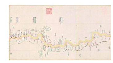
Fig. 1 Ancient map of Yelow River (part)图1 黄河图(局部) |
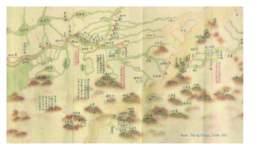
Fig. 2 Ancient map of the Grand Canal (part)图2 大运河图(局部) |
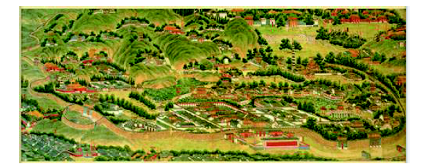
Fig. 3 Ancient map of a summer resort图3 避暑山庄图(局部) |
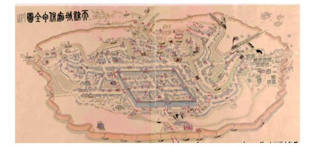
Fig. 4 Ancient map of Tianjin bao-jia system between urban and rural areas图4 天津城乡保甲全图 |
The authors have declared that no competing interests exist.
| [1] |
[
|
| [2] |
[
|
| [3] |
[
|
| [4] |
[
|
| [5] |
[
|
| [6] |
[
|
| [7] |
[
|
| [8] |
[
|
| [9] |
Beitu Rare Book TeCangBu Ancient Map Group. Ancient Map to Record. Beijing: The National Library Press, 1997.
[北图善本特藏部舆图组: 舆图要录. 北京: 国家图书馆出版社, 1997.]
|
| [10] |
Zhen Xihuang. The Ancient Atlas (City) in China. Xi'an: Xi 'an Map Publishing House, 2005.
[
|
| [11] |
[
|
| [12] |
[
|
| [13] |
[
|
| [14] |
[
|
| [15] |
[
|
| [16] |
[
|
| [17] |
[
|
| [18] |
[
|
| [19] |
[
|
| [20] |
[
|
| [21] |
Quanjin (North Korea). The Postcript, for the Mixing Jiangli Map of National Capitals of All Previous Dynasties. 1402.
[权近[朝]. 混一疆理历代国都之图·跋. 1402.]
|
| [22] |
[
|
| [23] |
[
|
| [24] |
[
|
| [25] |
[
|
| [26] |
[
|
| [27] |
[
|
| [28] |
[
|
| [29] |
[辛德勇. 准望释义. 刊唐晓峰主编《九州》第四辑. 北京: 商务印书馆, 2007.]
|
| [30] |
[
|
| [31] |
[
|
| [32] |
[
|
/
| 〈 |
|
〉 |