The earth is a system consisting of lithosphere, hydrosphere, pedosphere, biosphere, and atmosphere, and the water cycle process is the link between these spheres. Maintaining a healthy water cycle is key to achieving sustainable development. The water cycle is not an independent natural process, and solutions to water problems associated with the water cycle typically involve all spheres of the earth system and all aspects of the economy and society. In this study, we discuss the water cycle research from the perspective of the earth system, taking the three topics of forest-water relationship, water cycle change prediction, and comprehensive water cycle research as examples, for the reference of water science colleagues.
The water cycle in a river basin has been increasingly influenced by intense human activities along with the progress of human civilization and continuously growing water intake, revealing itself to complex natural-artificial dualistic characteristics. This study elaborates on the origin and development, scientific issues, and framework system of the natural-artificial dualistic water cycle theory in a river basin, as well as the scientific connotation of five dimensional attributes of water resources from the new perspective of dualistic water cycle, i.e. resources, environment, ecology, society, and economy. After that, key technologies based on the dualistic water cycle theory are proposed, and the frontier directions and development trends of research on water resources are summarized. This study intends to promote the research on water cycle in the river basin, hydrography, and the subject of hydrology and water resources.
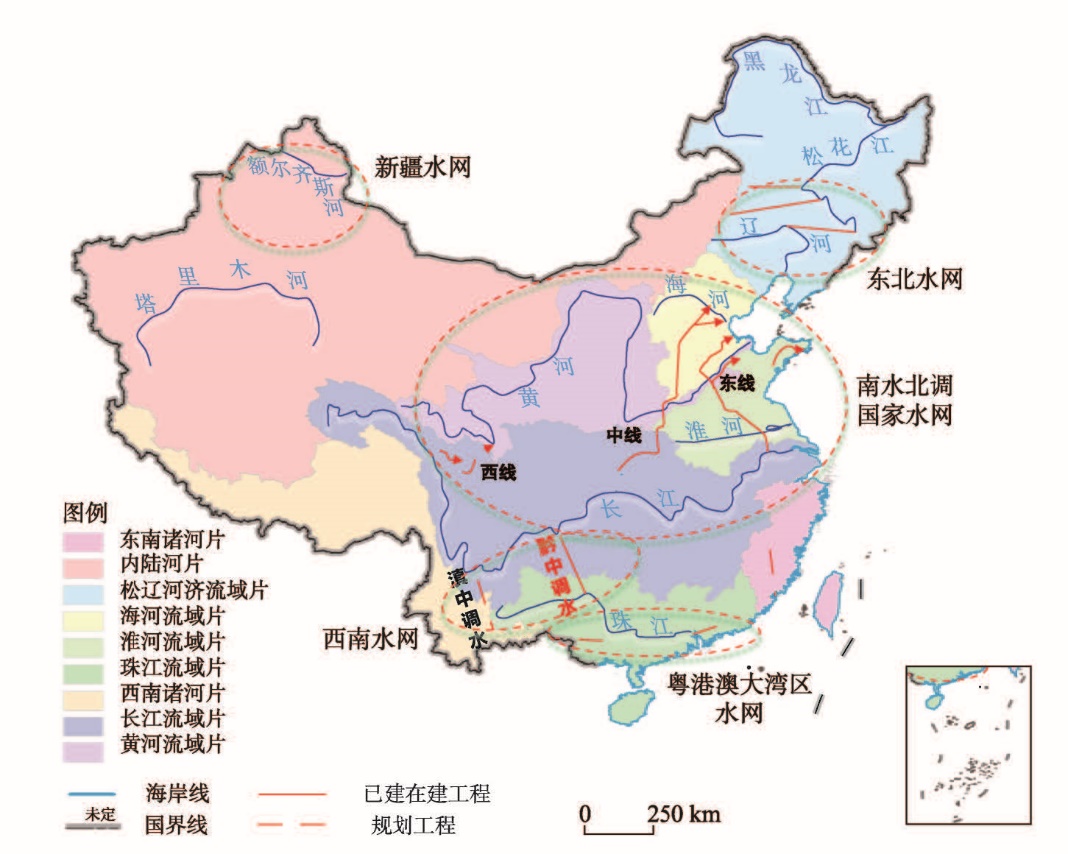
The national water network project is a major strategic deployment in the 14th Five-Year Plan (2021-2025) and the Outline of the 2035 Vision Goals. However, under the influence of global changes, it is facing new opportunities and challenges. Based on the analysis of the background of climate, geography and economic and social development and the characteristics of unbalanced distribution of soil and water resources, this paper has completed three research works. It studies the relationship between supply and demand of water resources in the changing environment. Then it analyzes the planning and layout of the national water network and the effectiveness of the typical water network. Finally, some problems and countermeasures in the planning and construction of the national water network are discussed. Research shows that the impact of global change is more and more prominent. As the country enters the stage of high-quality development, people have higher requirements on the quality and guarantee of water supply. Moreover, the construction of national and regional water networks is an important measure to cope with the impact of environmental change and improve national water security. The construction of the national water network can significantly improve the guarantee of water supply and irrigation, flood control and drainage capacity, and enhance the quality of natural river and lake water environment, but it still has room for optimization and improvement. We need to coordinate regional "water-soil-air-gas" and "man-land" relations, strengthen scientific and technological innovation in the construction of the national water network, improve the comprehensive benefits of ecological environment and economic development of the project, and support the construction of national ecological civilization and high-quality development.
Global warming and urbanization aggravates the disaster risk of regional rainstorm and flood, and seriously threatens the security and development of regional economy and society. The "7·20" rainstorm and flood in Zhengzhou is the urban waterlogging disaster with the most casualties, the heaviest economic losses and the greatest disaster impact in a single city in China in the past 10 years. In this paper, we systematically analyzes the characteristics and causes of the "7·20" rainstorm and flood disaster. Focusing on the main problems of rainstorm and flood disaster prevention, the shortcomings of meteorological and hydrological monitoring and early warning are clarified. Finally, the key strengthening directions of weather forecast and early warning, hydrological monitoring and early warning, and new technology application in the prevention of urban rainstorm and flood are pointed out, in order to provide support for urban flood disaster prevention and intelligent management.
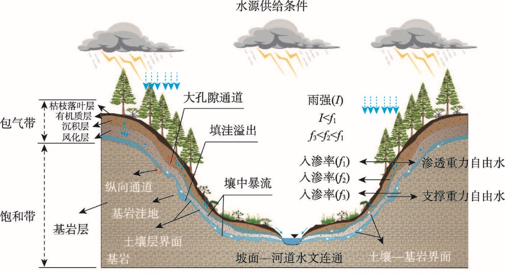
Subsurface stormflow is a special form of subsurface flow in the vadose zone of steep slopes in mountainous and hilly regions, and it is also one of the most important runoff generation mechanisms in the process of flash flood formation. However, the systematic summary on the scientific connotation, mechanisms, and disaster-causing characteristics of the subsurface stormflow in current research is very rare and this limits the development of the theoretical system of runoff generation, routing, and modeling methods of flash floods. Herein, we clarify the scientific connotation and definition of subsurface stormflow based on the division of the development periods of the subsurface stormflow research around the world as well as the analysis of physical processes for the runoff generation. Meanwhile, three physical conditions for the occurrence of subsurface stormflow, together with their influences on the nonlinear response process, are highlighted. The influences of the subsurface stormflow on the dynamic development of flash floods, landslides, and debris flow hazards are analyzed and summarized. Finally, three key research directions are proposed: water transport processes and hydrological connectivity mechanism of the macropores in the vadose zone, processes and mechanisms of water exchange at the geotechnical channel interfaces inside the slopes, and the formation mechanism for flash flood from multiple runoff generation processes with complex slope topography conditions. This work can provide new research perspectives for the formation mechanism and hydrological theoretical framework of flash floods in complex mountainous regions, and better support the national scientific and technological needs for flash flood forecast as well as disaster prevention and mitigation.
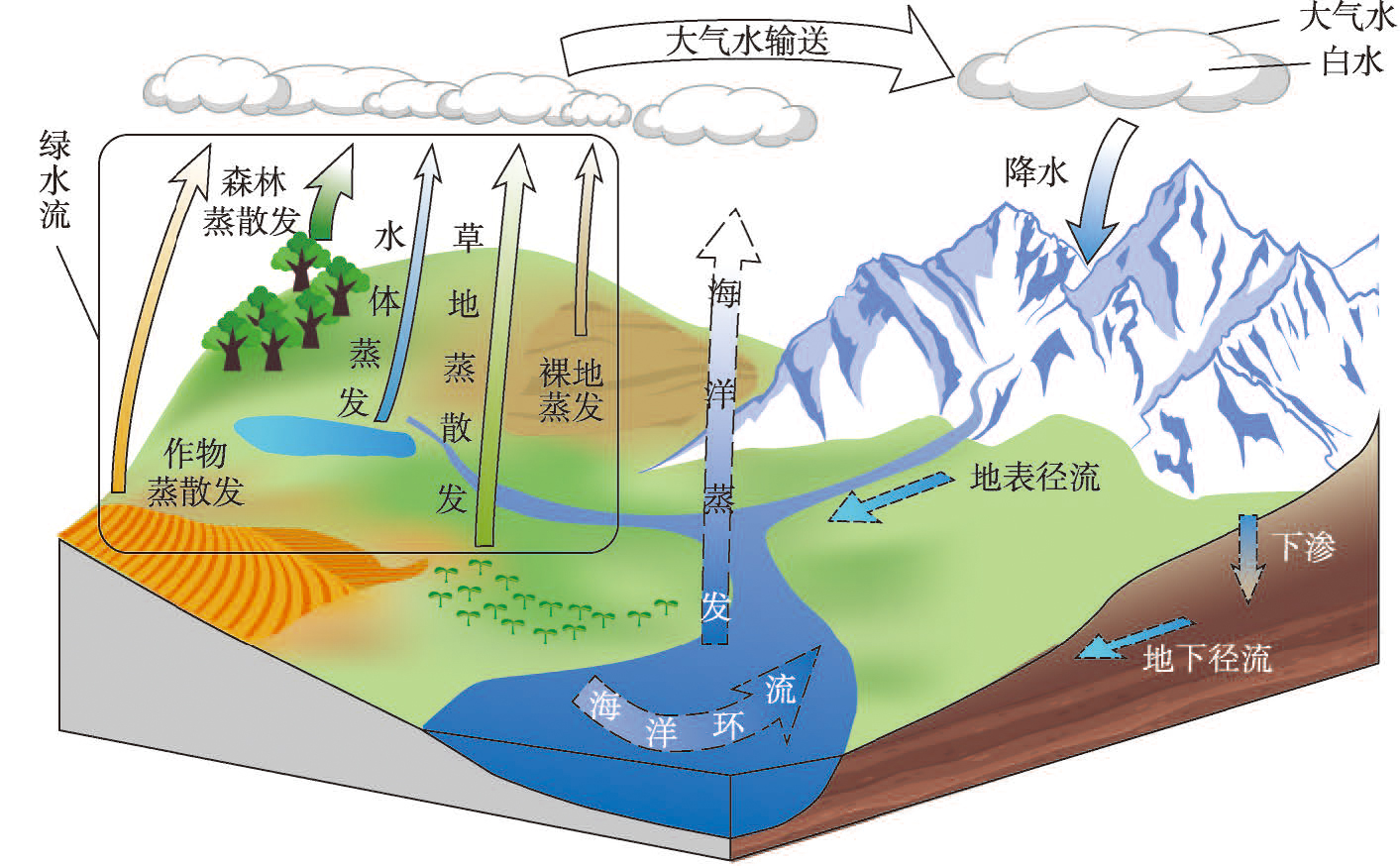
Terrestrial recycling of green water, which is created through a continuous cycle of evapotranspiration, atmospheric transport, and terrestrial precipitation, serves as bridges connecting hydrosphere, atmosphere, biosphere, and anthroposphere. Limited knowledge of terrestrial recycling may underestimate the impact of human activities on water and ecology. This study focuses on the structure of China's green water recycling (CGWR) and quantifies the contributions of natural and human ecosystems. Results indicate a high green water recycling ratio (50.4%) and a large recycled amount (2.75 trillion m3/a) over China, with significant south-to-north transport structures over eastern China, southwest-to-northeast transport structures from southwestern China to northern China, and high self-recycling structures in western China. The grassland-dominated Qinghai-Tibet Plateau provides the largest amount of green water (about 800 billion m3/a) and serves as the most critical region for CGWR. The forest-dominated southern hilly region and Yunnan-Guizhou-Sichuan region play a crucial role in supplying green water to a wide area of China. The cropland-dominated Middle-Lower Yangtze Plain and the grassland-dominated Loess Plateau are the key hubs for south-to-north and southwest-to-northeast transport of green water. The structure of CGWR is driven by large-scale geosystems such as ecosystems and atmospheric circulation systems, and has strategic implications in the following three aspects. First, CGWR serves as the "domestic cycle" of water, based on which a general domestic-level water governance framework can be established. Second, CGWR is a representative picture of the water-related processes in the Mountain-River-Forest-Farmland-Lake-Grassland-Desert (MRFFLGD) system and serves as a critical pivot to actualize the conservation and improvement of the MRFFLGD system. Finally, CGWR, together with inter-basin water resources transfer and virtual water transfer, forms a complete picture of China's inter-basin water transfer. The scientific coordination and integration of the three processes present a new approach for achieving spatial equilibrium between China's water resources and economic development.
Since the founding of New China in 1949, Chinese hydrography has gone through four major development stages, and a series of original achievements have been made in river hydrology and hydrological planning, hydrological experiments and hydrological analysis, water cycle mechanism and hydrological modeling, and comprehensive research on water systems and socioeconomics. This study describes the research characteristics of different development stages of hydrography and reviews the history of hydrographic research in China, aiming to inspire contemporary hydrographic research and promote the growth of young scholars in hydrography.
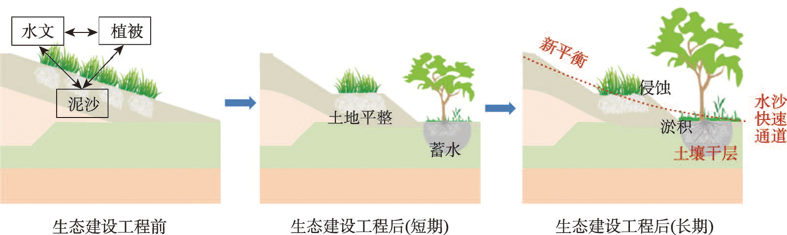
The middle reaches of Yellow River basin, with a fragile ecological environment, are vulnerable to serious flood and drought disasters. In recent years, the controls on soil and water loss in the middle reaches of the Yellow River have been steadily improving under the influence of human activities such as large-scale terrace construction and vegetation restoration projects. These soil and water conservation measures play an important role in flood control, drought relief and disaster reduction. However, at the same time, vegetation construction in the middle reaches of the Yellow River has led to the intensification of dry soil layers, a decrease in runoff and sediment yields, and an increased hydrological drought risk. Urban expansion has also led to drastic change in this disaster-prone environment, including an increased rainstorm and flood peaks in urbanized areas, and increased flood and drought risks. In the middle reaches of the Yellow River basin, the hydrology, sediment and vegetation evolution is highly inter-connected and co-developed. With disturbance from human activities, a new hydrology-sediment-vegetation balance will form. At present, however, the co-evolution processes and mechanisms of the hydrology-sediment-vegetation balance in the basin under a changing environment is not clearly understood. The impact of large-scale distributed human activities such as terrace construction, vegetation restoration projects and urban expansion, on flood and drought disaster risks needs to be scientifically assessed. An intelligent eco-hydrological model of the Yellow River middle reaches under a changing environment should be developed to predict the long-term subsequent impact of large-scale human activities on flood and drought disaster risks. These improvements can provide scientific and technological support for the coordinated development of ecological construction and water conservancy projects in the middle reaches of the Yellow River, serving the effective prevention and mitigation of flood and drought disaster risks.
The prediction and estimation of surface runoff are core research topics in hydrology and geography, with important implications for water resource management and planning. Traditional research relies on measured surface runoff for model calibration and parameter transfer to predict runoff in ungauged basins. However, when measured runoff is scarce or disturbed by strong human activities (such as dam regulation), the ability of parameter transfer is limited, resulting in insufficient runoff prediction capacity. Remote sensing data, with its spatial and temporal continuity, and without being restricted by the observation time series of surface runoff, provides a new approach for runoff prediction. This article explores the method of calibrating hydrological models with remote sensing data in 84 basins in China. Different combinations of remote sensing evapotranspiration, water storage, and soil water data were used to evaluate the potential of predicting runoff by calibrating the hydrological models directly. The results showed that the new method of constraining hydrological models based on grid-based evapotranspiration data with bias correction has great potential for application in both arid and humid areas of China. Grid-based model constraint has a more obvious advantage over lumped model constraint, and multiple hydrological models should be used to enhance the application potential of this method in different basins. The runoff prediction capability and application potential of this method have spatial variability and should be tailored to local conditions to effectively leverage the advantages of remote sensing data.
Remote sensing in hydrology is a crossing field of hydrology and remote sensing. It not only includes remote sensing retrieval models for water cycle factors, but also covers remote sensing hydrological models which serve for calculating the process of hydrology. This review focuses on the past, present and future development of remote sensing hydrological model by using the meta-analysis method and collecting related research in the past 40 years. The results show that remote sensing hydrological model has played a key role in remote sensing hydrology since the 1970s in the world. In China, the researchers of remote sensing in hydrology keep pace with global scientists, and prominent achievements include the concept generation about the remote sensing hydrology, promotion of the combination between remote sensing and hydrology and development of remote sensing hydrological models. In the future, by the help of enhanced information technology, the remote sensing hydrological models will pay more attention to the runoff monitoring by using remote sensing, the intelligent web of hydrological sensors, hydrological analysis in the data scarce watersheds, and the precise simulation of the water flow, water quality as well as the water ecology.
Most of Asian major international rivers originate from China. Their abundant transboundary water resources play an important role in regional "water-energy-food-ecology" security. In recent decades, influenced by global change, especially by the construction of large hydraulic and hydroelectric engineering, the changes in hydrological and ecological processes and their transboundary impacts in the international river regions have attracted more and more attention. The research on these issues in China has achieved prominent results in several aspects, including the changes in hydrological and ecological processes and their attributions, the transboundary impacts and risk regulation, the "water-energy-food-ecology" nexus in transboundary watersheds, and the construction of transboundary water resources coordination mechanism to adapt to global changes. In the face of the increasing risks of transboundary water security and ecological security under global change, the hydro-geographical research on international rivers needs to make use of space-air-ground integrated monitoring technology, modern spatial geographic information technology, intelligent technology, and so on. By providing quantifiable, participatory, and public results, these researches can better provide scientific basis and decision support for the rational utilization of international rivers and geopolitical cooperation, health maintenance and risk control, transboundary water diplomacy and environmental diplomacy.
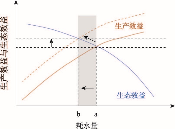
Water shortage is becoming a key factor of agricultural sustainable development in China, and threatening food security. It is an urgent need to establish an integrated water saving framework, including theory and related countermeasures, to support society for seeking a better and sustainable solution. In the this paper, we proposed an integrated agricultural water saving study framework from the perspective of geographical science, and introduced how it was applied to pursue the pathways to sustainable agricultural water utilization and solve the groundwater depletion issue in the North China Plain (NCP), where groundwater is suffering most severe depletion due to irrigation. We proposed a conceptual model of regional agricultural water consumption and its productive and ecologic effects, enlarged the scope of "SPAC interface regulatory theory for agricultural water saving", and established a combined "water saving" and "water adaptive" agriculture research framework, namely, the integrated water saving agricultural study. We applied this integrated water saving study in the NCP as a typical case. Firstly, the evapotranspiration (ET) from a wheat-maize double cropping field was quantified as 710 mm/a, the net water deficit is 220 mm/a, based on a 13-year field measurement of water fluxes and budget. It is necessary to achieve water balance at a farmland scale so as to change the current double cropping system to the alternatives, such as three harvests in two years or even monoculture system. At regional scale, under the precondition or scenario of groundwater zero depletion, which could be achieved through reducing planting area and optimizing planting structure, the production of wheat can only meet 75% of the demand for grain self-sufficiency in the Beijing-Tianjin-Hebei region, based on the model simulation. With the current agricultural technology, we have to rely on import of water or food from external basins to bridge the deficit if we want to pursue high agricultural productivity without groundwater depletion. We quantified the apparent water-saving potential by analyzing ET partitioning structure, i.e. E and T, through combining observation and modeling, and further interpreted the major soil depths for evaporation loss (top 0-20 cm layer) and crop root uptake (top 0-40 cm layer). Then, we developed the sub-surface drip irrigation technology, which set up the drip line at 20-40 cm depth below the ground surface with intervals of 80-100 cm according to the soil texture. Compared with the surface irrigation, the sub-surface drip irrigation could reduce ET of wheat and maize season as 88 mm and 60 mm, respectively, without reduction in yield. The water saving effect is equivalent to 1480 m3/hm2. We believe that this advanced water-saving technology will have a significant positive effect on water budgets of optimizing the planting structure and cropping system, so as to achieve the sustainable goals for both the agricultural production and groundwater conservation. In this study, we also appeal that we should make more efforts on studying water resource yield, transformation, and utilization in dimension of both quantity and quality under a changing environment in future.
China's water resources shows an uneven distribution pattern of shortage in the north and abundance in the south, and the trans-basin water diversion is an effective solution to alleviate the uneven distribution. The South-to-North Water Diversion Project (SNWD) is an important strategic infrastructure to alleviate the shortage of water resources in the northern China, optimize the allocation of water resources, and improve the ecological environment. The planning and construction of the SNWD lasted more than 70 years from the initial proposal of the scheme concept to the completion of the first phase of the project. Key issues, such as optimal allocation of water resources, impact on the ecological environment, and project construction management mechanism have been studied deeply, and a series of key results have been applied to the preliminary demonstration of the SNWD, and to help high-quality planning and construction of the SNWD. In 2014, the first phase of the SNWD was officially opened, marking that the project had changed from a grand concept to a great project, and entered the stage of engineering practice from scientific research. For the 9 years since the project opened, the comprehensive benefits of the project have been continuously demonstrated. This paper comprehensively sorts out the series of scientific research results on several key issues of the high-quality development of the SNWD. Then the practical results of the SNWD in optimizing the water resource allocation pattern, improving the water safety guarantee capacity of the water receiving area, and promoting the protection and restoration of the ecological environment along the routes were systematically summarized. Finally, we put forward the thinking and prospect of the follow-up construction and operation of the project.
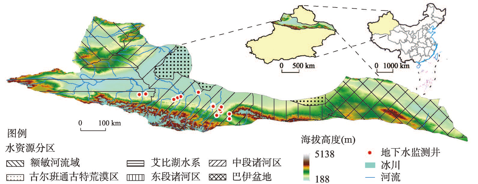
Located in Xinjiang Uygur Autonomous Region, at the national gateway to the Asia-Europe Bridge, the northern slope of the Tianshan Mountains (NSTM) has been experiencing rapid economic development. The oasis economy and irrigated agriculture of NSTM are highly dependent on groundwater. Therefore, it is of great significance to reveal the spatiotemporal evolution of groundwater storage for regional sustainable development. However, long-sequence and high-resolution groundwater observations are relatively scarce on regional scale, which makes the analysis extremely challenging. Based on reconstructed terrestrial water storage anomaly data, ERA5-Land reanalysis data and other auxiliary data such as soil texture, elevation, vegetation index and glaciers, a random forest downscaling model was developed to retrieve high-resolution (8 km) groundwater storage anomaly (GWSA) of NSTM from 1990 to 2020, with which the spatiotemporal evolution of groundwater storage was analyzed. The temporal variation of our GRACE (Gravity Recovery and Climate Experiment)-based GWSA was in high agreement with that of in-situ groundwater level data. The correlation coefficient between GWSA and in-situ data reached a maximum of 0.68. Groundwater storage in NSTM exhibited significant intra- and inter-annual variability, which was higher in spring and summer and lower in autumn and winter, with the peak occurring in June and the minimum in October. Groundwater storage in more than 85% of the NSTM declined significantly during 1990-2020, with a rate of -0.38 cm/a. Groundwater storage in the Ebinur Lake and Central Rivers declined most dramatically, while that in the Emin River was almost constant. The declining rate was the greatest in cropland, followed by grassland, and least in bare land. Increasing demand for water in agriculture was the main driver of groundwater depletion over the past three decades. Compared with seasonal and sub-seasonal variability, long-term variability was the dominant pattern of temporal variability of groundwater storage in NSTM. As for the Emin River, it was jointly dominated by long-term, seasonal and sub-seasonal variability. In particular, it is worth noting that one of the challenges in estimating GWSA in glacier-covered areas is the lack of long-sequence and high-resolution glacier mass data, and most previous studies have ignored the influence of glaciers. This paper showed that ignoring the influence of glaciers would lead to an overestimation of the average groundwater storage change rate in NSTM by at least 27.56%, which needs to be taken seriously.
As global temperatures continue to rise, the impact of water availability on vegetation productivity remains unclear. This study aims to assess the long-term trends of vegetation productivity response to wet and dry changes and the time-scale thresholds of vegetation response in China from 1982 to 2018, which will be important for reducing the management costs of terrestrial ecosystems and achieving the goals of carbon peaking and carbon neutrality. Results show that: (1) Water stress on vegetation productivity in China has increased throughout the study period. (2) In multiple time scale dry and wet variations, 61.18% of the vegetated cover areas had water deficit significantly inhibiting vegetative photosynthesis. In contrast, 28.29% of the vegetated cover areas had water surplus significantly inhibiting vegetative photosynthesis. (3) The minimum response time for vegetation productivity significantly stressed by aridification has been shortened, while the maximum response time for vegetation productivity significantly constrained by water surplus has been lengthened. These observations indicate that it became easier for aridification to suppress vegetation productivity effects and more difficult for the water surplus to produce suppressive effects on vegetation productivity. Consequently, the water constraint on vegetation productivity in China has been intensifying over the past 37 years. These findings shed light on the evolving trend of water availability in the face of ongoing climate warming, providing a scientific basis for understanding the coupling relationship between water and carbon, as well as the water-carbon cycle.
Transpiration (Tc) is a critical component of the global water cycle. Soil moisture (SM) and vapor pressure deficit (VPD) are key regulators of Tc, and exploring their contributions to changes in Tc can deepen our understanding of the mechanisms of water cycling in terrestrial ecosystems. However, the driving roles of VPD and SM in Tc changes remain debated because of the coupling of SM and VPD through land-atmosphere interactions which restrict the quantification of the independent effects of SM and VPD on Tc. By decoupling the correlations between SM and VPD using a novel binning approach, this study analyzed the dominant drivers of vegetation transpiration in subtropical China from 2003 to 2018 based on multi-source data, including meteorological reanalysis, remotely sensed soil moisture, transpiration, and land cover data. The results show that Tc first increased and then remained stable with an increase in SM across the study area but changed slightly with increasing VPD. Overall, the relative contribution of SM to the change in Tc was approximately five times that of VPD. The sensitivities of Tc to SM and VPD differed among vegetation types. Although the sensitivity of Tc to SM was greater than that of VPD for all four vegetation types, the thresholds of Tc in response to SM were different, with the lowest threshold (approximately 35%) for the other forests and the highest threshold (approximately 55%) for short wood vegetation. We infer that this is associated with the differences in ecological strategies. To verify the reliability of our conclusions, we used solar-induced chlorophyll fluorescence (SIF) data as a proxy for Tc based on the tight coupling between photosynthesis and transpiration. Consistent results were obtained by repeating the analyses. The results of this study, in which the impacts of SM and VPD on Tc were decoupled, are beneficial for further understanding the critical processes involved in water cycling in terrestrial ecosystems in response to climate change.

The response of the ecological environment on the Qinghai-Tibet Plateau to global climate change is a crucial topic in global change research. Given the close relationship between surface weathering and climate change, conducting quantitative research on silicate weathering and pyrite oxidation in glacial catchments can provide valuable insights into understanding climate change on the plateau. In this study, we focused on a typical glacial catchment, the Laohugou glacier catchment, located in the Qilian Mountains, north of the Qinghai-Tibet Plateau. Through the analysis of hydrochemistry, water isotopes of the river and precipitation, we explored the sources of glacier runoff, the origin of river solutes, the influence of hydrological conditions on solutes, the rate of chemical weathering in the catchment, and the impact of pyrite oxidation on the carbon sink effect of chemical weathering. Using isotopic hydrograph separation, we found that groundwater, glacial meltwater, and atmospheric precipitation contributed 18.2%, 58.3%, and 23.5%, respectively to glacial runoff. By employing a solute production modeling framework, we further examined the influence of discharge changes on the solutes. Additionally, utilizing an inverse model, we estimated the average mass contributions of carbonate, silicate, evaporite, and precipitation to the cations as 59.1%, 20.1%, 8.3%, and 12.5%, respectively. For $SO_{4}^{2-}$, the contributions of evaporite, precipitation and meltwater, and pyrite were 14.4%, 8.0%, and 77.6%, respectively. Finally, we estimated that the weathering fluxes of carbonate rock and silicate rock were 50.8 g/s and 7.8 g/s, respectively, with relative CO2 consumption rates of 24.4 t/(km2 a) and 5.9 t/(km2 a), respectively. As for the impact of pyrite oxidation, the total CO2 consumption rate of the Laohugou basin was estimated at 8.3 t/(km2 a) in the short term (<106 a), while the total CO2 release rate was 16.2 t/(km2 a) in the long term (>106 a). Overall, this study provides an evaluation of silicate weathering and pyrite oxidation in the Laohugou glacier catchment under the influence of current climate change. It also sheds light on the impact of pyrite oxidation on the carbon cycle, thereby enhancing our understanding of the weathering and carbon cycle processes on the Qinghai-Tibet Plateau.
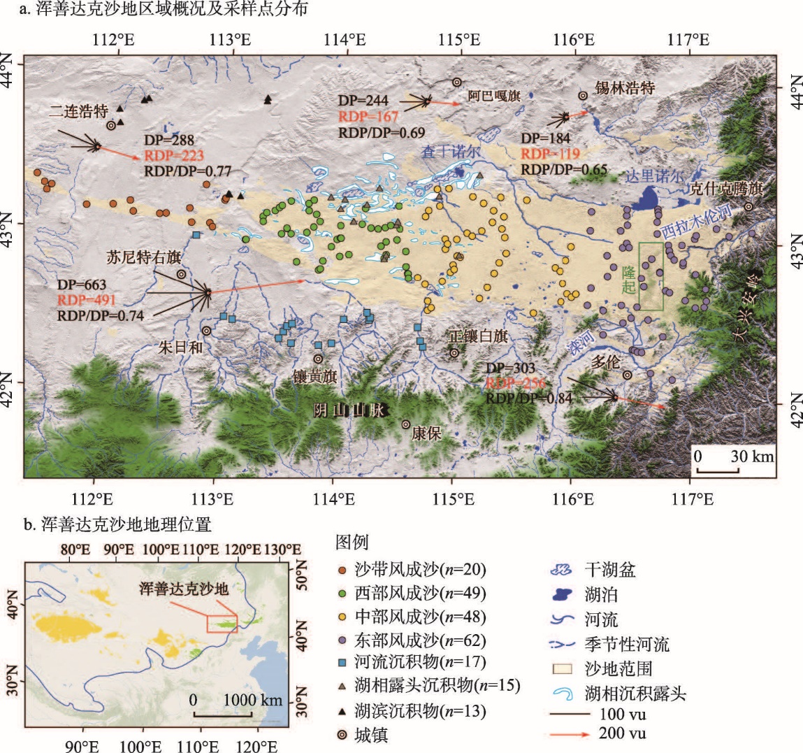
The grain size of sediments in sand seas is influenced by both sand provenance and various surface processes. This study collected 224 sedimentary samples from the Hunshandake Sandy Land including aeolian sand, fluvial and lacustrine sediments. Grain size measurement and end member analysis found that the mean grain size and sorting of aeolian sand generally decreased across the Hunshandake Sandy Land downwind in the SE direction. The spatial variations of skewness and kurtosis are more complex, indicating that the grain size parameters of aeolian sand are affected by the local provenance, depositional environment, and vegetation coverage. The end member analysis shows that the aeolian sand contains six end members (EM). EM1 is related to lacustrine outcrops in the western sandy land, while EM2 is likely to originate from loose fluvial and lacustrine sediments, controlled by both wind and topography. Fluvial deposits contribute to the widely distributed EM3, which is the dominant aeolian sand fraction found across the region. EM4 is predominantly found in the outer regions of the sand sea and closely associated with alluvial/fluvial deposits. EM5 and EM6 have the coarsest grain size and may originate from lacustrine/fluvial sediments that accumulated during past interglacials. Our findings suggest that the dune sand in Hunshandake mainly comes from the lacustrine/fluvial deposits around the sand sea, while the sand belt is unlikely to be a major source of dune sand. Aeolian sand with different sources is mixed in the western Hunshandake with fine fractions moved by the prevailing wind to the central and eastern parts of the sand sea. Rivers originating from the southern and eastern mountains also contribute aeolian sand to the adjacent areas. This study highlights the importance of extensive sampling combined with end member modeling for discriminating aeolian sand sources in desert areas.
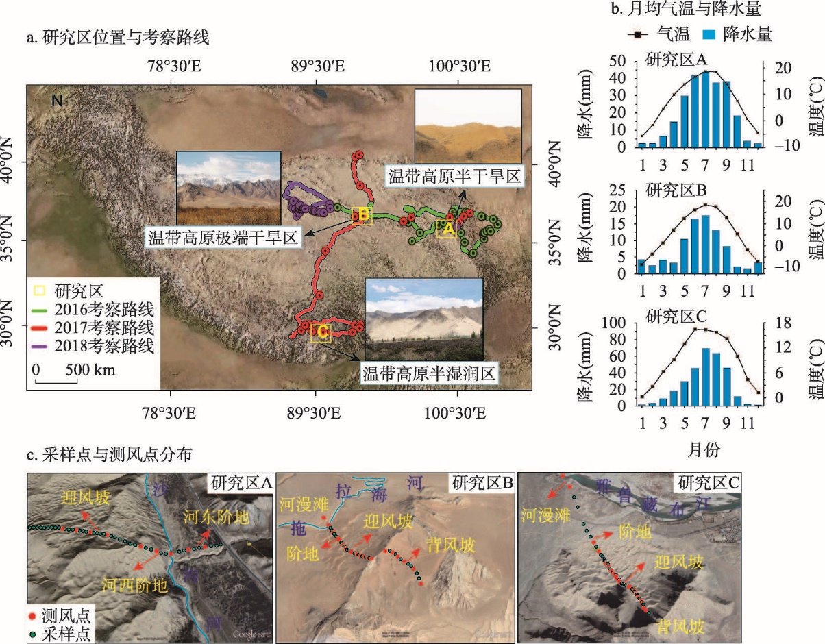
Climbing dunes are important barrier dunes that are widely distributed in highland mountain regions, and their formation is mainly controlled by topography, sand sources and wind regime. Existing researches mainly focus on simulation experiments, distribution patterns, field observations, and morphological characteristics. From a regional scale, there is a lack of research to analyze the variations in sediment characteristics and environmental significance of climbing dunes in different climatic regions. In this study, the wind regime, near-surface airflow, sediment characteristics and material sources of climbing dunes on the Qinghai-Tibet Plateau were comprehensively analyzed from the aspects of aeolian geomorphology, grain-size sedimentology, and geochemistry. The results show that: (1) Due to differences in material sources, the grain-size composition of climbing dunes sediments in different climatic areas varies, primarily fine and medium sands, with good sorting in the semi-humid areas and poor sorting in arid areas. The grain-size difference of sediments in different geomorphic parts is small, and it responds well to near-surface airflow, and in-situ sand accumulation is the basic formation form, with fine sand having the strongest climbing ability. (2) The chemical element content of sediments is influenced by the parent rock characteristics and the climatic environment, and the particle size is also important to its spatial variation, and trace elements are primarily concentrated in river floodplains, with little variation between geomorphic sites. (3) Except for SiO2 enrichment, all macronutrients in the sediment show varying degrees of leaching or enrichment, and the majority of trace elements are deficient, as leaching and enrichment are closely related to particle size. (4) Climbing dunes sediments are in the early stage of continental weathering, with higher weathering levels in the semi-humid zone. The weathering of sediments in different geomorphic sites varies substantially, which is related to the parent rock, climatic environment, and grain size.