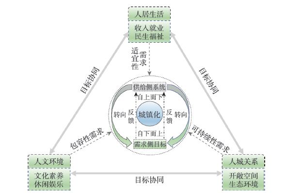
As China's urbanization has entered the middle and later stage and the improvement of well-being of residents has become a core goal, the transformation from "top-down" system goals optimization on the supply side to "bottom-up" multi-dimensional goals coordination on the demand side has become a new perspective to understand the connotation of urbanization. Based on the perspective of the human living conditions, the humanities environment, and human-city relationship, this paper constructs a connotation framework and index system of urbanization. Furthermore, Theil index is employed to analyze the spatio-temporal differentiation characteristics of China's urbanization before and after the implementation of the new-type urbanization strategy. Finally, in terms of both direct and indirect effect mechanisms, the mechanism framework of urbanization differentiation is constructed, and its evolution pattern is revealed by using Variance Decomposition and Geodetector. The results show that: since the implementation of the new-type urbanization strategy in 2014, China's urbanization has made remarkable achievements, with a steady improvement in human living conditions and human-city relationship, and there is still much room for improvement in the humanities environment. The high-level areas of urbanization are mainly distributed in coastal areas, and expanding to inland areas along the Yangtze River Basin and Yellow River Basin. The regional differences of urbanization gradually decrease, but the contribution rate of inner-regional differences shows an expanding trend. Differences in human living conditions and human-city relationship are the main factors of urbanization differentiation, but the contribution of differences in humanities environment is gradually expanding after 2014. Opening up and scientific & technological innovation are the main influencing factors of the difference in human living conditions. With the implementation of the new-type urbanization strategy, the impact on differences in humanities environment of the government finance gradually diminishes. Resource endowments have a relatively strong influence on differences in human-city relationship. This study can provide theoretical and empirical support for promoting the development of urbanization in China.
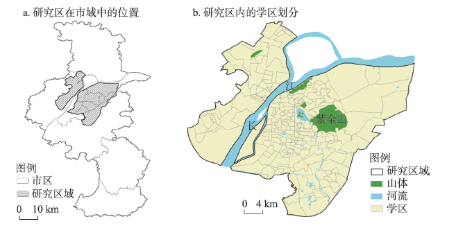
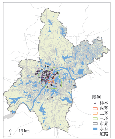
Jiaoyufication, as an education-driven gentrification in urban China, mainly refers to the social space process that the well-off middle-class groups who attach importance to education cluster around the catchment zone of leading elementary schools through the purchase of an apartment in the district at an inflated price. Based on the existing theoretical analysis of Jiaoyufication by domestic and foreign scholars, this empirical study is carried out by utilizing multi-source data such as POI, real estate market, portraits of mobile phone users and questionnaires in 2020, taking Nanjing as a case. This paper evaluates the Jiaoyufication level of 218 public primary school districts in the main urban area of Nanjing by virtue of the entropy-weight TOPSIS model. Findings show that only a few top-level school districts are highly gentrified, and they are contiguous and mainly settle in Gulou and Xuanwu districts. In order to better reveal the characteristics of typical gentrified school districts, they are divided into four types by Jiaoyufication level, namely high level Jiaoyufied school districts, mid-high level Jiaoyufied school districts, medium level Jiaoyufied school districts and low level Jiaoyufied school districts. Results demonstrate that there is a close correlation between the unit system and the highly Jiaoyufied neighborhoods that register the presence of a substantial number of middle-class families with high social, economic and cultural capital and paying great attention to children's education. They attempt to buy their way into the catchment areas of prestigious schools regardless of lower quality of life, inhabit them for relatively brief periods, and then sell them on at a profit to the next cohort of parents without needing to invest to improve them. A combination of strict school district systems in policy, soaring market-oriented school district housing prices and surging educational anxiety in the cultural realm continuously strengthens the educational resource advantages of elite schools and intensifies Jiaoyufication, which nails down high-quality educational opportunities to specific neighborhoods and groups. Jiaoyufication is essentially a process in which "school district space", as the pivotal driving factor, promotes the mutual transformation and consolidation of economic capital and cultural capital, and passes the family's social capital on to the next generation. This kind of social space reconstruction caused by imbalance of high-quality educational resources can easily widen the gap between the rich and the poor and perpetuates the class stratification. To avoid the negative effects brought by Jiaoyufication and promote the equity of education and society, it is necessary to effectively advance the balanced development of resources in urban compulsory education and students.
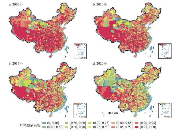
Eliminating inequality and achieving balanced development is one of the Sustainable Development Goals of the United Nations. Accurate measurement of development equilibrium is a primary scientific problem to be solved urgently. Nighttime lights data have been proven to be a good proxy for economic activity, and they have been used widely due to their advantages of convenient acquisition and wide spatial coverage. Therefore, in this study, we applied the Gini coefficients derived from nighttime lights data and pixelized population data to evaluate the development equilibria for China's 2900 counties from 2002-2020. We then examined the nexus of the development equilibrium and developmental vitality represented by the average nighttime lights intensity within each county. The results showed that the Gini coefficients based on nighttime lights data have generally been decreasing for 96% of the counties in China during 2002-2020. Moreover, in general, the Gini coefficients present a spatial pattern of being lower in the east and higher in the west. The results illustrate the synergetic development pathways of economic growth and equilibrium promotion of the economically developed counties, although the variation of their equilibria is significant. On the contrary, there is still distinct room for improvement of development equilibria for 60% of the economically underdeveloped counties in China. The results provide scientific support for achieving balanced development and promoting common prosperity in China.
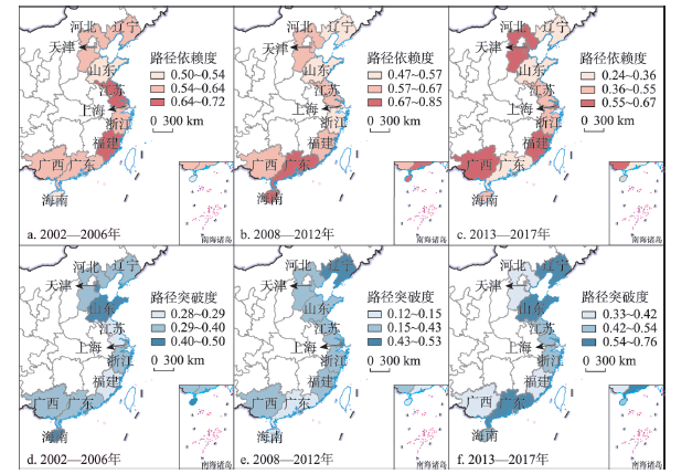
Regional industrial evolution path dependence and path creation are the key to investigate regional economic resilience from the perspective of evolutionary economic geography. Exploring the impact of industrial evolutionary path dependence and path creation on regional economic resilience based on regional new industries from an empirical perspective can improve the understanding of industrial evolutionary path and regional economic resilience. Taking the coastal areas of China as an example, we measure and analyze its spatio-temporal distribution characteristics based on a panel data from 2002 to 2017. This paper explores the main affecting factors of regional economic resilience in China's coastal areas by using one-step system GMM. Results show that: (1) The gaps in regional economic resilience in China's coastal areas has narrowed in the early financial crisis, but then presented obvious differentiation. Shanghai and Guangdong showed a U-shaped distribution; Fujian, Guangxi and Hainan continued to improve and maintain a high level; Jiangsu and Zhejiang saw two declines and then recovered quickly during the financial crisis and the early stage of the new normal; the Bohai Rim is mostly negative. (2) The path dependency in China's coastal areas is generally higher than path creativity. The overall industrial evolution path dependency and path creativity showed a fluctuating trend of decline and rise respectively, and path creation gradually became the main direction of industrial evolution. (3) The number of new industries in each region decreased significantly under the impact of the financial crisis. The advantages of new industries in steel and its products declined rapidly, and then concentrated in chemical industry, machinery manufacturing and other industries. (4) Dialectically looking at different evolutionary paths is of great significance to regional resilience. Both path dependence and path creation of industrial evolution have a positive influence on regional economic resilience, and the influence of path creation is more prominent. In addition, economic development level, per fixed assets investment and ratio of fixed asset investment to GDP affect economic resilience at the same time.
Exploring the influence and mechanism of the change of location advantage in manufacturing on the labor spatial mobility is of great significance to optimize the spatial distribution of China's manufacturing and improve the efficiency of labor spatial allocation. Based on the data of China Industry Database and China Migrants Dynamics Survey, using the improved Shift-Share Analysis method to measure the change of location advantage, this paper reveals the changing pattern of manufacturing location advantage and the characteristics of labor spatial mobility in China, empirically analyzing the influence and mechanism of the change of location advantage in manufacturing on the labor spatial mobility by conditional logit model. The results are shown as follows: (1) On the whole, during the research period, the rise of the location advantage in manufacturing is conducive to attract the inflow of labor in this field. (2) The positive effect of employment and income brought by the rising location advantage in manufacturing promotes the labor inflow, while the negative effect of ecological environment suppresses the labor inflow. (3) There are obvious differences among industries with different technological complexities and factor intensities, cities with different geographical locations, economic locations and scales, and labor forces with different individual characteristics. The rise of the advantage location in technology-intensive and capital-intensive industries can attract labor inflow obviously, while labor-intensive and resource-intensive industries cannot. Under the background of the rising location advantage in manufacturing, cities located in central and western regions can attract labor inflow obviously, while cities located in eastern and northeast regions cannot; peripheral cities of the urban agglomeration can attract labor inflow obviously, while central cities and other cities cannot; large and medium-sized cities are conducive to attracting labor inflow, while super-large and small cities cannot. In contrast, the labor with older age, lower education, intra-province flow and agricultural hukou is more likely to choose the cities when the location advantage in manufacturing increases.
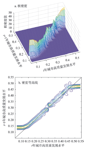
The high-quality development of national strategic regions is a hot topic in today's academic circles. Central China connects the east to the west and links the south to the north, which plays a pivotal role in supporting the coordinated development in China. At present, there is a relative lack of multi-scale and multi-dimensional comprehensive analysis on high-quality development in Central China. Based on the basic logic and scientific connotation of high-quality development in Central China, this paper constructs an evaluation index system to measure the high-quality development level of Central China from 2006 to 2019, and examines the spatiotemporal pattern of high-quality development in Central China from a multi-level spatial scale, and uses the traditional and spatial kernel density to analyze the distribution dynamic evolution and long-term transfer trend, and explores its formation mechanism from a structural perspective. The results show that: (1) The high-quality development level in Central China is lower than the national average, but the growth rate is relatively large; the gap is obvious between the eastern and central regions, and it is close to the western and northeastern regions; Central China presents a distribution pattern of "provincial capital cities are better than non-provincial capital cities". (2) The high-quality development in Central China is generally good, but there is a trend of spatial polarization, among which, Henan and Hubei are prominent. The high-quality development in Central China generally has the characteristics of "club convergence"; the positive spillover effect of the high-level neighboring cities in the whole region and most provinces is significant, while the spatial spillover effect of Hubei and Shanxi is not obvious. (3) From the perspective of structure, the differences between the central and other regions are mainly due to differences in economic structure, ecological environment and people's livelihood development, and internal differences come from differences in coordination and innovation; structural optimization and people's livelihood development are the main driving forces for high-quality development in Central China, and the formation mechanism of polarization characteristics varies from province to province. Among them, the polarization trend of Henan and Hubei is mainly determined by the characteristics of structural coordination and technological innovation; the spillover of industrial elements, ecological cooperation and development, and people's livelihood co-construction and sharing are the main reasons for the transfer of high-quality development in the region, but there is obvious spatial heterogeneity in the formation mechanism of transfer across provinces.
The integration of evolutionary economic geography (EEG) and relational economic geography (REG) is a main trend of international economic geography development. Based on the combination of EEG and REG theory, this paper proposed an analytical framework including strategic coupling, windows of locational opportunity and industrial transfer, and explained it from a particular perspective with respect to the key problem in economic geography of how to analyze the relocation of strategic partner of leading firms (SPLFs) in global production networks (GPNs) drawing on the case of Foxconn, an important strategic partner of Apple Inc., which acts as a leading firm in GPNs typically. The findings can be summarized as follows: (1) The occurrence of strategic coupling, decoupling and recoupling depends on the dynamic evolution of the matching degree between strategic demand of SPLFs in GPNs and regional assets. (2) The decoupling caused by the mismatch between strategic demands of SPLFs in GPNs and regional assets opened the windows of locational opportunity for the industrial transfer. (3) The matching degree gap between the strategic demands of SPLFs in GPNs and regional assets is the core factor for SPLFs in GPNs to choose the transferee. While ubiquitous general regional assets matter little, the specific regional assets play a key role in the process. With the formation of recoupling in the transferee, the windows of locational opportunity for the industrial transfer has been closed. (4) The institutional arrangements and development strategy of the transferer and transferee have an important impact on the state of strategic coupling and the change of windows of locational opportunity, which is the key to understand the Foxconn's relocation. (5) As one of the SPLFs in GPNs, Foxconn's relocation has been deeply affected by the Apple Inc., which is also the biggest difference between Foxconn's relocation and an ordinary industrial transfer. This study deepened the understanding of strategic coupling theory, extended the strategic coupling theory and windows of locational opportunity theory to the research of enterprises' relocation, and provided a new perspective for understanding the mechanism of industrial transfer.

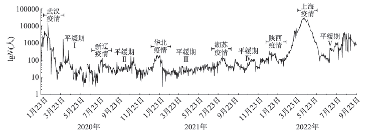
Since 2020, the COVID-19 epidemic has repeatedly resurfaced in several cities in China, causing significant shocks to residents' lives and consumption. Accurately measuring the impact of the epidemic shock on household consumption and its structure is an important issue in the economic assessment of the epidemic and in promoting the recovery of household consumption. Based on the monthly data of household consumption from January 2020 to September 2022, this paper conducted a quantitative assessment study of the impact of the COVID-19 epidemic on household consumption structure based on the tourism background trend line theory, the monthly index decomposition model and the background line distance level analysis method. The results found that: (1) The COVID-19 epidemic had a direct impact on all eight types of consumption, with smaller losses in food, clothing and housing, and larger losses in transport, culture and entertainment, and healthcare, etc. The recovery period for the rigid demand was significantly faster than that for optional consumption; the six waves of the epidemic caused different curves of fluctuations in the high-resolution distance levels of the eight types of consumption. (2) Comparing the changes in consumption structure in the three years before and after the epidemic, we found that: the Engel's coefficient of consumption rebounded by 2 percentage points. The mental Engel's coefficient dropped by 2.6 percentage points. The structural diversification index dropped by 3.4 percentage points. This means that an obvious downgrading happened in the structure of short-term consumption. Comparing the structural changes in consumption in the period of the epidemic shock with those in the period of the epidemic slowdown, a similar fluctuation cycle was observed. (3) In terms of the impact of the six waves of the epidemic, the Wuhan epidemic in 2020 and the Shanghai epidemic in 2022 had a greater impact, resulting in losses of up to 1092 yuan per capita and 490 yuan per capita for all types of consumption by residents. Finally, combining the variation of CPI and the epidemic prevention policies, this paper conducts a cause analysis of food consumption growth and the continued negative margin of healthcare consumption.
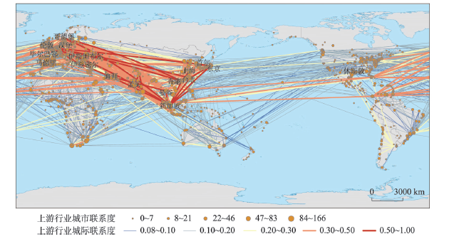
The shipping service industry is a major driving force in the economic growth and reorganization of port cities' spatial structure, as well as a core element in raising hub port cities' competitiveness. Recently, the global distribution and network connections of the shipping service industry have attracted significant attention, but few studies have analyzed the distribution differences and influencing factors of different shipping service industries. In this study, we divided the shipping service industry into upstream shipping auxiliary industries (ship owners, ship management, ship repair and construction) and downstream shipping derivative service industries (shipping finance, shipping insurance, maritime law). And based on Lloyd's Maritime Directory in 2019, we built a database about the world's shipping service industry. The spatial connection network of the global shipping service industry was then examined at the global, regional and city levels, using the correlation network model and the negative binomial regression model, which revealed the differences in distribution between the upstream and downstream shipping services. The affecting elements on upstream and downstream shipping services are explored in the last section. The results are as follows: (1) Europe and Asia are the primary distribution region of the upstream and downstream shipping service industries, a pyramid structure is shown under the variation in countries' distribution. The spatial distribution of the upstream industry is wider in range, closer in connections and stronger in agglomeration, compared to the downstream industry. (2) The global shipping service network presents a dual-center structure. Europe centers on London and builds a trans-continental radiation network of downstream shipping derivative services connecting to neighboring capital cities. Asia forms an upstream service network that connects Hong Kong, Shanghai and other cities with Singapore as the center. (3) The upstream shipping auxiliary industry is mainly distributed in non-capital seaport cities, while the downstream shipping derivative service industry is chiefly distributed in the capitals and other administrative centers. (4) The e-commerce index and the logistics performance index are positively related to the upstream and downstream industries. Otherwise, the upstream shipping auxiliary industry is also affected by the degree of economic freedom, the number of tourist arrivals, and the liner transport index, while the downstream shipping derivative service industry is mainly influenced by international trade and political culture. This study provides a theoretical reference for China to construct an international shipping center, reaches the linkage development between upstream and downstream shipping services, and improves the overall strength of China's shipping industry.
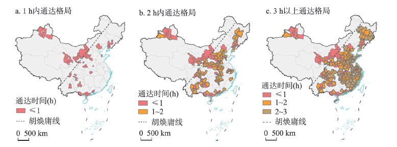
A well-developed transportation network can profoundly influence the spatial connection of cities and reshape the regional spatial pattern. This paper used 2021 high-speed railway passenger time data, and took the construction of "National 123 Travel Traffic Circle" proposed in the "Outline for the Construction of a Strong Transportation Country" as the starting point. It compares and analyzes the access patterns and differences of national urban agglomerations and central cities, and further uses the SLPA model to identify the community division and overlapping space of all high-speed railway connected cities in China, and explores regional development trend and the geographic characteristics of overlapping space. Some conclusions can be drawn as follows: (1) There were 15 urban agglomerations with 2-hour access to Chinese urban agglomerations, accounting for 79% of the total number of urban agglomerations, and the weighted average access time of cities showed a "circle-type" spatial pattern of expanding from the central area to the peripheral areas from low to high. (2) Most of the 3-hour access contour coverage areas of central cities are beyond urban agglomerations, showing the spatial characteristics of "cross-urban agglomerations". (3) The overlapping community discovery algorithm divides China's urban space into 14 communities, and there are only 3 communities west of the Hu Line. (4) The overlapping space was identified for the divided communities, in which 9 communities overlapping a total of 27 cities were generated. (5) In terms of spatial morphology, the overlapping cities were distributed in a point or belt pattern; in terms of spatial location, the overlapping cities are mostly located around the regional central city, and in terms of administrative divisions, they were mostly in the inter-provincial junction zone; in terms of urban function, the overlapping cities rely on the high-speed railway circulation channel, and through the transition and conversion function, they were manifested as a network connection bridge between communities. From the perspective of high-speed railway transportation, the regional spatial pattern showed cross-urban agglomeration linkage and group development, and the networked, interactive, and cross-scale role of overlapping spaces was highlighted. For the better development of the city and the region, for the characteristics of overlapping communities and overlapping spaces, communities can try to fill in the gaps and improve the inter-community capacity, while overlapping spaces can try to combine their own advantages to create more cross-regional connection possibilities.
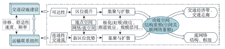
There are differences between high-speed rail and conventional rail in technical and economic characteristics such as speed, ticket price and reasonable transport distance. Therefore, they can reflect spatial traffic links at different scales, which have important impact on the reshaping of territorial space. Using train timetable data, this paper analyzes the differential spatial cascading system order of high-speed rail and conventional rail service, and compares the regional integration effect of these two rail modes on the spatial cascading system. The results show that, compared with conventional rail, the spatial layout of high-speed rail is more consistent with the gradient pattern of national economic and social development. The distance decay effect of traffic flows by high-speed rail is more obvious, with an advantage over conventional rail for journeys within 600 km. The advantaged cities of high-speed rail and conventional rail are spatially concentrated to the south and north of the Yangtze River respectively. The conventional rail service presents a more balanced distribution considering the demand of passenger transport. Further analysis shows that, under the influence of technical and economic advantages, competition between high-speed rail and conventional rail, and the network spatial layout, the regional integration effect of high-speed rail on efficiency space shows a significant polarization, with the neighboring regional agglomeration as the main form, while conventional rail has formed cross-regional corridor agglomeration along the north-south direction and east-west direction at the macro level. The regional integration model of high-speed rail and conventional rail also presents the characteristics of multi-center grading and multi-plate equalization respectively.
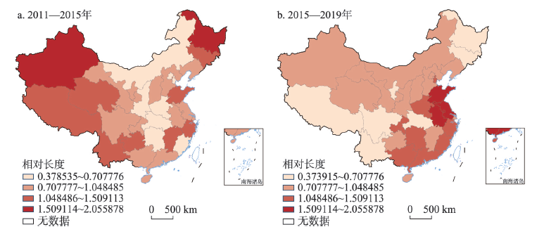
Against the background of the industrial transformation and upgrading, the coupling coordination concerning the scale, structure, and efficiency of the tourism industry is conducive to rationally optimizing its productivity, quality, and efficiency. There is great theoretical and practical significance in understanding the evolution characteristics and its factors influencing the high-quality development of the regional tourism industry. This study constructed an analysis framework regarding the coupling coordination relationship among scale, structure, and efficiency. The spatiotemporal dynamics characteristics and factors influencing the coupling coordination of scale, structure, and efficiency in China's tourism industry were studied from 2011 to 2019. The methods used to achieve this included the modified coupling coordination model, the Local Indicators of Spatial Auto-correlation (LISA) time path, spatiotemporal transition, and spatiotemporal weighted regression. The results show that: (1) The level of coupling coordination of the scale, structure, and efficiency of tourism industry in China showed a significant increasing trend, with the ranking of the regions in terms of this level being Easter Area> Central Area> Northeastern Area > Western Area. Moreover, a trend of a gradual increase in spatial diffusion was also evident. (2) There was an overall small range of fluctuation of local spatial structure and spatial dependence within the level of coupling coordination of scale, structure, and efficiency of tourism industry in China, whereas there was strong spatial integration. In addition, the structure of local spatial correlation was relatively stable and there were obvious transfer inertia and path dependence, particularly in the Northeastern and Western Areas. (3) Scientific and technological innovation, urbanization, and transportation facilities have all had significant positive impacts on the level of coupling coordination of the scale, structure, and efficiency of tourism industry in China. Furthermore, government regulation and industrial structure will play an increasingly important role in promoting the Central and Western Areas, while human capital will have a strong positive impact on the Eastern Area.
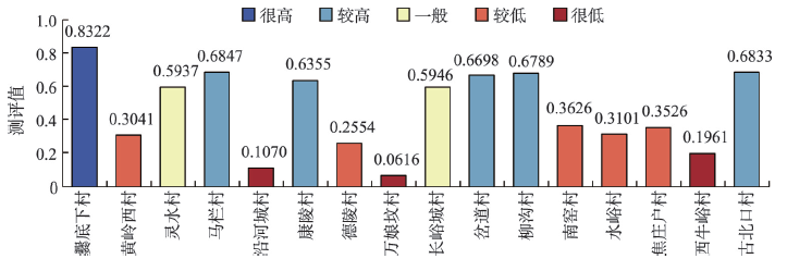
The integration of culture and tourism is conductive to the realization of the urban-rural integration and rural revitalization. Taking 16 typical traditional villages in Beijing as cases, this study proposes the evaluation system and influencing factor model of the integration of culture and tourism of traditional villages. Based on the TOPSIS model supported by entropy method, it analyzes the level of the integration of culture and tourism of traditional villages. Moreover, we discuss the main influencing factors and their paths of the integration of culture and tourism of traditional villages by using fuzzy-set qualitative comparative analysis (fs/QCA). The results can be concluded as follows: (1) The integration of culture and tourism of traditional villages is a dynamic process that continues to promote the comprehensive revitalization by deepening resource integration, advancing product cultivation and strengthening industry functions. (2) There are obvious differences in the development level of the integration of culture and tourism of case villages. Specifically, the level of each village in the four dimensions presents the characteristic of differentiation and imbalance. (3) None of single factors can constitute the necessary and sufficient conditions of the integration development of culture and tourism. (4) There are three influencing paths of the integration of culture and tourism of traditional villages, namely, mature development path, rapid development path and progressive development path, which correspond to their respective combinations of influencing factors. This study could provide theoretical inspiration and scientific guidance for the urban-rural integration and rural revitalization of traditional villages from the perspective of the integration of culture and tourism.
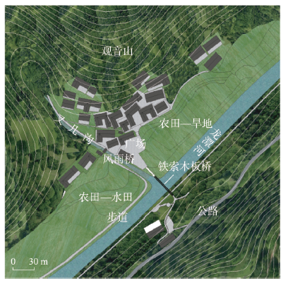
As the material carrier of native land, architectural heritage not only presents productive, living and ecological values in history, but also reflects changes of local people in mentality order and reproduces the character of symbolic communication of things due to its modernity practice, which reshapes material values and identities with the evolution of practice field. Diaojiaolou-the traditional stilted buildings, as a site of daily life practices for Chinese ethnic minorities, are mainly located in the Wuling mountain area, which contain local meanings on multiple levels, including material, institutional and spiritual significance. This paper constructed a dialectical framework of "time-space-place" from the perspective of "things", to dynamically investigate the interaction between homeland heritage and cultural subjects as well as the transformation of social order in the Wuling mountain area: (1) the presence of "things" represents the historical response to folk preservation and generation inheritance, carrying home culture and local memory; (2) The declining and disembedding of "things" implies the game and integration of macro power and individual behavior under the penetration of modernity, as well as the deconstruction, negotiation and reconstruction of local subjectivity; (3) The appearance of "things" suggests that the home is placed in a regional cultural value system at a deeper level, which shows up the spatial value of ethnic architecture, thus participating in the tourism context as a form of cultural capital. Furthermore, the paper tried to explore the reconstruction of the order of material, social and human ecological spaces of homeland heritage from a local perspective: (1) Spatial empowerment: landscape genes renew space value in the aspect of production; (2) Order reconstruction: social motivation activates space value in the aspect of life; (3) Local knowledge: multiple subjects nurture space value in the ecological aspect. Through the localization of "things", this study explores how "things", which have been hidden in the folk, attract multiple subjects to create a "field of memory" along with the modernization of ethnic areas, in order to achieve the order transformation from the daily "home" to the "place", thus exploring new paths for the survival of homeland heritage and the creation of "poetic dwelling"in China's ethnic areas, as well as promoting rural revitalization.
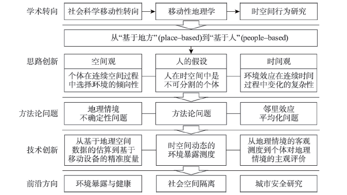
Against the backdrop of increasing mobility in human society, the approach of geographies of mobility have profoundly influenced various branches of the geography discipline. In this article, we review how geographies of mobility have developed traditional space-time behaviour studies. First, by shifting from a place-based to a people-based perspective, geographies of mobility seek to understand the interaction between indivisible individuals and continuous space-time, thereby addressing the uncertain geographic context problem and neighbourhood effect averaging problem. Second, new methods have been developed for capturing individuals' complex mobilities and dynamic environmental exposures. These range from estimation based on geographical data to real-time measures based on mobile devices as well as subjective measures of environmental exposure and people's perception of geographical contexts. Third, empirically, the geographies of mobility have made methodological contributions to three space-time behaviour research agendas, namely, health geography, social segregation, and urban safety. In short, rising mobility in contemporary urban China poses challenges to traditional methodologies in space-time behaviour studies while also providing opportunities for methodological innovation in this research field. The school of Chinese behavioral geography should keep pace with research on mobility and should keep the geographies of mobility in mind when advancing methodologies and empirical studies.
The COVID-19 patients have exceeded 6% of the world's population. How the COVID-19 infection experience affects the daily life of discharged patients has become a great concern in China and around the world. Focusing on the COVID-19 outbreak period in Wuhan, this study investigated the spatio-temporal behaviors of daily life of COVID-19 patients before infection and after discharge by means of paper questionnaires and telephone interviews. It was found that 6 months after discharge, the daily life of patients was characterized by longer sleep time throughout the day, mingled activities in daytime and more active leisure in evening leisure time. The main spatio-temporal behaviors of patients before and after the infection changed from going out for work to going out for work, from going out for work to mixed leisure, personal affairs and housework at home, and from leisure at home to mixed leisure, personal affairs and housework at home. Based on time geography theory, it was concluded that the changes of patients' spatio-temporal behaviors after discharge were caused by the capability constraints related to patients' physical and economic conditions, the coupling constraints of their life styles and required resources, and the authority constraints from policy regulations and public opinions. Further exploration of pathogenesis, good rehabilitation plan, and improvement of social recognition are essential to the physical and mental recovery of patients. These findings can provide scientific evidence for life quality evaluation of patients under major public health emergencies and public health policy formulation, and provide reference for enriching behavioral geography in spatio-temporal behavior research for special events, special groups and special periods.
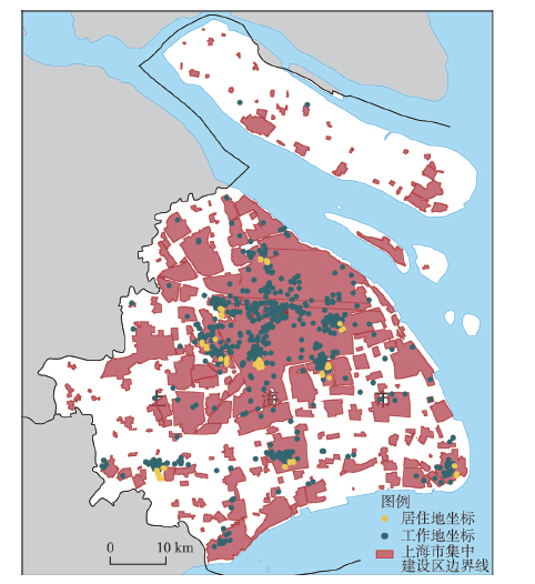
The alleviating effect of urban green space on anxiety has attracted the attention of scholars from multiple disciplines such as urban geography, urban planning and landscape ecology. However, whether plant color, as an important feature of green space, plays a key role in alleviating anxiety has not been examined thus far due to the limitation of the accuracy of data collection technology. Accordingly, this research attempts to innovatively construct a system to describe the colors of plant so as to explore the relationship between plant color and residents' anxiety under different geographical backgrounds. Through the combination of public citizen science and artificial intelligence, we constructed a high-precision urban forestry database and subsequently evaluated plant color in two levels from the perspective of visual perception, and compared the difference of plant colors in residential areas and workplaces. Ordinal logistic regression models were established to explore the relationship between plant color and anxiety. Research shows that plant color diversity can effectively relieve anxiety, but it was influenced by modifiable areal unit problem (MAUP) and uncertain geographic context problem (UGCoP). Specifically, improving the base color level of the living environment and increasing the diversity of plant colors in the workplace can help alleviate anxiety, and the correlation between plant color and anxiety is mainly observed in small-scale buffer zones. The above results confirm the correlation between plant color and anxiety, and can provide specific optimization suggestions for urban green space design.