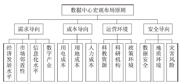
Data center is a new infrastructure system based on new development concepts, technological innovation, and information networks. It provides services for digital transformation, smart upgrading, and integrated innovation to meet the needs of high-quality development. The new infrastructure covers the construction of 5G base stations, intercity high-speed rail, intercity rail transit, new energy vehicle charging piles, big data centers, artificial intelligence, and industrial internet. It could promote resource integration, nurture new growth points, and shape new locations. Analyzing the spatial patterns of new infrastructures and their influencing factors is of great significance for understanding the regional development advantages. Using the data center as an example, this paper explores the spatial distribution and determinants of new infrastructure. Since the data center is not only infrastructure but also a strategic emerging industry, it is different from traditional infrastructure in terms of technical requirements and energy consumption. Since this difference will be reflected in the spatial layout, this paper proposes the macro layout principle of the data center. Then, the evolution characteristics and influencing factors of the spatial pattern of data centers in China are analyzed, and the following conclusions are drawn: (1) The macroscopic distribution of data centers should follow four principles: demand-oriented, cost oriented, operating environment-oriented, and safety oriented. (2) The distribution of data centers presents a spatial structure centered on the Beijing-Tianjin-Hebei region, Yangtze River Delta, Pearl River Delta, and Chengdu-Chongqing urban agglomeration. (3) Economic development, internet development, the number of high-tech enterprises, labor costs, and educational institutions have a positive impact on the macro layout of data centers. The impacts of location conditions, land costs, and layout policies of data centers on their macro layout begin to appear at a certain stage. (4) There are three types of data center distribution models in China: demand-orientated, cost-oriented, and demand-cost-operating environment-oriented. At present, the data center in China is demand-oriented and will develop into a comprehensive demand-cost-operating environment-oriented model in the future. Our conclusion could provide guidance and suggestions for scientific site selection and the optimal layout of data centers.
Technological knowledge polycentricity is a measure of the degree of polycentricity present in knowledge innovation; it can be used to model the spatial structure of technological knowledge production and cooperation within urban agglomerations, and can thus be used to gauge the level of innovation and the quality of development in an urban agglomeration. Drawing on patent application and inter-city patent cooperation data for 293 cities in China in the years 2000, 2005, 2010, 2015, and 2019, we used polycentricity measures, instrumental variables, and panel threshold models in order to explore the spatiotemporal evolution characteristics, type evolution trends, and innovation output effects of technological knowledge polycentricity in 19 urban agglomerations. Our results show that: (1) The evolution of the morphological and functional polycentricity of technological knowledge differs significantly between agglomerations—whilst morphological polycentricity showed a fluctuating trend (whereby a decline was followed by an increase and then a further decrease); in fact, we found functional polycentricity to have gradually increased over the study period. (2) Urban agglomerations with high morphological and functional polycentricity values were found to maintain higher innovation levels, while low morphological and functional polycentricity could be linked to lower innovation levels; the results of the type of distribution analysis, further, show that while morphological polycentricity did not present any obvious concentration or evolution trends over the study period, functional polycentricity increased significantly. (3) The modeling results show that the relation between the morphological polycentricity of urban agglomerations and urban innovation outputs has an inverted U-shaped relationship, with an inflection point at the value 0.438; functional polycentricity, in contrast, was found to maintain a consistently positive relationship with innovation outputs, confirming the importance of inter-city innovation cooperation when it comes to urban innovation output. Our conclusions on the development pattern of technological knowledge polycentricity can provide theoretical support for the formulation of innovation development strategies in urban agglomerations.
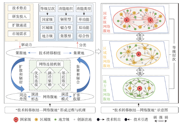
Technology transfer is an important way to enhance regional knowledge diversity and foster technological innovation hubs. However, there are relatively few studies on the spatial evolution complexity and evolution law of technology transfer hubs. Therefore, this paper develops a theoretical framework of technology transfer hubs based on WENA and Ht-index, empirically revealing the spatio-temporal dynamics of technology transfer hubs and their hinterworlds in China from 2004 to 2018. The results are obtained as follows: (1) Technology transfer hubs have the triple characteristics of hierarchy, spatial polarization, functional balance and complementarity. They are high-level technology transfer nodes with the function of agglomeration and diffusion in the national innovation system, mainly located in coastal cities such as Beijing, Shanghai, Shenzhen and Guangzhou. (2) The hierarchical system has a stable "pyramid" structure, showing a dual pattern of constancy and mutability, and their evolution has significant place dependence and spatial stickiness. In addition, hubs of technology transfer out and in exhibit bipolar and multi-center dominant spatial patterns, respectively. (3) Technology transfer hubs with dual functions of diffusion and agglomeration are the predominant type, electrical, chemical and mechanical engineering are the most dominant categories, and shows the evolution mode from dual-sector to multi-sector dominance. Overall, the evolution of technology transfer hubs is divided into three stages: functional separation in the initial stage, functional integration in the development stage, and functional synergy in the mature stage. (4) Hinterworlds of technology transfer hubs display the duality of significant expansion and competition, presenting a two-way expansion mechanism of core-periphery, forming three differentiated hinterworlds evolution patterns of progressive expansion (from inside to outside), jumping expansion (alternating inside and outside) and progressive contraction (from outside to inside).
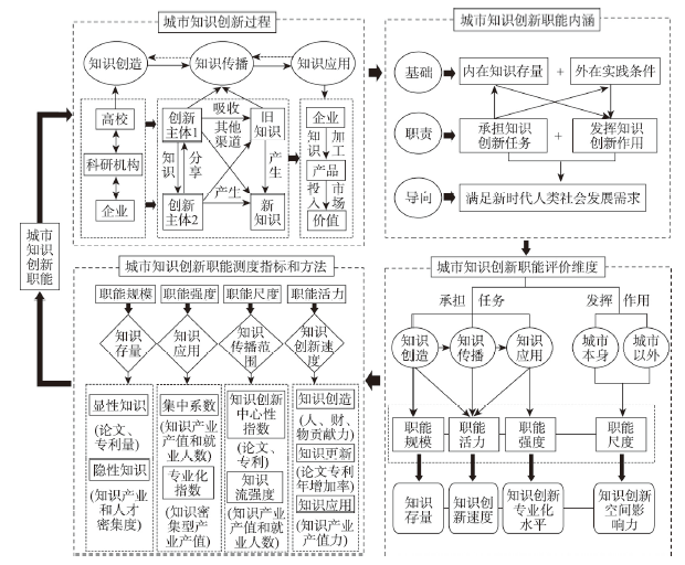
Knowledge innovation is an important part and development foundation of urban innovation functions. Combined with the multidisciplinary research content of knowledge innovation, this paper constructs a measurement framework for urban knowledge innovation function from the perspective of urban geography and analyzes its spatial pattern and influencing factors. The conclusions are as follows: (1) The urban knowledge innovation function is based on the internal knowledge stock and external practical conditions to meet the survival and development needs of the new era of mankind, the tasks and roles undertaken in the process of knowledge creation, knowledge dissemination and knowledge application, and the measurement dimensions include functional scale, functional strength, functional scope and functional vitality. (2) The level of development of knowledge innovation functions in Chinese cities is uneven, and the cities with outstanding knowledge innovation functions are mainly concentrated in the eastern coastal areas and a few developed areas in the central and western regions, forming a diamond-shaped knowledge innovation structure with Beijing-Tianjin, Yangtze River Delta, Pearl River Delta, Shaanxi-Chengdu-Chongqing, and Wuhan and Hefei in central China as vertices and centers, and divided into national, regional, regional and knowledge innovation development cities according to the natural breaks (Jenks). (3) In terms of influencing factors, the spatial differentiation characteristics of urban knowledge innovation functions are simultaneously affected by various factors of human environment and natural environment, among which the economic environment, the open environment and the cultural environment have the strongest interactive interpretation power on other factors, which is the leading factor affecting the development of urban knowledge innovation functions. In the future, China should take the initiative to enhance the knowledge innovation function of the city, fully consider the current situation and characteristics of the development of the city's own knowledge economy, formulate policies and measures suitable for the development of the city's knowledge economy, and strengthen the dominant position of human and social factors in the construction of urban knowledge innovation function.
The study of influencing mechanisms of intercity knowledge collaboration networks is an important research topic of innovative geography. Most existing research focuses on the influence of exogenous forces (e.g., urban resources endowment, multidimensional proximity), whereas less attention has been paid to endogenous factors (e.g., preferential attachment, transitivity). This research constructs an intercity knowledge collaboration network of Chinese cities based on the co-publication data from the Web of Science, analyzes its evolving characteristics of spatial and topological structures from 2006 to 2016, and quantitatively explores the endogenous and exogenous forces underlying the network formation through exponential random graph modelling. The results show that: (1) From the spatial structure perspective, the intercity knowledge flows are dense in the eastern region but spare in the western region, which is stable during 2006-2016. The overall network has developed from a dual-core structure of Beijing and Shanghai to a polycentric structure, in which five national-level urban agglomerations have become important bases for nurturing multiple centers. The nodal regions centered on highly administrative cities have become increasingly consistent with the planned urban agglomeration, which plays the dual role of proximal spillover and remote interaction of knowledge resources. (2) From the topological structure perspective, the scale and density of intercity knowledge flows have increased significantly, and the preferential attachment to big cities is obvious. However, with the rise of multiple centers, the network polarization and disassortativity have been weakened. With the optimization of intercity knowledge collaboration paths, the network cohesion has improved, thus becoming a small-world network. (3) From the influencing mechanism perspective, self-evolution and preferential attachment are important driving forces of knowledge collaboration networks, showing an overlapping effect with urban hierarchy. The positive impact of urban knowledge-related attributes on intercity flows is weaker than multidimensional proximity and path dependence. The presence of high-speed railways promotes knowledge collaboration, while the influence of geographic distance is not significant.
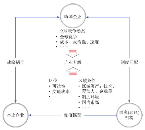
Industrial upgrading is one of the most concerned topics for latecomer economies, but existing research in this field has unpacked regional industrial upgrading from geographical aspects. This paper conducts a critical review on the research progress of industrial upgrading and points out that current studies tend to describe spatial changes rather than disclose geographical motivations of industrial upgrading. Thus, the geographical attributes, patterns and evolution paths of industrial upgrading are yet to be revealed. Based on the perspective of relational economic geography and to explore industrial upgrading patterns, this paper constructs an analytical framework from both the enterprise and the region levels, and find four upgrading patterns: enterprise upgrading, structural upgrading, regional upgrading, and involutional development. Following that, this paper reveals that there is a general evolution path of regional industrial upgrading under globalization. Regions have the tendency to evolve from enterprise upgrading or structural upgrading to regional upgrading and then to involutional development. This evolutionary path is well matched with the industrial upgrading trajectory of the Pearl River Delta. Also, industrial upgrading in the delta has shown a circuitous evolutionary path, which can be termed an "S-type paradigm". Overall, this research suggests that regional industrial upgrading is affected by external forces outside regions under globalization. The performances and achievement of regions can be analyzed from both the corporate and the regional levels. From the aspect of technology, capital and market, latecomer regions can use their geographic advantages to bargain with transnational corporations, in the process of which local institutions and territorial environment have a significant role to play. The major contribution of this paper comes from its new analytical perspective to understand the process of regional industrial upgrading and its finding about different performances of industrial upgrading in different scales, including the enterprises and the region scales. Also, an industrial upgrading pattern that is different from the well-known "the flying geese paradigm" has been proposed, which tentatively provides an innovative framework to understand development of latecomer economies under globalization and refine theories about globalization in economic geography.
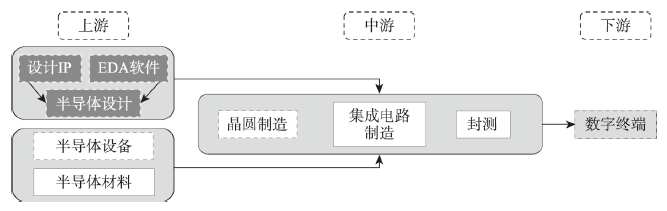
The semiconductor industry has the typical characteristics of an international division of labor and shows significant structural differences in global trade in the key product chain. The evolution of cross-border trade flows and dependencies, as well as trade organization patterns in semiconductor manufactured goods, key equipment, and materials, are investigated by constructing a global matrix of semiconductor trade relations and using the Gini Coefficient and Trade Dependency Index. The study found that: (1) The geography of global semiconductor trade is extremely unbalanced, trade-in materials and equipment are highly concentrated in a few countries on both the supply and demand sides. (2) China has replaced the US as the world's largest semiconductor trade player and, together with other Asian regions, has shaped the regionalized system in the trade of manufactured goods and materials, but there is a high dependence on Europe and the US for equipment. (3) The semiconductor production model has promoted the regionalization of the East Asia-Southeast Asia region in the trade of manufactured goods and materials, and developed countries such as the US, the EU and Japan, and South Korea have maintained their monopolistic advantage in the trade of semiconductor equipment by building exclusive innovation networks and establishing trade barriers. The monopolistic nature of the semiconductor equipment trade and the regionalization of manufactured goods and materials have formed the characteristics of the global semiconductor trade and will be further strengthened in the future.
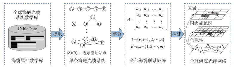
As a kind of large-scale connectivity infrastructure, submarine cables play a vital role in international telecommunication, socio-economic development, and national defense and security. However, the current understanding about the spatial pattern of global submarine optical cable network is relatively limited. In this article, we analyze the spatial distribution and connectivity pattern of global submarine cables, and identify their strategic pivots and strategic channels. The main conclusions are as follows: (1) The spatial distribution of global submarine cables is significantly unbalanced, which is characterized by the facts that the distribution of submarine cable lines is similar to that of sea lanes, and the agglomerations of landing stations are distributed unevenly along the coastline. (2) The connectivity pattern of global submarine cable network has a significant scale effect. At the micro, meso and macro scales, the connectivity structure presents chain model, cluster model and hub-and-spoke model, respectively. (3) The distribution of strategic pivots and strategic channels shows a pyramidal hierarchical feature. Singapore ranks highest among all the strategic pivots, while the Gulf of Aden and the Strait of Malacca rank highest among the strategic channels. Based on the identification of strategic pivots and channels, 6 strategic regions have been divided, which face various network security risks and need special attention and vigilance.
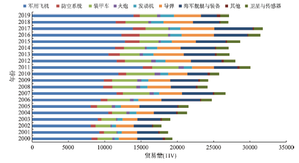
Changes in global military technological strength will reshape the world pattern and thus affect the trend of the international situation. Accurately grasping the evolution of the world's military technological pattern is of great practical significance for a profound understanding and effective response to the great changes unseen in a century. As arms are products that reflect military science and technology, this article uses SIPRI arms trade data and the World Bank database to investigate the evolution of the spatial and temporal patterns and driving mechanisms of global arms trade from three aspects: product structure, network pattern and influence mechanism, and finds that: (1) the scale of global arms trade shows a fluctuating upward trend, the structure of trade products is dominated by aircraft with other major products including naval ships and weapons, missiles and armored vehicles. Aircrafts are the main export products or import-dependent products of most countries. (2) The global arms export pattern is characterized by the tripolar distribution of the United States, Russia and Western Europe. The influence of Asian countries has increased significantly. The geo-military pattern has obvious characteristics of rising in the east and falling in the west, and rising in the south and falling in the north. Importing countries are concentrated in East Asia-Southeast Asia-South Asia-Middle East-Southern Europe-North Africa, and the spatial distribution pattern is consistent with Rimland theory of Nicholas John Spykma. (3) The global arms trade network is characterized by one superpower and multiple major powers. Eurasia has always been the main arena for global arms trade, and Asian countries have become an important force in reshaping the trade landscape. (4) The competition pattern of arms trade centered on the United States and Russia is highlighted. The flattening trend of the largest trade network in the United States reveals the improvement of the United States' leading ability and the decline of the sub-dominant countries in Western Europe. (5) The evolution of the global arms trade network is affected by the attributes and proximity of importing and exporting countries. History, language and economic proximity have positive effects on arms trade network, while geographical distance has negative effects on trade network. National development, level of science and technology, intensity of military spending, political stability, and resource endowment have varying degrees of influence on arms trade.
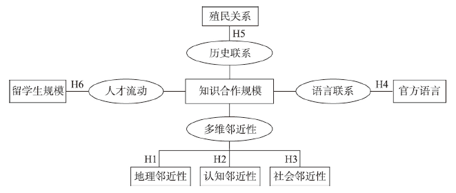
As the world enters a new era of big developments and changes, the inter-country and inter-region scientific collaboration has seen fundamental changes in its environment, which not only faces unprecedented opportunities but also encounters grand challenges. Consequently, exploring the network dynamics and driving mechanisms of global scientific collaboration plays a critical role in the judgment of global science competition and cooperation. This paper, from the perspective of "node-line-network" and based on the dynamic logic in proximity approaches, uses the internationally co-authored papers data from the InCites database of Clarivate Analytics company for the period 2000-2019, and investigates the position of countries/regions, bilateral partnerships between countries/regions, the evolution of network structure, and reveals dynamic mechanisms of international scientific collaboration network as well as how the influence of driving factors changes over time. Firstly, results show that the traditional science powerhouses, such as the United States, the United Kingdom, France, and Germany, have occupied central and critical positions in the network. At the same time, the emerging scientific nations have strengthened their centrality and influence in the network, including China, South Korea, India, and South Africa, which are gradually close to the core position. Secondly, the number of ties between countries has increased dramatically. The research partnership between Germany and the United States is gradually giving way to China-US collaboration, which becomes the most important bilateral collaboration between countries in the world. Thirdly, the global scientific collaboration network is characterized by a star-shaped structure. As globalization and networking of science advance, decentralization in the collaboration network grows increasingly refined. The whole network has evolved from a single group dominated by the United States to a double group including the United States and Saudi Arabia. Finally, the extended gravity model indicates that geographical proximity, social proximity, cognitive proximity, common language, historical links, and talent flows have a positive effect on international scientific collaboration. As the knowledge network evolves, the importance of geographical proximity, common language, and historical links has waned over time, while the significance of social proximity, cognitive proximity, and talent flows has increased.
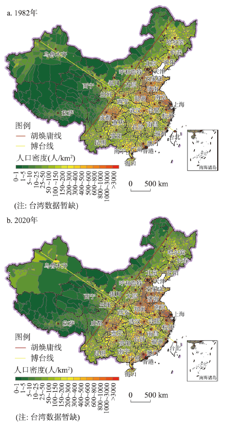
Under the background of promoting more balanced and fuller regional development in the new era, standing at the strategic height of national regional coordinated and balanced development, it is necessary to comprehensively consider the natural environment, the unbalanced situation of economic and social development and the reality of widening gap on both sides of the Hu Huanyong Line, and put forward the basic idea of the Hu Huanyong Line to achieve micro-breakthrough along the Bole-Taipei Line. The Hu Huanyong Line is an important dividing line of population geography, natural geography and ecological environment in China, the dividing line of national main function area and national ecological function area, the dividing line of new urbanization main area and non-main area in China, and the dividing line of unbalanced and inadequate economic and social development in China. In the past 40 years, the gap of economic and social development between the two sides of the Hu Huanyong Line has been widening at an accelerating speed. In the next 30 years, the gap can be narrowed to achieve micro-breakthroughs, focusing on achieving "ten 10%", namely, the proportion of population in the northwest half of China will be 10%, the proportion of total economy will be 10%, with the economic growth rate being more than 10%, the proportion of fixed asset investment in the whole society will be more than 10%, the proportion of local fiscal revenue will be more than 10%, the proportion of actual use of foreign capital will be 10%, the growth rate of per capita GDP will be more than 10%, the rate of increase in the absolute difference in the per capita disposable income of urban residents will be controlled within 10%, the rate of increase in the absolute difference in the per capita disposable income of rural residents will be controlled within 10%, and the absolute gap in education resources will be narrowing at an average annual rate of 10%. In order to achieve the strategic goal of micro-breakthrough, this paper puts forward the main paths and countermeasures to narrow the development gap between the east and the west of the Hu Huanyong Line and attain the micro-breakthrough from the aspects of population micro-layout, economic micro-layout, urbanization micro-layout, industrial micro-layout, moderate water diversion nearby, improvement of ecological compensation and transfer mechanism, construction of the Bole-Taipei Line and implementation of the strategy of further development in the western region.
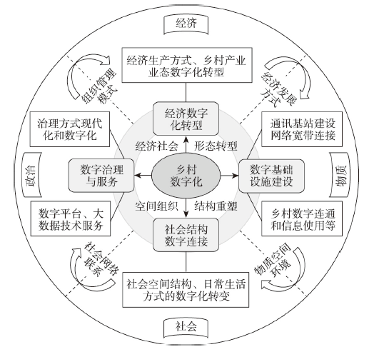
The extension and penetration of digital technology into rural areas profoundly affects the organization and structure of rural economy, society and politics, and promotes the transformation and reorganization of rural territorial system from the perspective of urban-rural development network. Based on defining the concept of rural digitalization, this paper discusses the coupling relationship between rural digitalization and rural spatial transformation, deeply analyzes the mechanism of rural digitalization and rural spatial transformation, and builds a research framework for rural digitalization development and transformation. The main conclusions are as follows: (1) Rural digitalization is a process of reshaping the physical environment, economic form, social network and spatial organization of rural areas with the wide application of digital technology in vast rural areas. It promotes the digital transformation of rural economic and social forms and spatial organizational structure, including the process, role and effect of digital technology on rural regional space. (2) Under the background of rural digitalization, the transformation of rural space tends to be comprehensive and complex, and multiple spaces such as material, economy, society and culture are superimposed and transformed, and cyberspace and network culture forms are derived under the connection of digital information. (3) The multi-dimensional embedded mechanism of rural digitalization and rural spatial transformation includes the logic of digital infrastructure construction and rural physical environment transformation, the mechanism of digital economic development and rural economic transformation, the relationship between digital technology application and rural social network restructuring, digital governance models and the role of rural spatial organization reconstruction. (4) Under the major strategic direction of urban-rural integrated development and rural revitalization, future research needs to explore frontier fields and innovative dimensions of rural development based on digitalization for strengthening disciplinary contributions. It includes focusing on smart rural application scenarios, developing rural planning and construction systems and engineering technical specifications, and serving the rural sustainable development, informatization and modernization of rural development.
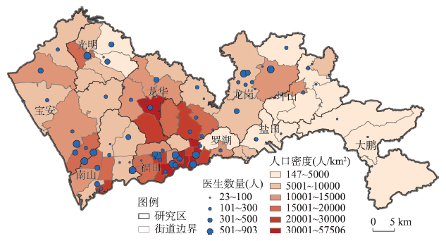
Rational configuration and spatial equity of urban medical facilities is an important topic in geography. The Maximal Accessibility Equality (MAE) model is an important progress in the field of spatial equity-oriented location-allocation models. However, existing studies have paid less attention to the spatial equity measures in MAE models. Aiming to fill this research gap, this study attempts to clarify the meaning of spatial equity of medical accessibility. Based on a review of existing studies, 10 spatial equity measures are selected for investigation in this study. The MAE mode is extended by incorporating these measures. Using medical facilities in Shenzhen as a case study, these improved models are applied, evaluated and compared. The following findings are drawn: (1) From the perspective of theoretical foundation behind the measures, the Coefficient of Variation (CV), Gini coefficient, Mean Absolute Deviation (MAD) and Palma ratio are appropriate for public service spatial equity studies. (2) Based on the performance of models, the improved MAE models incorporating Variance, Standard Deviation, CV, Palma ratio, MAD and Theil index are advantageous. (3) Overall, three measures, including CV, MAD and Palma ratio, are suggested for measuring and optimizing the spatial equity of medical services. Improved MAE models adopting these three measures as objective functions can significantly improve the spatial equity of accessibility to medical services. This study contributes to the literature by improving the spatial equity-oriented location-allocation models. It can provide scientific methods for the spatial planning of public service facilities.
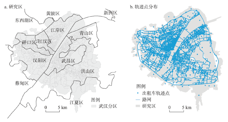
Dynamic community with life cycle is a collection of geographical entities in spatial interaction networks. They connect closely through human movement compared with other spatial entities. However, there is still a lack of systematic approaches for analyzing spatio-temporal variation. In this regard, this paper first constructs the spatio-temporal interaction multilayer network (STIMN) based on human mobility data. Secondly, we extract dynamic communities of STIMN, which reveal the uneven distribution of urban resources and the regularity and diversity of human movement. Thirdly, based on the theories of landscape ecology, we propose a dynamic community evolution model and analyze the clustering patterns, forming the framework of "the community detection - dynamic evolution - clustering analysis". Finally, we apply the framework in the third-ring core area within Wuhan, which shows that: (1) Communities extracted from public activities have similarities and differences with the existing administrative divisions of Wuhan City, which can better reflect the people-oriented urban dynamic spatial organization; (2) Community evolution shows an apparent life cycle of "occurrence - expansion - stability - contraction - disappearance"; (3) The life cycle of different communities is different. Through clustering, communities can be divided into short-term, medium-term and long-term communities. Each type of community has one or more dynamic patterns, such as stability, saddle-shaped and wave-shaped pattern, which are significant to dynamic urban planning and management. This study breaks the limitations of traditional community analysis methods, helps explore the dynamic characteristics of the STIMN and deepens the understanding of the dynamic man-land interaction.
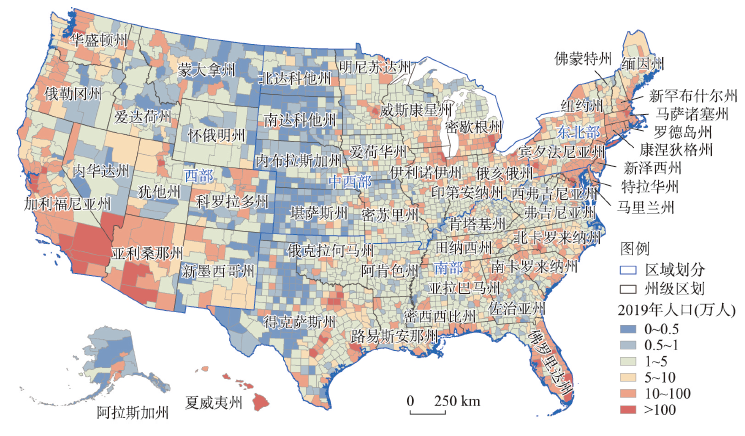
Urban scaling law quantifies the disproportional growth of urban indicators with urban population size, which is one of the simple rules behind the complex urban system. Infectious diseases are closely related to social interactions that intensify in large cities, resulting in a faster speed of transmission in large cities. However, how this scaling relationship varies in an evolving pandemic is rarely investigated and remains unclear. Here, taking the COVID-19 epidemic in the United States as an example, we collected daily added cases and deaths from January 2020 to June 2022 in more than three thousand counties to explore the scaling law of COVID-19 cases and city size and its evolution over time. Results show that COVID-19 cases super-linearly scaled with population size, which means cases increased faster than population size from a small city to a large city, resulting in a higher morbidity rate of COVID-19 in large cities. Temporally, the scaling exponent that reflects the scaling relationship stabilized at around 1.25 after a fast increase from less than one. The scaling exponent gradually decreased until it was close to one. In comparison, deaths caused by the epidemic did not show a super-linear scaling relationship with population size, which revealed that the fatality rate of COVID-19 in large cities was not higher than that in small or medium-sized cities. The scaling exponent of COVID-19 deaths shared a similar trend with that of COVID-19 cases but with a lag in time. We further estimated scaling exponents in each wave of the epidemic, respectively, which experienced the common evolution process of first rising, then stabilizing, and then decreasing. We also analyzed the evolution of scaling exponents over time from regional and provincial perspectives. The northeast, where New York State is located, had the highest scaling exponent, and the scaling exponent of COVID-19 deaths was higher than that of COVID-19 cases, which indicates that large cities in this region were more prominently affected by the epidemic. This study reveals the size effect of infectious diseases based on the urban scaling law, and the evolution process of scaling exponents over time also promotes the understanding of the urban scaling law. The mechanism behind temporal variations of scaling exponents is worthy of further exploration.