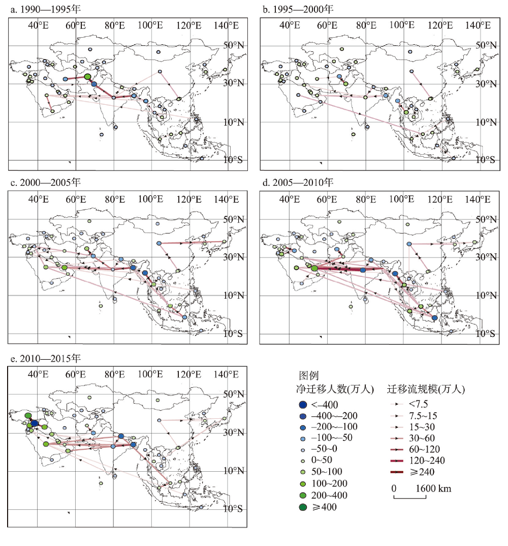
Understanding the characteristics of transnational migration in Asia is beneficial for China to formulate a reasonable international migration policy in the new era and promote the high-quality development of the Belt and Road Initiative. Based on the data of bilateral international migration flows from 1990 to 2015, this study tries to clarify the temporal and spatial patterns and influencing factors of Asian transnational migration by using social network analysis and spatial filtering panel negative binomial gravity model (ESF). The results are listed as follows: First, the main migration flows in Asia from 1990 to 2000 were concentrated in West Asia, South Asia and Southeast Asia, and most of them occurred between the adjacent countries and regions. From 2000 to 2015, there was a number of large-scale migration flows across the above three subregions. Second, the scale of the migration network in Asia is relatively low, and the degree of closeness between the Asian countries has increased first and then weakened over time. Third, political instability and war conflicts of the origin were important driving forces for transnational migration in Asia. Besides, the differences of economic development and national income between countries were the crucial driving forces, while multi-dimensional proximity factors played an important role in promoting transnational migration. Fourth, from 1990 to 2015, the effect of economic differences on transnational migration increased first and then weakened. In addition, political instability has always been the main influencing factors for migration. Besides, the development of import trade has positively promoted transnational migration, and the attractiveness of studying abroad has a fluctuating effect on transnational migration. Finally, non-economic and structural impacts were the most important factors influencing the transnational migration in Asia.
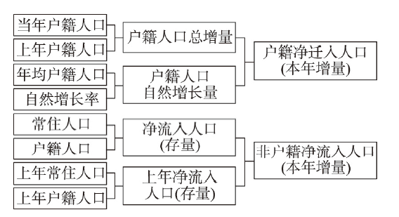
The household registration (hukou) system divides China's internal migration into two types: hukou and non-hukou migration. Hukou migration is also known as permanent migration, while non-hukou migration is temporary migration. Permanent migrants are those whose registered place is the same as their regular residence place, and temporary migrants otherwise. Most temporary rural-urban migrants without local hukou cannot obtain the same public services as urban inhabitants, which affects the improvement of the quality of urbanization. Hukou migration is the last step of population urbanization. However, existing studies mostly focus on non-hukou migration, but ignore hukou migration. Also, to connect the behaviors and intentions of hukou transfer, it is necessary to explore spatial patterns and determinants of hukou migration. The comparison and integration of hukou and non-hukou migration contributes to constructing an integrated conceptual framework of China's internal migration, which is an effective way to theorize and internationalize China's internal migration research. This paper estimates the scale of hukou and non-hukou net migration at prefecture-level cities across the country from 2011 to 2017. We analyze and compare the basic spatial patterns of the two, and explore their influencing factors. The results showed that hukou and non-hukou migration have overall similar spatial positive autocorrelation and different local clustering characteristics in inland regions. Although two types of migrants are primarily concentrated in three coastal regions, there are significant internal variations due to local urban system. It is easy to change residential location but difficult to obtain local hukou in Beijing-Tianjin-Hebei region, but totally contrast in the other two regions. The scale distribution of non-hukou migration is more polarized than that of hukou migration. We also found that the growth of the two is positively correlated with the existing floating migrants. The cities with more floating migrants will attract more hukou and non-hukou migrants to flow in. Hukou migration mainly responds to differences in economic opportunities, whereas non-hukou migration mainly responds to differences in public services such as education and health care. Non-hukou migration has gradually shifted from economic-driven migration to amenity migration, while hukou migration showed stronger market-oriented characteristics than before. But behind that, there is two-way selectivity between the big city and the talent group. Finally, the paper discusses the transformation characteristics of China's internal migration and the reform direction of the hukou system from the perspective of theory and policy. We suggest the amenity-based urban growth strategy against the context of changing residents' demands.
Based on registered population data, this paper examined a variety of population density models to explore the spatio-temporal pattern of the registered population of Nanjing during the past century. The results showed that: (1) The number of registered residents in Nanjing from 1928 to 2017 showed a flat "S"-shaped growth trend, forming an extensive dispersion with localized concentration types. The population density was the greatest in the Qinhuai River area, which has been the main registered population center. (2) The spatial structure of the registered population included: point-single center, axis-double center, enclave compound-multi center, and radiation-circle polycentric center. (3) The polycentric model, which is based on the central place theory, provided the best explanation for the features of the spatial structure of the registered population. The registered population distribution pattern in Nanjing was attributed to the joint action of four spatial location rules: the distance-decay law, allometric growth effect, spatial polarization characteristic, and regional-edge structure. (4) The transitions in the city during the past century were not a de-urbanization but a temporary fluctuation because of social transformation. Notable differences remained between traditional-Chinese residential center and the central business district.
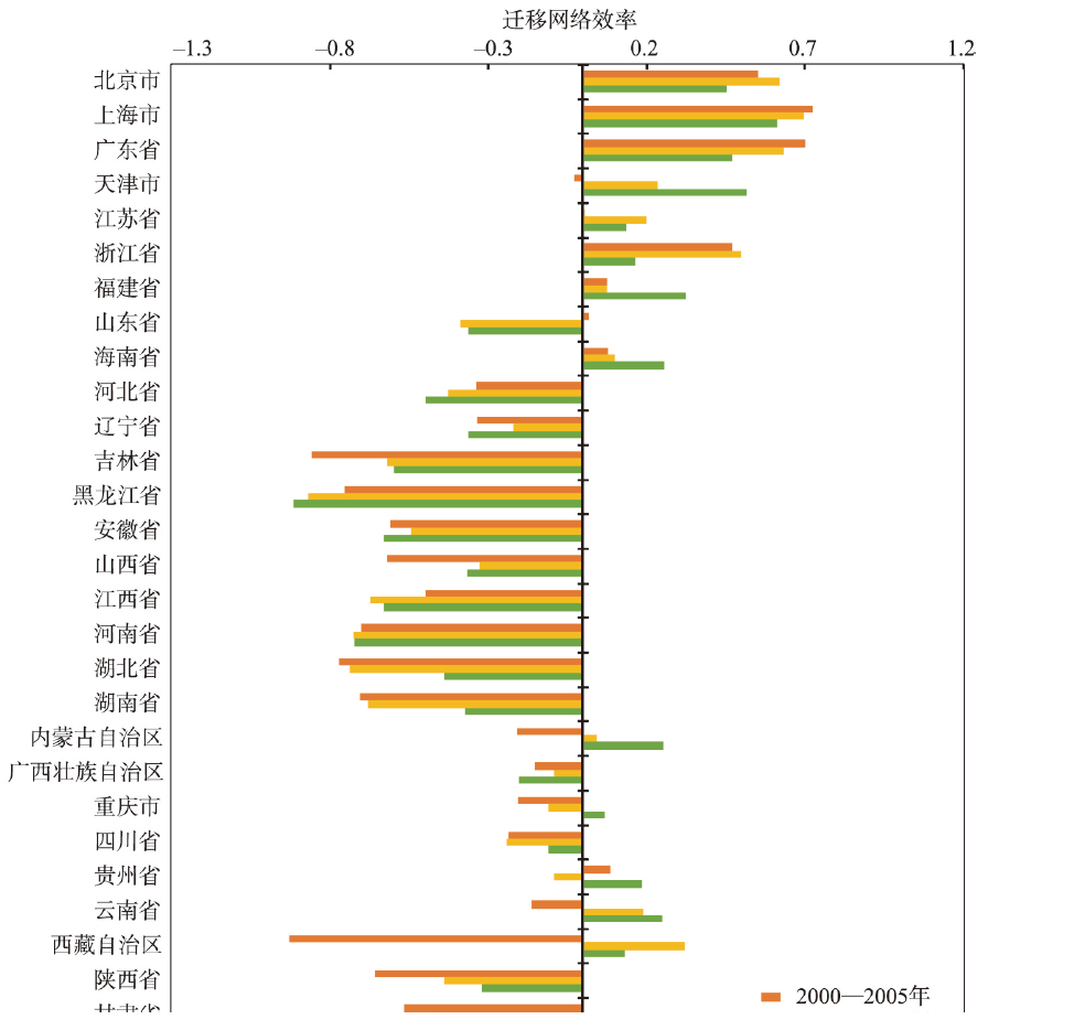
The migration of skilled individuals has become an important issue in promoting new-type urbanization in China and a key factor affecting China's regional innovation output and high-quality development. Considering the issues of zero inflation and network autocorrelation in skilled migration data, this paper combines the eigenvector space filtering (ESF) technique and the "two-stage" hurdle model into a comprehensive united framework to construct a longitudinal spatial hurdle gravity model. It then has been employed in the case study exploring the spatiotemporal patterns and influencing factors of interprovincial skilled migration in China during 2000-2015. The results are listed as follows: First, from 2000 to 2015, the mobility proportion of the skilled migration increased first and then decreased. The agglomeration pattern of skilled migration maintains the imbalance of its spatial distribution. With the elapse of time, the migration of skilled presents a dispersing trend and drives the decline of its spatial distribution and agglomeration. Talent migration presents a persistent and significant network autocorrelation, and its distribution presents a persistent and significant spatial autocorrelation. Second, China's interprovincial skilled migration during 2000-2015 was driven by gravity factors (population scales at origin and destination, distance), regional economic and scientific and technological development (average wage, spending on science & technology and education), natural amenities (average temperature difference, air quality), urban amenities (public health and education services, urban greening), and other factors (social networks, the cost of living, and population density). Third, the migration of skilled people can be regarded as a "two-stage" process, where factors affecting its migration probability and migration scale are different. Such differences are mostly reflected in factors of amenities versus economy. Fourth, the impact of economic growth, investment in science and education, natural amenities, and basic public services on skilled migration has increased over time, while the impact of wages and urban greening has weakened over time. The conclusion of this paper provides policy references for regional talent management and the balance of regional development.
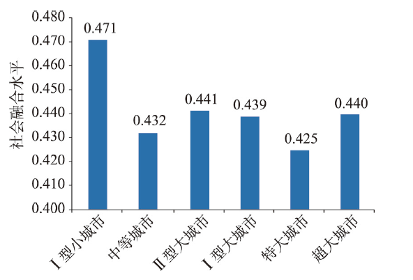
The social integration of urban floating population is the key task of the new-type urbanization in China. In view of the deficiencies of existing studies on the spatial characteristics of social integration and the role of destination city (place of inflow) factors, based on the China Migrants Dynamic Survey in 2017, this paper employs spatial analysis and hierarchical linear model to reveal the spatial pattern and influencing mechanism of social integration of migrants in cities above prefecture level in China. The results show that: (1) the overall social integration index of China's urban migrants is 0.43, which has the dimensional characteristics of behavioral integration (0.71) > psychological integration (0.61) > economic integration (0.33). (2) The social integration of migrants has spatial autocorrelation and agglomeration. The high-level social integration areas are mainly distributed in Northeast China, Shandong Peninsula, and Sichuan and Chongqing, and the low-level social integration areas are mainly found in the southeast coastal areas, Guanzhong Plain and North China Plain. These regions have the basic characteristics that the social integration level of migrants in small cities with a population of less than 0.5 million is higher than that in large cities. (3) Both the destination city and migrant individual factors jointly affect and shape the level and spatial pattern of migrants' social integration. Moreover, it is found that the population size, house price level and public services in the destination city regulate the impact of individual factors by four regulatory mechanisms: positive polarization, negative polarization, positive homogenization and negative homogenization. This paper calls for the research on the social integration of migrants from the human-land interaction perspective highlighting the relation of destination-individual factors to reveal the effect of destination factors on individual factors. This approach can provide a place-based policy implication for promoting the construction of new-type urbanization in China.
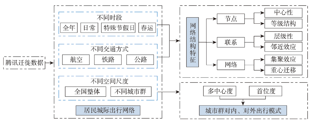
Based on the Tencent migration data in 2018, the Chinese residents' intercity travel networks were constructed respectively from different time periods (annual, daily, special holidays, and the Spring Festival travel period), different travel modes (aviation, railway, and highway) and different urban agglomerations (inside and outside). Using the social network analysis method, the spatial structure characteristics of residents' intercity travel networks were explored and depicted from the perspective of "point-line-network", and the internal and external travel patterns of major urban agglomerations were summarized to reveal residents' intercity travel laws systematically and comprehensively. The results showed that: the residents' intercity travel network in 2018 presents a spatial pattern of "dense in the east and sparse in the west", forming a top-level cross-regional "diamond" network structure with high central cities such as Beijing, Shanghai, Guangzhou-Shenzhen and Chengdu-Chongqing as the vertexes. Residents' intercity travel in the Spring Festival travel period is quite different from that in other holidays. The weighted gravity center of the residents' intercity travel is more inclined to the southwest during the Spring Festival travel period. The daily average travel scale of the Spring Festival is higher than that of other periods. There are significant differences in residents' intercity travel population scale, travel range and travel transportation network under different travel modes. The aviation intercity travel, railway intercity travel and highway intercity travel are responsible for the population gathering and dispersion of intercity travel at national level, regional level and local level, respectively. The internal and external residents' intercity travel networks of urban agglomerations respectively show a spatial pattern of "core-hinterland-periphery" and "region crossing-neighboring-locality", with obvious significant hierarchy. Affected by administrative barriers, intercity travel within an urban agglomeration is more to the capital city as the origin or destination, showing a multi-center dual-core travel pattern, while the external intercity travel of the urban agglomeration is mostly single-center single-core travel pattern.
Urban boundaries are the spatial basis for the cognition of urban evolution and urban planning decision-making. In China, "city" usually refers to a legally defined administrative unit, whose spatial boundary does not coincide with that of physical entity consisting of a continuous artificial impervious surface. However, few studies quantitatively analyze the temporal and spatial evolution of urban physical areas over long time series, especially lacking a systematic understanding of the spatial differences in urban land expansion from the views of physical and administrative areas. Based on the multi-source remote sensing products with a spatial resolution of 30 meters, we identified the physical urban boundary from 1988 to 2018 and analyzed the land expansion process of the physical area. Further, we identified the cognitive differences and spatial patterns of urban land expansion from the above two views and found the following conclusions: (1) In the past 30 years, the number of urban physcial areas in China with an area of more than five square kilometers has increased by 378%, and the most significant growth is in East and Central China. Among the physical areas, 88% of them belong to the type of "independent growth" widely distributed but most of them are smaller than 50 km2, while the other 12% belongs to the type of "spatial aggregation", mainly distributed in developed areas and the area is generally large. (2) Compared to administrative units, the rank-size distribution of urban area is more complying with the power-law model. Its Zipf's exponent has gradually increased to 1 in the past 30 years, indicating development of the urban system has become more and more balanced. Compared to physical areas, administrative area have larger land expansion area in plain areas and lower land expansion intensity in coastal areas. (3) The 1327 county-level administrative units that cannot topologically match the urban physical area are mostly distributed in densely populated or developed plain areas. Combining two views, two types of spatial expansion have been further identified, namely "inter-districts co-urbanization" and "intra-district clustering". The former occurs in provincial capital area, while the latter is mainly distributed in the developed areas of the North China Plain. Both reflect the spatial reconstruction of urbanization. This research is helpful to deepen the understanding of the spatiotemporal process of China's land urbanization and provide decision support for scientific land resource management.

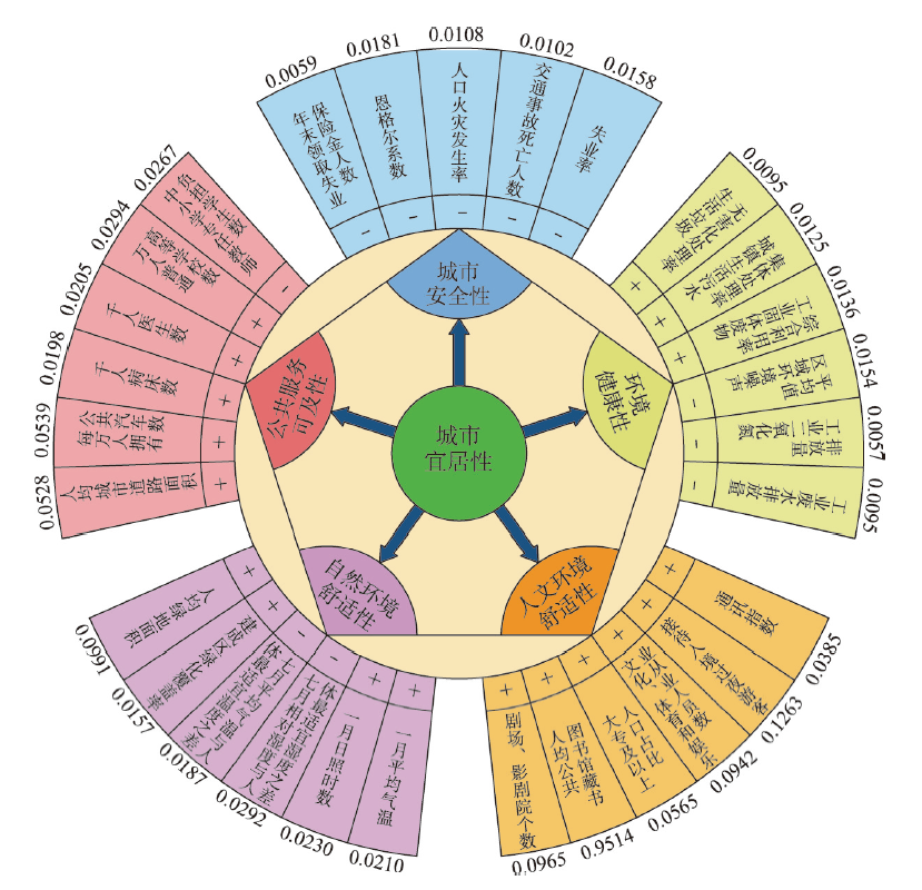
Under the background that economy and urbanization of China are gradually entering the stage of high-quality development, clarifying the influence of economic development on urban livability is of significant academic and practical value. In this paper, regarded as one "factor", livability was introduced into the research framework of production function, and a theoretical model of the impact of economic development on urban livability was established. Based on the panel data of 40 cities in China from 2005 to 2019, the System GMM, panel threshold model and other methods were further adopted to carry out an empirical analysis. The results show that: (1) The livability level of large and medium-sized cities in China from 2005 to 2019 has been rising generally, but they present obvious characteristics of dimensional and spatial differentiation. (2) In general, economic development has an inhibiting effect on the improvement of urban livability, but this logical effect shows obvious heterogeneity in different time periods and diverse city scales. This inhibitory effect is more significant for the cities before entering the new normal phase of economy, and large-scale municipalities and economically-developed provincial capitals (namely Class-A cities). (3) There are significant threshold effects in the impact of economic development on urban livability, where the threshold variables are income level and economic development. With the increase of city dwellers' income, this effect presents an inverted N-shaped nonlinear feature. When the development of economy makes the average wage of employees between 60000 and 80000 yuan, economic development can significantly improve urban livability. Also, there is a significant single threshold inhibitory effect when economic development is taken as a threshold variable. However, its negative impact shows a law of diminishing marginal efficiency. In addition, a similar threshold effect is found in smaller-scale Class-B cities. The findings of this research can provide some insights for urban planners and policymakers in both China and vast developing countries to understand better the relationship between economic development and urban livability. Finally, according to the research findings, we proposed the corresponding policy enlightenment from both "macro guidance" and "micro action".
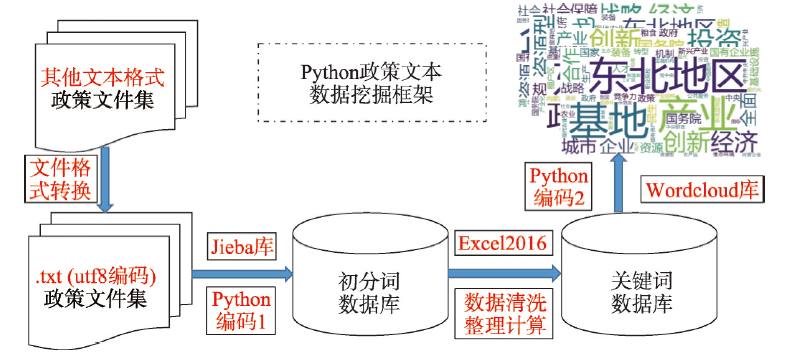
This paper reviews a series of policies on Northeast Revitalization which were issued by the central and the local governments from 2003 to 2020. The authors analyze the relevant policies from three spatial dimensions, including the national, the provincial and the municipal levels, and deconstruct the policies in three attributes: hierarchy, type and time series. The analysis of the selected policies is assisted by Python's self-programming in text data mining. Lastly, the authors evaluate the effects of regional economy and the reformation of state-owned enterprises driven by the policies of Northeast Revitalization. The results indicate that: (1) The central government, the provincial-level regions and the prefecture-level cities have issued a series of policies in response to the Northeast Revitalization, forming a complex policy system with multi-type, multi-level and multiple time nodes. (2) The formation and transformation of Northeast Revitalization policy system has the characteristics of stability, continuity, timeliness and regionality. (3) The policies of Northeast Revitalization has a positive effect on the growth of reginal economy in a long run, however, the local governments highly depend on the policies, which leads to significant economc growth in the short term, but poor persistency for long-term development. (4) With the support of the policies, the reform of state-owned enterprises is strengthened and innovative achievements are made, yet, the challenges in the development of techniques cannot be neglected.
Relocating government seats is a city administrative strategy for optimizing space and structural organization, and for promoting economic development through re-allocation of urban space resources. However, there is a disconnect between the central government's current cautious attitude toward government relocation, and local government's actual benefits from such relocation, which reinforces the demand for policy evaluation research. Previous studies paid insufficient attention to the impact of urban government relocations on the overall economy, and lacked empirical evidence of large samples. This paper uses China's urban panel data from 1996 to 2016, and adopts a Difference-in-Difference approach based on Propensity Score Matching (PSM-DID) to examine the effect of urban government relocation on economic growth. The results show that urban government relocations significantly promote urban economic growth. However, other urban characteristics will also affect the economic growth effects of relocation, and produce heterogeneous results. Among these, urban characteristics such as migration distance, economic development level, fixed asset investment rate, and government intervention amplify the economic growth effect of relocation, while the growth of construction land reduces it. The size of the city, on the other hand, has no significant regulating effect on the economic growth generated by government relocation. From the perspective of the time, the long-term economic growth created by urban government relocation increases after about 7 years of relocation. The findings of this paper not only support the positive effect of urban government relocations on a city's economic growth, and provide an academic basis for optimizing administrative divisions adjustments, but also provide an important resource for the governments in considering the relocation plans for local administrative centers.
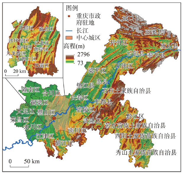
A clear ecological restoration zoning of territorial space is the prerequisite and foundation for the orderly implementation of land remediation and ecological restoration projects. Chongqing is the last gateway to the ecological barrier of the upper reaches of the Yangtze River, with a prominent strategic position in the ecological security pattern of China. Taking Chongqing as an example, this study explored the framework of ecological restoration zoning based on the adaptive cycle model, constructed an index system to evaluate the spatio-temporal characteristics of the three-dimensional attributes of potential, connectedness and resilience of the city's territorial space system, identified the adaptive cycle phase of each county, and discussed its ecological restoration of territorial space. The results show that: (1) The spatial distribution of three-dimensional attributes in the study area from 2000 to 2020 presents a pattern of high in the east and low in the west. Most of the counties in Chongqing are in the reorganization phase, exploitation phase and coordinated exploitation phase, a few are in the conservation phase, and no county has yet entered the release phase. (2) Ecological restoration zoning of the city includes 4 zones and 9 subzones. In general, the ecological restoration zone focuses on systematic ecological restoration projects in built-up areas and strengthen comprehensive environmental improvement and treatment efforts; the ecological enhancement zone should gradually improve the implementation standards of ecological protection and restoration projects, optimize the coordination of various ecological elements, and enhance comprehensive ecological benefits; the ecological control zone should limit the intensity of territorial space development and reduce the negative impact of human activities on ecosystems; the ecological conservation zone should optimize the functions of natural ecosystems and strengthen the management of ecological reserves and the solution to ecological problems.
International trade of agricultural products plays a crucial role in national food security in China. Using the methods of normalized trade balance index, Hirschman index, Hilbert curve, ridge regression, and visualization analysis, this paper analyzes the evolution of China's agricultural trade structure from 1992 to 2020 and its relationship with food security. This paper finds that: (1) The pattern of China's agricultural trade changed significantly from 1992 to 2020, characterized by an increasing dependency on imports. The trade of agricultural products, such as pork, beef, corn, sorghum, and rapeseed, shifted from exports to imports. The rapid growth of imports which directly increased domestic food supply has improved food security in China. (2) The imports of agricultural products present a combined effect of product structure and spatial structure. As a result, the imports of key agricultural products are likely to be affected by the trade policy changes in some countries such as the United States and Australia. In contrast, the exports of agricultural products show a low concentration. The trade with countries and regions along the Belt and Road has dramatically expanded the exporting destinations, and significantly lowered the geographical concentration of exports. A low level of concentration has helped to ensure the economic benefits of exports and stabilize agricultural production in the export sector. (3) Agricultural production in China has showed an inclination to reduce the production of some imported products. Coupled with the highly concentrated import structure, domestic agricultural production and food security will be vulnerable to external shocks. Based on the findings, it is suggested to optimize the import and export structures of agricultural products, and guide proper agricultural production while adhering to trade openness.
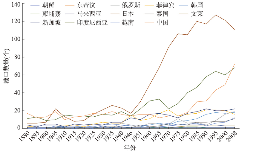
With the signing of the Regional Comprehensive Economic Partnership (RCEP), Asian integration has entered a new stage. Two major issues need to be clarified: what are the characteristics of interconnectivity between ports in the "Asian Mediterranean" over time, and what are the patterns of port connectivity in the process of trade integration. This paper uses maritime route data from 1890 to 2008 to construct a dataset of shipping networks with long time series. The characteristics of shipping connectivity in this region are studied from two dimensions of port function and shipping connectivity, and the Michael Porter Diamond Model is adapted to analyze the evolutionary mechanism. The main conclusions are drawn as follows: (1) From the perspective of the strength and breadth of connection between ports, Japanese ports rose to prominence before World War II. After that, Singapore and Hong Kong maintained their hub status for a long time. Since the reform and opening up in the late 1970s, and particularly after China became a member of the WTO in 2001, the volume of traffic in Chinese ports has grown rapidly. (2) In terms of the transshipment function, there was little difference in the transshipment capacity of ports before World War II. After World War II, Singapore, Hong Kong, and Busan successively become the three major transit hubs in the southern, central, and northern parts of the Asian Mediterranean. (3) The long-term port connection has gone through four stages: the disorderly distribution of shipping lines (from the 1890s to the 1920s), the formation and development of the maritime network (after the 1930s), the emergence of multiple hub ports (since the 1950s), and regional port cluster development (since the 1990s). (4) Factor conditions and management policies facilitate the long-term stability of ports. Port prosperity is driven by demand conditions and external opportunities. Replacement of managers profoundly impacts port organization patterns. Port connectivity is influenced by enterprise strategies and inter-port competition. The long-term dynamic law shows that in general, the port network tends to move from fragmentation to integration. A small number of ports have long been ranked in the first echelon due to their superior geographical locations on land and sea. The post-developed ports and non-hub ports should be actively integrated into the pattern of route interconnection.
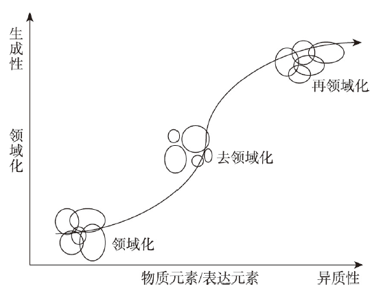
Against the background of the French "May Wave" and the postmodernist, the theory of assemblage as a research perspective starts to gain momentum. This paper proposes a philosophical view of "becoming" based on rhizome thinking, which critically exposes ignorance of the spatial topology in the current research based on network structure and opens up a new field of the knowledge for human geography. On the one hand, the assemblage theory forms a "heterogeneous generated space" on the basis of spatial theories such as "spatial production theory", "heterotopia" and "third space", emphasizing the interactions of the heterogeneous elements while also paying attention to the logic of the continuous generation and spatio-temporal change; on the other hand, the assemblage theory reconstructs the concept of relations, emphasizes the "object agency" and "relations of exteriority", which generates the "post-relational ontology" and acknowledges that all things are assembled through relations. With the application of the assemblage theory in the field of human geography, the existing empirical research mainly focuses on political assemblage and mobility, urban assemblage and critical urbanism, daily life assemblage and non-human agency, and compared with other related theories such as Complexity Theory and Actor Network Theory. In order to expound the connotation of the assemblage theory and enhance the applicability of the theory, the article analyzes the assemblage logic through border assemblage. In addition, based on the new research framework and theoretical paradigm constructed by the assemblage theory for human geography, as well as the coupling of the theoretical characteristics and the transitional period of Chinese society, it is expected that Chinese geographers can critically engage into the assemblage theory to explain the Chinese situation, as well as promoting the diversities of the Chinese geography theory and philosophical methodology.
Socioeconomic statistical data is usually aggregated in units of administrative regions. The socioeconomic statistical data can reflect the heterogeneity between statistical units, but it cannot reflect the heterogeneity within a statistical unit. The socioeconomic statistical data cannot meet the needs of socioeconomic departments concerned in arbitrary regions. The spatial disaggregation of socioeconomic statistical data is an effective way to solve this problem. This study summarizes the existing methods of spatial disaggregation of socioeconomic statistical data, the auxiliary data used in methods for obtaining spatial disaggregation of socioeconomic statistical data, and the main socioeconomic grid data products. This study also predicts future development trends of the spatial disaggregation of socioeconomic statistical data in three aspects: the constraints and improvement directions of methods, the exploration of new auxiliary data and the comprehensive utilization of multi-source auxiliary data, the development of high temporal and spatial resolution and high-precision grid data products. The research results can provide references for the selection and improvement of spatial disaggregation methods of socioeconomic statistical data, the selection and comprehensive utilization of auxiliary data, and the selection and improvement of socioeconomic grid data products.

Based on materials mainly comprising name lists, biographies, short introductions, dictionaries of/on geographers, historical records overviewing colleges and universities, histories of geography departments, and so on, this study aims at revealing the development process of geographers in China in the period 1912-1949 from a ternary perspective of source, growth, and structure. The key data on geographers' birth and death years, native places, subdisciplines or fields they contributed to, and their educational and working backgrounds are extracted and used to identify geographers and evaluate their development process. A total of 460 geographers (449 Chinese, 11 foreigners) are identified. The research reveals the following: First, geographers can be categorized into three types: traditional, foreign, and scientific cultivation (including domestic trained, overseas trained, and interdisciplinary scholars), and the changes in geographer type reflected the change of disciplinary traditions. Second, the development of geographers can be divided into four periods: initial growth (1912-1927), continuous growth (1928-1939), rapid growth (1940-1941), and slow growth (1942-1949). Third, the distribution of Chinese geographers' subdisciplines or fields, research directions, native places, ages, and gender showed a pattern of obvious unbalance but continuous optimization. Finally, the development of geographers was closely related to the establishment of teaching and scientific research institutions. The higher teaching institutions had a "double-track" effect (employing and training) on the development of geographers in terms of recruitment and training. In particular, the contribution of university geography departments to the cultivation of geographers was characterized as the "double-track" system related to the types of universities and departments. Geoscience departments in comprehensive universities and those jointly established with geology and meteorology departments made outstanding contributions to the development of geography, while geoscience departments in universities tended to train physical geographers. Overall, the number of geographers in China, particularly Chinese geographers, and the rate at which that number increased were considerable, albeit unevenly distributed over time. Notably, the development of Chinese geographers from 1912 to 1949 laid a solid talent foundation for the further development of Chinese geography after 1949. The progress of the development of Chinese geographers from 1912 to 1949 was also remarkable, and was the result of the efforts of senior, outstanding, famous, young, and female geographers, and the participation of foreign companions.
