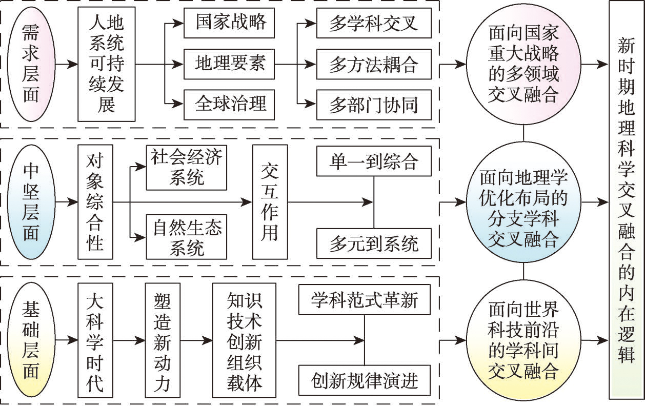
With the progress of holistic science and human society, development of geographical sciences has entered a new stage of interdisciplinary integration. Under this context, geographical sciences urgently needs to seek new paths through the deep integration of disciplines to better improve the knowledge system and contribute to the country and society development effectively. Based on the perspective of the National Natural Science Foundation of China (NSFC), this paper firstly deeply analyzes the current status and problems of the integration and development of geographical sciences in China, and points out that it is not fully integrated with the frontier of international geographical sciences, and the global political, economic and cultural influence of geographical research in China needs to be strengthened; considers that the ability of Geographic Sciences integrating national major practical needs for theoretical and technological innovation should be improved; suggests that the internal discipline system of geographical sciences in China should be further optimized according to the needs of knowledge integration. Then, this paper proposes three paths for the integrated development of geographical sciences under the guidance of funding policies, that is, the interdisciplinary integration facing the frontiers of science and technology in the world, the multiple fields integration facing the major national development strategies, and inner-discipline integration facing the optimized application codes of NSFC. In future, based on maintaining the continuity and stability of the development of disciplines, the NSFC will encourage the integration of geographical sciences with other disciplines and fields through the improvement and innovation, so as to promote and build a healthier and more innovative system.
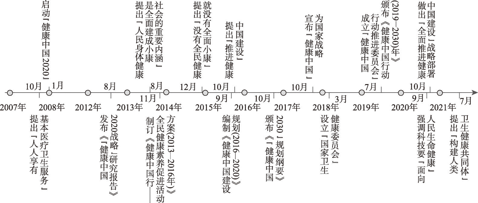
The interaction between health and environment is the most essential man-land relationship. Geography plays a significant role in the construction of Healthy China. It can provide path guidance based on development strategy, process evaluation and policy orientation, theoretical guidance based on man-land relationship harmony and spatial system optimization, and practical guidance based on healthy life, health service, health environment, health security and health industry layout. Combining the disciplinary characteristics of geography and the five key areas of the construction of Healthy China, geography could play a unique part in the 18 aspects, including sub-disciplines of health geography, tourism geography, economic geography, urban geography, behavioral geography, population geography, information geography, social geography, cultural geography, rural geography, and environmental geography. First, it promotes healthy life in areas of regional residents' health literacy, living style, and spatio-temporal behavior, as well as regional population mental health. Secondly, it improves healthy service in areas of disadvantaged people health service, major diseases prevention and control, and sustainable health in key regions. Thirdly, it constructs an environment in areas of healthy eco-environmental construction, healthy climate change response, environmental health risk detection, healthy urban and rural environmental construction, and healthy cultural landscape construction. Next, it enhances healthy protection in areas of geographic information system (GIS), optimization of medical resource allocation, healthy services accessibility, and fairness. Finally, it develops healthy industry in areas of development of local medicine and traditional Chinese medical industry, healthy tourism and entertainment, optimization of senior care, maternal and infant industry. However, nowadays, the contribution of geography in building the Healthy China is limited because of the following reasons: (1) weak basis for health geography; (2) lack of strong sense of participation; and (3) lack of policy support from geographical organization. In the future, more research should be focused on problem-oriented and policy-oriented geographical theory, empirical and policy research, health promotion research of deep integration of geographic technology and thinking, and systematic guidance and policy support for geographers to participate in the construction of Healthy China.
The history of Chinese economic geography as a research field is virtually an evolution of ideas on the relationship between economic activities and geographical environment. In ancient times, the idea on adapting to geographical conditions to cultivate economic activities had emerged, and numerous cases of regional practices were recorded in local chronicles. In the period from 1840 to 1948, economic geography appeared as a scientific discipline, and relevant research on agricultural and industrial geography was carried out. In the period from 1949 to 1978, the ideas on economic geography of the Soviet Union were fully introduced, with research focusing on the use of natural conditions and resources, and on the relationship between production distribution and geographical contexts to meet the national needs of economic development. In the period from 1979 to 2000, starting from territorial management and land planning, the important perspective formed on the relationship between man and land, and the theoretical progress was made in the establishment of Point-axis Concept and other spatial structural patterns. Economic geographers also made proposals on government regulations based on an expanding trend of regional differences. In the period from 2001 to 2020, one of the foci related to the relationship between man and land was the major fuction-oriented zoning, and other hot topics included issues of industrial agglomeration, urban economic zones, rural revitalization, and the impact of new factors on formation mechanism of the spatial structure of economic activities. The development of Chinese economic geography thought can be sorted into three threads. The first one is the long-lasting records that consist of rich historical documents, from the description of a large number of economic locations and differences of their geographical contexts, to the exploration of the relationship between economic activities and geographical environment. Together with a large number of local chronicles, the idea of man-land relations was hidden in the text. The second thread is the trajectory of travel notes which was developed into modern investigations and observations, providing important means of discovering scientific facts for the study of economic geography. The third thread is the introduction of ideas from other countries including investigation techniques, research methods and thinking logic, which further promotes the development of China's economic geography. The survey on the history of economic geography ideas can provide three enlightenments for further study of economic geography: (1) strengthening the exploration of the relationship between economic activities and the geographical environment; (2) encouraging problem-oriented critical thinking; (3) improving the weaknesses of China's economic geography research, such as the reduction theory and the deductive method.

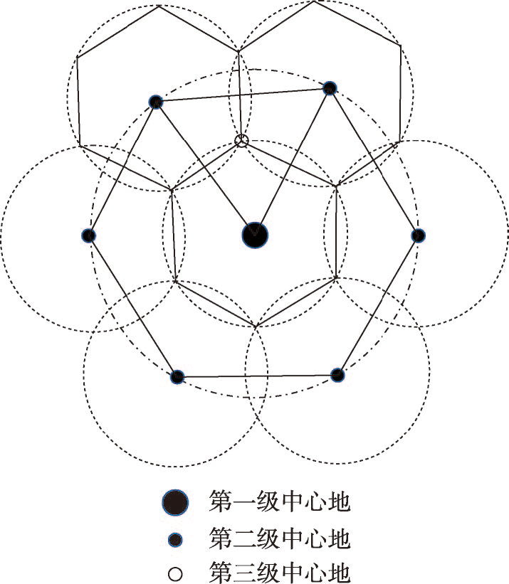
This study addresses the deficiency in explaining the meaning of the market principle of k = 3 in central place theory. Two contrasting views of explanation-a top-down view by Christaller vs a bottom-up view by Hagget-exist in the literature. As for Christaller, all parts of a region are required to obtain all possible central goods from as few central places as possible that are in operation. As for Haggett, "where the supply of goods from central places is to be as near as possible to be the dependent places a k = 3 hierarchy is indicated, since this maximizes the number of central places". The distinctive views allow us to rethink about the meaning of the market principle in central place theory. We propose that given the condition that central places follow an equilateral triangular distribution with hexagonal markets and that a central place on the higher-level provides goods in both longer- and shorter-distance market ranges, and two adjacent levels of central places, one on the higher level and the other on the lower one, shall have overlapping markets as much as possible (or the size of their market area (or hinterland) should be as close as possible), so that the difference in the market size of the two central places is minimized to reduce the type of goods that could be excluded from them due to maximum or minimum requirement on market ranges. This newly proposed perspective integrates the two existing contrasting views of explanation made by Christaller and Hagget and can be deemed as a reasonable and fair explanation of the market principle of k = 3 in central place theory. It should be noted that this view was first proposed in the textbook Advanced Economic Geography (Chinese version) edited by the author together with Professor Wuyang Yang in 1997. This view can also be verified by LÖsch's central place model, that is, central places built upon the market principle should minimize producers' spatial monopoly and profit.
Urbanization in the Qinghai-Tibet Plateau is a special mission in defending the national security, the national ecological security and the Asian Water Tower. It plays an irreplaceable role in the world, which ensures the realization of modernization, the happiness of all ethnic groups, a stronger ecological security and a more solid national security barrier in this region. This study discusses in detail the special driving force, development path, development goals, development pattern, green development mode and green development path of new urbanization in the Qinghai-Tibet Plateau, which are completely different from the inland areas. It is believed that the urbanization of the Qinghai-Tibet Plateau is a process characterized by low-level development, cultural inheritance, national defence, water tower protection, small agglomeration and large dispersion, social inclusion, and ecological enrichment. It is driven by a single investment, tourists, services, and counterpart support in an alpine and anoxic environment. In the future, the urbanization development thinking in the Qinghai-Tibet Plateau is, firstly, to take the defence of the territory and the border as the guideline to ensure national security, and a sufficient population in the border and rural areas at a fast, stable and appropriate growth rate. By 2035, the permanent population of the plateau will reach 16 million, and the urbanization rate should be 52.5%, which will be stable in the middle stage of urbanization for a long time, and the quality of urbanization will be promoted comprehensively. Secondly, driven by green development, the ability and level of ecological products and ecological services will be continuously improved, highlighting characteristics and folk customs, and promoting cultural diversity and inclusiveness. And we encourage local herdsmen to live in the town and graze in the township so that they can build beautiful cities and towns and advance in-situ urbanization on the plateau. Thirdly, based on the principle of small agglomeration and large dispersion, the pattern of borderland security urbanization is composed of "three circles, four belts and multi-nodes", emphasizing the agglomeration effect of the three circles (Xining metropolitan area, Lhasa metropolitan area, and Qaidam urban circle), four belts (urban belt along the Qinghai-Tibet Railway, urban belt along the Sichuan-Tibet Railway, town belt along the Tangbo Ancient Road, and border town zone), and multi-nodes (multiple important urban nodes, and important border towns). Fourthly, we should guarantee the channel development, including the construction of new infrastructure facilities such as the Qinghai-Tibet high-speed railway, and the building of plateau smart cities, so as to safeguard national security. Finally, taking territorial security as a top priority, we should speed up the reform of the land system in border cities, set up pilot special zones for borderland land reform, and focus on border cities in major national strategic layout and territorial spatial planning.

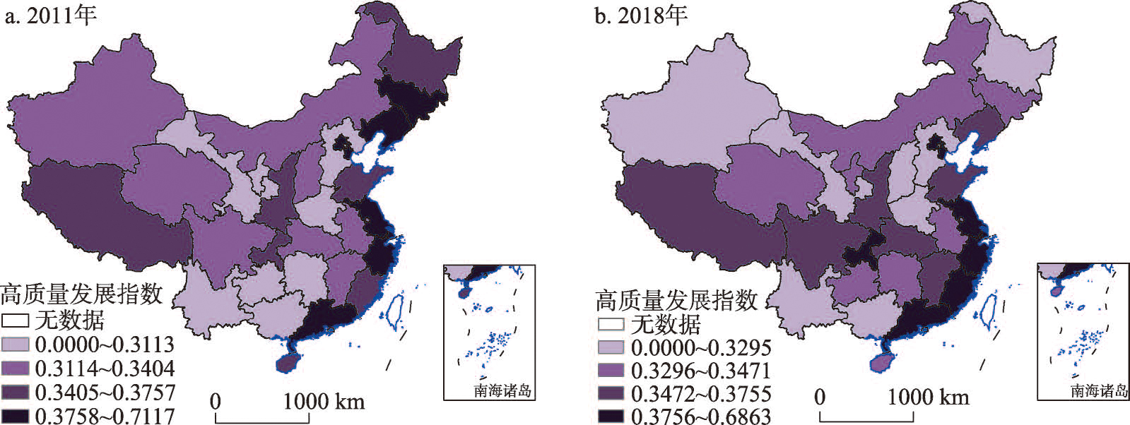
High-quality development is the main focus of China's economic and social development in the 14th Five-year Plan (2021-2025) and even in a longer period. It is also the basic requirement to adapt to the changes of the main social contradictions and the key path to build a modern socialist country and the fundamental place to follow the law of economic practice. This paper constructs an evaluation index system of high-quality economic development from five dimensions of innovation, coordination, green, openness and sharing, and measures the high-quality economic development level of China's provincial-level regions from 2011 to 2018. On this basis, social network analysis (SNA) and quadratic assignment procedure (QAP) are used to analyze the structural characteristics of the associated network of high-quality economic development and the mechanism of the difference of high-quality economic development. The results show that: (1) The correlation degree of spatial correlation network has always been 1, and the network density is stable, between 0.2 and 0.26. The spatial correlation network with high-quality development of inter-provincial economy has strong accessibility, multi-overlap and certain hierarchy, but the correlation tightness needs to be improved, and the network indicators remain relatively stable. (2) The spatial association network of inter-provincial high-quality development can be divided into four sections, among which the "net spillover" section with western provinces as the main section benefits the least; The "agent" plate, which is dominated by the central provinces, plays the role of "intermediary" and "bridge"; The "bidirectional spillover" plate dominated by provinces in the Bohai Rim and the "net beneficial" plate dominated by provinces in the Yangtze River Delta and southeast coastal areas play a greater role in controlling and dominating the spatial association network, and exert a greater effect in polarization rather than trickle down in the process of high-quality development of national economy. (3) The regional differences of human capital, urbanization level, financial technology and environmental quality will directly lead to the differences of high-quality economic development level between regions, among which, the difference of human capital contributes more than 90%.
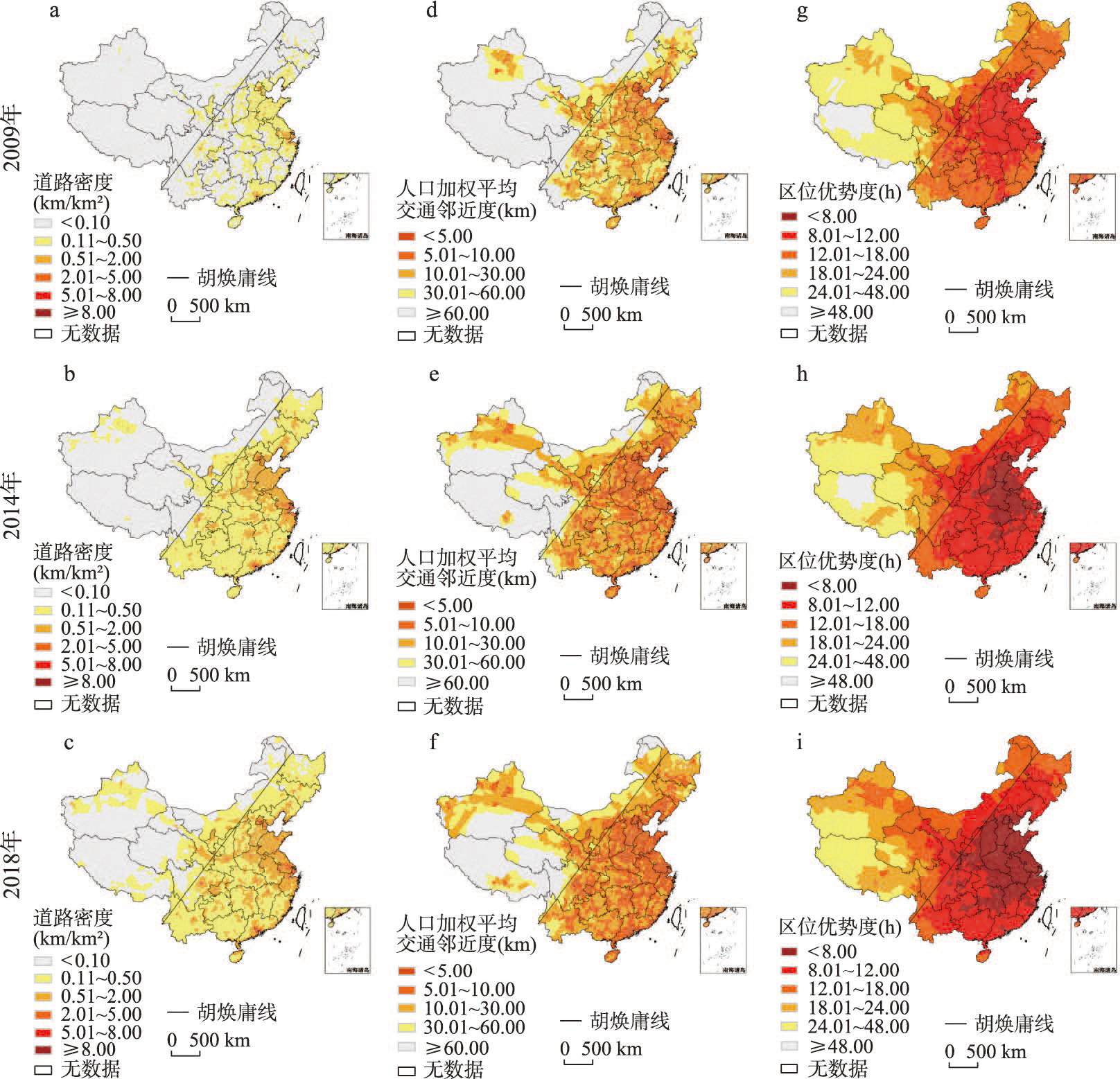
Overland transportation is the fundamental support of regional economic and social development. Based on the national data about overland transportation in 2009, 2014, and 2018, we develop an evaluation model of transportation dominance involving three dimensions, namely, scale, proximity, and accessibility. These dimensions are interpreted by road density, population-weighted average transportation proximity, and location advantage, respectively. We further reveal the spatial pattern and evolution of overland transportation dominance and then estimate its economic effect. The results show that: (1) Significant progress has been made in China's overland transportation from 2009 to 2018. Overland transportation dominance expands from urban intensive areas to inter-regional channels, which is closely related to the urbanization strategy called a "two horizontal and three vertical" pattern. The inferiority of overland transportation is mainly found in the western, northeastern, and provincial border areas. These areas are the key to balanced transportation development to make up for the current shortcomings. (2) The spatial patterns of the overland transportation dominance are different in different regions and development stages, which can be abstracted as the evolution of "pole-and-core, point-and-axis, and hub-and-spokes". Future transportation development should strengthen the connection between important regions, the main transportation axes, and the key transportation corridors. (3) The overall economic effect of overland transportation dominance is significantly positive, and its indirect effect is about 1.5 times as large as the direct effect. However, transportation does not always promote county economic growth, whose sub-dimensional economic effect varies in different regions and periods.
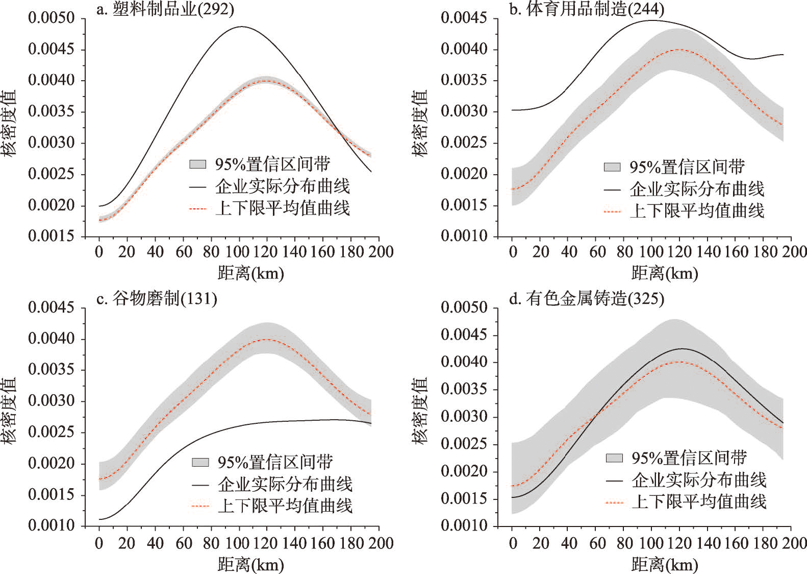
Industrial agglomeration is a highly prominent geographical feature of economic activities, and it is an important research topic in economic geography. However, mechanism-based explanations of industrial agglomeration often differ due to a failure to distinguish properly between the spatial distributions of industries and the stages of industrial agglomeration. Based on micro data from three national economic censuses, this study uses the Duranton-Overman (DO) index method to calculate the spatial distribution of manufacturing industries (three-digit classifications) in the Beijing-Tianjin-Hebei region (BTH region hereafter) from 2004 to 2013 as well as the Hurdle model to explain quantitatively the influencing factors and differences in the two stages of agglomeration formation and agglomeration development. Our research results show the following: (1) In 2004, 2008, and 2013, there were 124, 127, and 129 agglomerations of three-digit industry types in the BTH region, respectively. Technology-intensive and labor-intensive manufacturing industries had high agglomeration intensity, but overall agglomeration intensity declined during the study period, from 0.332 to 0.261. (2) There are two stages of manufacturing agglomeration, with different dominant factors. During the agglomeration formation stage, the main locational considerations of enterprises are basic conditions. Agricultural resources and transportation have negative effects on agglomeration formation, while labor pool and foreign investment have positive effects. In the agglomeration development stage, enterprises focus more on factors such as agglomeration economies and policies. Both internal and external industry linkages have a positive effect, with the former having a stronger effect, while development zone policies and electricity, gas, and water resources have a negative effect. (3) Influencing factors on industrial agglomeration have a scale effect, and they all show a weakening trend as distance increases, but different factors respond differently to distance.
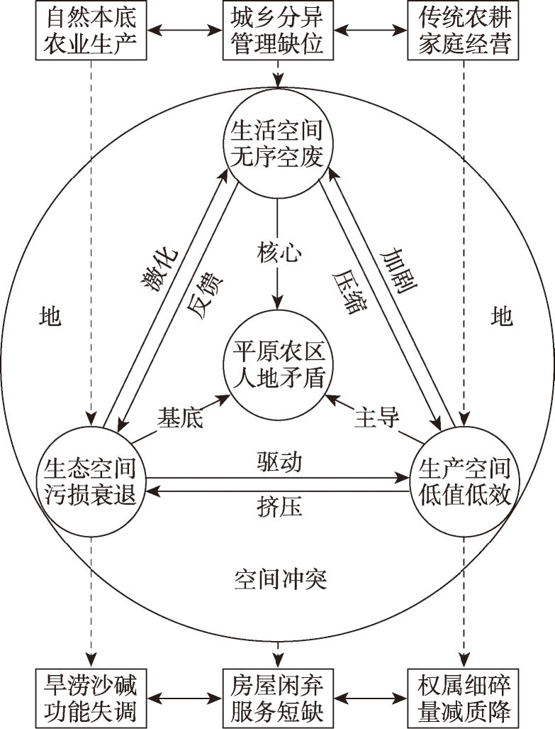
Plain agricultural areas are the core areas to ensure national food security. The coordination of comprehensive land consolidation and rural transformation development is of great importance in the alleviation of the multiple pressures of economic development, arable land protection and ecological conservation in plain agricultural areas, and guarantees the implementation of rural revitalization policies. We used the framework of "problem interpretation", "strategy refinement", "mechanism construction", and "empirical test" to explore the coordinated mechanism between comprehensive land consolidation and rural transformation development. The results show that: (1) There are significant conflicts in the utilization of "production-living-ecology" space in plain agricultural areas. The low value and inefficiency of production space, disorder and disuse of living space, as well as pollution and decline of ecological space jointly restrict the development of rural transformation. (2) The comprehensive land consolidation strategy for the promotion of land value, the improvement of living environment and the integrated development of industries is conducive to promoting rural transformation development. (3) In the new period, comprehensive land consolidation has been changed from "land-oriented" regulation to "human-land-industry-right" consolidation, and right reorganization, space reconstruction and reshaping of industry are the key mechanisms to promote the coordination of comprehensive land consolidation and rural transformation development. (4) Yucheng City, a typical plain agricultural area, focuses on the land-ownership adjustment, hollow village remediation and modern industrial cultivation, so as to realize the synergistic promotion of comprehensive land consolidation and rural transformation development. This study contributes to the deepening of the new scientific understanding of human-environment system in plain agricultural areas, and provides practical reference for developing the modernized space governance system and comprehensively promoting rural revitalization.
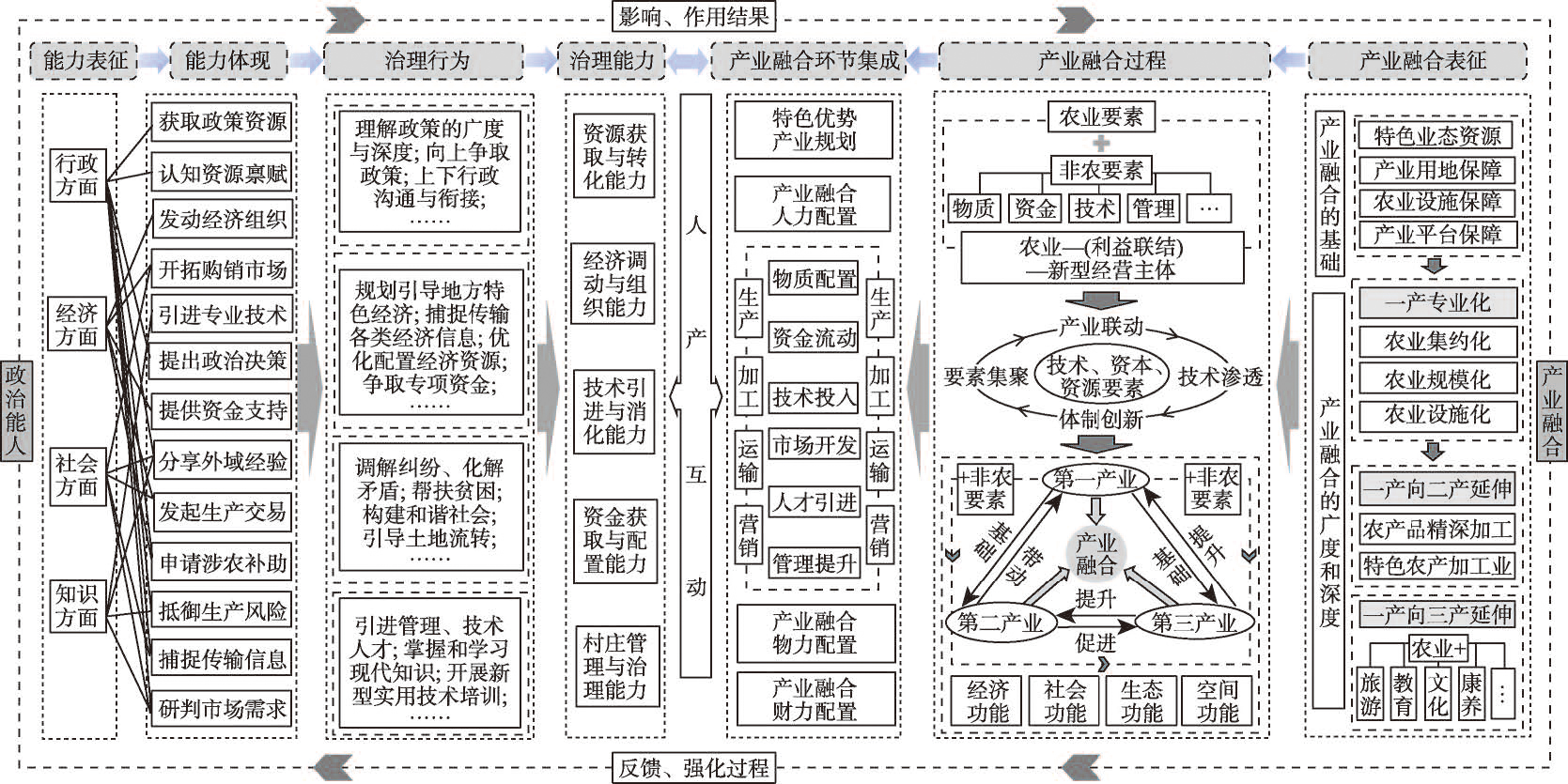
Rural governance is the foundation of China's governance system. Integrated industrial development is the core of rural revitalization and it is also an important aspect of rural governance performance. Under the current governance model of "Township Administration and Villagers' Autonomy", political elite replaces traditional village elite to become the new main body of rural governance. Exploring the coupling relationship and mechanism between its governance ability and industrial integration development is of great and far-reaching significance for realizing the rural revitalization and constructing the governance system of "three-in-one". On the basis of a systematic review of the coupling relationship and mechanism framework of the rural political elite governance ability and industrial integration development, this study constructs an evaluation index system of political elite's governance ability and rural industry integration development respectively. Taking 139 administrative villages in Jinchang City of Gansu Province as evaluation units, this paper reveals the coupling relationship and mechanism between governance ability and industrial integration by using geographical detector model. This results show that: (1) Among the 139 administrative villages, "Endophytic" (En type) and "Endophytic and Embedded" (En-Em type) villages account for 45.3% and 54.7%, respectively. Among the two types, the difference of connotation characteristic index is small, while the value of extension index is larger in En-Em type villages than that in En type villages. (2) The industrial integration is dominated by low and medium levels, and the foundation, breadth, depth and efficiency of industrial integration in En-Em type villages are better than those in En type villages. (3) Single factor detection shows that the rural industrial integration of the two types of villages is more affected by the extension factor than by the connotation factor, and En-Em type villages are weaker than En type villages. The two-factor interaction detection shows that the connotation factor plays a greater role in En type villages than in En-Em type villages, while the extension factor is opposite. This indicates that the governance ability of embedded political elite has a more significant effect on industrial integration.
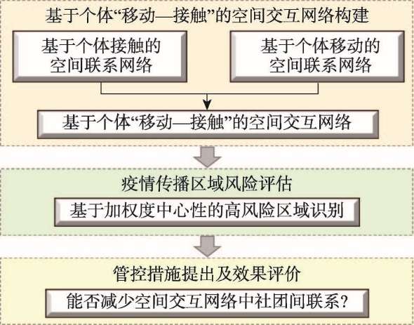
Transportation is a necessary way to realize human mobility. Spaces in transportations, such as buses and subways, are confined and crowded, which could induce a large volume of physical contact between passengers and thus promotes disease spread between areas with no human connection. Mobility and physical contact are widely regarded as two critical components in disease spread over space. However, current studies only considered a single aspect, human mobility or physical contact, in identifying high-risk areas of airborne disease. Without comprehensive consideration of human mobility and physical contact, health planners may misidentify areas with a high risk of airborne disease and design less-effective interventions. To fill the gaps, this study first proposed a theoretical framework that comprehensively considers human movement and physical contact during movement to construct a "movement-contact". Using public transit system in Beijing, we built "movement-contact" network with the Thiessen polygon centered by bus station as the node and the number of individuals moved or contacted as weight. Then, the weighted degree centrality of each node was calculated. Further, the K-shell decomposition algorithm was used to divide the importance degree of each node, thereby extracting the nodes (areas) with a high risk of disease transmission. Accordingly, we offer some suggestions to control the spread of the disease. Communities, despite being the basic unit of human activity, are rarely used to evaluate the effectiveness of disease control measures. To fill the gap, the effectiveness of control measures was evaluated by comparing the modularity of community structure before and after taking control measures. The results showed that there were three types of high-risk areas. The first type is the intercity transportation hubs, such as Beijing Capital International Airport, Beijing South Railway Station, and Beijing West Railway Station. The second type is some residential areas, e.g. Qinghe, Shahe, and Anhuiqiao. The third type is the business centers represented by Wangjing, Sanlitun, and Guomao. Based on the findings, this study suggests stopping bus services in high-risk areas to impede the spread of disease. After taking control measures, the modularity of the community structure reduced significantly. This study is of great significance for identifying high-risk areas of airborne disease, developing prevention measures for disease transmission, and evaluating the effectiveness of control measures. It provides some suggestions to prevent the spread of disease in a timely manner under the promise of guaranteeing the normal life of residents.
It is an essential way to ensure that health and equity could be enjoyed effectively through a balanced system of public health services. The layout of medical facilities, population distribution, and construction land distribution are highly correlated to public health services equalization. The research in this paper is based on spatial statistical analysis, the possibility-satisfiability model, and the coupling coordination degree model between public health service equalization, construction land distribution, and population distribution. Based on these methods, the spatiotemporal evolution regularity analysis is carried out on the public health services equalization in provinces of Hunan, Hubei, and Henan during 1980-2019. Furthermore, we examine the variation of the coupling coordination relationships between the triad of public health services equalization, population distribution, and construction land. The results show that: (1) the degree of public health services equalization fluctuates around the middle level (0.7-0.8), and it shows a general tendency of rising first and then falling. The average growth rate of public health services equalization in Hunan, Hubei, and Henan was -7.68%, -0.96%, and -2.11%, respectively. (2) The distribution of public health services shows obvious spatial clusters in Hunan, Hubei, and Henan. The high-high and low-low categories of spatial agglomeration indicated that an obvious polarizability effect exists in public health services distribution. Besides, public health services equalization in eight azimuth regions of each province is obviously different. This implies that the unbalanced and inadequate problem is prominent with the development of public health services equalization in the three provinces. (3) The degree of interactions and synchronous development between public health services, construction land, and population distribution is small. In general, the coordinated development state between the three is in the transition period from maladjustment to coordination. In order to deal with the complex man-land relationship at the new stage of China, we explore the spatiotemporal development pattern and the historical evolution characteristics of the public health services equalization, which can provide a policy-making basis for the rational configuration of public health resources and the improvement of public health services equalization.

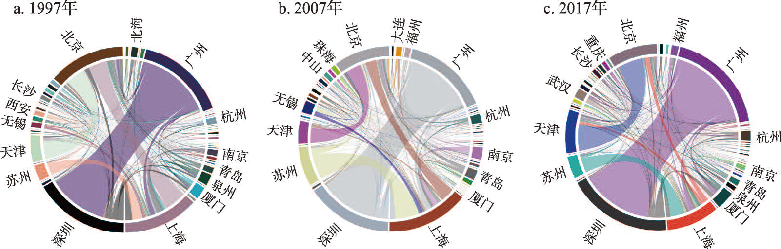
The high-quality development of inbound tourism is an important foundation for the high-quality development of China's tourism industry, and its inbound tourism city cooperation network has become a key support to achieving this goal. However, our current knowledge of the spatio-temporal characteristics of China's urban cooperation network of inbound tourism remains limited. This paper used economic development data of inbound tourism in 60 cities of China from 1997 to 2017, the revised gravity model, and social network analysis method. It first examines the intensity of China's inbound tourist city cooperation, and then systematically analyzes the spatiotemporal patterns of these networks. Finally, it applies the second assignment method to discuss the possible driving forces of these networks. The results show that: (1) These networks across the 60 cities have gradually increased in intensity. Simultaneously, a national-level network of tourism cooperation has emerged. The top five pairs of city groups participating in tourism cooperation are Guangzhou-Shenzhen, Beijing-Shanghai, Beijing-Tianjin, Shanghai-Suzhou, and Shanghai-Shenzhen. (2) With regard to overall network characteristics, network density is gradually increasing, overall network accessibility is improving, city "leader" status is declining, and the overall network balance is strengthening. There are significant differences between China's three major parts (eastern, central, and western regions): cities in the eastern region have the strongest cooperation, followed by cities in the central and western regions. (3) In terms of individual network characteristics, China's inbound tourist cities are divided into four categories: extroverted, cohesive, balanced, and isolated. Their power roles demonstrate a "core-periphery" pattern, showing the characteristics of core leaders, sub-core leaders, general collaborators, and marginal collaborators. (4) Geographical proximity, differences in tourism resources and reception capabilities, city-scale levels, and similarities in tourism-traffic conditions have a significant effect on the improvement of the network. Differences in foreign economic engagement and trade have a positive effect on urban-tourism cooperation in the central and western regions. However, these differences have a negative impact on eastern networks and the whole country. Our findings unravel the changes in China's inbound tourist city cooperation networks, and provide important reference for the optimization of the network.
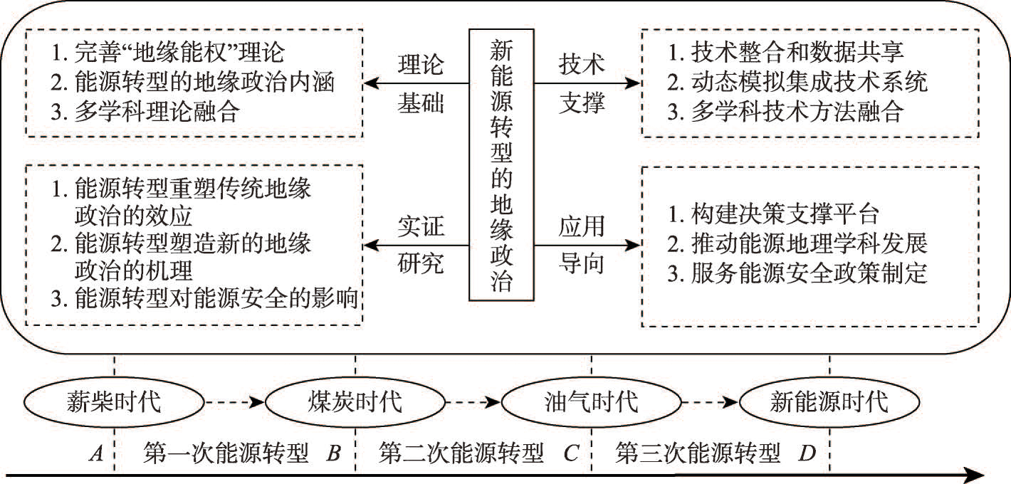
Under the background of global energy transition, the geopolitical problem of energy transition has increasingly become one of the frontiers and hot topics of world energy geography and politics. There are obvious differences in energy connotation, attributes and geopolitical characteristics in different stages. In the new energy era, energy geopolitics is more diversified, complex and comprehensive. This paper compares the geopolitical characteristics of energy in different stages, and combs the research process of new energy geopolitics. The research shows that the global energy transition will intensify the reconstruction of geopolitical pattern, change the relationship between geopolitical security and conflict dominated by traditional energy security, change the role of different countries in global energy geopolitics, reshape the national energy relationship formed in the traditional oil and gas era, and highlight the impact of new energy technologies and key scarce materials on the geopolitics of energy transition, and cause energy network security problems. It is found that scholars of various disciplines have paid extensive attention to the geopolitics of energy transition. At present, there are many uncertainties about the geopolitical impact of energy transition, and there is still room for development and improvement in the theoretical framework, technical methods and research perspective. Looking forward to the future, the geopolitical research of energy transition urgently needs to strengthen the discipline theoretical research, promote the scientific and quantitative research of geopolitics of energy transition, and strengthen the application research of service discipline development and major national energy security decisions, explore the geographical effect of energy transitions on the reconstruction of traditional energy geopolitics, the mechanism of energy transition geopolitics and the impact of energy transition geopolitics on energy security. Meanwhile, geopolitical research on energy transformation should be carried out in close combination with international academic frontiers such as climate change, "carbon peak and carbon neutrality" goals, and global energy governance, so as to enrich the research perspective of world energy geography.
Since the release of "Vision and Actions on jointly building Silk Road Economic Belt and 21st-Century Maritime Silk Road" in 2015, the Maritime Silk Road container shipping network has experienced rapid development and significant changes along with the construction of the Belt and Road economic community. To explore changes in the vulnerability of the Maritime Silk Road container shipping network under intentional attacks, this study proposed an identification method for the critical point of collapse of the container shipping network based on geospatial connection changes and the network fragmentation process under such attacks. In addition, a quantification method is developed for the change trend and degree of vulnerability of the container shipping network. The network was constructed using statistical data of ports and routes of the Maritime Silk Road in 2015 and 2019. The results show that the intentional attack tolerances of the networks in 2015 and 2019 were 4.21% and 5.51%, respectively, indicating that the Maritime Silk Road container shipping network in 2019 was stronger than that in 2015, with a relative change rate of 30.88%. The driving mechanisms for the vulnerability changes in the Maritime Silk Road container shipping network mainly included the diminished differentiation in the structure of the port hierarchy, the increasing completion of the backup mechanism of key ports, and the closer container shipping links of East and Southeast Asia with other regions. Corresponding countermeasures and suggestions are proposed for continuously guaranteeing the interconnection of container shipping between China and countries (regions) along the Maritime Silk Road. The results of this study have important theoretical significance and practical value for revealing the vulnerability changes of the Maritime Silk Road container shipping network and its driving mechanisms and influencing factors, as well as for ensuring the continuous interconnection of the network. The analysis method presented in this paper can provide a reference for related research on vulnerability changes in other transportation networks.
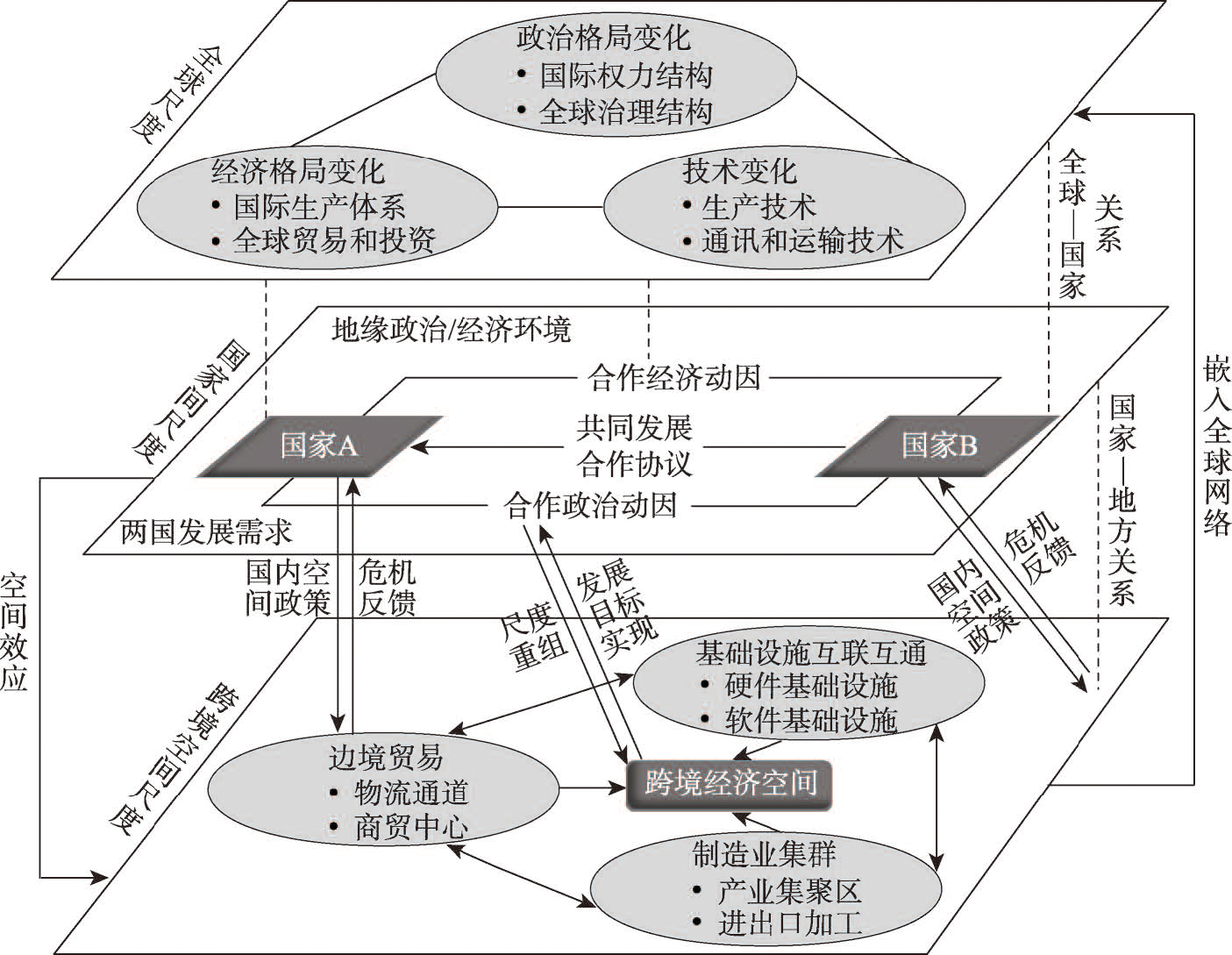
Since China's Belt and Road Initiative (BRI) in 2013, transborder economic cooperation has received increasing attentions. The existing studies have focused on the geopolitical environments and the contents of cooperation, but few have examined the historical evolution of the spatial organization models of transborder economic cooperation. This study aims to fill the gap to explore the evolutionary process of the spatial organization models of transborder economic cooperation between China and Russia. Taking Heilongjiang Province of China and the Far East of Russia as a case, we proposed a novel framework for understanding trans-border economic cooperation from multi-scalar perspective, based on Brenner's New Nation Space theory. Our results reveal that the spatial organization pattern of China-Russia trans-border economic cooperation since the 1990s has experienced three evolutionary stages: transborder trade-based stage in the 1990s, overseas industrial park-based stage between 2000 and 2013, and transport corridor-oriented stage from 2013 to present. After the borders in Heilongjiang were gradually opened in the late 1980s, Sino-Russian transborder trades entered into a rapid development stage. After the mid-1990s, disputes and crises emerged in the transborder economic cooperation pattern propelled by border trade, which led to a new round of reshaped cooperation pattern of industrial parks established by Chinese enterprises. After 2013, the new mode of transportation corridor-oriented cooperation emerged because of the multi-scalar and multi-dimensional reorganization in order to respond to the crisis of the old pattern. The evolution suggests that there is a certain degree of historical dependence between the new and old patterns. This study extends the theory of New Nation Space and provides scientific basis for promoting high-quality development of transborder cooperation between China and Russia.
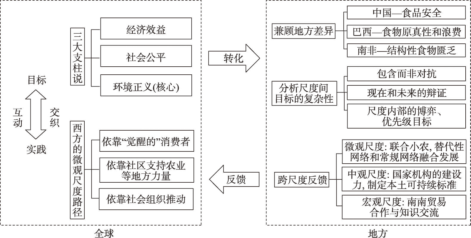
The industrialization of agriculture and the "de-localization" of production patterns, misty distribution processes, and inflated consumption desires have led to a continuous crisis in food systems, and the sustainability of food systems has become a challenge at the global scale. Current research on the sustainable food systems is confronted with the problem of scale. The sustainability goals at the global scale are ambitious and inclusive, but the differences at the local scale are not taken into account. In terms of pathways, the practices of Western countries have led to a "scalar trap", where the microscopic scales such as communities are overemphasized to the exclusion of the potential role of other scales. Based on perspectives of scale, this study analyzes the "sustainability" constructs of various actors within the food systems of China, Brazil, and South Africa, and proposes a scale logic for the transformation of food system sustainability goals and empirical feedback. The study finds that: (1) The transformation of goals from global to local scale needs to take into account local differences. China, Brazil, and South Africa generate their own priority sustainability goals, which address food safety, food authenticity and food waste, and structural food scarcity, respectively. These goals are fraught with tensions and trade-offs and cannot be equivalently substituted. (2) Empirical feedback from the local to the global scale requires a shift away from the micro-scale superiority conferred by Western experience and toward cross-scale practices. The sustainable practice pathways in developing countries lie in bringing into play the dynamics of various actors in the food system and mobilizing resources to form effective networks of action across scales. (3) The experience of developing countries suggests that scale is a method in itself, not an end in itself, and that each specific sustainability goal is matched with an appropriate scale approach, and that there is a need for research to suggest ways to tap into diverse and differentiated sustainability models so as to fully promote sustainable development of local and global food systems.
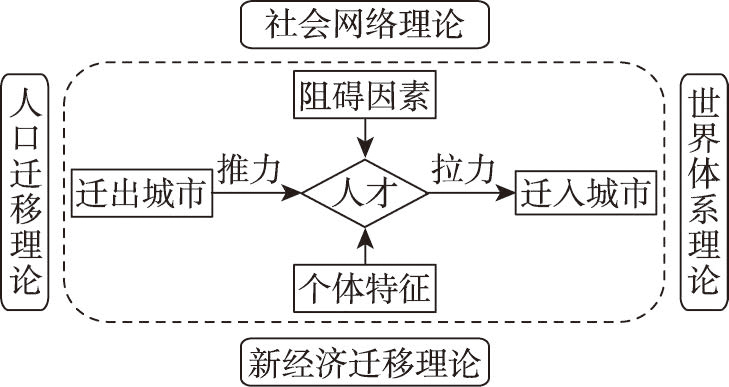
As an important innovation resource, top world talents play a vital role in promoting regional innovation and competitiveness. Among all kinds of top world talents, highly cited scientists, whose achievements are highly original and subversive, form a crucial scientific and technological force determining the direction of future scientific development. The geographical structure and influencing factors of their immigration are important and are being investigated within the field of geography. According to previous studies, different population types have different location choices. Despite existing research on the mobility of the general labor force, the question of which model is suitable for the movement of highly cited scientists has not yet been settled. This paper integrates the world city theory into population mobility studies and investigates the mobility of highly cited Chinese scientists. We compiled the list of highly cited Chinese scientists based on the 2014-2015 global list of highly cited scientists on the Web of Science as well as a background and resume information search. We proceeded with the research in the following ways: We firstly constructed a composite talent migration theory on the basis of the population migration theory in order to explore which factors affect scientists' location choice in their working periods; we secondly described their mobility characteristics during their education and working periods, including a detailed analysis of domestic and transnational migration during the working period; we thirdly applied the Heckman two-stage selection model to explore the applicability of compound population migration theory in high-end talent flow; and we finally conducted a classification study from the perspective of domestic/transnational mobility of talents and used the Probit regression model to explore the influencing factors of scientists' willingness to return to China or go abroad along with the factors that influence scientists' domestic mobility. The main conclusions can be drawn as follows: (1) The talent flow trajectory of highly cited Chinese scientists showed that the target places of scientists are mainly core cities (measured by degree centrality) at home and abroad. (2) The transnational flow direction of highly cited Chinese scientists in the working stage is mainly from American cities to Chinese cities. (3) The composite population migration model has an obvious role in explaining the location selection of highly cited Chinese scientists in their working stage. Scientists mainly choose to move to core cities and their willingness to move is largely affected by their individual characteristics. (4) The factors influencing the choice of movement of highly cited Chinese scientists at home and abroad are different. The domestic mobility of scientists is limited by geographical distance, and highly cited Chinese scientists' transnational movement is mainly affected by the pull of the destination cities. We demonstrated that the composite population migration model was more suitable for the study of talents' movement inside the region (globally or within a country), while the push-pull model was more suitable for transnational movement.