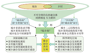
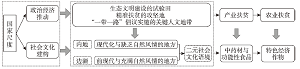
Urban and rural areas are always an inseparable organic integration, and the high-quality new urbanization is the process of urban-rural integration and rural revitalization. "urban disease" and "rural disease" are connected with each other, and are the causes of each other, which are known as "urban and rural diseases". The radical cure of "urban disease" and "rural disease" requires rural revitalization and new urbanization. Based on the review of the research on urban-rural integration development at home and abroad, this study analyzes the pathological roots and opposition pattern of urban and rural areas from the theoretical level, explores the main controlling factors, driving mechanism, sustainability and four-stage regularity of urban-rural integration development, constructs the measurement test system of urban-rural integration development, and puts forward the triangular model of urban-rural multi-integration development. It is known that the urban-rural integration development in China is in the high integration stage of more towns and less villages in the late urbanization, and will enter the deep integration stage of more towns and less villages, namely the final stage of urbanization. This study explores the policy evolution path of urban-rural integration development in China since the founding of the People's Republic of China in 1949. China has generally experienced the policy evolution process from urban-rural coordinated development to the integration of urban-rural development and then to urban-rural integration development, and played an important guiding role in promoting new urbanization and rural revitalization. From the path level, it is suggested that the Central Urban and Rural Work Conference should be jointly convened, the National Urban-Rural Integration Development Plan should be jointly compiled, and the strategy of deep integration of urban-rural development should be implemented. The new urbanization and rural revitalization should be used as two different means to solve urban and rural diseases and improve the quality of urban and rural development. The theory and method of urban-rural integration development should be innovated, and the evaluation system should be constructed to quantitatively evaluate the depth of urban-rural integration development and build beautiful cities and beautiful villages. We should promote the development of new urbanization and rural revitalization in the direction of high synchronization, deep integration and co-prosperity, as well as improve the quality of urban and rural development and realize urban and rural modernization in a comprehensive way.
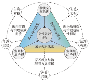
The rural vitalization in the new era and space development and utilization are closely related. It is meaningful to construct a theoretical system and practical path of rural vitalization based on rural spatial governance. Based on the deconstruction framework of "demand→effect→path→strategy", this paper discusses the internal logic relationship between rural vitalization and spatial governance. The results show the following: (1) The reconstruction of rural value is the key to ensure the realization of rural vitalization; rural spatial governance can be a good way to realize the rights allocation and effective control of rural space; rural spatial governance includes material spatial governance, organization spatial governance, and ownership spatial governance; through spatial governance, the structure and function of physical space can be reconstructed, the organization relationship can be reorganized, and the value distribution can be reshaped. (2) The effect of spatial governance on rural vitalization is presented from the optimization of the urban-rural interaction, as well as the stimulation and strengthening of rural endogenous power, and the capabilities of grassroots organizations. (3) Rural spatial governance is an effective path to implement rural vitalization by promoting the urban-rural integration development, activating rural endogenous development, and ensuring the organizations mechanism. (4) The rural spatial governance system combines "top-down" and "bottom-up" forms to implement rational allocation of spatial development power. The channels, capabilities, and effects of multiple subjects participating in spatial governance will promote the realization of space development and the establishment of a system with equitable rights and interests. The "right-sharing" spatial governance can implement the rural revitalization strategy in urban-rural sharing, subject and regional sharing. In summary, the research will provide references for improving the scientific system of rural spatial governance and implementing the rural revitalization strategy.
The progress of human settlement research in geography and architecture is reviewed from the perspective of a theory tree. First, an exploration of the research skeleton indicates that the two disciplines have the same tree roots, that is, nine research subjects and eight research scales; the same tree trunks, that is, nine research subjects and eight research scales; and the same tree branches, that is, 33 research fields; however, they have different tree leaves, in other words, there are different quantities of research achievements in each research field. Second, a comparison of the characteristics of the research achievements indicates that the research achievements in the two disciplines differ significantly. For six secondary subjects (e.g., suitability), there are abundant research achievements in geography, but few in architecture. For six secondary subjects (e.g., planning) and the architectural scale, there are abundant research achievements in architecture, but few in geography. For twelve secondary subjects (e.g., spatial pattern) and six scales (e.g., city), in both disciplines, there are abundant research achievements, but the focus points of their research achievements differ. For the behavior of the secondary subject and global scale, in both disciplines, there are few research achievements, but the focus points of their research achievements differ. Finally, the generative logic of the difference in achievements between the two disciplines is analyzed, and future interdisciplinary research pathways are proposed. The logical starting point for different achievements is due to different discipline categories. The logical chain of the difference in achievements is the transmission mechanism of "discipline categories-discipline characteristics-researchers-research preferences-research paradigms-research achievements". Among them, the difference between research paradigms is an important link in the chain. In the future, human settlement research paradigms should be improved, including extending the research framework, developing research subjects, planning research scales, applying multisource data, and using mixed research methods. Moreover, there should be a response to the needs of real-world development in terms of globalization, beautiful human settlements, emergencies, and interdisciplinary cooperation.
The formulation and development of geopolitical theory have profoundly imprinted the influence of maps. In the history of the development of geopolitics, different map projections not only serve different thinkers' theoretical formulation, but also penetrate into the dynamic revisions of their own theories in different periods. How exactly do map projections participate in the construction of geopolitical theories? Based on existing cartographic research of geopolitics, this article discusses the relationship between map projection and the construction of geopolitical theory by interpreting and communicating the spatial analysis with the discourse analysis in map functions, from these two basic attributes of maps, namely spatiality and textuality. On the one hand, the framework of mental map after a map projection deformation and abstraction provides the spatial support for constructing a geopolitical theory; on the other hand, the map projection gathers abundant layers of textuality through map distortion in complex contexts. Under the intertextualities (complementary narratives) among all layers of textuality in map projection, new map discourse can be generated and infiltrate into the mental map, which promotes the generation of core concepts and the construction of logical relations of geopolitical theory in a figurative way. Considering the influence of Mackinder's map view, in this paper, the explanatory power of the relationship framework is verified through making a perspective analysis from map projections on all stages (1904, 1919, 1943) of the change of Mackinder's Heartland geopolitical thought. This reveals the potential applicability of the analysis framework in other geopolitical theories researches. We are looking forward to the construction of China's geopolitical theory based on the intertextuality of the innovation of map projections in the complex contexts interweaved with the world experiencing a level of change unseen in a century and the strategic goal of achieving national rejuvenation and so on.
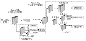
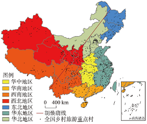
The research on the distribution of rural buildings is one of the essential works of rural revitalization in China. Adopting Mask R-CNN deep learning framework and collecting sub-meter remote sensing image, this research successfully trains remote sensing interpretation models suitable for local rural buildings based on the human geographical characteristics in each province. A multi-scale database of Chinese rural building based on single rural building has been created, including 154 million agricultural houses in 1484 counties with a total construction area of 29.82 billion square meters. Based on the database, this paper analyzes the distribution characteristics of rural buildings at the county, town and settlement scales. At the county scale, the density of rural buildings showed a distribution pattern of 'dense in the east and sparse in the west', consistent with the population distribution pattern revealed by Hu Huanyong Line. At the town scale, the density of rural buildings increases from west to east with the descent of three terrain steps, and the spatial distribution tends to be balanced, corresponding to the agricultural productivities and topography in the agricultural zones. At the settlement scale, the distribution of rural buildings shows the pattern of 'dense in the south and sparse in the north', consistent to the climate condition, topography and arable land per capita. The construction of China's rural building spatial database could lay a solid foundation for the "computational" rural research in the future.
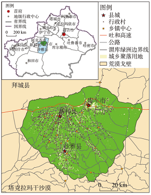
With the proposal and implementation of the Rural Revitalization Strategy, the relationship between urban and rural areas has entered a new period of integrated development. It is of great practical significance to clarify the evolution process and current characteristics of the typical regional urban-rural settlement scale system and explore its spatial reconstruction and optimization path for the realization of agricultural and rural modernization. Taking the Ugan-Kuqa River Delta Oasis (hereinafter referred to as "Weiku Oasis") on the northern margin of the Tarim Basin in Xinjiang as an example, this paper used land-use data from 2009 to 2018, GIS spatial analysis and rank-size rules to describe the characteristics of the urban-rural settlement scale system, and discussed the urban-rural settlement scale system in the study area according to the theoretical connotation of the multilevel goal of the rural revitalization spatial reconstruction mode and optimization path. The results showed that (1) in the process of the construction of the urban and rural system, the leading role of cities and towns was weak, the overall expansion of the urban-rural settlement scale was fast, the contrast between the urban and rural population and settlement growth was large, and the maladjustment of the rural man-land relationship was obvious. (2) The overall distribution of the urban and rural settlement scale obeyed the rank-size rule, the phenomenon of a "wagging tail" of sporadic settlements was increasing, the spatial disorder of expansion was obvious, and the spatial distribution of urban and rural settlements presented the characteristics of agglomeration; however, the spatial agglomeration trend toward the central town was not obvious. (3) The first measure of spatial reconstruction of the urban and rural settlement scale system was to renovate scattered patches. Three optimization targets were set for typical sample areas, and the path of spatial reconstruction was analyzed logically. Five kinds of renovation directions were proposed. Based on the multilevel goal of rural revitalization, it is of great practical significance to construct a spatial reconstruction scheme with land factor flow as the key variable to promote the structural optimization and functional coordination of the urban and rural settlement system in the Weiku Oasis and to realize rural revitalization.
Rural gentrification is a new path for rural transformation and revitalization under the background of two-way flow of urban and rural elements. This paper analyzes the evolution process, type and mechanism of rural gentrification based on actor-network theory (ANT) based on a diachronic field survey of rural gentrification in the Panyang River Basin of Bama County, Guangxi Zhuang Autonomous Region. The following results were obtained. (1) The evolution of rural gentrification is a dynamic actor-network jointly established by human and non-human actors, "grass-roots" actors and institutional actors. The evolution of rural gentrification has experienced a transition from initial to development stage, which has brought a series of changes. The key actors are replaced from the "amenity immigrants" pioneer and local elites to local governments and investment developers, while the OPP (obligatory passage point) has changed from "developing 'migratory bird' tourism and building a longevity village" to "developing comprehensive health industry and building a global longevity town". The path succession of rural gentrification changes from "grass-roots" gentrification to institutional gentrification with the replacement of key actors from "amenity immigrants" pioneers, and the rural gentrified industry has changed from receiving amenity migrants and developing tourism to the integrated development of comprehensive health industry. The gentrification type has evolved from "amenity immigration oriented" to "tourism oriented" and "real estate oriented", and finally formed a mixed rural gentrification pattern of "multiple types in one place". (2) Factors such as the replacement of key actors along with their roles and functions, the path succession of rural gentrification, the replacement and integrated development of leading industry, China's macro rural development system, as well as the regional natural and cultural environment, which jointly affect the stage succession and type symbiosis of rural gentrification. The replacement of key actors along with their roles and functions transformation dominates the stage succession of rural gentrification, while the path succession of rural gentrification as well as the replacement and integrated development of leading industry, which jointly promotes the evolution type of rural gentrification, is the general mechanism of rural gentrification evolution. At present, China's rural macro development strategy (Beautiful Countryside Construction, Targeted Poverty Alleviation and Rural Revitalization) and basic institutional arrangements (rural land collective ownership, homestead system, and regional development dominated by the local government) as well as the regional natural and cultural environment (unique healthy geographical environment, and "migratory immigrants" healthy geographical dependence, combined with the actors' power balance under the comprehensive action comprised by "Bama complex", the Zhuang clan power and the rural nostalgia) shapes the symbiotic characteristics of evolution type, which is the regional mechanism of rural gentrification evolution. (3) Actor-network theory (ANT) is a conducive method to show the stage succession context and symbiotic characteristics of evolution type, and reveal the general mechanism and regional mechanism of rural gentrification evolution.

Agricultural poverty alleviation is one of the most critical and important research contents in rural development and poverty alleviation. The mountainous areas in Southwest China have unique natural ecology and social culture, classic practice of Chinese traditional human-earth interaction, and it is also a place to observe the human-earth relationship transformation under the national development intervention. Taking Maca planting and Pu'er tea production as examples, this paper analyzes and traces the implementation of the agricultural poverty alleviation projections, and presents and compares the development effects of these two projections on typical mountainous villages. The results show that: First, agricultural poverty alleviation projects need to be embedded into the national socio-cultural context and politico-economic governance framework. Various kinds of cash crops are incorporated in the agricultural poverty alleviation projects. This benefits from China's geopolitical strategy, the socio-cultural "centre-periphery" differentiation, and the practices of the complex interaction among multiple actors in Yunnan Province. Second, agricultural poverty alleviation projects have enabled mountainous villages to attract investment and transform land use types, thereby achieving capital accumulation and cultural reconstruction. Local farmers have changed from passive recipients of market competition to active market players. Maca planting and Pu'er tea production have irrevocably tied the natural environment in Yunnan and the life worlds of local people to the commodity economy. Third, in agricultural poverty alleviation, the political logic and market logic represented by "poverty alleviation" and "agriculture industry" are not contradictory and restrictive. The two have been coordinated and compatible in Chinese rural development. However, it is worth pondering that we need to guard against fluctuations in farmers' livelihoods caused by the rise and fall of cash crops in the implementation of agricultural poverty alleviation projects. The research provides a new geographical perspective and reflection for the industrial poverty alleviation research, and provides policy reference for the frontier of southwest China to achieve rural revitalization based on agricultural economy.
The key villages of rural tourism are typical demonstrations for promoting the high-quality development of rural tourism, which are of great significance for optimizing rural tourism supply and leading rural tourism development. The article analyzes the spatial distribution pattern and structural characteristics of 1000 key villages of rural tourism nationwide by using Nearest Neighbor Index and Kernel Density Estimation. The study further reveals spatial differentiation of the key villages of rural tourism. The main factors affecting spatial distribution of the key villages of rural tourism are analyzed by using Multiple Linear Regression, Vector Buffer Analysis and Geographic Detectors. The conclusions can be drawn as follows. Firstly, there are more key villages of rural tourism in the eastern region than in the western region of China. The inter-provincial spatial density stratification feature is obvious and the spatial distribution pattern of double core-ring core cluster-ribbon zone is unique. Secondly, the spatial distribution of key villages of rural tourism has significant positive spatial correlation. The key villages of rural tourism are spatially dispersed in cold spots and concentrated in hot spots. Thirdly, kernel density estimation shows that villages of agricultural production type have high spatial distribution density, while the others have low density. Fourthly, the spatial distribution pattern is the result of five factors: natural ecology, social economy, transportation facilities, scenic resources and policy environment. Gross domestic product per capita and household consumption expenditure have a significant positive impact, while the distance from the tourist market and the distance from transportation access are negative influencing factors. Fifthly, the driving factors for the spatial distribution of various types of villages are different and closely related to the village resource endowment and development characteristics.
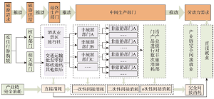
The rapid development of tourism industry has a great effect not only on direct employment, but also on indirect employment in other industries. Combined with tourism stripping coefficient and input-output analysis method, this paper constructs a measurement model of tourism industry that drives indirect employment. Based on this, the Dagum Gini coefficient decomposition method is used to analyze the evolution of spatio-temporal differences in the driving capacity of tourism industry on indirect employment. Based on the panel data of 31 provinces (autonomous regions and municipalities, hereafter provinces) in China, an empirical calculation is performed in this paper to show the capacity of tourism industry in driving indirect employment and its spatio-temporal differences. The research results are presented as follows: Firstly, the population of indirect employment driven by tourism industry surged from 26.846 million in 2000 to 48.949 million in 2019, which enhanced the driving capacity of tourism industry on indirect employment. Secondly, there were significant differences in the driving capacity between provinces. In terms of spatial distribution, the driving capacity of tourism industry on indirect employment decreased in a descending order (namely the eastern > the central > the western region). As for temporal distribution, such a driving capacity effectively broken through the blockade of Hu Huanyong Line. However, the regions where the tourism industry had strong driving capacity on indirect employment were still concentrated to the southeast of the Hu Huanyong Line. Lastly, there were striking differences in the role of tourism in driving indirect employment in different industries. The tourism industry has the most prominent driving capacity on indirect employment in such industries as farming, forestry, animal husbandry, fishery and manufacturing. According to the internal comparison of the tourism industry, the driving capacity of tourism transportation, warehousing and postal communications, tourism accommodation and catering industry is in the leading position. The overall gap in the driving capacity of tourism on indirect employment in China is convergent, which mainly results from the inter-regional gap.
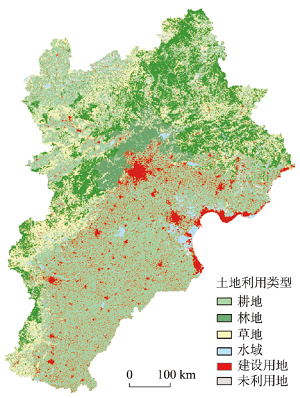
This study analyzed the spatio-temporal variations of surface CO2 concentration at the 10 km×10 km grid level over the Beijing-Tianjin-Hebei (BTH) region during 2000-2018 and further clarified the dynamics of regional land uses affecting spatial heterogeneity of surface CO2 concentration based on the Gaussian diffusion equation and the spatial Ramsey model. The results showed that surface CO2 concentration in the BTH region was closely related to land use types. The high-value areas of surface CO2 concentration were mainly concentrated in economically developed and rapidly urbanized areas during 2000-2018. The spatio-temporal differences of land use intensity and efficiency provided potential power for surface CO2 concentration diffusion. The surface CO2 emission and diffusion in the BTH region had obvious spatial heterogeneity, presenting that the closer the area was to the high-value area of CO2 emission, the higher the corresponding CO2 concentration was, and it decreased gradually with the elapse of time and spatial expansion. Moreover, with the adjustment of land use structure, optimization of land use spatial pattern, and improvement of land use efficiency in the BTH region, the increase rate of CO2 emissions intensity declined significantly and the differences of the increase rate among regions narrowed gradually at the same time. Industrial transformation and development, land use spatial pattern optimization, and land use efficiency improvement effectively restrained the increase of surface CO2 emission intensity in the BTH region, and promoted the connotative growth and high-quality development of the region.
Nowadays, urban agglomerations are increasingly evolving into multi-scale, interregional complex systems. Therefore, it is necessary to apply a multi-fractal method to analyze the global and local properties of an urban agglomeration. Based on the NPP-VIIRS nighttime light data in 2018, this paper calculates the multi-fractal spectrum of urban agglomeration in the middle reaches of the Yangtze River (MRYR) and its four sub-agglomerations, and then analyzes their multi-fractal properties from the perspective of scale. The main results are as follows: (1) The nighttime light capacity dimensions show that there exists a double-scale phenomenon in the whole study region and its four sub-agglomerations. (2) When q < -5.5, the spectral curves of global fractal dimension surpass the upper limit of fractal dimension; when q > 0, the nighttime light fractal dimensions of the Wuhan and Changsha-Zhuzhou-Xiangtan (Chang-Zhu-Tan) sub-agglomerations are obviously higher. (3) The spectral curves of local fractal dimension of three sub-agglomerations of Wuhan, Poyang Lake, Chang-Zhu-Tan and Yichang-Jingzhou-Jingmen show that the peaks of the f (α) curves incline to the right, and the right ends of the curves are higher than the left ends. According to the above results, we can draw some conclusions: (1) The regional integration level of the whole study area was relatively low. (2) There was a differentiated spatial structure in different scales and regions, characterized as multiscale and complex features. (3) The whole urban agglomeration and its four sub-agglomerations tend to develop in a centralized manner. From the perspective of multi-scale interaction, this study proves the multi-fractal model is competent for detecting the complex spatial structure and the underlying problems of mega-urban agglomeration. The multi-fractal model has the potential for further theoretical exploration and practical analysis.
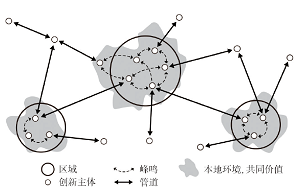
With the rise of the knowledge economy and network society, knowledge collaboration networks have become vital to understanding innovation processes. There are two types of collaboration patterns within interurban knowledge collaboration networks, namely "local buzz" and "global pipelines". This study discusses the characteristics of intraregional and interregional collaboration linkages and their impacts on the knowledge output based on the logic and hypotheses of the "buzz-and-pipelines" model. First, the study proposes novel measures of buzz and pipelines. Second, the study constructs knowledge collaboration networks among 215 cities at prefecture-level and above across 20 urban agglomerations in China based on the co-publication data drawn from the Web of Science. An investigation of the evolution paths and combination patterns of buzz and pipelines in the networks identifies different collaboration patterns among Chinese cities. Finally, the impacts of buzz and pipelines on cities' scientific output are examined. The results show that: (1) The evolution of buzz and pipelines in China's interurban collaboration networks presents cumulative and self-reinforced path dependences. (2) Chinese cities can be categorized into four types, namely "networked", "outward-oriented", "inward-oriented" and "isolated" cities. Different kinds of cities present distinct features in terms of collaboration trajectories and knowledge production. (3) There is an inverted U-shaped relation between intraregional linkages and the knowledge output performance of Chinese cities, whereas the relation between interregional linkages and knowledge output is significantly positive. The relationship between intraregional and interregional linkages is complementary in facilitating cities' knowledge production processes.
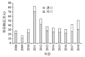
Since the Sino-U.S. trade friction to the "cold war of science and technology", rare earth, the "lifeline of high technology", has increasingly become the key point of the international games. Under the circumstances, it is of great significance to clarify the trend of China's rare earth trade and its role in the international rare earth market, to generally optimize China's resource security pattern and maintain the independence of science and technology in the long term. This paper uses the data from 2008 to 2018, including China's rare earth import and export trade data, the relevant national social, economic and political indicators, and the UN voting data. Then it discusses the spatial pattern evolution, interdependence evolution and main influence mechanism of China's rare earth products foreign trade, with the help of interdependence index, geographical affinity, GIS space technology and negative binomial panel regression. The results show that: (1) China's rare earth trade fluctuates greatly, and the export volume is much larger than the import volume, showing an "up-down-up" trend as a whole. (2) China's import market is highly concentrated and the path-dependence effect is enhanced, while the export market is gradually diversified and the path dependence is weakened. China mainly exports middle stream and downstream products with high added value and imports upstream mineral products with low added value. (3) China has strengthened its dominant position in the global rare earth trade interdependence pattern. The interdependence relationship between China and its most friendly countries has been strengthened, while that between China and the United States, Canada, Australia and other differentiated countries has been weakened. (4) The characteristics of countries, subject attribute proximity between countries and China's trade policy and trade environment have an important impact on China's rare earth import and export trade.
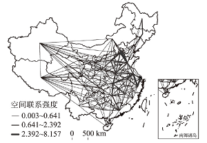
Existing research has generally focused on the resource endowments and functional attributes of grain production units, with limited studies on the externalities arising from the interactions of economic agents. Therefore, this paper focuses on the impact of network externalities on grain production efficiency based on the spatial gravity model and takes network externalities as a logical starting point to further explore the network enhancement path and the comprehensive positioning and potential of each spatial unit in the overall network. The results show that the spatial spillover effect of China's grain production network is significant and has an obvious promotional effect on grain production efficiency, which is, in essence, the expansion of the idea of scale management in the spatial dimension, consistent with the law of near-driving and far-radiation, and the interconnection of transportation infrastructure and population movement are the main paths to realize the spatial spillover of the network. Additionally, there are four types of potential nodes in the overall network: core control type, local core type, potential type, and edge type. In the future, it is necessary to give full play to the radiation-driven role of core-controlled nodes, strengthen the spatial interaction between the eastern and western regions of China, and realize the cross-regional flow and complementarity of agricultural resources and technologies.
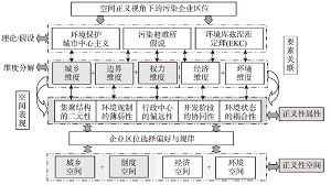
Spatial governance and location optimization of polluting enterprises plays an important role in improving risk resistance of underdeveloped regions. From the perspective of spatial justice, a location analytical framework of 5 dimensions - 5 attributes - 4 spaces is constructed to explore the pattern characteristics, and location rules of polluting enterprises in the Loess Plateau region, a typical inland underdeveloped area of China. Furthermore, this paper attempts to discuss the justice of location selection of polluting enterprises in underdeveloped areas from a dialectical point of view. We use methods of nearest neighbor index, kernel density estimation, location remoteness, inconsistency index and bivariate spatial autocorrelation to systematically analyze spatial characteristics of polluting enterprises which were subject to intensive monitoring and control of the whole country in 2017. The major findings can be summarized into five aspects. (1) Analyses on the five dimensions of urban-rural, boundary, power, economy and environmental identify that the current distribution of polluting enterprises in the Loess Plateau region is in a low-level equilibrium and has a resource-dependence, characterized as the initial stage of regional development. (2) Polluting enterprises tend to be located in urban agglomerations with relatively mature urban network. However, some problems that face the polluting enterprises in developed areas such as imbalanced evolution and decentralization have emerged in the study region. (3) In the urban-rural space and institutional space, there is no obvious "urban centralism" or "pollution sanctuary" in environmental protection. In terms of the economical space, the study area is at the rising stage of the environmental Kuznets curve. The local economy has a non-exclusive dependence on polluting enterprises. As for the environmental space, air quality and number of polluting enterprises is at a low level of positive coupling, but there is no worsening trend in air quality due to clustering of polluting enterprises. (4) Polluting enterprises will gradually withdraw from provincial capitals and regional sub-centers. Therefore, second-tier cities in urban agglomerations with good industrial foundation and resource endowment will be the key areas of environmental governance and industrial admittance. (5) The spatial justice of subsistence and relocation of polluting enterprises in the development of underdeveloped areas is a dialectical topic. With its advantage in regional comprehensive analysis, the discipline of geography can provide scientific support to this research topic. Focusing on the Loess Plateau region in China, this study presents an analytical framework and quantitative measurement tools for future research on location selection of polluting enterprises, which are aimed to improve the spatial justice theory in the regional development of underdeveloped areas.
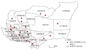
Spatial accessibility is an important index for measuring fairness in public services such as health care, education, and outdoor leisure. It has also been widely used in the layout planning of public facilities. However, the existing accessibility models cannot fully illustrate the direct relationship between service supply and demand, and thus, the accessibility indicators cannot be explained with explicit meanings. This article introduces a new method for measuring accessibility based on optimal supply and demand allocation, which is different from the supply-demand relationships in existing methods. Given the supply locations, the demand locations, their attributes, and the travel costs between them, the transportation problem model is used to allocate services to demands. The classical model can be easily solved with optimal total travel cost. Based on the model results, the spatial accessibility of services can be measured. The proposed method was tested on healthcare services in a district in Zhengzhou, Henan, China. There were 25 healthcare centres and 1333 residential communities in the study area. The instance model was effectively built by an open-source MIP solver in 2.2 seconds. The service area of each healthcare centre and the travel time from each community were obtained according to the modelling results. In addition, the coverage percentages with predefined service thresholds were calculated. The proposed method was also compared with popular methods, such as the two-step floating catchment area method (2SFCA), Gaussian 2SFCA, and gravity 2SFCA. Areas with poor healthcare services were identified by using the results from the three 2SFCA methods. However, the spatial variation in service accessibility might be very different when selecting different search thresholds and/or distance decay coefficients. The optimal supply-demand accessibility method (OSD) proposed in this study has advantages such as being parameter-free, easy to calculate, and easy to explain. The authors believe that the method has application potential to replace the existing methods in evaluating public services and facility planning.