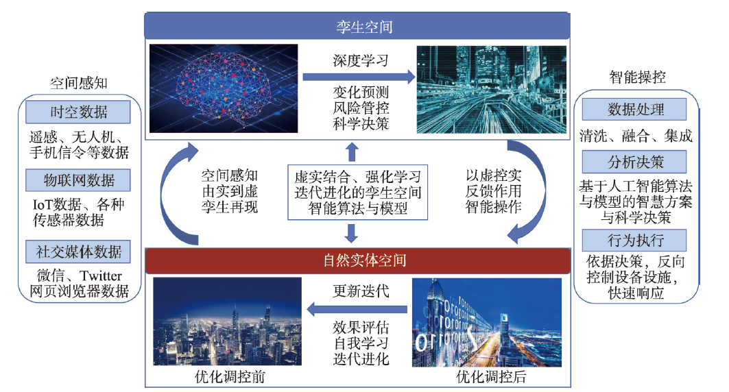
The past two years have witnessed an explosive growth of digital twin research and its increasing application in a wide range of fields and scales. This urgently calls for a methodological framework to guide and consolidate the research and application of digital twin in various fields and with different structures and scales. In this paper, we first summarized and analyzed the development patterns of digital twin research in various fields, and then coined a term "digital twin space" (with definition and characteristics) as a framework to generalize and consolidate digital twins of various scales. Taking digital twin city as an example, we briefly elaborated the application of twin space. Space, as the carrier of the research object or the research object itself in geography, consists of natural geographical space, social space, and cyberspace. These three types of spaces, however, have not been fully integrated in different branches of geography. In order to boost comprehensive geography research, we propose to reconstruct geographical space research by integrating the three types of geographical spaces with the twin space. Digital twin space can interact with the physical space bilaterally in real time and thus break the barriers among the three types of geographical spaces from inside, which further helps realize the tasks of simulating realities, predicting changes, and regulating processes in integrated geography research.
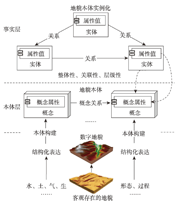
Digital elevation model (DEM) plays a fundamental role in the research of the earth system by expressing surface shape, understanding surface process, and revealing surface mechanism. DEM is widely used in geography and even in geological modeling and analysis. However, the existing DEM has its limitations in supporting the earth system research focused on geographical process and mechanism mining due to single attribute of the traditional DEM data model. Hence, establishing the value-added data model on the basis of traditional DEM is urgently necessary to serve digital elevation modeling and terrain analysis under the background of a new geomorphology research paradigm and earth observation technology. We construct a theoretical framework for value-added DEM that mainly includes concept, connotation, content and categories. The relationship between different types of value-added DEMs as well as the research significance and application category of this theoretical framework are also proposed. Different methods of value-added DEMs are listed below: (1) value-added methods of DEM space and time dimension that emphasize the integration of the ground and underground as well as coupling of time and space; (2) attribute-based value-added methods composed of materials (including underground, surface, and overground materials) and morphological properties; and (3) value-added methods of features and physical elements that consider geographical objects and landform features formed by natural processes and artificial effects. The digital terrace, slope, and watershed models are used as examples to illustrate application scenarios of the three value-added methods. This study aims to improve expression methods of DEM under the background of new surveying and mapping technologies by adding value to the DEM at three levels of dimensions, attributes, and elements, and support knowledge-driven digital geomorphological analysis in the era of big data.
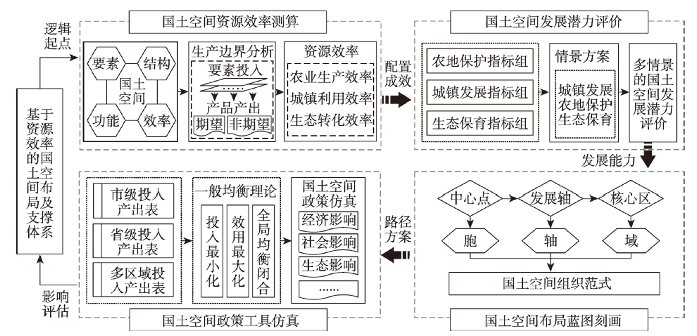
Forming a new territorial spatial pattern to rebalance the orientation of development and protection is one of the primary tasks in ecological civilization construction. The key to providing an effective territorial spatial pattern lies in realizing the rational allocation of urban space, agricultural space, and ecological space to support high-quality social and economic development as well as reducing the consumption of resources. Therefore, an in-depth understanding of the effects of resource efficiency on spatiotemporal patterns is a prerequisite for optimizing territorial space in a scientific manner. The technical framework in this paper analyses the resource efficiency of urban development, agricultural production, and ecological conservation as the logical starting point for the development of an optimal territorial spatial pattern. Firstly, the scenarios and index systems for the development and protections centered on resource efficiency are to be constructed; secondly, methods that reflect the preferences of decision-makers are to be designed, which will subsequently allow for the development capacity to be evaluated; thirdly, the blueprints of territorial space under different scenarios are to be created; and, finally, socioeconomic and ecological impacts of policy tools (blueprints) under different decision-making preferences are to be simulated based on comprehensive analysis tools. The research framework includes the following contents: the evaluation of the effectiveness of the allocation of territorial space from the perspective of resource efficiency, the refinement of specific laws for quantitatively portraying blueprints, and the construction of a global optimization strategy that weighs the pros and cons of various options for all parties involved. The research framework and its application can then be used as references for natural resources management and ecological civilization construction.
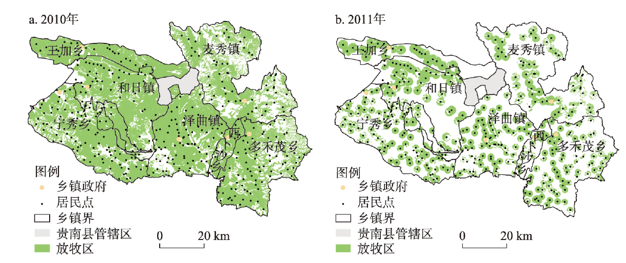
Spatialization of human activity intensity is the basis for examining regional differences of human activities and its change process, and it is also the scientific basis for accurately identifying the driving factors of land change and rationally regulating human activities. The current research on human activity intensity mostly uses mathematical methods to spatially assign indirect indicators, which lacks the reflection of the mechanism of human activity and also restricts the display of the spatial heterogeneity of human activity intensity. This paper took grazing activity on the Tibetan Plateau as the research object in an attempt to spatialize grazing intensity. First, based on grazing preferences and grassland management strategies, and from the perspective of grazing mechanism, we proposed a method to distinguish grazing areas and non-grazing areas; then, we used grazing density to measure the overall grazing pressure of grassland, and used grazing probability to describe the spatial difference of grazing pressure. In addition, we developed a spatial model of regional grazing intensity according to grazing density and grazing probability. As a case study, we used this model to spatialize grazing intensity of Zeku County, a typical pastoral area on the Tibetan Plateau, based on township-level animal husbandry data and basic physical geographic information. The results showed that the spatial model of grazing intensity we developed can reflect the spatial characteristics of grazing activity well, and the selection of direct indicators and objective assignment methods improve the accuracy of the spatialization results. It is also found that the results of this paper can more clearly reflected the spatial difference of grazing intensity within the county than the previous research results, and the change process of grazing intensity had a better coupling with the change of NDVI value over the same period. This paper could provide a useful reference for the research on spatialization methods of human activities.
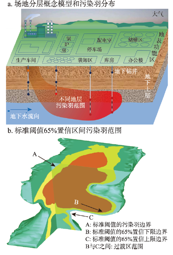
The precision remediation and redevelopment of contaminated sites are crucial for improving the living environment and constructing a beautiful China. Three-dimensional delineation of soil pollutants at contaminated sites is the basis and prerequisite for precise remediation and redevelopment. However, a contaminated site is a three-dimensional complex system coupling multiple spatial elements above- and under-ground. The complexity incurs significant uncertainties about the three-dimensional delineation of soil pollutants calculated by sparse borehole data and spatial statistical and inference models. In this study, we first systematically reviewed the objectives of three-dimensional delineation of fine soil pollutants, the sampling strategies for soil drilling, the commonly used models for delineating soil pollutants, and the relevant cases on applying these models at contaminated sites. We then summarized the effects of soil borehole data and three-dimensional models on the soil pollutants' delineation results from sparse skewed characteristics and non-stationary conditions, respectively. The present research status and related issues on correcting sparse skewed characteristics and non-stationary conditions were analyzed. Finally, based on the problems and challenges, we proposed the three-dimensional delineation of soil pollutants in the underground "black box" for future research from the following six priority areas: multi-scenarios, non-stationarity, non-linearity, multi-source data fusion, multiple model coupling, and the delineation of co-contaminated sites.
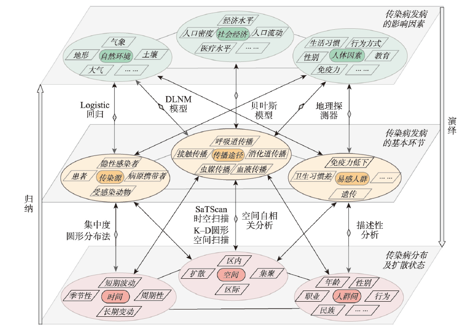
The Healthy China initiative is one of the important strategies in the new period of China. Hand, foot, and mouth disease (HFMD) is a global health threaten. It is a typical infectious disease with a wide and universal impact in China, especially to infants. This paper develops a theoretical framework for the study of infectious diseases from the health geography perspective. The framework used concentration and spatial analysis methods to analyze the spatio-temporal differentiation and evolution patterns of HFMD incidence in China from 2008 to 2017. Using spatial correlation analysis and geographic detection of 18 risk factors for the incidence of HFMD, we identified the main influencing factors and revealed the mechanism of the geographic distribution of HFMD. The results show that: (1) the theoretical framework of infectious disease research from the perspective of health geography includes three subsystems: the basic link of infectious disease, influencing factors, and the distribution and diffusion state of the infectious disease with mutual interaction and impact between and within the three subsystems. (2) From 2008 to 2017, the incidence rate of HFMD in China showed a fluctuating increase, with a two-year cycle. In addition, the incidence in the even years was higher than that in the odd years. The peaks of incidence are observed in late spring, early summer, late autumn, and early winter. (3) The incidence rate of HFMD from 2008 to 2010 did not reflect obvious characteristics of the spatial agglomeration. However, the incidence rate had a strong spatial autocorrelation from 2011 to 2017. Hotspots were mainly distributed in southern humid areas such as Guangdong, Guangxi, and Hainan. Moreover, the spots were evolving from north to south, and changing from small and scattered to large and concentrated spots. HFMD mainly occurred in three typical areas, namely, areas with hot and humid climates, economically underdeveloped areas with poor medical resources, and densely populated areas prone to clustered infections. (4) Twelve factors have passed the test of significance of correlation analysis and geographical detection. The explanatory power of the factors that positively affect the incidence rate are sorted as follows: AT > AP > RH > BP > PD > RND > PCG; factors that have negative correlation are sorted as follows: SD > WS > AQI > DEM > HBP. The interaction between AT and AP and other factors is the most obvious. This study provides an empirical basis for research into HFMD's health geography, pathology, and epidemiology, and important scientific support and policy reference for serving the strategy of Healthy China and epidemic control and prevention.
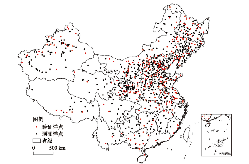
The soil temperature status is of great significance to climate change, the earth's material energy cycle, and the evolution of soil properties. However, there is currently a lack of research on the long-term sequence and spatial changes of soil temperature status on a national scale. Therefore, based on the soil temperature interpolation method and Geographic Weighted Regression (GWR) model, this paper used the observation data of 880 meteorological stations in China from 1951 to 2010 to study the characteristics of the spatio-temporal changes of soil temperature in China and its influencing factors. The results showed that: (1) The overall trend of soil temperature changes in China over the past 60 years increased in the northeast and decreased in a few areas in the southwest; (2) The soil temperature in China can be divided into cold soil temperature status (Northeast China, Qinghai-Tibet Plateau and eastern Inner Mongolia), temperate soil temperature status (southern Xinjiang, Inner Mongolia, southwestern Shanxi and Shandong) and thermal soil temperature status (central China, eastern China, southern China, and Yunnan, Guizhou and Sichuan in Southwest China); (3) Longitude, latitude and air temperature had good responses to and relationships with the soil temperature, of which air temperature was the most important influencing factor; 4) Over the past 60 years, there was a trend of warm soil regime migrating to the north (approximately 46.5 km) and cold soil regime to the south (approximately 43.4 km). The research results can provide a certain reference for in-depth research in related fields such as geography and soil science, and a theoretical basis for the study of soil systematic classification.
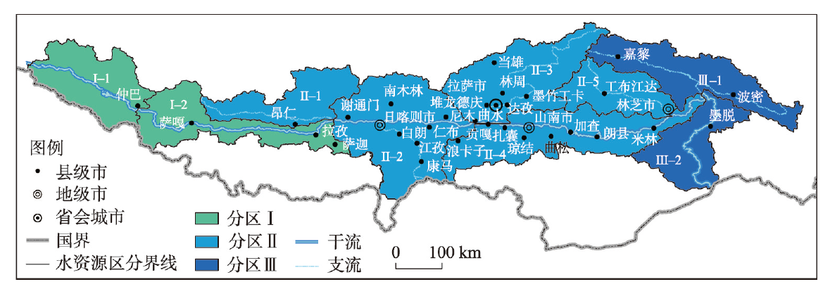
The Yarlung Zangbo river basin (YZRB) is sensitive to global climate change. The precipitation changes in the YZRB have a great impact on the evolutions of water system, ecosystem and mountain disaster system on the Qinghai-Tibet Plateau. In this study, we divided three water resources regions of the YZRB into nine subregions through hydrological analysis. Based on precipitation data within the YZRB from 1979 to 2018, we examined the spatio-temporal variations of precipitation at annual, wet and dry seasons, monthly scales, daily and hourly extreme precipitation in the study area and its nine subregions. We further discussed the correlation between precipitation and typical large-scale atmospheric circulation factors. The results showed that: (1) From 1979 to 2018, at the whole basin scale, precipitation at each time scale showed an overall upward trend. Among them, annual precipitation showed the largest increasing trend of 2.5 mm·a-1. Annual precipitation, dry and wet precipitation, and typical hourly scale extreme precipitation (Rx3hour and Rx12hour) increased significantly at the 95% confidence level. At the regional scale, the variation trend of precipitation at different time scales in each subregion showed more obvious inconsistencies. Except for the increasing trend of hourly scale extreme precipitation, the trends of precipitation in all the subregions were different. (2) There was an obvious spatial heterogeneity of precipitation in the YZRB, and the spatial heterogeneity of precipitation did increase with the shortening of the precipitation time scale. The precipitation at each time scale showed a gradual decreasing trend from the east to the west. The southeastern part of the YZRB (i.e. subregion Ⅲ-2) had been the center of high value, and the central and western parts (i.e. subregions Ⅰ-2 and Ⅱ-1) had a regional high value center. (3) The Northern Hemisphere Subtropical High (NHSH) and the Northern Hemisphere Polar Vortex (NHPV) had significant effects on precipitation changes. The results can help us to understand the characteristics of local precipitation at multiple scales, and provide a scientific basis for water cycle research, water resources development and utilization, and prevention of flash flood disasters in the YZRB and the Qinghai-Tibet Plateau.
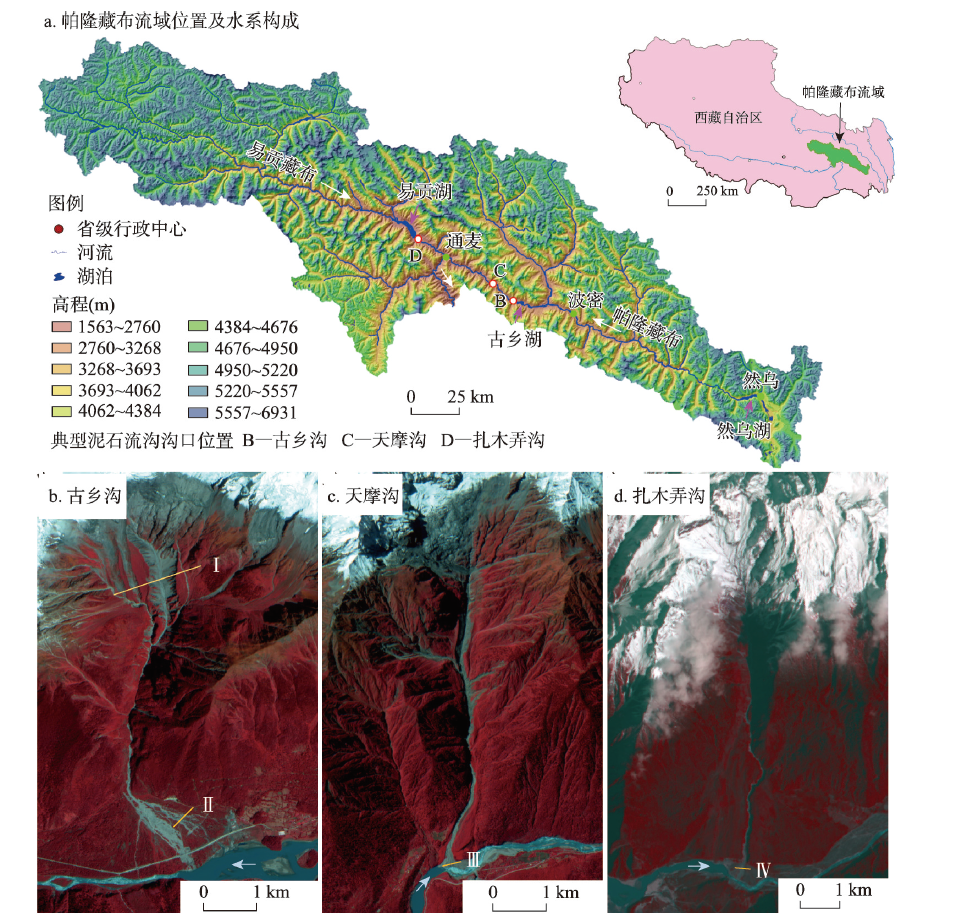
High altitude or high latitude mountain areas, especially alpine glaciers and rapidly shrinking permafrost regions, provide suitable topography and material source for the development of debris flow. Under the influence of climate change, such as rising temperature and increasing heavy rainfall events, the potential hazard inducing environment of alpine regions is more likely to trigger hazards. As an important natural hazard and mass flow type, debris flow has become an important driving force of geomorphologic evolution in alpine regions. However, few research reported debris flow processes and its geomorphologic effects in alpine regions due to the difficulty of field monitoring and lack of data. We first analyzed the morphologic effects of alpine debris flow based on a case study on the Parlung Zangbo basin (with three typical debris flow prone gullies, i.e., Zhamunong, Guxiang and Tianmo), located in southeast Tibet, where debris flow occurs frequently. Combined with remote sensing image, DEM data, UAV aerial photography, high-accuracy survey of RTK and field recording, the geomorphic development characteristics of debris flow gully (such as erosion-deposition variation and wandering) and its influence on river morphology of main channels were analyzed. The long-term evolution of river valley morphology under the influence of large-scale debris flow events was also discussed. The debris flow processes in alpine regions strongly shaped gully morphology. The upstream gully channel is eroded and expanded strongly, and the erosion-deposition variation of debris flow deposited fan is determined by the scale of debris flow events and flow intensity. Debris flows significantly affect the river morphology of a main channel, which lead to lateral scouring/silting and wandering of the main channel, and affect the planform channel pattern development of upstream of the landslide dam. In the long term, the river valley morphology would evolve into a wide and narrow alternating planform and a stair-case like longitudinal profile.
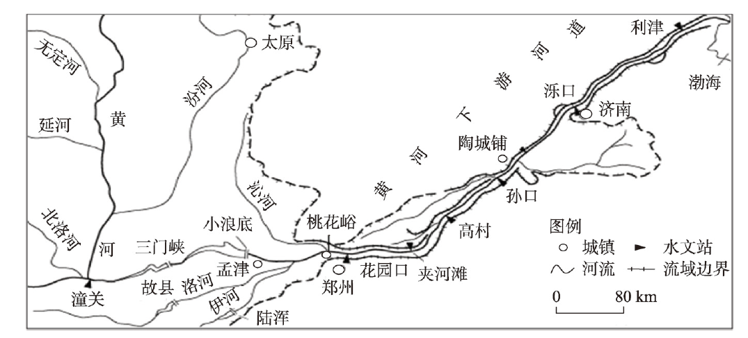
The discharge-sediment relation model is an important research technique in river dynamics. Previous studies established a statistical relationship between the sediment transport rate and the flow discharge that follows a power-law form, shown as Qs=AQ b. Studies have also shown that how to determine the model parameters is an important question. However, for heavy sediment-laden rivers, the discharge-sediment relation model is often expressed by a modified power-law relationship between the sediment transport rate and flow discharge, as well as an upstream sediment supply function: Qs=KSuaQb, where the model parameters become more complex. Essentially, the modified model reflects a non-equilibrium sediment transport law, and model parameters including coefficient K and exponents a and b are mainly influenced by river boundary geomorphologic conditions. As an important index reflecting the spatial scale along the river, distance has an important impact on the modified model parameters, namely, coefficient K and exponents a and b. Taking the Lower Yellow River as the research object, we studied the variation laws of the model coefficient K and indexes a and b with distance. The results showed that the exponent a decreases exponentially with the increase of downstream distance; the coefficient K decreases with the increase of downstream distance and has a positive exponential correlation with the exponent a; the exponent b increases with the increase of downstream distance and has a negative linear correlation with the exponent a; and the sum of exponents a and b is about 2.0. From that, the calculation expressions of model coefficient K and exponents a and b varying with the distance were established. As such, it can be regarded as the parameter supplementary equations for the discharge-sediment relation model. Simulation results of sediment transport along the Lower Yellow River showed that the trend of calculated sediment concentrations are consistent with that of measured sediment concentrations. The values of the determination coefficient and Nash-Sutcliffe efficiency are 0.96 and 0.93, respectively. This study helps us to have a better understanding of the physical meaning and exploration of calculation methods for the discharge-sediment relation model parameters in heavy sediment-laden rivers.
According to the statistics of the United Nations Environment Program (UNEP), fossil fuel (FF) CO2 emission comprises a major proportion of global anthropogenic greenhouse gas emissions. The inverse modeling approach was proposed to verify the results of the traditional bottom-up inventory based on atmospheric concentration (remote sensing and ground-based measurement) in the refinement to the 2006 IPCC Guidelines for National Greenhouse Gas Inventories on the 49th IPCC Plenary Session in 2019. This approach would further promote the development of high-resolution FFCO2 emission inventory which serves as the spatially and temporally distributed form of emission inventory and the prior input data for the inverse model. This paper hereby summarized the spatial distribution and temporal disaggregation approaches of high-resolution FFCO2 emission inventory from global and national scales to a city-wide scale, and put forward the future research prospects based on the specific requirements for high-resolution emission inventories in this 2019 refinement to the IPCC Guidelines: (1) the refined IPCC methodology will help to further improve the spatial and temporal resolution and the accuracy of FFCO2 emission inventories; and the high-resolution FFCO2 emission inventory concerning indirect emissions is emerging. (2) It is a good practice to compile a high-resolution FFCO2 emission inventory with the detailed spatial and temporal information from facility-level emission data, the remote sensing images and the intelligent transportation big data, while the use of geospatial surrogate data or proxy variables, and modeling such as regression, assimilation and artificial neural network, is also necessary to improve the accuracy of the estimates both spatially and temporally when the directly applicable data are unavailable. (3) The uncertainty information of the spatial distribution and temporal disaggregation should be qualitatively or quantitatively analyzed. The atmospheric inversion verification approach, as an independent and objective accounting method, will play an important role in QA/QC and verification of the high-resolution FFCO2 emission inventory.
As a fundamental energy consumption base in China, the Beijing-Tianjin-Hebei (BTH) region has experienced an increasing demand for clean energy in recent years. Photovoltaic power generation is a key for accelerating the transformation of energy infrastructure in China and achieving the goal of carbon neutrality during the 14th Five-Year Plan period (2021-2025). Taking the BTH region as a study area, we construct a comprehensive evaluation index system of "terrain-weather-cost" to calculate a photovoltaic development suitability index. We subsequently analyze the spatial pattern characteristics of photovoltaic development suitability in the study area in 2018 and quantitatively examine power generation potential and emission reduction effect under different scenarios of photovoltaic development suitability. Results indicate that: (1) The suitable areas for photovoltaic development account for 22% of the total area of this region, and the largest portion of this area is moderately suitable for photovoltaic development. The "Yanshan-Taihang mountains" line geographically divides the areas that are suitable and unsuitable for photovoltaic development, and a range of potential areas are distributed in prefecture-level cities of Chengde, Zhangjiakou and Baoding. (2) Photovoltaic power generation in the BTH region has great potential. Specifically, the annual power generation potential of the extremely and highly suitable areas is about three times more than the total power consumption in the same year of 2018. (3) The energy-saving and emission reduction effects of photovoltaic power generation are remarkable. If the extremely and highly suitable areas are used for photovoltaic development, there will be an approximate 47% reduction in carbon emissions across the whole region, according to the data of 2018. (4) Despite being restricted by limited land resources and the absence of an advanced transmission network or energy storage system, large-scale photovoltaic development is still a viable solution to energy supply issues. It still improves energy infrastructure, achieves the goal of carbon neutrality, and enhances the well-being of citizens in the context of global climate change and the new low-carbon economy.

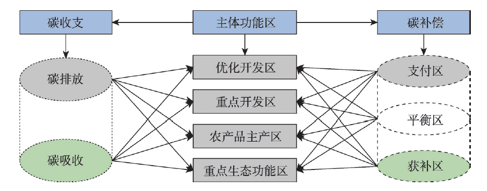
The study of carbon budget and carbon compensation zoning from the perspective of major function-oriented zoning is of great significance for formulating low-carbon development strategies for each functional area, promoting the collaborative governance of regional ecological environment and achieving high-quality development, as well as an important contribution of geographical thinking to the realization of emission peak and carbon neutrality. This paper first constructs the theoretical framework of carbon budget and carbon compensation from the perspective of major function-oriented zoning, and then takes 157 county-level units of Beijing-Tianjin-Hebei Urban Agglomeration as the study area, and introduces the Concentration Index, Normalized Revealed Comparative Advantage Index and the SOM- K- means model to study the spatio-temporal differentiation of carbon budget and carbon compensation zoning of Beijing-Tianjin-Hebei urban agglomeration from the perspective of major function-oriented zoning. The study puts forward a spatial optimization scheme of carbon emission reduction oriented by low- carbon development. The results show that: (1) From 2000 to 2017, the carbon budget of the study area shows an upward trend of volatility, and its centralization index is higher than the "warning line" of 0.4, and overall, there are large regional differences. (2) There are significant regional differences in carbon budget, and carbon emissions show a core-periphery spatial pattern with Beijing-Tianjin-Tangshan as the main high-value center with a gradually decreasing outward; however, the spatial pattern of carbon absorption tends to be stable, showing an inverted "U-shaped" pattern, which is high in the east, north and west, and low in the middle and south. (3) The carbon budget of the study area is consistent with the strategic positioning of the major function-oriented zoning. Optimized development zone and key development zone are the main pressure-bearing areas of carbon emissions, while key ecological functional zone is the dominant area of carbon absorption. The difference of carbon absorption centralization index among functional zones is smaller than that of carbon emission centralization index. (4) There are 53 payment areas, 64 balance areas and 40 obtaining areas in the study area. Combined with the strategic objectives of the major function-oriented zoning, 9 types of carbon compensation space optimization areas are finally formed, and the low-carbon development directions and strategies are proposed for each type of area. (5) In the future, it is urgent to strengthen the research on carbon balance and horizontal carbon compensation in a more micro scale, enrich the theoretical framework of regional carbon compensation, integrate regional horizontal carbon compensation into the carbon trading market, and explore the diversified paths so as to achieve the goal of emission peak and carbon neutrality.
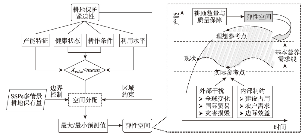
Under new international and domestic situations, scientific analysis of China's cultivated land quantity and its protection ways is of great significance for ensuring national food security and sustainable resources and environment development. This paper analyzes the amount of cultivated land under the constraints of multi-scenario food security within shared social-economic paths (SSPs), using model methods such as cultivated land retention, population forecast, food demand estimation, and yield potential decay. According to the multi-dimensional urgency assessment framework based on productivity characteristics-health status-farming, China's resilience-space for cultivated land protection is delineated by coupling the quantitative boundary control of time series and the regional rules of spatial scale. On the premise of satisfying the assumption of individual basic nutrition security and the constant variables of crop yield conditions, we obtain the following findings. (1) China's multi-scenario cultivated land retention will decline from 2020 to 2100. Existing cultivated land is sufficient to maintain long-term food security, but it barely reaches the critical range of theoretical food security (140 million-159 million hm2) in the short term. (2) The urgency of cultivated land protection in different dimensions presents different distribution characteristics within the nine agricultural zones. The North China Plain and the Middle-lower Yangtze River, which have superior natural conditions suitable for farming, are clusters of high-value plots of comprehensive urgency. (3) The sustainable scenario (SSP1) and the regional conflict scenario (SSP3) represent the minimum and maximum cultivated land retention scenarios under the constraints of food security bottom line. Given the current international situation, China should ensure that the short-term (before 2035) fallow land is not higher than 9.29%. (4) The resilience-space of cultivated land protection delineated based on time and space coupling can be divided into priority protection area, strict control area, rest area, strategic reserve area, comprehensive consolidation area, and special protection area. The flexibility, objectives and tasks of cultivated land protection in different divisions have their priorities. Overall, delineating resilience-space for cultivated land protection facilitates the establishment of spatial planning systems for cultivated land, such as agricultural structure adjustment and fallow policy improvement. This study provide a reference for research on the transformation of China's cultivated land protection system.
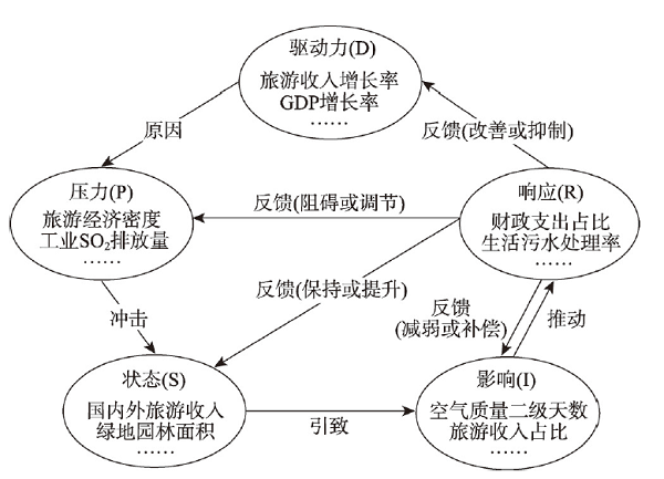
It is of great theoretical and practical importance to measure and examine tourism ecological security in the Yellow River Basin (YRB). The purpose of this study is to promote coordinated and sustainable development of the tourism economy and ecological environment. From the perspective of watershed sustainable development, this paper constructs the theoretical framework and index system of tourism ecological security in the YRB based on DPSIR system model, and analyzes its dynamic evolution characteristics and driving factors by using improved TOPSIS method, kernel density estimation, spatial autocorrelation, traditional and spatial Markov chains and quantile regression panel method. The results showed that: (1) There has been an evolutionary trend toward a dual-core form of tourism ecological security over time, as its average value fluctuates and then rises. The overall tourism ecological security level was relatively low (0-0.55), shifting from the predominant risk level in 2008 (accounting for 89.04%) to the levels of predominant risk and deterioration in 2017 (60.27% and 31.51%, respectively). A large downward risk remains. (2) In terms of dynamic evolution characteristics, the transfer of tourism ecological security risks and sensitive levels had "path dependence" and "self-locking" effects. In practice, however, the probability of maintaining the initial state of the deterioration level and the critical safety level was relatively small. And the type of transfer was usually accomplished during a subsequent level transfer. Its dynamic change process was strongly influenced by regional factors. Its characteristics of dynamic evolution were characterized by significant spatial and temporal heterogeneity. (3) Tourism ecological safety was most significantly influenced by environmental pollution in lower-level units. The tourism load level had a greater positive marginal effect on higher-level areas; however, economic development and level of tourism development have a greater positive marginal effect on areas with lower ecological tourism security levels.
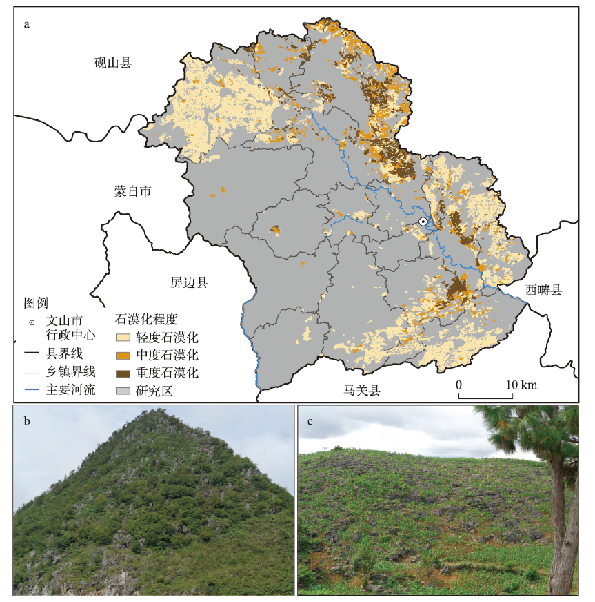
Clarifying the changes of spatio-temporal pattern of ecosystem services and dividing the ecosystem service function zoning will help to achieve the fine management of land resources. The study took Wenshan city, a typical area in the karst mountainous southeastern Yunnan, as an example. We identified six types of ecosystem services in Wenshan from 2000 to 2017, namely, the food supply, water production, net primary productivity of vegetation, soil conservation, habitat quality and tourism culture. Then we examined their spatio-temporal patterns and differentiation characteristics. In addition, we used K-means clustering method to identify ecosystem service bundles and ecosystem service functional zones, and proposed differentiated ecological management measures. The results show that: (1) From 2000 to 2017, all the ecosystem services in Wenshan showed an upward trend, with the exception of the habitat quality service. (2) In terms of spatial distribution, the high-value areas of the six types are concentrated in the west and south, while the low-value areas are concentrated in the north and central parts. There are differences in the spatial distribution of hot and cold spots of the six types of ecosystem services, but they overlap on the whole except for the hot and cold spots of tourism culture service, which account for 2.56% and 0%, respectively, the areas of cold and hot spots account for 21% to 32% for the other five types. Only a small number of regions can provide three or more high-value areas of ecosystem services at the same time, and 85.50% of the regions can only provide two or less high-value areas. (3) According to the cluster results of ecosystem service bundles, Wenshan city could be divided into four types of ecosystem service function zones: ecological protection area, ecological transition area, main agricultural production area, and human production and living area. Differentiated ecological management and control suggestions are proposed for each functional area. The research results can provide references for resource utilization and space management in other Karst mountainous cities.