Sustainable rural development is critical to the achievement of global sustainable development goals. Globalization and urbanization, as the key processes, continuously drive the human-earth system to make adaptive responses, promoting the transformation of urban-rural relations. The rural-urban relationship is essentially a mother-child relationship, which is a comprehensive characterization of the transfer of rural humanistic factors, the transformation of man-land relationship and the transformation of urban-rural development in the process of urbanization. However, the traditional cognition of urban-rural relationship ignores the multi-dimensional connections between the rural and the urban as well as the existence of the rural-urban integration system, resulting in prominent drawbacks of rural regions, negatively affecting the urban-rural development rights, and resulting in urban and rural territorial dysfunction and other problems. The key to solve the problems of socio-economic development in China is to reform the urban-biased development strategy, and to innovate the new cognition of rural-urban relationship based on the thinking of "rural maternal effect", which highlights that rural areas nourish the city. Based on the remote coupling and systematic synthesis of the rural human-earth system, modern human geography urgently needs to strengthen the cross-research with physical geography and information geography, create a coordinated observation system of human-earth system supported by the sky-space-ground integration, reshape the global rural development perspective, rural-urban system perspective, and reorganize the global rural human-earth relationship, the rural-urban integration relationship, and the living and employment relationship. Rural human-earth relationship territorial system is the core of rural geography research. The rural human-earth system research should focus on the coupling of rural natural ecosystem and the socio-economic system and their complex interactive processes and effects. Supported by the intersection of multiple disciplines, the expansion of new fields and the cultivation of new disciplines, it should create the collaborative observation technology of human-earth system and methodology of multi-source data fusion computing, the research idea based on process-mechanism-pattern and the technical path of monitoring-simulation-decision support, and explore the organic connection path between rural human-earth system coupling and rural-urban integrated development, regional sustainable development and global common governance.
"Hu Huanyong Line", T-shaped development model, and dual-nuclei structure model can be roughly summarized as a "one-line, two-axis, and dual-nuclei" structure. They are all rule cognition and theoretical refinements on spatial pattern in China which were proposed by Chinese human geographers in different periods. "Hu Huanyong Line" is proposed based on the regular recognition of regional differences. This is the extension and expansion of geographical differentiation laws of physical geography in human geography, following the basic assumption of homogeneous regions. The discovery of the T-shaped model of Lu Dadao and the dual-nuclei structure of Lu Yuqi transcended the analytical thought of regional differentiation laws. They follow the basic assumptions of functional areas. Among them, the T-shaped model is the practical application of the point-axis system theory proposed by Lu Dadao in China. From the phenomenon perspective, the dual-nuclei structure is attached to the T-shaped development model, but subsequent research has completed the transformation from special to general. It has accomplished the whole process of scientific research in scientific discovery, mechanism analysis, mathematical derivation and practical application. Eventually, it becomes a regional spatial structure theory with strong broad applicability. From the theoretical level, "Hu Huanyong Line" based on the assumption of homogeneous region and T-shaped model based on the assumption of functional region belong to the analysis results of spatial differentiation law, but they can also be called theories. They are individual theories in geography, while the dual-nuclei structure theory belongs to a more general and applicable theory in the general scientific sense. Obviously, the trinity analysis of the "Hu Huanyong Line", the T-shaped model, and the dual-nuclei structure theory shows that, China is a country that is very suitable for regional analysis and geographical laws and theories refinement based on this. The research in this paper can provide research ideas and method references for the summary of regional spatial structure laws and theory refinement of human geography.

China's urban agglomerations are the main area of national new urbanization, the strategic core area of national high-quality development and the responsibility area of carbon neutrality. The science and technology innovation plays an irreplaceable role in realizing the above main goals of urban agglomerations. How to promote China's urban agglomeration to achieve high-quality development and high-level protection of the ecological environment under the new development pattern, and gradually build a world-class urban agglomeration is a realistic problem to be solved. Based on this issue, during the 23rd Annual Conference of the Chinese Association of Science and Technology, with the theme of "Science and technology innovation driving the development of world-class urban agglomerations and the high-quality rise of China's urban agglomerations", the "Regional Collaborative Development Forum and the Second China Urban Agglomeration Development Forum" was specially set up, through systematic discussions of more than 50 well-known experts at home and abroad on urban agglomerations and science and technology collaborative innovation, it is generally believed that the development of global urban agglomerations of China has entered a new era in the 21st century, and the high-quality development of China's urban agglomerations has been promoted to an unprecedented strategic level. However, there are a series of practical problems in the development and planning implementation of urban agglomerations. In the future, the high-quality development of China's urban agglomerations must rely on scientific and technological innovation, and the construction of innovation-driven intelligence, carbon-neutrality, dual circulation and urban-rural integrated urban agglomerations should be the basic direction of high-quality development of China's urban agglomerations. We should further innovate the research work mechanism, establish a collaborative innovation community, and gradually build China's urban agglomerations into world-class urban agglomerations with high-quality development, high-level openness, high-quality life and efficient governance.
Urban space is characterized by both marketing and planning driven attributes, but very few studies were carried out on the scale of their spatial influence in Chinese academia. This paper takes the rural-urban transition zones of 10 cities in Zhejiang from 1980 to 2010 as the case, aiming to conduct multi-level research which was formed between 60 m to 800 m, including courtyard group level, block level, community level, and residential area level, spatial analysis with the market and planning driving forces. It also analyzes the micro-meso space with the generalized spatial multifractal analysis based on five-year data. Through composition of the spatial regularized, trended and disordered land patches, the analysis shows that there were three basic spatial scales (including market-driven courtyard group level space, plan-driven residential area level space, and the transitional interval of the two-block level space and community level space) in the rural-urban transition zones. The results of spatial expansion analysis show that, due to the different leading roles of market and planning at different scales, the spatial evolution at the courtyard group level, community level, and residential area level was dominated by the combination of trend and regularization, while the spatial evolution at the block level was dominated by the combination of trend and disorder. The results of subjectivity analysis further indicate that under the action of the corresponding driving forces, the courtyard group level space was displayed as agglomeration, while the community level space and the residential area level space were shown as diffusion, and the three have obvious trended characteristics. Furthermore, the development of block level space followed a disordered evolution. The contribution of the paper includes the finding of an objective phenomenon that the spatial pattern of the rural-urban transition zones has often been dominated by tendency and regularity, but the evolution subjectivity is dominated by tendency, due to the combination and its sequence changes of the regularity, trend and disordered on the f(a)-a(q) curve. It will provide a specific scientific basis for the spatial scale division and "the system identification of multi-level features" in territorial spatial planning driving forces.
Many scholars have explored the relationship between cultural studies and economics or economic geography, but there is still a lack of in-depth discussion on how regional culture affects spatial agglomeration. To further explain the process of economic agglomeration, this article chooses Krugman's core-periphery model, uses model logic deduction, assists in documentary evidence, to discuss how regional culture can be combined with this model's parameters. This article obtains two conclusions: First, regional culture can affect not only τ in the CP model, but also ρ and μ. Only when cultural geographers carry out comparative research on regional culture, can they transform regional culture into parameters in the CP model for a better understanding of the impact of regional culture on regional economy. Second, according to the definition of place i and j in the CP model, we define the unit of regional culture which will be suitable for the analysis by CP model. In the case that the regional culture cannot be quantified as an absolute value, relative values can be considered to quantify, so as to support the analysis of agglomeration trend, but cannot support to tell an accurate strength of agglomeration. Third, the relationship between regional cultural research and the CP model cannot reveal the nature of uneven development. This combination cannot arouse people's vigilance against cultural hegemony, fetishism, and alienation. Therefore, cultural geography has its own independent academic goals while it is integrating with economic geography.

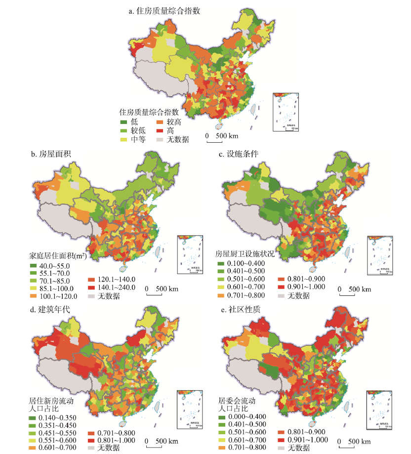
Based on data from the 1% National Population Sample Survey 2015 and the 2014 China Migrant Population Dynamic Survey (CMDS), the paper selects four indicators to measure housing quality of the migrant population including floor area, housing facilities, construction period and living communities (urban or rural) and discusses the phenomenon about spatial differentiation of migrant populations' housing quality in 310 prefecture- and provincial-level cities in China, using GIS spatial analysis methods such as Moran's I coefficient and Getis-Ord Gi*. Besides, we investigate the influencing factors of migrant populations' housing quality. Some conclusions can be drawn as follows: (1) Compared with the local residents, the housing quality of the migrants is not that worse. (2) The spatial distribution of housing quality of migrant population presents marked spatial differentiation on cities of different levels and scales, population sizes and geographical divisions. (3) The results of spatial autocorrelation analysis demonstrate that there is a significant positive spatial correlation in the indicators of the migrant population's housing quality on a national scale, and identify the phenomenon of their spatial clustering and the centers of such spatial clustering. (4) The housing quality is influenced by both internal factors of migrant population and external factors of in-flow cities. (5) Population, economic development and the housing market play different roles in the housing quality of migrant population.
Population migration process has an innate uncertainty with the increasing complexity of regional socioeconomic development. Bayesian model averaging (BMA) provides a feasible solution to the uncertainty of linear regression models. However, model uncertainties are seldom considered in spatial modeling. To reduce the uncertainties in migration modeling, this paper incorporates BMA approaches with spatial origin-destination (OD) models to quantify the spillover mechanism of interprovincial migration in China, 2010-2015. Specifically, we specified network dependence for migration flows and selected origin/destination's population size, gross domestic product (GDP), real wage, urbanization rate, the number of beds in health facilities per 1000 persons, the number of people over college level per 100000 persons in 2010 and migration stocks between 2005 and 2010 as well as railway travel time between provincial capitals in 2010 as explanatory variables. Among 2615 unique models based on 300000 samples using Markov chain Monte Carlo model combination (MC3), 58 models with posterior probability greater than 0.1% were chosen to estimate explanatory variables' origin effects, destination effects, and network effects. Some findings are as follows: (1) BMA model estimates are more robust and reliable. Compared with results from the single spatial origin-destination (OD) model, the widths of 90% credible interval of different explanatory variables are markedly reduced, indicating the degree of model uncertainty has been greatly decreased. (2) Regional population size, quality, and migration stocks have a significant influence on interprovincial migration processes. After model sampling, the inclusion probabilities of population size and GDP at origins, education level and migration stocks at destinations as well as distance variable are beyond 90%. (3) Network effects of most variables are statistically significant, accounting for more than 40% of their corresponding total effects. Moreover, the spillover effects of real wage, education level, and migration stocks are even greater than their corresponding origin and destination effects. (4) The impacts of most explanatory variables on interprovincial migration would be overestimated without considering uncertainties in modeling migration processes.

Using data from the national migration survey of 2018, the intentions of migrants with respect to duration of residence have been categorized into three types, namely, short-term residence, long-term residence, and permanent residence. On this basis, GIS spatial analysis and hierarchical linear modelling (HLM) have been used to examine the determinants and the spatial variation of various categories of residence intentions in 290 prefecture- and provincial-level cities of China. The results show that those with short-term and long-term residence intentions account for 60% of the total number of migrants, suggesting that bi- and multi-locational livelihood strategies are still dominant among migrants in China. It was found that there is a strong contrast between the spatial patterns for short-term residence intentions and that of permanent residence intentions. Furthermore, the short-term residence intentions are relatively high in the eastern region of the country and relatively low in the northeastern region; in contrast, the permanent residence intentions exhibit a spatial pattern completely different from that of the short-term residence intentions, and the long-term residence intentions are the highest in the central and western regions. The HLM results show that the characteristics of both the destination and the migrants at the individual level affect different categories of residence intentions. It is found that the short-term and long-term residence intentions are relatively high, and the permanent residence intentions are relatively low in the eastern and central regions, and in areas with more developed economies and high average wage levels. Moreover, for male, inter-provincial migrating, agricultural hukou status, lower educational attainments, shorter migration duration, and lower average monthly household income, are the factors conducive to short-term and long-term residence intentions; for female, intra-provincial migrating, non-agricultural hukou status, higher educational attainments, longer migration duration, and higher average monthly household income, tend to promote permanent residence intentions.

Considering the new-type urbanization background, the nearby urbanization model provides a practical approach toward eliminating the disadvantage of trans-regional urbanization and promoting urbanization. This study establishes the indexes of the nearby urbanization rate (NU), contribution to nearby urbanization (CNU) and trend of contribution to nearby urbanization (TNU), to analyze the spatial differentiation features of nearby urbanization in central and western China from 2000 to 2015. Moreover, this study explores the determinant factors and influencing mechanism of the spatial differentiation of nearby urbanization in the study region. Results show that: (1) From 2000 to 2015, the population of nearby urbanization increased from 196 million to 347 million and the NU increased from 28.16% to 46.89%. (2) Based on the analysis of the CNU, we found that the main source of nearby urbanization was the population registered in the local town, but the contribution of local town to nearby urbanization (CNUt) gradually declined over the study period. The areas with high CNUt were widely distributed in central and western China in 2000, but by 2015, they were restricted to Sichuan province. Meanwhile, the contribution of local county to nearby urbanization (CNUc) increased and the contribution of local province to nearby urbanization (CNUp) varied slightly. Most areas with high CNUp were provincial capital cities, resource-based cities or pastural cities. (3) Based on the analysis of the TNU, the trend of the contribution of local county to nearby urbanization (TNUc) exceeded the trend of the contribution of local province to nearby urbanization (TNUp), while the trend of the contribution of local town to nearby urbanization (TNUt) exhibited the least influence. Therefore, examining nearby urbanization based on the county-level spatial unit was advantageous in most regions; however, in the northwestern border regions and provincial capital cities, the provincial level was more applicable. (4) The spatial differentiation of nearby urbanization was determined based on the integrated results of various influencing factors, including natural environment, economic development, non-agricultural industries, urban public services, transportation accessibility, and the influence of local administration.
Since the launch of China's reform and opening up policy, the process of urbanization in China has been accelerated. With the development of cities, inter-city interactions have become increasingly close, and urban agglomerations tend to be integrated. Urban agglomerations are regional spaces with network relationships and hierarchies, and have always been the main units for China to promote urbanization and coordinated regional development. In this paper, we comprehensively consider the network and hierarchical characteristics of an urban agglomeration, while using urban flow to describe the interactions of the inter-city networks and the hierarchical generalized linear model (HGLM) to reveal the hierarchical driving mechanism of the urban agglomeration. By coupling the HGLM with a cellular automata (CA) model, we introduce the HGLM-CA model for the simulation of the spatial expansion of an urban agglomeration, and compare the simulation results with those of the logistic-CA model and the biogeography-based optimization CA (BBO-CA) model. According to the results, we further analyze the advantages and disadvantages of the proposed HGLM-CA model. We selected the middle reaches of the Yangtze River in China as the research area to conduct this empirical research, and simulated the spatial expansion of the urban agglomeration in 2017 on the basis of urban land-use data from 2007 and 2012. The results indicate that the spatial expansion of the urban agglomeration can be attributed to various driving factors. As a driving factor at the urban level, urban flow promotes the evolution of land use in the urban agglomeration, and also plays an important role in regulating cell-level factors, therefore, the cell-level factors of different cities show different driving effects. The HGLM-CA model can obtain a higher simulation accuracy than the logistic-CA model, which indicates that the simulation results for urban agglomeration expansion considering urban flow and hierarchical characteristics are more accurate. Compared with the intelligent algorithm model, i.e., BBO-CA, the HGLM-CA model obtains a lower simulation accuracy, but it can analyze the interaction of the various driving factors from a hierarchical perspective. It also has a strong explanatory effect for the spatial expansion mechanism of urban agglomerations.

As a driving force of urban renewal and regional economic development, large-scale events can greatly promote the image and economy of the city. From the perspective of residents' perception, this study used the first China International Import Expo (CIIE) as a case to analyze the social exchange relationship. Based on the Social Exchange Theory, a relational model of "Government Trust", "Consideration of Future Consequences", "Perception of Positive Impacts", "Perception of Negative Impacts", "Quality of Life" and "Attitude towards the first CIIE" is constructed. And the structural equation model analysis was used to explore the rationality of the model construction, and to verify the influencing factors of residents' perceptions of the impacts of the first CIIE and their attitude, as well as the mediating role of quality of life between perception and attitude towards the first CIIE. The results of the study showed that: (1) Residents' trust on the government and consideration of future consequences have an important impact on residents' perception and their attitude. Residents' trust on the government has a significant positive effect on the residents' perception of positive impacts and their attitude, and a significant negative effect on the residents' perception of negative impacts. The relationship among consideration of future consequence, perception and attitude also shows this pattern. (2) Residents' perception of positive impacts has a positive effect on their perception of life quality and attitude; residents' perception of negative impacts has a significant negative effect on their attitude, but has no significant effect on their perception of life quality. (3) Quality of life does not show a significant mediating effect between residents' perception and their attitude. This paper has certain implications and reference values for the sustainable and healthy development of CIIE and the construction of Shanghai as a famous international exhibition city.

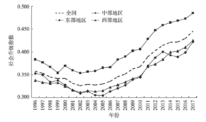
Social upgrading refers to the process of improvement in the quality of employment and securing basic rights of workers as social actors. It is an emerging hot research field of labour geographies in recent years. However, domestic human geography research has been mainly focused on economic upgrading with little attention paid to social upgrading. This paper fills the research gap by establishing a comprehensive index to quantitatively measure social upgrading and revealing the spatiotemporal pattern and driving factors of social upgrading in China since the mid-1990s, using spatial analysis methods and quantitative models. Main findings of the paper include: (1) Social upgrading in China was improved, with its social upgrading index increasing from 0.358 to 0.445 during 1996-2017. (2) The eastern coastal area is the main upgrading area, especially the three urban agglomerations of Beijing-Tianjin-Hebei region, Yangtze River Delta and Peral River Delta. (3) Regional differences of social upgrading among the eastern, central and western regions were narrowed and the differentiation of development rates was alleviated. The central and western regions have been catching up with their eastern partner, despite that the coastal provinces will continue to be the leading areas for social upgrading in China. (4) Factors, including economic development, industrial innovation, economic globalization, labor skill level and state governance, have significant effects in driving regional social upgrading. The effects of these factors are not simply positive or negative in terms of their relationship with social upgrading, suggesting the complexity of social upgrading processes and global-local impacts on it. It is argued that economic growth does not necessarily bring about social upgrading. Rather, promoting social upgrading depends on the improvement in the quality of economic development. The paper contributes to the literature by providing a quantitative framework for analyzing social upgrading at the macro-level and advancing the understanding of geographical differences and driving mechanisms of social upgrading. The paper concludes by proposing some policies for promoting social upgrading and high-quality development in China and discussing its implications for future research.
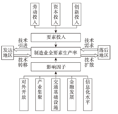
Improving total factor productivity (TFP) in the manufacturing industry is essential to implementing China's manufacturing power strategy. In this study, we employed the super-efficiency SBM model, standard deviational ellipse, spatial autocorrelation, and the geographic weighted regression (GWR) to analyze the spatio-temporal evolution and influencing factors of TFP in China's manufacturing industry from 2002 to 2016. The main conclusions can be drawn as follows: (1) During the study period, the overall trend of TFP in China's manufacturing industry showed an upward tendency of fluctuation, with an increase from 0.58 in 2002 to 0.80 in 2016. (2) The center of the gravity of TFP in China's manufacturing industry showed a "southwest-northeast-northwest" spatial evolution pattern, with its moving distance and speed gradually shrinking. The standard deviation ellipse was mainly located in central and eastern China with its distribution pattern shifting from northeast-southwest to true north-south while tending to scatter in the northeast-southwest direction and polarized in the southeast-northwest direction. The turning angle showed a trend of "shrinking-increasing-shrinking". (3) The positive spatial correlation of TFP in China's manufacturing industry gradually weakened during the study period. High-high agglomeration areas were mainly concentrated in coastal provinces and cities of eastern China such as Jiangsu and Shanghai, while low-low agglomeration areas were mainly in Shaanxi, Gansu, and Sichuan. (4) There are obvious spatial heterogeneities in the factors influencing the TFP of China's manufacturing industry. Financial development is the leading factor in the improvement of manufacturing TFP. Opening-up, industrial agglomeration, and transportation infrastructure have a positive effect on the TFP in the manufacturing industry, while the level of informatization has a restraining influence.
Owing to the multiple influences of globalization, urbanization, industrialization, and informatization, rural regional space has experienced the process of reconstruction. Focusing on the analysis of the internal mechanism of rural reconstruction driven by the internet economy, this study selected Lirendong Village in Panyu District of Guangzhou, the most active Taobao trading village in the Pearl River Delta, as a typical case. We had an in-depth analysis of the process and internal mechanism of the reconstruction of typical Taobao villages in the Pearl River Delta metropolitan area through semi-structured interviews and the actor-network theory analysis framework. The study demonstrated that the key actors, such as local government, clothing workshop, village committee, e-commerce entrepreneurs, and social networks of fellow villagers, participate in the pursuit and realization of land value in the village according to their goal vision and action logic. Furthermore, these actors jointly evolve and construct the actor-network process of periodic industrial succession and spatial value accumulation in Taobao villages. The process has gone through the stage of agricultural decentralization led by the government, the industrialization stage dominated by the market, and the stage of e-commerce dominated by the social network of fellow towns people. Government subject, market subject, and social subject constitute the core driving force. They are linked together by providing benefits, and rural reconstruction practice is carried out according to the political, market, and elite logic. The reconstruction results in the change in spatial-social relations related to the changes in the dynamic mechanism. The reconstruction is realized through the reshaping of space and the change of value, from exogenous driving force leading to endogenous driving force exhibition, thus initiating a new cycle of the space reconstruction process.

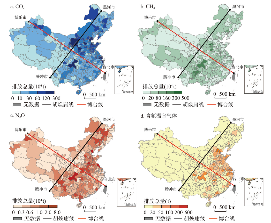
As the international political and economic situation has been undergoing profound changes, achieving regional coordinated development is essential for China to form a new development pattern dominated by the domestic economic cycle. The Bole-Taipei Line, which is perpendicular to the Hu Huanyong Line and is proposed by Professor Fang Chuanglin in February 2020, has the potential to be an appropriate representative of the coordinated and balanced line of China's regional development. By investigating the spatio-temporal distribution of greenhouse gas emissions among 338 Chinese cities from 2005 to 2015, and making use of the Theil index and the Gini coefficient that are appropriate for measuring the spatial equality on both sides of the Bole-Taipei Line and within the southwest and northeast parts, respectively, this paper attempts, for the first time, to underpin the scientific basis of the Bole-Taipei Line as China's regional coordinated development line. We find that: (1) Overall emissions of the carbon dioxide (CO2), methane (CH4), nitrous oxide (N2O) and fluorinated greenhouse gas show a balanced distribution on both sides of the Bole-Taipei Line, and there are small regional differences in sectoral CO2 emission intensity and per capita CO2 emissions. (2) There is a generally balanced distribution of greenhouse gas emission intensity and per capita emissions, as well as the sectoral CO2 emission intensity and per capita emissions within the southwest and northeast parts of the Bole-Taipei Line. The industrial and agricultural sectors serve as the major emitters of greenhouse gases and therefore require a low-carbon transition towards a more balanced distribution of greenhouse gas emissions on both sides of the Bole-Taipei Line. In conclusion, the greenhouse gas emissions as a measure of the magnitude of human activities on both sides of the Bole-Taipei Line are relatively balanced, which has justified the scientific robustness and rationality of the Bole-Taipei Line as a strategic line for socioeconomic development, and provided novel insights into China's regional coordinated development.
County is the pivotal platform and region unit to realize the new-type urbanization. The study of county-level CO2 emissions is of great significance to improve China's urbanization strategy, accelerate the achievement of ecological civilization and low-carbon transformation. Based on the data of China's county-level CO2 emissions from 2000 to 2017, this paper analyzed the overall tendency, regional differences, spatiotemporal pattern and agglomeration characteristics of per capita CO2 emissions. Meanwhile, under the STIRPAT model and EKC hypothesis, this study employed the panel quantile regressions to explain the dynamic impact of socio-economic development on per capita CO2 emissions. The main conclusions show that: (1) China's county-level CO2 emissions show an increasing trend of rapid growth followed by slow growth. The regional disparity of per capita CO2 emissions is distinct and shows a more uneven trend. (2) On the whole, China's county-level CO2 emissions present a spatial pattern of "high in the north and low in the south". The per capita CO2 emissions level in economically developed areas is much higher than that in other areas, thus brings about an obvious spatial polarization effect. (3) There is a significant positive spatial correlation of per capita CO2 emissions within counties. The number of counties with High-High concentration gradually increases and the distribution center gradually moves to Northwest China, while the number of Low-Low concentration counties decreases continuously and they were mainly distributed in the central and southern regions. The agglomeration type of county-level per capita CO2 emissions presents a spatial locking effect. (4) Population density and government expenditure have an inhibitory effect on county-level per capita CO2 emissions, while the scale of secondary industry output value and carbon emission intensity have significant promotive influence. And there is an inverted "N-shaped" relationship between economic development and per capita CO2 emissions in the counties with low- and middle-level emissions. The adjustment of socio-economic development structure plays a critical role in achieving China's total CO2 emission reduction target. Therefore, the policy makers of emission reduction strategy should consider the regional disparity to realize the development and transformation of backward counties. And the key urban agglomerations should play a leading role in carbon emission reduction simultaneously. In addition, improving energy use efficiency through technological innovation should be the key way to the reduction of carbon emissions in China's counties at the present stage.
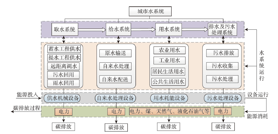
Discovering the inherent mechanisms between water cycle process and carbon emissions in urban water system is of important theoretical and practical significance for promoting water-energy conservation and low-carbon optimization. From the perspective of "water-energy-carbon" nexus, a theoretical framework and a series of calculation methods of carbon emissions within urban water system were established in this study. Based on statistical data from 2008 to 2017 and data obtained through questionnaires, the carbon emissions of water system in Zhengzhou city were calculated according to the energy consumptions of each subsystem. The characteristics of water-energy-carbon nexus in water system were demonstrated, based on which further analysis was made under different scenarios of carbon emission reduction potential. The main conclusions are as follows: (1) Water system of Zhengzhou city involves various subsystems, including water intake, water supply, water use, and wastewater treatment. The carbon emissions of urban water system were not only influenced by the amount of water supply and use, but also affected by the mode and distance of water delivery, energy type, structure and efficiency of operation facilities, and terminal use in each subsystem. Water use subsystem was the main source of carbon emissions, indicating that the main reason for the growth of carbon emissions was the increasing water demands driven by urban expansion and population growth. (2) There exist huge differences in carbon emission composition and intensity, as well as the temporal changing trends of carbon emissions among different water subsystems in Zhengzhou. Specifically, the intensity of energy consumption and carbon emissions of water intake and water use increased obviously, while it was relatively stable in water supply and wastewater treatment. Attentions should be paid to the increase of energy consumption of water intake and water use system, especially the increase of carbon emissions caused by long distance water supply and the reuse of raw sewage. (3) The different characteristics of "water-energy-carbon" nexus of different subsystems of water system in Zhengzhou were mainly affected by changes of water use, water treatment methods and processes, residential water use habits, water conservation awareness, natural conditions, and climate change. (4) In the future, water system efficiency should be improved to reduce energy consumption and carbon emissions. Effective measures include urban industrial and domestic water saving, water treatment process improvement, water saving promotion, water system optimization, low-carbon management, and energy efficiency improvement.