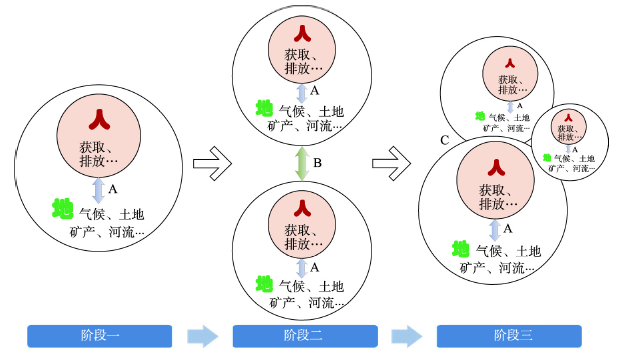
The early studies on the relationships between man and land in geography mostly focused on local regions and held the idea that "the land and water resources in a region feed the person in the region". In the traditional agricultural society, which relies heavily on natural resources, the idea, and regional geographic research and management practice under its guidance play a positive role in promoting the development between man and nature, and sustainable resource use. With the continuous increase in openness of man and land system resulted from development of science and technology and transport improvement, regional systems on different scales and at different economic development levels have formed an interdependent and coupled geographic network. Every region becomes a node in this network, and the formation and solution of regional problems are closely related to other nodes in the network, and are related to internal and external factors of the regional system. In some cases, external factors even play a more important role. The introduction of some concepts and methods marks the paradigm transformation of man-land relationship research from local thinking paradigm to global networked thinking paradigm, such as virtual water, ecological footprint, carbon emissions due to goods trade, resource link and tele-coupling of man-land relationship. This study discusses the paradigm transformation from three aspects: the evolution characteristics of man-land system, the changes of thinking paradigm and study methods in man-land relationships, and the realization paths and practical significances of the transformation of thinking paradigm in man-land relationship research. According to new ideas and thinking paradigms, traditional local thinking modes and related research themes such as regional carrying capacity can not fully express the new characteristics of man-land relationships. At present, studies related to regional carrying capacity have become an important issue in land use planning and urban planning in China. In the development of land use planning at different levels, "evaluation of resource and environmental carrying capacity" has become the premise and basis of planning. In the implementation of this concept, we usually simply uses population size as the control index. In the context of an increasingly open system, studies in the carrying capacity of resources and environment may be re-examined. This is especially necessary in smaller scale regional systems (e.g., at a county level).
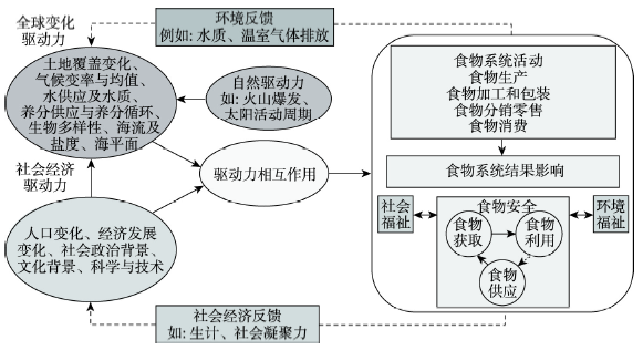
Driven by urbanization, regional functional differentiation, optimal allocation of production factors, and rapid expansion of transportation networks, the flow of resources between regions has become a key impetus for regional sustainable development. Hence, the interaction networking between human beings and their natural environment requires a meta-coupling paradigm research from a geographic perspective, that is, to consider the human-nature interactions within the region, between the region and surrounding regions, and between non-adjacent regions simultaneously. As an industrial chain and value chain that connects rural areas and cities, as well as production areas and global consumer markets, the research on food system couplings is a good and important entry point for a better understanding the interactions and networking in the human-earth system. With this perspective in mind and aiming at demonstrating the theoretical study based on internal basis and external conditions, this paper combines the food system components with the tele-coupling framework to establish a "theoretical framework of local and tele-coupling of food systems driven by urbanization", and discusses the specific connotation of the theoretical framework. Taking the extension of the frontier fields in the theoretical framework as the basic guide and combining China's major strategic needs, the paper further identifies the basic issues for food system coupling research and four priority research directions that need to be breakthrough. Among them, the pattern characteristics, the spatio-temporal evolution and its driving mechanism of foodshed are the basic issues, while the four research priorities include: human-nature interaction research of the supply chain network coupling socio-economic and cultural changes and biogeochemical cycles; effects of the local and tele-coupling of food system and its regulatory strategies; the mechanism of urban-rural integration and long-term poverty alleviation based on food system; and cross-regional multi-level governance of food systems for public health and food security. A general technical methodology of the food system coupling research is designed at the end of the paper. The conceptual framework and methodology in this paper can provide theoretical guideline and enlightenment for further food system coupling research and other similar studies.
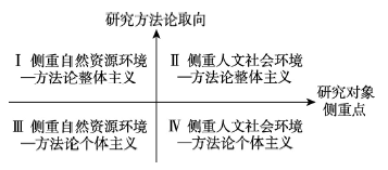
The human-environment relationship in tourism phenomenon and activity is an interdisciplinary subject with theoretical and practical significance. However, human-environment relationship research in tourism context is distinctive due to the particularity and comprehensiveness of tourism phenomenon, with certain psychological and behavioral research gaps on ontological level and from microcosmic perspective. This paper, firstly, investigates the research pluralism as well as the basic situations and typical paradigms of human-environment relationship in tourism context, and probes into the possible empiricalization and ontologization approach to human-environment relationship research in the tourism context from a microcosmic perspective; and then it explores a possible theoretical mechanism of which dualistic human-environment stimulus leads to human-environment relationship and then to behavioral response in case of tourist behavioral intention based on stimulus-organism-response theory, and tests the hypothesized model based on empirical data collected in a typical study site; finally, it analyzes the inspiration for human-environment relationship research in tourism context stemmed from the above theoretical and empirical research. The research indicates the following: (1) There are four basic situations and two typical paradigms in human-environment relationship research in tourism context, which are diverse in research objects, scales, paradigms and methodologies. (2) The psychological-behavioral paradigm is an important direction to expand human-environment relationship research, while proposing concrete questions and focusing on specific variables are the key approach to empiricalization and ontologization of human-environment relationship research in the tourism context from a microcosmic perspective. (3) The empirical model composed of perceived cognitive image and affective image, place attachment as well as behavioral intention reflects the theoretical logic of human-environment duality to human-environment relationship to a certain extent, which provides a possible microcosmic explanation for human-environment relationship in tourist behavior. (4) The formation of tourist behavioral intention from a microcosmic perspective has experienced a transformation from two dimensional stimulus oriented to environmental function and human affection to human-environment organism of place attachment and then to behavioral response. (5) The human-environment relationship research in the tourism context from a microcosmic perspective requires that we grasp the theme of human-environment relationship and characteristics of tourism phenomena, improve diverse perspectives, scales and paradigms, promote the empiricalization of grand theories, and emphasize problem orientation and theoretical significance of certain methods and techniques.
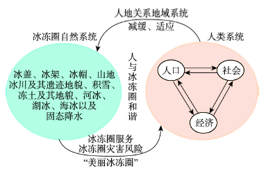
The basic connotation of "Beautiful Cryosphere (BC)" is firstly discussed in the paper. After that, the relationship between BC and regional sustainable development is analyzed from two aspects of natural and social economy attributes of the cryosphere, and from two lines of cryospheric profit and harm. BC, regional social and economic development, and human well-being constitute the cryosphere and huaman social and economic complex destiny community. There are significant regional differences for cryosphere changes and their effects in China. Therefore, the Qilian Mountains-Hexi Corridor region, the Three Rivers Source Region (Yangtze, Yellow and Lancang rivers) over the Tibetan Plateau and the Great Shangri-La region are selected to represent the impact area of cryospheric water resources, the cryospheric disaster affected area, and cryospheric tourism economic zone, respectively. This paper mainly focuses on the core issues of cryospheric water resources services and oasis economy, snow disaster risk and animal husbandry development, ice and snow tourism and regional economy, analyzes in detail the approaches and models of BC integration into regional development from the perspective of cryosphere service and disaster risk. In arid and semi-arid inland areas, the cryosphere resources are integrated into the oasis social and economic development mainly through water conservation, water supply and runoff regulation services, so we built a cryosphric water resource-supported development model. In the alpine region of the Tibetan Plateau, cryospheric ecological environment determines the vulnerability of animal husbandry economy, and cryospheric hazards negatively affects the animal husbandry economy, which is a kind of cryospheric ecology-supported and cryospheric disaster-influenced development model. The cryospheric tourism economic zone that directly depends on ice and snow resources can develop ice and snow tourism, which is a kind of tourism economy-driven development model based on cryosphere resources.
It is significant to analyze the renewal potential of urban land use in China. Enterprise communities (ECs) are a major type of gated and walled-off residential space. They were mostly built and managed by the state or collectively-owned enterprises to meet the housing and livelihood needs of workers during the planned economy period from the 1950s to the 1970s, and many are still occupied in urban China. As a result, ECs exist in most cities need renewal. In this paper, an analysis framework of ECs' renewal potential in the city is constructed to probe into the renewal potential and its spatial distribution characteristics. The framework consists of three dimensions: renewal potential of land area, potential for spatial intensive utilization and their relevance. Point of interest (POI) data, area of interest (AOI) data and data of floor area and methods such as index of landscape pattern, location quotient and importance-performance analysis are adopted. Further, Xi'an is chosen as a case city to verify applicability of the analytical framework. The results are shown as follows: (1) Total renewal potentials of the ECs in Xi'an are 933.56 hm2, with an average area of 1.63 hm2. Small-sized ECs (0.07-1.18 hm2) are the majority (62.87%), mainly concentrated in Taoyuanlu, Tumen and Changlezhonglu sub-districts near the downtown, but the potentials for area renewal are relatively minor (19.42%). ECs with large land area are scattered, distributed in Hongqing, Fangzhicheng, Yuhuazhai and other sub-districts away from the downtown. (2) The vast majority of ECs (93.01%) have the potentials of intensive use in three-dimensional space, showing a pattern of slightly U-shaped spatial differentiation with higher at both ends of the east and west and lower in the middle of the inner city, as well as a near-linear increasing trend from the south to the north-central region. (3) ECs of type B with great potentials for intensive use account for 55.94%, with an average of 5.24 floors and spatial characteristics of small aggregation and large dispersion, mainly distributed in the sub-districts of Changlezhonglu, Fangzhicheng, Dianzicheng and Taoyuanlu. The ECs of type A with the highest potentials cover 20.63%, with an average of 3.31 floors, mostly in Tumen, Taoyuanlu, Fangzhicheng, Hansenzhai and other sub-districts. (4) ECs of high-high type with great potentials for area renewal and intensive use come up to 13.46% (77), primarily distributed in Fangzhicheng, Dianzicheng, Zaoyuan, Hansenzhai and other sub-districts outside the central city. ECs of low-high type with small potentials for area renewal and high potentials for intensive use reach 30.07% (172), principally in Tumen, Fangzhicheng, Taoyuanlu, Dianzicheng and other sub-districts. Renewal and development construction of ECs including the high-high and low-high types need be more focused in the future.

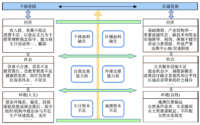
China's poverty alleviation practice has proved that geography has played an extremely important role in supporting anti-poverty targeting and poverty reduction decision-making. However, due to vague basic concepts, lagging basic theories, and an imperfect discipline system, "theoretical poverty" has become the biggest shortcoming restricting the innovation and development of poverty geography. Based on the analysis of the core concept of poverty, this paper systematically analyzed the nature, basic theory, research object, research content, and framework of poverty geography as a branch of the discipline, and put forward the frontier areas of future research on poverty geography. The results show that firstly, poverty refers to the state of inferiority, lack, or insufficiency of various welfares enjoyed by people compared to a certain standard, which has multidimensional, regional, and dynamic characteristics. In terms of measurement standards, absolute poverty emphasizes the minimum value, and relative poverty emphasizes the average value. In terms of target objects, poverty can be divided into individual poverty and regional poverty. The former focuses on the lack and deficiency of individual welfare or capability, while the latter focuses on the regional welfare behind individual welfare from the perspective of space. Secondly, poverty geography is a discipline that studies the formation, distribution, geographic characteristics of poverty-stricken areas, their relationship with the environment, and anti-poverty measures. It takes the impoverished areal system (IAS) as the research object and the poverty-environment nexus as the research core. It has comprehensive, cross-cutting, and regional characteristics, focusing on the study of regional poverty. The basic theories of poverty geography include spatial poverty theory, regional poverty theory, multidimensional poverty theory, and sustainable development theory. Its research content and framework include three dimensions (economic, social, and environmental poverty), two elements (nature and human), two types of objects (regional poverty and individual poverty), and two standards (absolute poverty and relative poverty). Thirdly, there is an urgent need to strengthen the basic research of poverty geography in terms of the evolution of IAS, regional poverty measurement, relative poverty targeting, poverty dynamic monitoring and simulation prediction, urban poverty and rural poverty, poverty alleviation effectiveness evaluation, transformation and development and revitalization path of poor areas. In the situation that we face new challenges of poverty reduction and development at home and abroad, there is an urgent need to constantly innovate and develop the fundamental theory of poverty geography, promote the globalization of China's poverty research, and contribute China's anti-poverty project to the eradication of global extreme poverty.
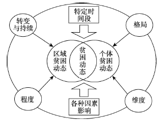
Studying poverty as a dynamic process has gradually become a consensus in the research of poverty. In this paper, we conduct a comprehensive review on the existing poverty dynamics. We first introduce various poverty dynamics, as well as their connotations. Then we review the theory, feature and data collection method of the poverty dynamic measurements, from both uni-dimensional and multi-dimensional perspectives. Third, we provide a thorough categorization for poverty dynamics in four aspects, namely duration, inter-generational transmission, family life cycle, and spatio-temporal evolution. Finally, we interpret the mechanism of poverty dynamics in terms of economy, development and space from an interdisciplinary perspective, which involves economics, sociology and geography. The review helps us identify issues for further exploration of poverty dynamics. Our systematical review would shed light on future research on poverty dynamics and provide theoretical support for poverty alleviation policies.
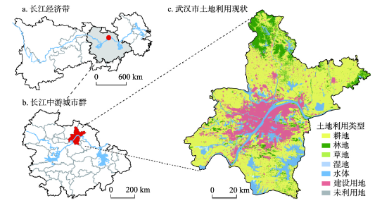
The resources and environment carrying capacity (RECC) is a barometer of the development of urban territory space, so exploring the spatial characteristics of RECC is greatly significant for optimizing the territory spatial pattern. In this context, this paper uses new urban geographic information data, such as night-time lights and atmospheric remote sensing, points of interest, historical traffic situation and social media, on the basis of relevant procedures and guidelines. Furthermore, a theoretical framework based on the covert-resilient-overt analysis of the spatial characteristics of urban RECC is proposed, and a method combining spatial autocorrelation and fractal geometry is developed for spatial characteristics mining of RECC. Taking Wuhan as an example to carry out research, the results show that: (1) The distribution of RECC in Wuhan has significant spatial heterogeneity. Areas with higher covert carrying capacity are concentrated in the Huangpi District and Xinzhou District with superior ecological environment in the northern periphery of the city, areas with high resilient carrying capacity are concentrated in the central urban area with strong comprehensive risk response capabilities, and areas with high overt carrying capacity are located in the sub-center of the city with sound basic functions. (2) The RECC in Wuhan has positive spatial aggregation, and it shows significant radius-centripetal fractal and circle characteristics. The areas of high covert carrying capacity spread radially around, and the areas with high resilient carrying capacity are concentrated in the core of the city in a centripetal shape, the areas with high overt carrying capacity are between the areas with high values of covert and resilient carrying capacity. In conclusion, the spatial characteristics analysis and mining method system of urban RECC constructed in this paper make up for the shortcomings of the low dynamics of traditional data by introducing multi-source spatial temporal data, and improves the theoretical and technical paradigm of urban RECC research. The research provides a new way of thinking for the carrying capacity of urban resources and environment.
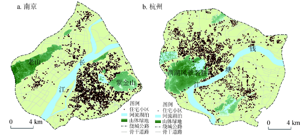
Residential differentiation is a timeless and classic research topic in the field of urban geography and urban sociology. Urban residential differentiation contains dual socio-spatial attributes of social group differentiation and residential differentiation. Existing studies rely largely on population statistics and social survey data, from the perspective of differentiated social groups to effectively reflect, verify and analyze data from a single city. This empirical analysis is unable to effectively reflect the increasing complexity, heterogenous and fragmented situation of residential differentiation in large cities. There have been fewer comparative studies between similar cities. This paper, in the perspective of residential space, uses housing price as an indicator, and adopts methods such as multi-group segregation index, multi-group spatial segregation index and geographic detector. In particular, Nanjing and Hangzhou from 2009-2018 are taken as cases and census track, block and grid as basic units to carry out a quantitative study on residential differentiation and comparison in Nanjing and Hangzhou at multiple spatial and temporal scales. Through analysis of the above data, the following is observed: (1) Urban residential differentiation, characterized by residential difference, is more time-sensitive and accurate, and spatial segregation index is a correction to the traditional non-spatial segregation index. (2) The high and low-priced housing spatial segregation index in Nanjing is significantly higher than that in Hangzhou, of which spatial structure is a significant factor. (3) The influencing factors and combined features of residential differentiation in Nanjing and Hangzhou show certain similarities, of which "central location" and "education package" have the strongest explanatory power. As an innovative exploration, this paper attempts to provide new perspectives, methods and ideas for studies on urban residential differentiation, hoping to enrich the research on Chinese urban social geography in the new era.
In the context of rapid urbanization, shrinking cities cannot be ignored. The classification of shrinking cities according to the patterns of urban population changes is the key to reveal the "hollow" and changing characteristics of the population. Researchers classified the shrinking cities in Western developed countries as "perforated", "doughnut" and "peripheral" types. However, there is a lack of evidence showing the types of shrinking cities in China. This paper takes the redefined physical cities in China (excluding Hong Kong, Macao and Taiwan) as the study area, and employs Baidu Huiyan's 200 m × 200 m grid cell permanent population data from November 2016 to November 2018 to identify different types of shrinking cities in the country. Our results show that 1506 physical cities have experienced a population reduction between 2016 and 2018, accounting for 49.8% of the total number of physical cities (3022). Furthermore, in order to accurately identify the types of shrinking cities, 126 densely populated and severely shrinking cities during the study period were selected as the research samples, mainly located to north of the Qinling Mountains and Huaihe River of China. Our analysis shows that the shrinking types of the sample cities can be classified into five categories: "perforated", "complete", "local", "doughnut", and "peripheral". The number of cities with perforated shrinkage is the largest, which numbered 47 (37.3% of the sample cities), most of which are found in Heilongjiang Province, Inner Mongolia Autonomous Region and Gansu Province. Complete shrinkage ranks the second, including 33 cities, which accounts for 26.2% of the samples, and mainly distributed in Gansu and Shaanxi provinces. The numbers of shrinking cities with local, doughnut and peripheral types are 25, 18 and 3, respectively. These cities are mainly distributed in Heilongjiang and Inner Mongolia. This is because the governments paid more attention to the development speed over quality during the first half of China's urbanization process, and adopted a growth-oriented urban planning strategy. Traditional industries declined due to resource depletion or economic transformation, and the transfer of industries under active government adjustment, all of which contribute to the emergence of perforated shrinkage. This study could provide scientific evidence for micro management of urban development, optimization of land use pattern, improvement of urban livability, and conduct of urban planning and design in the context of urban shrinkage.

Promoting the transformation, upgrading, and high-quality development of resource-based cities is a key point to achieve high-quality development in China. The comprehensive evaluation of the high-quality development of resource-based cities and the analysis of its influence mechanism can not only enrich the relevant theoretical research, but also have important practical significance. Based on Marxist political economy, this paper reviews and analyzes the theoretical framework of high-quality development in the new era, and systematically constructs the index system of high-quality development of resource-based cities. On this basis, the high-quality development level of 117 resource-based cities is comprehensively estimated, and its influence mechanism is analyzed. The results show the following. (1) From 2005 to 2017, the high-quality development level of resource-based cities continued to grow, showing a significant spatial distribution pattern of "relatively high in the east, but relatively low in the west and northeast". (2) The cities with higher and lower high-quality development levels have obvious regional agglomeration characteristics, but the local imbalance of high-quality development level intensifies, and the phenomenon of spatial polarization continues to expand. (3) The high-quality development level of cities in different growth stages is quite different. Among them, the high-quality development level of regenerative cities is the highest, while that of declining cities is the lowest. (4) The distance between resource-based cities and provincial capital cities or municipalities directly under the central government, natural factors (such as location, and altitude of cities), and the open time of cities have an important impact on the high-quality development level of resource-based cities.

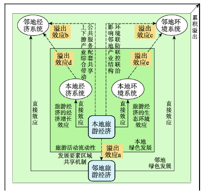
Ecological priority and green development has become one of China's national strategies. Additionally, the scientific understanding of the green externality of tourism economy and its spatial spillover is still insufficient. Therefore, in terms of theoretical and practical significance, it is necessary to demonstrate whether China's tourism economy can promote green development and reveal its spatial spillover characteristics. On the basis of constructing the spatial spillover mechanism of green development effect of tourism economy, this paper selects green total factor productivity (GTFP) as the evaluation index of urban green development level based on bibliometric analysis; integrates multi-source data and uses EBM-GML model to calculate and decompose the GTFP of 284 cities at prefecture level in China from 2005 to 2016; uses the spatial analysis method to describe the spatio-temporal pattern and spatial clustering of GTFP at prefecture level. Based on the spatial Durbin model, this paper reveals the impact of tourism economy on green development and spatial spillover effect. The results show that: (1) the annual average of GTFP in eastern, central, western and northeastern China showed an overall upward trend. Eastern China has the largest improvement in GTFP (accumulated growth of 48.08%), followed by the western region (accumulated growth of 44.18%) and the northeastern region (accumulated growth of 36.05%), while the central region has the lowest improvement (accumulated growth of 26.56%), so that the "Central Collapse" feature is obvious. Moreover, there is a spatial dislocation between China's GTFP pattern and its economic map at the prefecture level. (2) The tourism economy could significantly promote the growth of local GTFP in tourist destinations by simultaneously promoting green efficiency change (GEC) and green technological change (GTC). (3) The spatial spillover mechanism of tourism economy on green development is reflected in the fact that tourism economy can significantly improve the GEC in neighboring cities, but it cannot significantly promote the GTC in neighboring cities. (4) In terms of policy, it is necessary to strengthen the linkage development of tourism economy within the region, and build an innovative spillover mechanism for tourism destinations. In addition, it is feasible to promote the coordinated development of tourism destinations and neighboring industries, and create a regional industrial ecosystem and complex with deep participation in the tourism industry.
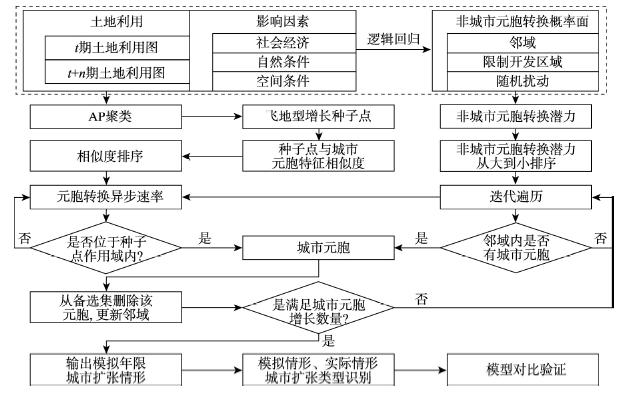
Cellular automata (CA) has been widely recognized as an effective approach in the simulation of spatiotemporal dynamics of metropolitan areas, particularly for infilling and edge urban expansion processes. However, the traditional Logistics-CA has its severe drawbacks in simulating outlying expansion, since it evolves primarily according to the status of a set of neighboring cells, failing to identify other potential seeds that could also stimulate urban expansion in a significant way. This paper develops an advanced CA, called APCA, by using Affinity Propagation (AP) to comprehensively search for urban expansion seed points, as well as by realizing a synchronous simulation of diffusional and aggregational processes of urban cell. This paper uses the data of Wuhan, the largest provincial capital in central China, to validate the effectiveness of APCA. By simulating Wuhan's urban expansion dynamics between 1995 and 2025, the APCA (1) identifies that the total areas of outlying expansion amount to 8.67 km2, accounting for 6.30% of added urban land of the city; and (2) successfully simulates a process of "first diffusion and then aggregation" in Wuhan, which is in harmony with the Phase Theory of urban expansion. Compared with the traditional Logistics-CA, the overall accuracy of APCA remains higher regardless of the number of seed points as long as they are within 1-8, while the accuracy of APCA reaches its highest (0.5217) when the seed point is set as 6. The APCA contributes to the two-dimensional CA framework by expanding surface-dimension simulation to point-dimension simulation, and thereby facilitates effective and accurate simulations of urban expansion patterns.
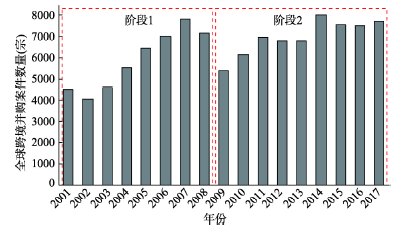
Cross-border M&A (mergers and acquisitions) is an important way for enterprises to carry out overseas strategic layout, which has a significant impact on the pattern evolution of world economic geography. Based on record data of global cross-border M&A transactions from 2001 to 2017, a national-based network for the global scales is established to explore the evolution process and growth mechanism of global cross-border M&A network via the complex network analysis, the GIS method, and the spatial gravity model. Several conclusions can be drawn as follows. (1) The scale, density, and scope of the global cross-border M&A network have increased slightly, while there exists a trend of decentralization. (2) There is a sign that the center of gravity has been shifting from Western Europe and North America to the Asia-Pacific region for global cross-border M&A network, which is mainly driven by China. However, Chinese import and export of cross-border M&A largely rely on Hong Kong, British Virgin Islands, Cayman Islands and so on. (3) There is a process of division and integration for condensing subgroup of global cross-border M&A network. Among them, the scope of condensing subgroup led by the UK and the US has been narrowed, while that led by China has been expanded, and the European condensing subgroup has been further integrated. (4) The evolution of global cross-border M&A network to varying degrees was influenced by the indicator attributes for each country (region), which was in turn related to the science and technology level, offshore financial center, as well as proximity indicators, which were related to geographical conditions, language and history. However, natural resource endowment and economic market size for cross-border M&A linkages only have one-way (receiving or output) effect, and economic proximity index is not significant in 2009 to 2017.
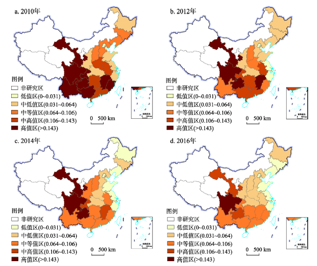
Global multidimensional poverty has arouse great attention from the public. It is of great theoretical and practical significance to explore the spatial and temporal changes of multidimensional children poverty and its influencing factors. Taking 25 provinces (municipalities and autonomous regions) of China as an example, this study uses the A-F method to measure children multidimensional poverty of China during 2010-2016, and examines its spatio-temporal pattern and influencing factors with spatial autocorrelation and the geodetector. The results demonstrated the following: (1) During 2010-2016, the children multidimensional poverty index in eastern, central and western China showed a downward trend, and poverty in the dimensions of living standards, care, education and health were effectively improved. (2) The children multidimensional poverty index and each dimensional poverty index had spatial differences, which was manifested as "high in the east, medium in the central region, and low in the west". (3) Urban and rural children multidimensional poverty in China has been improved, and the index spatial pattern has gradually changed to "east, middle, west; high, middle, and low", however, the multidimensional poverty index of rural children has been far higher than that of urban children. (4) Family environment and urbanization level are important factors affecting children multidimensional poverty. Ability of raising children, economic level and educational environment are secondary factors. The interaction between the factors has a far greater impact on children multidimensional poverty than a single factor. Educational environment and ability of raising children, urbanization level and medical resources, and family environment are the main interactive factors leading to children multidimensional poverty.
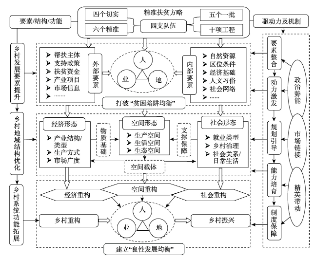
As a "package of projects", the targeted poverty alleviation strategy has accelerated economic, social and spatial reconstruction of rural areas. This paper aims to conduct a theoretical analysis of the connotation, characteristics, process, and mechanism of targeted poverty alleviation that drives poor rural reconstruction and provide empirical evidence of Shibadong Village, which is the first initiative of targeted poverty alleviation. It is found that targeted poverty alleviation is a process of multidimensional, comprehensive, and rapid reconstruction that is led by the government with multi-party participation in combination of "top-down" and "bottom-up" approaches. The process of targeted poverty alleviation changes the poor rural areas from 'low-level poverty equilibrium' to 'healthy development equilibrium' through a combination of administrative power, sending elites to the village level, improving market accessibility, and coordination of factor integration, motivation, planning, training and institutional guarantee mechanisms. Since the implementation of the targeted poverty alleviation, Shibadong Village has transformed from a dualistic economy to a pluralist economy, from a pure acquaintance society to a semi-acquaintance society with a mixture of acquaintance logic and contract spirit, and from a spatial form highly overlapped from the production and living spaces, yet separated from the ecological space to a diverse and orderly cluster of organic integration of production, living and ecological space. The practice of Shibadong Village provides a fresh sample for us to understand the process and mechanism of the restructuring of poverty-stricken villages, and it is also an essential embodiment of its "reproducible and extendable" experience.
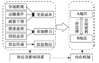
Market spatial correlation is one of the key indicators that reflect the operation efficiency of corn markets. The implementation and reform of corn price support policy in China plays an important role in changing the spatial correlation of corn markets. Employing market price data at province level, this study first analyzed the change of corn market spatial correlations under the price support policy reform. Then, social network analysis was applied to describe the network characteristics of corn market spatial correlations, and quadratic assignment procedure (QAP) analysis was used to investigate key factors that affected the spatial correlation. The results indicated that, (1) overall, the spatial correlation of China's corn markets was relatively high, and there was an upward trend in recent years. The implementation of temporary corn storage policy exerted insignificant effect on this upward trend, but it led to a decrease in the spatial correlation between markets in policy-affected provinces and those in non-policy affected provinces. (2) The spatial correlation of corn markets presented a multi-threaded and complex network structure, which was closely related and stable as a whole. Provinces with large corn consumption in the central and eastern regions were at the center of the spatial correlation network and played as the central actor in the network. However, provinces in the western region and provinces implementing corn support policy had little effect on the spatial correlation network of corn markets, indicating their marginal and disadvantaged role in the network. (3) Geographical proximity, market distance, market power, information transmission effect and the implementation of temporary storage policy were the key factors that affected the spatial correlation of corn markets. Furthermore, the role of market power and information transmission effect in determining the spatial correlation has become increasingly important.