In the early 20th century, China was faced with domestic crisis and foreign invasion, and the man-land contradictions were unprecedented fierce. Geographers pondered and explored the issues of national fortune such as China's population status, northwest exploitation and internal migration, thus China's population geography emerged as the times required. "The distribution of population in China" published by Hu Huanyong in 1935 is a symbol of maturity of China's population geography. The Hu Huanyong Line (also known as Hu Line) proposed in this paper, which he originally called the Aihui-Tengchong Line, is a significant geographical demarcation of China's population. The existence and stability of the Hu Line have been repeatedly verified by census data, and its scientific principles have also been revealed and explained by the academic circles from aspects of nature, economy, social culture, etc. This paper points out that grain and employment are the two hidden logics behind the Hu Line. The Hu Line is becoming a crucial national geographic demarcation, which has an increasingly essential impact on the cognition and analysis of China's national conditions. Recent research on the Hu Line has been widely extended in various fields and meanings, and there arose some amendments and adaptations of the line in practice. Under the influence of "Premier Li Keqiang's three questions", whether the Hu Line can be broken through has become an academic hot spot. This paper holds that it is more important to create more opportunities of the northwest region than to increase the share of population so as to balance regional development.
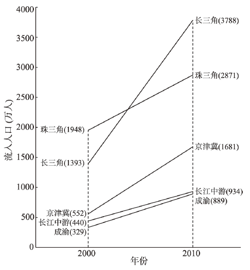
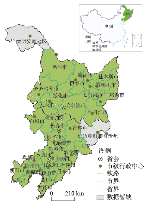
Internal migration in China has presented a series of new characteristics recently. The secondary migration and spatial redistribution of existing migrants become increasingly important in determining the future patterns of urbanization. Urban agglomerations (UAs) have long been the major destination of China's internal migration. They are also appointed as the main form of future urbanization in the recently released national planning of new-type urbanization. Five major UAs were selected as a case study, including three coastal ones, namely the Yangtze River Delta (YRD), the Pearl River Delta (PRD), and the Beijing-Tianjin-Hebei region (BTH), and two inland ones, namely the Middle Yangtze River (MYR) and the Chengdu-Chongqing (CC) region. Based on data of the latest population census and the dynamic monitoring survey of floating population in the five major UAs, this paper first examined the spatial patterns of in-migrants from multiple dimensions of destination, origin, and distance of migration. The trends and urbanization effects of migration on the destination and origin were then assessed by comparing the settlement and hukou transfer intentions of migrants with different origins and destinations. The results showed the coexistence of common and distinct features in these mega regions. Although the continuous attractiveness of central cities for migrants was observed in all regions, peripheral cities in the YRD and PRD have become increasingly attractive as well, leading to a moderately dispersing trend in these two pioneering coastal UAs. Moreover, the concentration level and spatial distribution of migrants among cities were generally stable in the YRD and PRD but continuously adjusting in the BTH and two inland UAs. The fastest growth was found in inter-county migration within province and the slowest in intra-county migration. The coastal UAs were strongly preferred by inter-provincial migrants, while the inland ones could only attract migrants from the same or surrounding provinces. Despite this, significant distance attenuation was found in all of them. In terms of the origins of migrants, those from central provinces had flowed mainly to the YRD and PRD, whereas those from the northeast showed a high preference for the BTH region. We can anticipate the future patterns of migration and urbanization from the settlement intentions of migrants from and to different cities. From the destination view, the advantage in public services made central cities considerably more attractive than other cities. Hence, they are expected to be continuously faced with severe contradiction between supply and demand of public services. In the inland UAs, however, central cities and ordinary ones are able to share the pressure of public service provision. From the original view, the high-quality and equally accessible public services are important for inland regions to attract return migrants, and providing high possibility for the return-migration-induced urbanization. However, the population loss in the northeast may become a long-term trend that can hardly be reversed in the visible future.
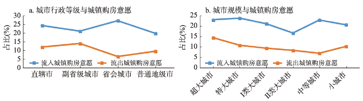
The migrants' urban housing purchase intention and its spatial preference are directly related to the path selection of the conversion of rural migrants into urban citizens and the high quality development in the new phase of urbanization. Therefore, understanding migrants' urban purchase intention and its determinants and monitoring its spatial patterns are of great importance for both academic studies and policy-making. Based on the data from the 2016 China Migrant Dynamic Survey and related statistics of cities, this paper provides an updated and comprehensive study on migrants' urban housing purchase intention in the original and destination urban areas and the determinants by using spatial autocorrelation and multi-level regression models. The results suggest that 21.62% of respondents indicated their intention of purchasing housing in the destination city; in the meantime, 11.07% of respondents expressed their intention of housing ownership in the original urban areas, and 1.68% of migrants have the housing purchase intention in both the original and destination urban areas. The research also reveals a significant variation of migrants' urban housing purchase intention among cities of different sizes, and geographical regions, demonstrating that migrants' urban housing purchase intention in the original and destination urban areas forms a complementary distribution characteristic in space. While the southeastern coastal area is the main destination of migrants in China, which is dominated by inter-provincial mobility, the urban housing purchase intention of migrants in this area belongs to the lowest categories; in contrast, its urban housing purchase intention of the original urban areas is one of the highest among different regions. However, in the migration original areas, and the areas which is dominated by intra-provincial mobility, the situation is just the opposite. The modelling results reveal that the migrants' urban housing purchase intention is mainly affected by migrants' individual characteristics and the destination city's housing market, and the level of the destination city's social and economic development has no significant effect. However, there are some important differences between the determinants of the urban housing purchase intention of the original and destination urban areas, shedding light on the variation in the factors affecting migrants' urban housing purchase intention in different urban areas. More specifically, education, occupational status of professionals and technicians, semi-family migration, family life cycle and urban housing prices have only a significant impact on the housing purchase intention in the destination cities; possessing urban houses and the number of migration motilities has only contributed to the housing purchase intention in the original urban areas; nature of household registration, occupational status of manufacturing industry personnel, mobility range, duration at host location and city size have the opposite effect in the two types of housing purchase intention. These results provide an important scientific and evidence basis for policy making to promote the further increase in migrants' urban settlement intention and its permanency and stability, which will further facilitate the advancement of China's urbanization.
Urban shrinkage is a global socio-economic phenomenon embedded in wave of economic globalization and rooted in "localization". And it has become a new proposition for Chinese geographers and urban planners to build a theoretical analysis framework of "Chinese-style" urban shrinkage research in the process of rapid urbanization and to provide Chinese experience for the study of urban shrinkage globally. In this paper, we think the essence of urban shrinkage is a response progress or status that the city's "development potential" is relative weakening or absolute degradation and caused re-location of the population-centric economic development elements and spatial reconstruction of the urban functional forms. It is a comprehensive concept, a multi-dimensional and integrated process based on the changes in population, economy, investment and consumption, and social security. And we establish the identification system and the classification criteria of urban shrinkage types based on the "two-step diagnosis method", and select the three provinces of Northeast China which are the most representative urban shrinkage regions in China to make an empirical analysis. The results show that: (1) There does exist an obvious urban shrinkage phenomenon, and the evolution trend is going to regionalization in the three provinces. And we classify the whole identified shrinkage cities into four categories: resource-dependent shrinking cities, "siphon" shrinking cities, comprehensive shrinking cities and location-constrained shrinking cities. It can be found that the resource-dependent shrinking cities are the main body, occupying 2/3 of the entire shrinking cities. (2) The spatial pattern formed by the identified shrinkage cities shows the characteristics that the number of the shrinkage cities is large in the north and small in the south, which is echoing the situation that the economic center is continuously moving from north to south. (3) From the indicator dimension, it can be found that urban shrinking wholly follows the internal evolutionary and logical connection of "investment and consumption, economic shrinkage→population shrinkage→social security shrinkage". (4) The urban shrinkage identification system and its type classification criteria based on the "two-step diagnostic method" in this paper reflect the rationality and limitations of the current urban shrinkage identification standard based on population shrinkage, although it can identify shrinking cities to a large extent, and have certain limitations in classifying shrinking city types and revealing the internal coupling mechanism of shrinking cities. (5) The empirical results confirm that the "two-step diagnosis method" of urban shrinkage is reasonable and feasible, which can provide tool support and reference basis for the identification of China's urban shrinkage and the formulation of policies for the revitalization of Northeast China.
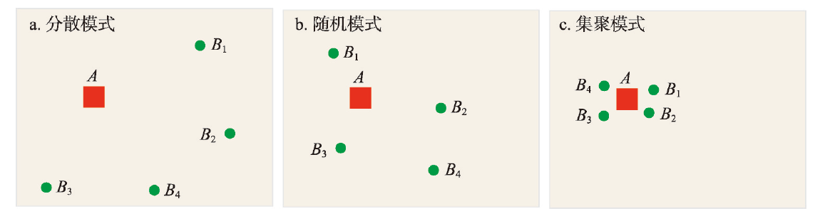
Places of employment and residence are the main spaces in which urban residents work and live, as well as key elements of the urban spatial structure. Hence, thorough investigations of the spatial correlations of office and residential buildings are of great significance for the understanding of the spatial relationships of urban elements, especially that of job-housing relationships. In this study, the objects of the research were office and residential buildings in Beijing, China, and the global and local characteristics of the spatial relationships between job-housing elements were investigated using the collaborative location quotient method. The results demonstrate that: (1) The co-location quotient, a method used to measure the spatial correlations of point elements of a survey, can be effectively applied in studies of job-housing relationships, and contributes indicators and a method for the measurement of job-housing relationships. (2) The empirical analysis reveals that the global co-location quotient (GCLQ) of office and residential buildings in Beijing is below 1, indicating relatively weak spatial correlations of the job-housing elements in the city, which is consistent with the increasing job-housing separation. Overall, residential buildings are more attracted by office buildings, suggesting that the location selection of residential buildings is affected by the local distribution of office buildings, whereas the local distribution of office buildings is barely a consideration for the location selection of residential buildings. (3) The results of the local co-location quotient (LCLQ) demonstrate that the local relationships of office and residential buildings in Beijing vary significantly in space. As the distance from the urban center increases, the LCLQ of residential buildings to office buildings decreases, while the LCLQ of office buildings to residential buildings increases. Moreover, the spatial relationships of urban job-housing elements in the north and south areas of Beijing, the dividing line of which is Chang'an Avenue, are significantly different; the spatial correlation of office and residential buildings in the north area is relatively strong, while that in the south area is relatively weak (i.e., the distribution of residential buildings is independent of that of office buildings). Additionally, the result show that the spatial relationships of office and residential buildings are related to their prices. (4) Recently, researchers have turned from studies of the urban hierarchical structure based on theories of "the space of places" to studies of the trends of "the space of flows", namely population flow, logistics flow, and information flow. This study shares a similar logic, as it investigates the urban spatial structure from the perspective of elemental correlation. This research is of great significance for the understanding of the functional zones of living, working, recreation, and transportation in cities, and relevant studies will contribute to the reasonable spatial layout of job-housing elements in urban planning.
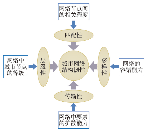
With the rapid development of information technology, the interweaving physical infrastructure and virtual urban networks show more abundant connotations. As one of the most effective indicators to measure regional resilience, urban network structure resilience focuses on the capacity of the urban network system to restore, maintain, or improve the original network characteristics and important functions when faced with external acute shock and chronic pressure. Therefore, evaluating the resilience of the urban network structure is of great significance for recognizing and understanding regional resilience. Taking 346 cities of China at the prefecture level and above as the research objects, this study constructed information, transportation, economic, and comprehensive connection networks based on the Baidu index, Tencent location services, and social statistics data. The resilience of the urban network was then measured and evaluated in four aspects: hierarchy, heterogeneity, transmissibility, and diversity. The last two properties are in interrupting simulation scenarios. Accordingly, the optimization strategies and suggestions for the network structure were put forward. Based on the results, the following conclusions can be drawn: (1) Although China's information, transportation, economic, and comprehensive networks among the 346 prefecture-level cities and above in 2017 presented a spatial pattern of "dense in the east and sparse in the west" with "Hu Huanyong Line" as the boundary, their spatial structures exhibit their own characteristics. (2) The hierarchy of information, transportation, and economic networks from strong to weak is in the following order: economic network > information network > transportation network. Large cities and provincial capital cities have a higher hierarchy in a network because of the rapid innovation and dissemination of information technology, the high development and agglomeration of industrial economy, and the rapid allocation and improvement of traffic infrastructures. (3) The three major networks of information, transportation, and economy are all heterogeneous. In the information network, there are more opportunities for cross-regional communication between high-weighted and low-weighted nodes, thereby exhibiting the highest heterogeneous resilience. (4) The transmissibility and diversity resilience of information network was slightly higher than those of the economic network and much higher than those of the transportation network. Failures or perturbations of a city have almost the same impact on network transmissibility and diversity. Cities that have a great impact on the resilience of China's urban network structure typically exhibit high centrality and control power. These cities not only have a higher level of economic development and a relatively sound transportation hub, but also exhibit superiority with regard to their geographical conditions and distribution of natural resources.
China is a large agricultural country, and issues concerning agriculture, rural areas and farmers are closely related to national economic and social development. To achieve the "Two Centenary Goals", rural revitalization strategy has become the choice to resolve unbalanced urban-rural development and inadequate rural development in China. Rural development is a comprehensive process of cycle accumulation and dynamic evolution of rural regional system. Thus, it is of great significance to systematically analyze the process and regional pattern of rural development to scientifically promote the implementation of rural revitalization strategy in the new era. Based on the theory of human-earth areal system and human-earth system science, this study examines the process and features of rural development in China from 1978 to 2050, discusses the internal relationship between rural transformation and rural revitalization, reveals the spatial pattern of the level of county rural revitalization in 2017, and finally puts forward the key problems and countermeasures for rural revitalization in the new era. Results show that the evolution of China's rural development in the period of 1978-2050 can be divided into three stages, i.e. solving the problem of food and clothing (1978-2005), building a well-off society (2005-2020) and realizing prosperity (2020-2050). In general, it is a dynamic and continuous process from low-level and basic-type to high-quality and innovation-type. Rural revitalization is a special stage of rural transformation, and a strategic choice to solve the prominent problem in rural development when it has evolved to a certain stage, thus boosting rural development to a higher stage. In 2017, when rural revitalization strategy was initiated, the level of rural revitalization in 57.3% of the counties in China was between 0.40 and 0.50, and there was an obvious gradient differentiation from the east to the west, with significant clustering characteristics and positive correlation. Specifically, the counties featured by "high-high (H-H)" clustering were mainly distributed in the third step of the terrain and the middle of Sichuan Basin; while the counties featured by "low-low (L-L)" clustering were concentrated in western China except Sichuan Basin, the eastern part of Inner Mongolia and the north of Tianshan Mountains. Due to the regionalism, stage and the difference in constraints of rural development, the focuses of rural revitalization in the new era lie in scientifically identifying the targeting areas of rural revitalization, comprehensively judging the trends of rural development, and systematically diagnosing the dominant constraints of different types of rural areas, so as to take targeted measures to make up for the shortcomings of the modernization of agriculture and rural areas. Besides, it is necessary to fully understand the interactions between urban and rural areas, thus promoting urban-rural integrated development.

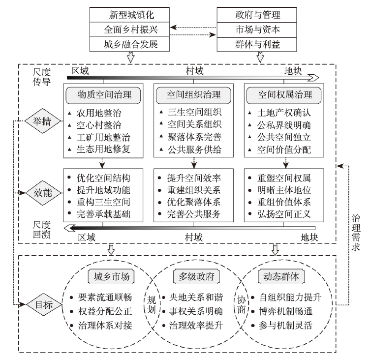
Under the background of unified management of urban and rural space, rural spatial governance has become an important part of the spatial governance system. Conducting in-depth theoretical and practical research on rural spatial governance and analyzing the mechanisms and path of rural spatial governance in national spatial planning will be conducive to improving the planning and control system of rural space. Starting from the connotation rural spatial governance, this paper constructs a theoretical analysis framework of rural spatial governance based on the comprehensive perspective of spatial governance, discusses the internal mechanism and feasible paths of rural spatial governance in territorial spatial planning, and then realizes the theoretical and practical research of rural spatial governance. The conclusions are as follows: (1) Rural spatial governance starts from the coordination theory of human-land relations in the rural regional system. Through planning and negotiation, it realizes effective control of rural space usage, and orderly allocation of space rights. Rural spatial governance highlights the comprehensive governance process that combines "top-down" and "bottom-up" participation by multiple subjects. (2) Through the "action-efficiency-target" system, the comprehensive governance analysis framework of "matter-organization-ownership" in rural space provides an effective scheme for the construction of multiple rural spatial governance that combines rigidity and flexibility, interaction between material space and space relationship, and superposition of spatial ownership and spatial organization. (3) The rural spatial governance features of interconnecting various scales (region-village-plot) are conducive to improving the rural spatial governance system. (4) The multiple governance means, participation modes and value-sharing mechanisms of rural spatial governance are conducive to enriching the territorial spatial planning system, promoting the integration of multiple regulations, refining the control of territorial space use, and ensuring good rural governance and ecological governance. (5) Rural spatial governance uses mobilization strategies of "top-down" and "bottom-up", and creates conditions for the implementation of practical village planning and revitalization strategies through the construction of new village operation models and reconstruction of organizational mechanisms.
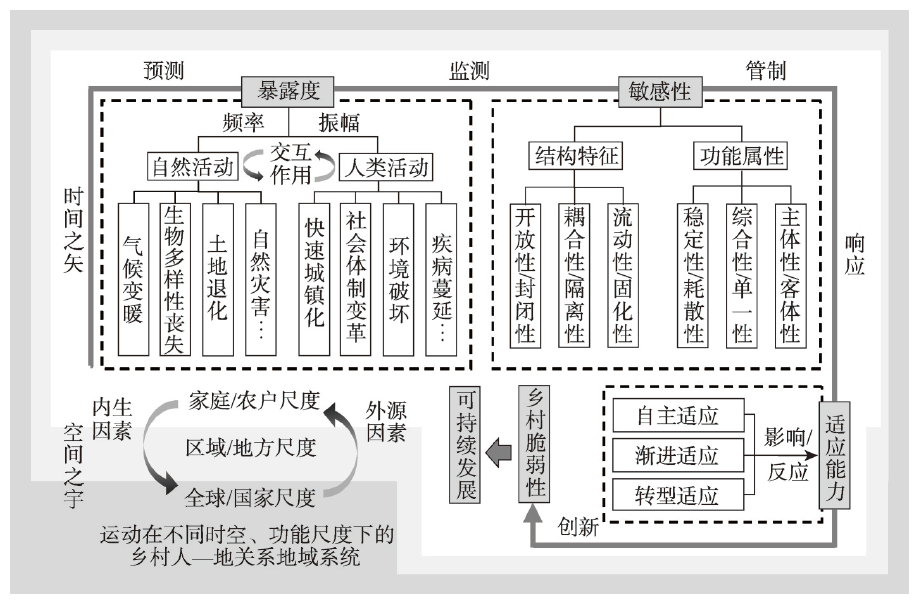
Based on the essential connotation of rural vulnerability, this study constructs an indicator system for the comprehensive measurement of rural vulnerability in China at the county level. Through the selection of five typical representative transects, we will deepen the analysis of the regional differences in China's rural vulnerability and its formation mechanism and propose targeted coping strategies. The results show that: (1) The rural vulnerability of counties in China is generally within the threshold range of low and medium vulnerability characterized by obvious spatial differences. Along the "Bole-Taipei Line", there is a spatial pattern of north-south differentiation. Villages in southwestern China tends to have higher vulnerability than those in northeastern China. (2) External environmental factors are the leading factors that induce rural vulnerability. The rural ecological subsystem, composed of ecological exposure, ecological sensitivity, and ecological adaptation, is the fundamental influencing factor of rural vulnerability. The rural economic subsystem, which is composed of economic exposure, economic sensitivity, and economic adaptation, is the core influencing factor of rural vulnerability. The social subsystem, composed of social exposure, social sensitivity, and social adaptation, is also an important factor influencing rural vulnerability. (3) On the basis of "geographical location, the dominant driving factors of rural vulnerability and the degree of rural vulnerability", rural vulnerability in China at the county level can be identified into eight categories. According to the principle of adapting measures to local conditions, we should break down the regional embeddedness and path dependence. We should strengthen the prediction and monitoring of the sources of disturbance in the rural-area system and scientifically control the sensitivity of the system itself, then improve the adaptation of the rural system to ensure sustainable development of rural areas.
China has secured a comprehensive victory in its fight against poverty. After 2020, the focus of China's battle against poverty will shift from relative poverty to absolute poverty, and from poverty in terms of income to that in other dimensions. This study applies the county as the basic unit and 31 provinces (autonomous regions/municipalities) of China as the study area. It identifies poverty levels in each county by the average night light index and the county multidimensional development index. Using the multidimensional relative poverty identification method based on the sustainable models, we analyzed the current situation of China's poverty from two aspects—multidimensional poverty and relative poverty. Finally, we explore the poverty alleviation pathways in four aspects, namely, education poverty alleviation, agricultural poverty alleviation, industrial poverty alleviation, and tourism poverty alleviation. The results revealed that nearly 60% of counties in China were primarily in multidimensional relative poverty, most of which were classified as multidimensional relatively light poverty counties. According to the average night light index and the county multidimensional development index, the numbers of poverty counties in China were 602 and 611, respectively; as of 2018, the proportions of national poverty-stricken counties accounted for 63% and 79%, respectively. The result implied that the county multidimensional development index had a more comprehensive poverty identification mechanism. Moreover, the multidimensional poverty counties were concentrated in Gansu, Sichuan, and Yunnan. Meanwhile, the development of Jilin, Liaoning, and Heilongjiang should not be overlooked. From the viewpoint of pathways, 414, 172, 442, and 298 poverty counties were suitable to industrial poverty alleviation, education poverty alleviation, tourism poverty alleviation, and agricultural poverty alleviation, respectively. Some 61% of counties had more poverty-causing factors, implying that multidimensional poverty alleviation is suitable in most of the poverty-stricken counties. These conclusions can provide a crucial scientific basis for ensuring sustainable poverty alleviation.
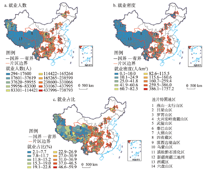
The focus of China's battle against poverty will shift from relative poverty to absolute poverty. The fundamental measure in the new stage of poverty governance is to promote transformation of destitute areas by increasing their non-farm employment opportunities and ensuring fully effective employment for the poor. Based on county data from 2013 to 2017 covering 14 contiguous destitute areas of China, the spatial econometric model method was adopted to analyze the spatial growth trend of non-farm employment in these areas and its driving factors since the implementation of the poverty alleviation strategy, and the differences in the drivers of non-farm employment under different population sizes were distinguished. The results were obtained as follows: (1) Non-farm employment exhibits a strong spatial non-equilibrium. (2) The growth of non-farm employment is faster than the national average, with apparent characteristics of spatial heterogeneity and clear tendencies of convergence. (3) There is substantial spatial dependence on the growth of non-farm employment among counties in the study areas. Place-based factors and geo-structural factors have jointly affected the growth of non-farm employment in these areas. The level of initial employment has a restraining effect on non-farm employment growth. However, the regional economic scales, the availability of financial capital, the industrial structure, the level of basic education, the proximity of market to provincial capitals or megacities, and the flat or humid geographical environments have significantly contributed to the growth of non-farm employment in destitute areas. (4) The determinants of non-farm employment growth in counties at different scales have significant differences. This research provides support to further research on the growth of non-farm employment in poor areas as well as poverty governance and regional transformation and development in the new period.
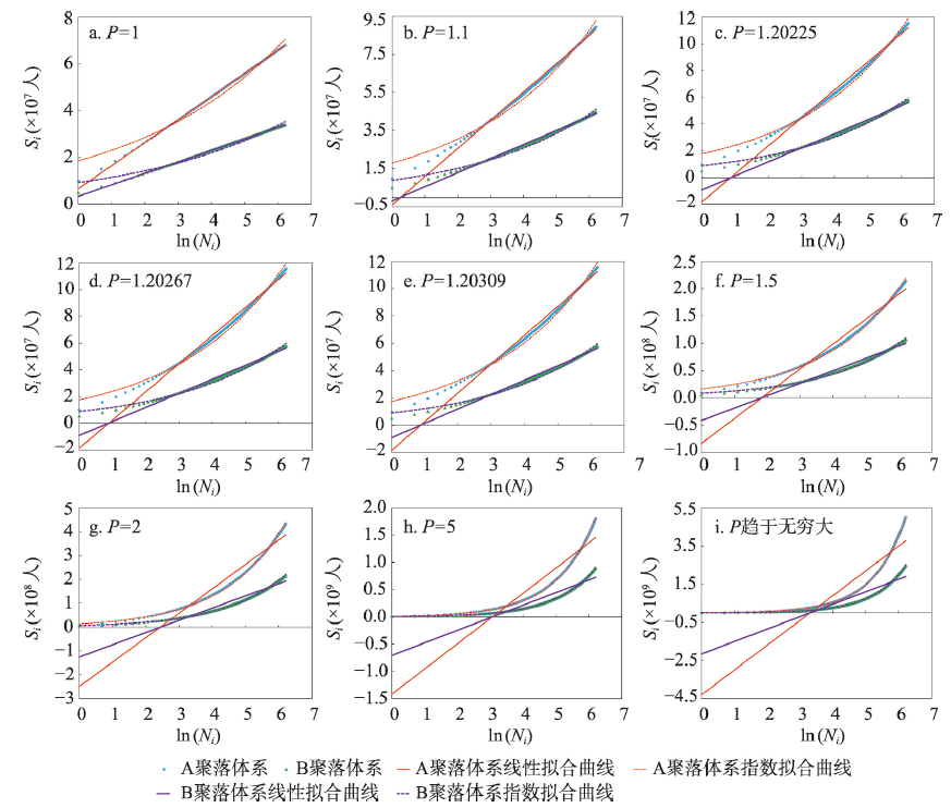
Scientific determination of rural settlement system is one of the keys to implement the strategy of rural revitalization and promote the modernization of agriculture and rural areas. Meanwhile, understanding the distribution law of rural settlement size is helpful for the optimization of rural settlements. In order to provide a reliable theoretical basis for the study of rural settlement size distribution and the optimization of rural settlement system, this article took the Hehuang area as an example, and explored a more accurate expression and law of Rank Cumulative Size Model based on the original Rank Cumulative Size Model. Then we examined the applicability and accuracy of the model in rural settlement size distribution compared with the Rural Rank-Size Rule. We also studied the characteristics and evolution law of rural settlement size distribution in the study area. The results show that: (1) Rank Cumulative Size Model is a monotonously increasing concave function (P ≥ 1), and its expression varies with the change of the Pareto coefficient of rural settlements. When 1 ≤ P < 1.20225, Si = aln(Ni) + b, there is a positive correlation between the fitting coefficient a and the size of first settlements. When P ≥ 1.20225, $S_i=be^{aln(N_i)}$ the coefficient of variation of settlement size and the size of the first settlements are negatively correlated with the fitting coefficient a, and positively correlated with the fitting coefficient b. (2) Rank Cumulative Size Model is more suitable for the study of rural settlement size distribution in Hehuang as it has better applicability and accuracy; while the Rural Rank-size Rule is not applicable. (3) The rural settlement size in Hehuang nearly shows the equilibrium distribution pattern of Pareto coefficient 2 and tends to be more concentrated. In the future, the rural settlements should be concentrated in areas with superior natural and socio-economic conditions, and the layout of regional rural settlements and villages should be planned reasonably. Based on this, we can develop a rural revitalization path with the harmonious coexistence between human and nature, as well as between urban and rural development.
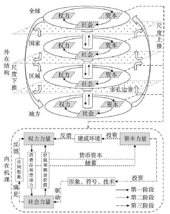
With the rapid development of urbanization and national economy in China, tourism is becoming an important factor and momentum of social and economic development. Tourism constantly reconstructs the spatial form of China's tourist destinations and surrounding regions, and promotes the connection between global and local forces in the space of tourist destinations. Tourist destinations are a special regional spatial system. Globalization and localization are important forces to promote tourist destination evolution, which have dialectical and unified logical relationships. Existing studies on tourism destination evolution have paid little attention to the important paradigms of modern Western human geography, such as structuralism. Based on the holistic research perspective of glocalization, this paper constructs a conceptual framework and makes research prospects, aiming at providing theoretical basis and practical paths for the follow-up study of tourism destination evolution. The research concludes that the theory of glocalization has a good applicability in the study of tourism destination evolution, which provides a theoretical foundation for tourism destination evolution based on the external structure and internal mechanism. The process and mechanism of tourism destination evolution are related to various aspects of social and economic development in China according to the theory of global localization, which broadens the research thinking of the traditional proposition of tourism destination evolution. From the perspective of glocalization, the spatial pattern research of multi-scale, multi-region and multi-type is a specific way to examine the tourist destination evolution, and it provides a practical scheme for the systematic study of tourist destination evolution in China. Tourist destination evolution in the glocalization perspective corresponds to the spatial and temporal evolution of man-land relationship in China, and provides ideas for the transformation and innovation of the research paradigm of tourism geography in China.
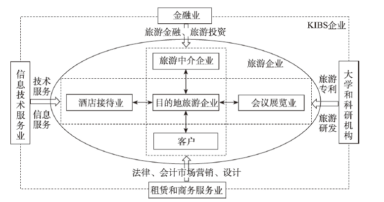
Knowledge-intensive business services (KIBS), as a key component of the national innovation system (NIS), has become a crucial driving factor for the regional tourism innovation. Despite ever-increasing overlapping and interaction between tourism and KIBS, there was little literature on the relations of KIBS clustering and regional tourism innovation. In this paper, the authors measured the clustering level of KIBS and total factor productivity (TFP) of regional tourism innovation in China's three mega-city regions (MCR), namely, the Yangtze River Delta (YRD), the Pearl River Delta (PRD), and the Beijing-Tianjin-Hebei (BTH) urban agglomeration, using the methods of location quotient and data envelopment analysis. Then, the authors examined the spatial distribution and cluster mode of regional tourism innovation TFP in the three MCRs using the spatial data analysis method (ESDA). Finally, the authors evaluated the impact and spatial effect of KIBS clustering, among other factors, on regional tourism innovation on the basis of the panel data (from 2005 to 2015) and Spatial Panel Durbin Model (SPDM). The results show that: (1) KIBS in all the three MCRs show high levels of clustering, though the intensity of clustering exhibits a descending pattern from the PRD, to the YRD, and to the BTH. KIBS clustering mainly takes place in municipalities directly under the central government and first-tier cities to the provincial capitals, with significant regional differences among different cities in these MCRs. (2) The regional tourism innovation TFPs in the three MCRs from high to low are the YRD (1.006), the PRD (0.978), and the BTH (0.960), and the changes in TFP are mainly due to technological advancement. (3) Among the three MCRs, only the YRD shows a significant level of spatial clustering of regional tourism innovation on a global scale, while there have been certain signs of spatial clustering in each of the three MCRs on a local scale. However, different MCRs show different spatial clustering patterns: spatial clustering in most cities in the YRD is in the high-low type, while that in most cities in the PRD and BTH region is in the high-low and low-high types. (4) Despite variations from region to region, KIBS clustering has a positive effect on the level of regional tourism innovation. There have been effects of spatial spillover in all the three MCRs, however, it is necessary to set good examples and create favorable conditions for neighbouring cities. (5) An open policy system and well-paced marketization have a promoting effect on regional tourism innovation TFP. The optimization of industrial structure and improvement in digitalization also plays a positive role in regional tourism innovation, which is the result of multiple innovation factors.
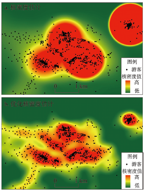
It is of great significance for tourism research to extract the spatial boundary of tourist activity, especially for optimizing the spatial structure of scenic spots, implementing boundary control and improving the utilization efficiency. Due to the complexity of tourist activity, it is difficult to identify the spatial boundary of tourist activity by using traditional method effectively. The study uses optimized Delaunay triangulation based on hierarchical clustering algorithm (ASCDT), instead of the points feature, which is dedicated to solving the problem of inaccurate spatial fitting in kernel density estimation at multi-scale. We analyze the spatial aggregation characteristic of tourist activity, and build the hierarchy based on concentric zone theory. Then we analyze the relations in geographic factors by using lots of spatiotemporal sign-in data, and propose a novel method for extracting the boundary of tourist activity, which is called "Hie-Density". "Hie-Density" is based on the spatial law of the expanding distribution. The study explores the macroscopic system evolution by the interaction of circle subsystems, and proves that "Hie-Density" can be used to discuss the multiple distribution patterns of spatial activity. According to the law of deviation in curve, it is easy to identify the optimal spatial boundary of tourist activity, the state of spatial aggregation, the characteristic of central splitting and the evolution direction of the spatial boundary. The cases show that the method is applicable to the complex spatial distribution structure. The study involves different kinds of scenic spots at multi-scales, so as to provide a new perspective and a novel method for geographical spatiotemporal data mining.
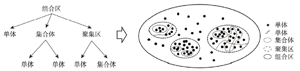
Tourism resources are the material condition for tourism development and the carrier and foundation of various tourism activities. In the last few years, great progress has been made in classification methods and evaluation theories for tourism resources. However, in the investigation and planning of tourism resources, scenic areas or large-scale geographic entities and small-scale entities are usually measured and compared under the same standard, without considering the spatial scale of tourism resources. For different scales of tourism geographic entities, the evaluation and planning of tourism resources are conducted using different methods. This paper proposes to identify the aggregation of tourism resources by grooming spatial units of tourism resources with different scales. Based on the concept cognition of tourism resource aggregation, we constructed an ontological model by establishing the spatial semantic relation and proposed a method to extract the spatial extent of tourism resource aggregation and classify its types. We chose Hainan Island as a case study to conduct empirical studies, construct three different types of tourism resource ontology using spatial semantics, and investigate spatial recognition in tourism resource aggregation using the Tyson polygon and buffer analysis methods. The results show that the approach can be widely applied to approximate the spatial boundary and relation of tourism resource aggregation, and the spatial semantic relationship of each type of aggregation is characterized by a tree-like hierarchical structure consisting of two levels, namely, polygonal and band-shaped spatial shapes. The spatial structure belongs to a composite landscape, which is mostly represented by the combination of mountains and water or mountains, water and biological landscape. This research method can provide a scientific basis for tourism planning and management.