Water resources in China are unevenly distributed in time and space, which mismatches with China's economic and social patterns. The water situations severely restrict China's sustainable development. There are many problems in the present river and lake systems in China, mainly including frequent occurrences of flood and waterlogging, water shortage, river and lake shrinkage, severe water pollution, and water ecology and environment degeneration. It is one of the key subjects to protect water resources in China's economic and social developments. China's water conservancy development strategy is to actively propel the establishment of the interconnected river system network (IRSN), improve the ability of water resources allocation, guarantee river and lake health, and control floods and droughts. It is of significance to conduct research on the theories and techniques of IRSN. This paper mainly analyzed the situation of water resources that faces China, and then discussed the necessity and urgency of IRSN, proposed the key scientific issues of IRSN, and prospected the research framework for solving the relevant issues.
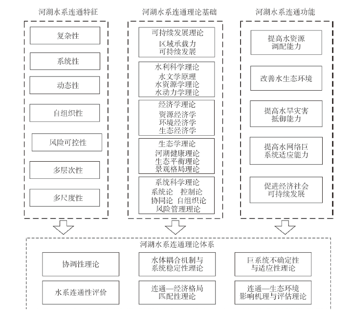
The interconnected river system network (IRSN), as an important strategy of national water security, is actively promoted in China. There are great significances to improve the ability of water resources allocation, guarantee river and lake health, and control floods and droughts. A large number of IRSN practical projects have been built to bring huge benefits, but they are facing risks such as ecologic and environmental deteoriation, water shortage and economic loss. Therefore, we need theoretical systems as the guidance to achieve more eco-economic comprehensive benefits from IRSN in the future. However, the theories of IRSN, are just rare and fractional, far from a complete system. It is urgent to promote the theoretical construction based on the relevant scientific theories. This paper firstly discussed the systemic and interdisciplinary characteristics of the theories of IRSN, and then analyzed the relationship between the IRSN theories and some main relevant scientific theories including the sustainable development theory, hydrology theories, hydrodynamics theories, economics theories, ecological theory and system science theory, which were thought to helpfully provide the valuable theoretical basis for IRSN. The IRSN theories system should be built and innovated on the basis of the comprehensive systems of these relevant scientific theories. Considering the urgent demands for the operation of IRSN, the theory research in some priority areas should been done, such as the theory and methods of the IRSN connectivity and function assessment, the theory of the IRSN coupling mechanism and system stability, the theory of the IRSN compatibility, the theory of matching of the IRSN and economic pattern, the theory of the IRSN impact mechanism and evaluation on ecological environment, the theory of the uncertainty and adaptability of IRSN giant systems. All these theories and some priority areas of the IRSN theory systems would provide a strong support for the IRSN projects implementation and benefits.
It is predicted that many regions will witness higher frequencies of drought events under global climate change, which could pose a threat to crop yield and water security. Therefore, the development of efficient and reliable methods for agricultural drought prediction is crucial. This study used the Standardized Precipitation Index (SPI) based on monthly precipitation at a 6-month time scale as an indicator of meteorological drought. The Joint Standardized Soil Moisture Index (JSSI) was used to assess the comprehensive situation of agricultural drought and was derived by combining the Standardized Soil Moisture Index (SSI) over 1-, 3-, 6-, 9-, and 12-month time scales based on monthly root zone soil moisture. Using the antecedent SPI and the persistent JSSI as predictors, the Meta-Gaussian (MG) model was applied to predict agricultural drought in China from June to August in 1961-2015. The Brier Skill Score (BSS) and Nash-Sutcliffe Efficiency Coefficient (NSE) were adopted for the evaluation of the prediction performance of the MG model. The results showed that the JSSI was capable of capturing both emerging and prolonged agricultural droughts in a timely manner, which is significant for agricultural drought monitoring. The spatial distribution of predictions of severe agricultural droughts with the 1- to 3-month lead by the JSSI for June to August in 2010 and 2014 resembled the corresponding observations for most parts of China. Moreover, the areas with a predicted higher probability of JSSI falling below -0.5 corresponded well with areas that experienced agricultural drought according to observed data (JSSI < -0.5). The BSS and NSE results confirmed that the MG model was able to provide reliable predictions of agricultural drought for June to August in most parts of China. The prediction of JSSI from June to August by the MG model with the 1-month lead showed that the proportions of the total area with BSS ≥ 0.5 were 0.714, 0.642, and 0.640, respectively, whereas the proportions of the total area with NSE ≥ 0.5 were 0.903, 0.829, and 0.837, respectively. However, the MG model performed poorly in desert areas, including southern Xinjiang, western Qinghai and western Inner Mongolia, which may have been due to the extremely arid conditions of these regions with soil water mostly related to condensation water rather than rainfall. The results of this study can provide scientific basis for agricultural drought monitoring, early warning, and decision-making in China.

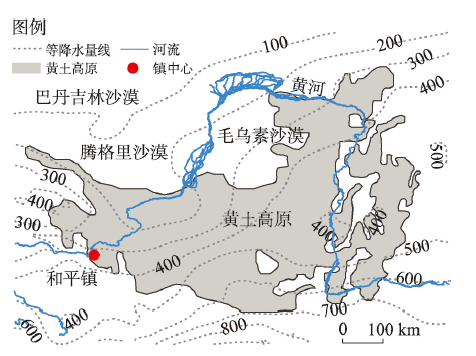
Climate change since the last deglaciation period is an important topic of Quaternary paleoclimate research. Eolian Holocene paleosols (S0) and last glacial loess (L1) on the western Loess Plateau margin have high sedimentation rates and provide valuable materials for the study of East Asian monsoon climate change since the last glacial deglaciation. Here we report high-resolution environmental magnetic records spanning the last 16 ka for the whole S0 and the uppermost L1 from the Hepingzhen section in the western Chinese Loess Plateau. Environmental magnetic results suggest that the magnetic properties of the Hepingzhen loess section are dominated by fine-grained magnetite, including superparamagnetic (SP), single-domain (SD), and fine pseudo single-domain (PSD) magnetite particles. The magnetic susceptibility and frequency dependent magnetic susceptibility records show identical variability during the last 16 ka. This consistent variability suggests that they are both influenced by content of pedogenic fine-grained (SP, SD, and fine PSD) magnetite particles, which is similar to the loess accumulations on the eastern Chinese Loess Plateau. Therefore, the magnetic susceptibility and frequency dependent magnetic susceptibility records of the Hepingzhen loess section can be also used to infer the soil pedogenic intensity and summer monsoon precipitation that dominates regional pedogenesis, as the case for the eastern Chinese Loess Plateau. The summer monsoon rainfall variation inferred from the Hepingzhen loess magnetic susceptibility and frequency dependent magnetic susceptibility records is consistent with that inferred from South China stalagmite oxygen isotope data during the last 16 ka. Both the western Chinese Loess Plateau and South China precipitation is suggested to be substantially lower during the last glacial period than in the Holocene. Precipitation was high during the BØlling-AllerØd Warming (BA, 15-13 ka BP), and low during the Younger Dryas (YD, ~12 ka BP). The highest precipitation occurred in the early Holocene (~11 ka BP), with a long-term decreasing trend from early to late Holocene. Combining a detailed land-sea comparison, we suggest that the variation of East Asian monsoon precipitation between 16 ka and 11 ka was affected by combined solar radiation and regional temperature of the northern hemisphere, while the long-term summer monsoon precipitation during the last 11 ka was dominated by a decreasing trend in solar radiation.
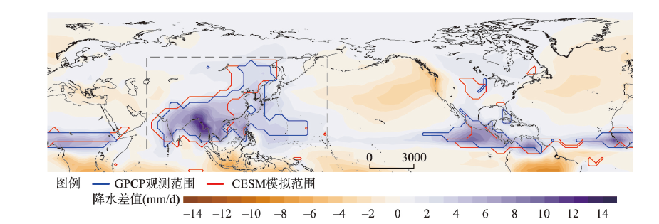
Asian summer monsoon (ASM), one of the key elements of the global climate system, strongly affects food production and security of most people over Asia. However, the characteristics and the forcing drivers of the ASM system at decadal to centennial time scales remain unclear. To address these issues, we report four 1500-a long climate model simulations based on the Community Earth System Model (CESM), including full-forced run (ALLR), control run (CTRL), natural run (NAT), and anthropogenic run (ANTH). After evaluating the performances of the CESM in simulating ASM precipitation, a 10-100 bandpass filter is applied to obtain the decadal-centennial signals in ASM precipitation. The main conclusions are as follows: (1) the variation of ASM intensity shows significant decadal to centennial periodicities in the ALLR, such as ~15, ~25, ~40 and ~70 years. (2) The major spatial-temporal distributions of ASM precipitation in the ALLR show an external forced mode and a climate internal variability mode. (3) The leading forced mode of ASM precipitation is mainly affected by natural forcing over the past 1500 years and characterizes a meridional spatial 'triple' mode. In the NAT (solar irradiation and volcanic eruptions), the substantial warming (cooling) over the western tropical Pacific enhances (or reduces) the SST gradient change in the tropical Pacific and modifies the ASM rainfall distribution. Our findings contribute to a better understanding of the ASM in the past and provide implications for future projections of the ASM under global warming.
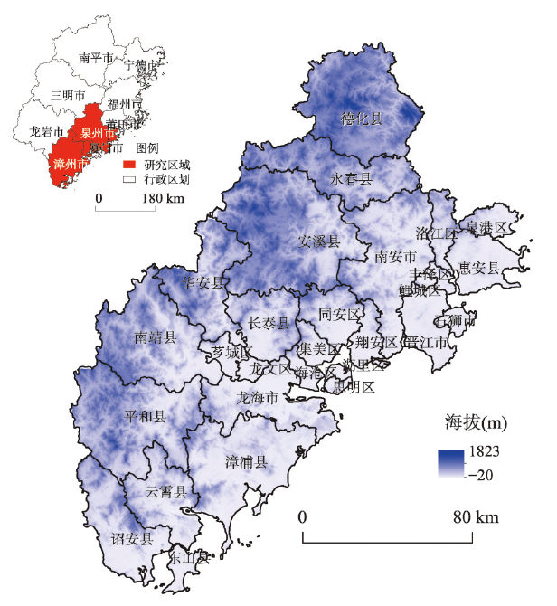
Exploring the influence mechanism of expansion for urban areas on thermal environment is significant for improving urban ecological environment. In this study, nighttime light (NTL) can be regarded as an evidence of urban development. Based on Landsat remote sensing data, DMSP/OLS nighttime light data and NPP/VIIRS nighttime light data of Xiamen, Zhangzhou and Quanzhou in southern Fujian during 1996-2017, this study applied the overall coupling model and coordination model to discuss the spatio-temporal coupling and coordination relationship between urban development and land surface temperature (LST) distribution. Additionally, the spatial response law was analyzed by standard deviation ellipse, bivariate spatial autocorrelation and landscape index. The results show that during 1996-2017, the spatial distribution patterns of LST and NTL show that urban development is closely related with factors such as geographical location and terrain. In the western inland areas with high elevations, forests are obviously concentrated with relatively low LST, while in the eastern plain areas, more urban areas are distributed with relatively high LST. In the three cities, the overall coupling situation of NTL and LST is constantly strengthening, and the proportion of coordination for NTL and LST is gradually increasing. In the early stage of urban development, the influence of NTL on LST is hysteretic. In the late stage, the influence of NTL on LST is in advance. There is a positive correlation between NTL and LST, and a spatial spillover effect is obvious. The correlation coefficient and bivariate spatial autocorrelation Moran's I value gradually increase, indicating that NTL has an increasing influence on the change of LST. The HH (High-High)-type and LL (Low-Low)-type agglomeration areas continue to expand. Influenced by the trend of integrated development of the three study cities, HH-type agglomeration area is gradually concentrated in regions connecting the cities, such as Xiamen, Jinjiang, Shishi and central urban area of Zhangzhou. The influence of urban development on LST is related to the development condition of itself. Compared with Zhangzhou and Quanzhou, NTL has a more significant influence on the LST in Xiamen. The study results provide a scientific guidance for the optimization of thermal environment in the three cities of southern Fujian.
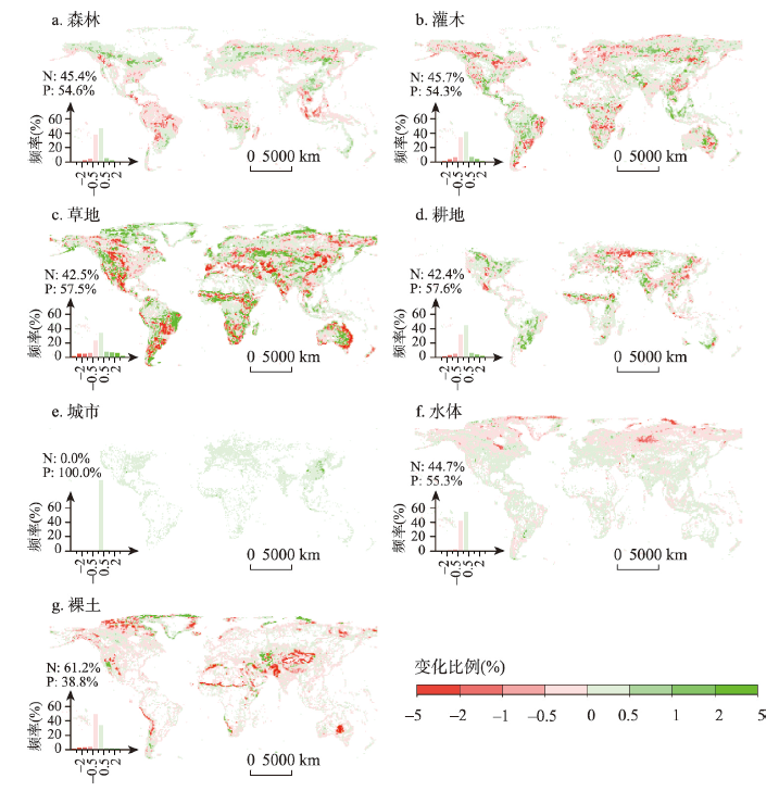
Evapotranspiration is a key variable and key process in global water cycle, and it is crucial for understanding how anthropogenic and climate changes have impacts on terrestrial water cycle. In the last decade, global vegetation changes are dramatic, reflected by land use and land cover changes and increase in leaf area index. It remains unclear how these changes influence terrestrial evapotranspiration processes. This study uses a coupled evapotranspiration and gross primary product model (PML-V2) that is run at 500 m and 8-day resolutions across the globe to investigate the impacts of vegetation changes on spatial pattern and dynamics of evapotranspiration in the period of 2003-2017. We found that evapotranspiration across the globe has increased noticeably because of vegetation changes, which is characterized by clear regional and non-regional patterns. Transpiration has strongly increased in the central and northern parts of North America, Europe, eastern China, southern Africa, and eastern and northern Australia. Under different land cover types, shrubs and cropland have been influenced strongly, and their impact is stronger in the post-2012 period than that in the pre-2012 period. The recent total increase from these two land cover types amounts to about 0.41 ×10³ km3 a-1, which is about 8 times of natural annual runoff from the Yellow River Basin. The results from this study can help improve the understanding of how vegetation changes caused by recent land use and land cover changes influence terrestrial water cycle and the potential local and regional climate change.
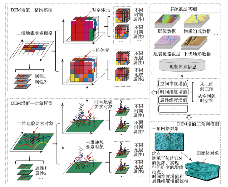
Digital terrain analysis (DTA) is one of the most important contents of research on geographical information science (GIS). However, when a digital elevation model (DEM) is used, many problems arise in DTA geomorphological studies. For instance, current DTA research focused on morphology, phenomenon and modern surface rather than the mechanism, process and underlying terrain. Thus, current DTA research needs to be transformed from the study of landform morphology to the study of landform process and mechanism. On this basis, this study summarised the current research status of geomorphology-oriented DTA and systematically reviewed and analysed the research on geomorphology, terrain modelling, terrain derivative calculation and other terrain analysis methods. The investigated studies showed that with the help of DEM data, DTA research has the advantage of carrying out geomorphology studies from the perspective of surface morphology. However, DTA research has inherent defects in data expression and analysis patterns. Thus, breakthroughs must be achieved in basic theories and key technologies to transform DTA research from phenomenon to mechanism, from morphology to process and from terrain to landform. At present, the development of research on earth science has reached a critical stage wherein DTA research should focus on the discussion of geomorphology. This study proposes several prospects of geomorphology-oriented DTA from the aspects of value-added DEM, terrain derivatives and their spatial relations and macro-terrain analysis. The study of DTA by using DEM is at a critical period along with the issue on whether the current GIS technology can truly support the development of geography. The research idea of geomorphology-oriented DTA is expected to be an important area of exploration and practice in GIS.
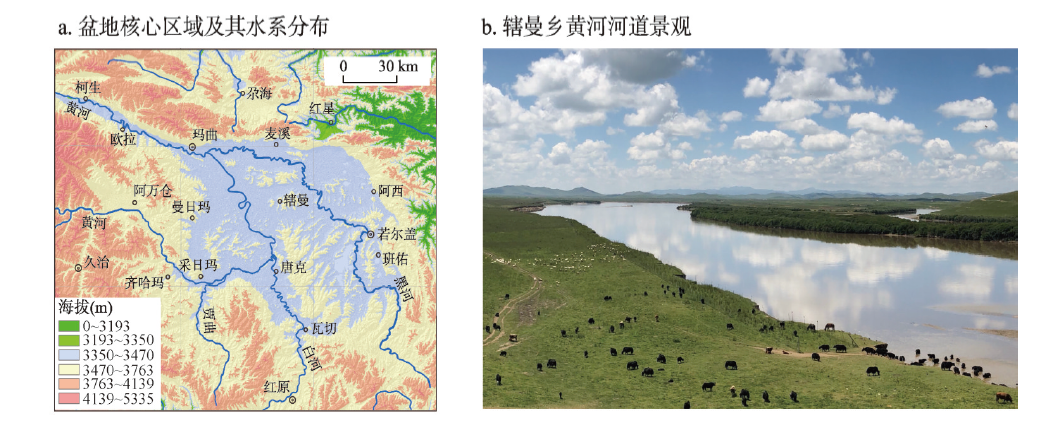
The lake environment in the Zoige Basin of the Tibetan Plateau persisted for a long time in the Quaternary. It represents a great turning point of environmental change over the eastern Tibetan Plateau when the basin was dissected, the lake disappeared and the Yellow River course formed. The ages of these important events are very complicated and therefore still controversial, which requires further research and discussion. This paper provides an overall review and perspective of these issues. An in-depth study of the accumulation of the palaeoflood deposits, chronology and hydrology will facilitate the establishment of a continuous sequence of palaeoflood events of the Yellow River on the Zoige Basin. The direct evidence of the extinction of the palaeo-lake and the appearance of the course of the Yellow River drainage basin will be obtained by identification of the stratigraphic unconformity between the earliest palaeoflood deposit and the palaeo-lake deposit. The age of these remarkable events can be achieved by using AMS- 14C and OSL dating methods. In combination with the analysis of environmental change, especially the evolution of geomorphology and hydro-climatology, this paper reveals the mechanisms of the dissection and the formation of the Yellow River course, and the disappearance of the palaeo-lake. Our latest investigation indicates that extraordinary palaeoflood events occurred during OSL age 13590±1200 a to 12980±1090 a along the Maqu reach of the Yellow River in the downstream of the Zoige Basin. The floodwater came from the melting of mountain glaciers surrounding the basin during the Bolling-Allerod warm phase of the last deglacition. This means that the palaeo-lake had disappeared and the course of the Yellow River had formed through the Zoige Basin. These results are of great significance in understanding the formation of the Yellow River course, and enriching the theory of environmental evolution over the Tibetan Plateau.
Explicitly identifying the ecotone distribution and scenario change is of important significance to understand the response of ecosystem to climatic change. In this paper, a spatial identification method was developed to analyze the ecotone distribution in terms of the improved Holdridge life zone (iHLZ) model. Based on the climatic observation data of 782 weather stations of China in the T0 (1981-2010) period, and the climatic scenario data of IPCC CMIP5 RCP2.6, RCP4.5 and RCP8.5 in T1 (2011-2040), T2 (2041-2070) and T3 (2071-2100), the ecotones distribution and scenarios in China were simulated in the four periods. Moreover, a spatial shift trend model of mean center was introduced to quantitatively calculate the shift direction and distance of each ecotone type during the periods from T0 to T3. The simulated results show that there are 41 ecotone types in China, accounting for 18% of the total land area of China. The ecotones of cold temperate grassland / humid forest and warm temperate arid forest (564238.5 km2), cold temperate humid forest and warm temperate arid / humid forest (566549.75 km2), and northern humid / humid forest and cold temperate humid forest (525750.25 km2) are the main ecotone types, accounting for 35% of the total area of ecotones in China. Between T0 and T3, the area in the ecotone of cold temperate desert shrub and warm temperate desert shrub / thorn steppe will increase at a rate of 4% per decade, which is up by 3604.2, 10063.1 and 17242 km2 per decade under the RCP2.6, RCP4.5 and RCP8.5 scenarios, respectively. The cold ecotones will transform to the warm humid ecotones in the future. The average shift distance of mean center in the ecotone of north wet forest and cold temperate desert shrub / thorn grassland will be generally larger than that of other ecotones, whose mean center will move to the northeast, and the shift distance will be more than 150 km between T0 and T3. In addition, with a gradual increase of temperature and precipitation, the ecotones in northern China will show a shifting northward trend, while the ecotones in southern China will decrease gradually, and their mean center move to the high-altitude areas. The effects of climate change on ecotones will show an increasing trend in China, especially in the Qinghai-Tibet Plateau.
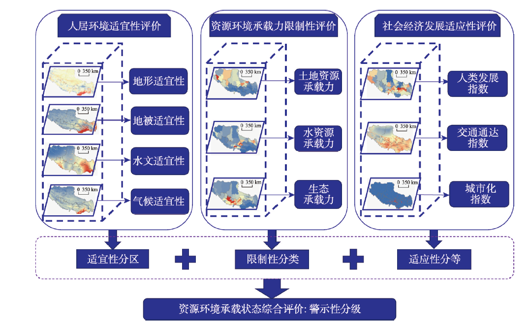
Quantitative evaluation and comprehensive measurement of resource and environmental carrying capacity are the technical keys in the research of resource and environmental carrying capacity from classification to synthesis. From a system perspective, this paper proposes a three-dimensional tetrahedron model with physical meaning to comprehensively evaluate resource and environmental carrying capacity, which is conducted on the structure of "human settlement environment suitability classification - resource and environmental carrying capacity restrictive classification - socioeconomic development adaptability classification - resource and environmental carrying capacity warning classification". Its results have clear policy guidance significance for the establishment of the dynamic-monitoring and early-warning mechanism for regional resource and environmental carrying capacity. Based on the above methods, this research, taking Tibet Autonomous Region as an example and using 1-km gridded data, quantitatively assessed regional resource and environmental carrying capacity at county level. The results show that there were about 3/4 areas in good condition of resources and environmental carrying status (surplus or balanced state), with more than 4/5 of population; the human settlement environment in Tibet was mainly characterized by unsuitability and critical suitability, while the socioeconomic development level there generally lagged behind. Within this context, we suggest that human settlement environment suitability and socioeconomic development level have greatly restricted the performance and improvement of resource and environmental carrying capacity in Tibet.
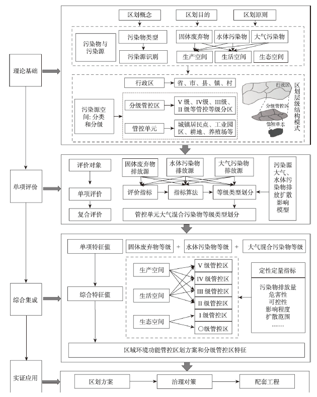
Environmental governance plays a pivotal role in promoting the high-quality development of environment, and the implementation of source control and zoning management is the foundation of the refined governance of environmental space. This paper aims to put forward the theoretical and technical methods of regional environmental function management and control zoning, and carry out an empirical study on Shengzhou city, Zhejiang province. First, a spatial structure model of the environmental pollution sources (EPSs) for human activities, which is composed of control units (CUs) and hierarchical control areas (HCAs), has been formed and identified. Then, the solid waste, air pollutants and water pollutants are selected as the main pollutants, and the single evaluation and weighted sum have been measured for each CU. Finally, according to the spatial classification of the CUs and the integrated eigenvalues, key countermeasures and supporting projects of each HCA are proposed. The main results are as follows: (1) Shengzhou city has a total of 18 CUs, which can be divided into 6 HCAs. HACs of levels Ⅴ and Ⅳ are the areas where pollutants are discharged intensively, with integrated eigenvalues of 11 and 10 respectively. The CUs, including refuse landfill, sewage-treatment plant, high-pollution industrial zone, livestock and poultry farm, mining area, and basic industrial zone, have hugh impact on water and atmosphere, and have great hazards. It is necessary to promote the resource utilization of industrial and mining production space in the key area of environmental governance. (2) The emissions of pollutants in the HACs of levels Ⅲ and Ⅱ are medium or even less. The CUs of level-Ⅲ HAC cover urban settlements, rural settlements and transportation land, with integrated eigenvalues of 6 and 7. It is important to improve the collection and treatment technology of solid waste and sewage in all living space. In addition, HAC of level-Ⅱ includes two CUs, which are cultivated land and garden plot, with integrated eigenvalues of 4. It has a small amount of agricultural solid waste and sewage discharge, therefore, it is urgent to solve the problems of non-point source pollution and eutrophication. (3) HACs of level-Ⅰ is composed of forest land, garden land, water area, bare land and other ecological space, with more emphasis on ecological protection function. Large scale industrialization and urbanization are prohibited in the area. HAC of level 〇 highly overlaps ecological redline, which requires complete prohibition of human activities and the elimination of external environmental impact.
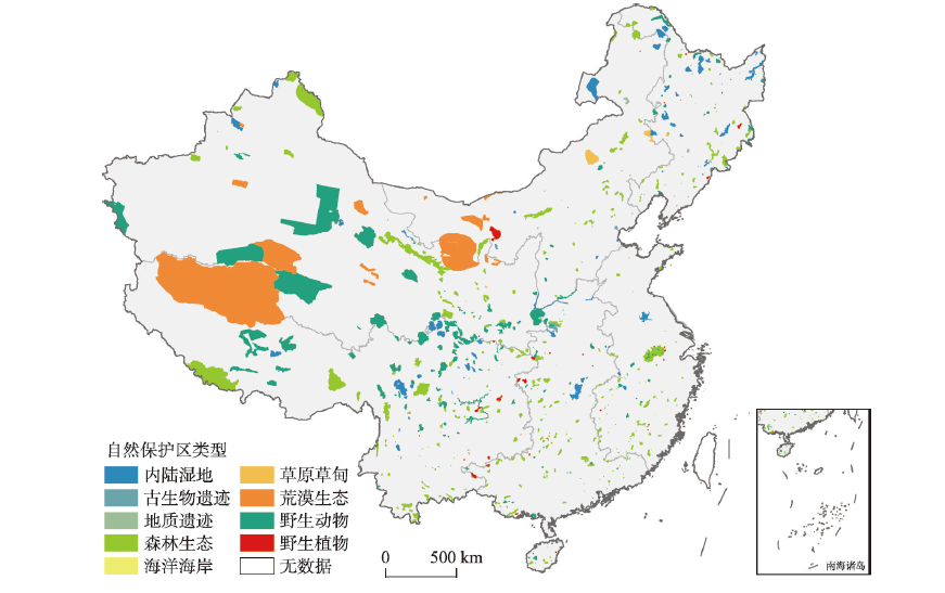
Assessing the effectiveness of nature reserves for mitigating anthropogenic pressures is essential for effective nature protection. The current research at national scale in China only compares anthropogenic pressures inside nature reserves to that outside, but fails to solve the problem of sample selection deviation, which will lead to bias in assessment results. In order to solve this problem, we adopted propensity score matching method to improve the accuracy of the results in the evaluation of nature reserves. The multi-source data were firstly integrated to build Anthropogenic Pressure Index in 2013, 2015, and 2017, then the propensity score matching method was applied to match the random points inside and outside the nature reserves, to make sure that the observed variables of the two comparison groups were as similar as possible. Finally, we used relative effectiveness indicator and panel model to assess the effectiveness of 680 nature reserves in China for mitigating anthropogenic pressures from 2013 to 2017 at different levels. The results show that: (1) From 2013 to 2017, 86.72% of China's nature reserves experienced a positive trend of anthropogenic pressures, which accounted for 43.80% of the total area. (2) Some 69.85% of nature reserves performed well in mitigating anthropogenic pressures. Except for marine coasts, wild plants, and wild animals, the types of nature reserves were under sound protection, and the higher the level of nature reserves, the better the protection effectiveness. (3) From 2013 to 2017, anthropogenic pressures were mitigated by 22.90% by the construction of China's nature reserves, and there were regional differences regarding the degree of mitigation. The results can provide a more scientific reference for future monitoring, assessment and management of nature reserves in China.
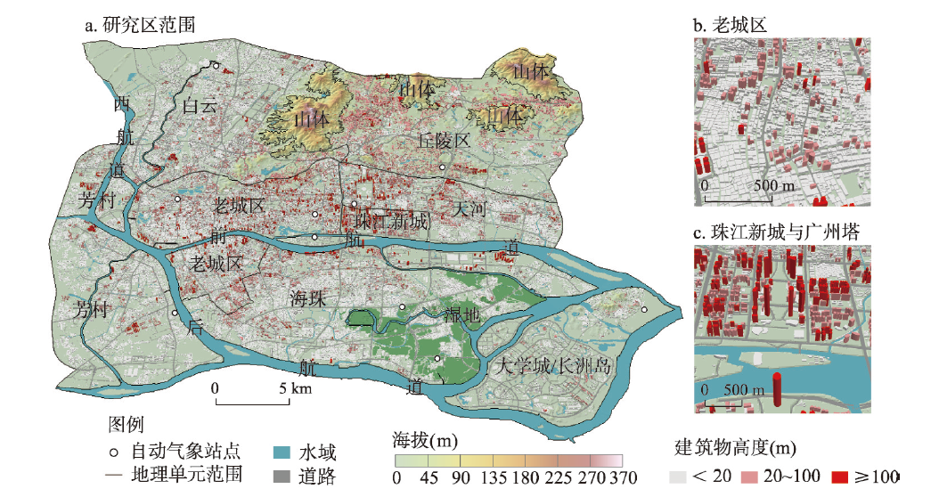
This paper attempts to explore the feature and efficiency of the ventilation channel in the main built-up area of Guangzhou, one of the four first-tier cities in China. Building groups were simplified and then the centerlines of open areas were sketched out, and finally proceeded to the identification of the ventilation channels. Data of hourly wind direction and velocity of the year 2016 were used. Indicators based on GIS for measuring the physical and thermal properties of ventilation channels were proposed, which facilitate the analysis of the characteristics of the ventilation channels and the evaluation of their efficiency. The results show that: (1) There are 2451 potential ventilation channel centerlines at a 40-m resolution, when composed, 142 meet the standard of ventilation channel. The total ventilation area reached 96.49 km2, accounting for 21.59% of the study area. (2) Centering around the Pearl River New Town, the potential ventilation network in the study area presents dense-sparse-dense concentric characteristics, and inclines slightly to the northeast direction. The ventilation area of the old town is relatively limited. The width-height ratio of ventilation channel in the Pearl River New Town is 6.54 while in wetland area it reaches the highest to 74.43, illustrating that width-height ratio among different districts varies greatly. Green lands and waters cover more than 90% of the ventilation area of the peripheral region outside the main urban area. (3) According to the similarity in spatial distribution of direction efficiency, there exist three patterns: spring, summer and autumn/winter. In line with the seasonal variation rule of efficiency, three categories of ventilation channel are classified: perennial paths, seasonal paths, and communication paths. The result of seasonal ventilation efficiency assessment shows that autumn outperforms winter which outperforms spring which outperforms summer (autumn > winter > spring > summer). (4) Regarding retardation degree, the contribution of overpassing bridge is two times and ever higher than that of street trees. The maximum retardation in the study area is 4.70 m3/m2 and most of the high retardation values concentrated west of the study area, especially around Sanyuanli where high-density overpassing bridges exist.
Soil security plays an important role in the sustainable agriculture. With the rapid economic development, the soil quality faces great human-related threats from the contamination, and it is essential to conduct the investigation of heavy metals in soils of the areas with intensive human activities. Source apportionment and spatial prediction are the key issues of the investigation of soil heavy metals pollution, which could provide scientific references for the regional soil pollution management and remediation. For this purpose, a total of 1067 samples were collected in surface soils of Yantai coastal zone, eastern China; and As, Cd, Co, Cr, Cu, Hg, Mn, Ni, Pb, and Zn concentrations were analyzed. Positive matrix factorization (PMF) was applied to estimate source apportionment of heavy metals. Multivariate independent simulation combining Independent Component Analysis (ICA) and Sequential Gaussian Simulation (SGS) were proposed to predict the spatial distributions of heavy metals, and local and spatial uncertainty analysis was used to identify the polluted areas. As, Co, Cr, Mn, and Ni originated from natural sources, with their spatial distributions consistent with parent materials. Cd, Cu, Hg, Pb, and Zn exhibited significant accumulation in soils, but the mean contents of these five heavy metals did not exceed the risk screening values for soil contamination of agricultural land. Industrial and traffic emissions contributed 58.3%, 40.3%, and 35.8% of Cd, Pb, and Zn concentrations, respectively; and these three heavy metals presented high values in gold and copper tailings as well as the urban district of Yantai. Cu mainly came from the application of bordeaux mixture and organic fertilizer, with its high-value hotspots associated with orchard soils. Hg originated from the atmosphere deposition originated from coal combustion and gold smelting by the mixed mercury method, and its high-value hotspots were related to the surrounding of gold mine as well as urban areas of Longkou and Penglai. The potential contaminated areas of Cu, Hg, and Cd accounted for 37.5%, 14.3%, and 8.6% of the total study area, respectively.

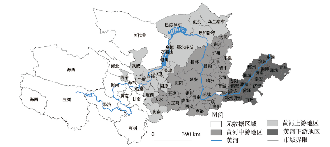
Based on the scientific connotation of green development, a comprehensive evaluation index system for green development in the Yellow River Basin was constructed, and various measurement methods such as entropy method, spatial autocorrelation analysis, and geographical detector model were used to study the spatio-temporal differentiation characteristics and the influencing factors of the green development in the eco-economic corridor of the Yellow River Basin. The results are obtained as follows: (1) The green development in the Yellow River Basin mainly originates from the external driving effects of large-scale expansion and the growth of total volume. Focusing only on pursuing the speed and scale of development but ignoring the connotative improvement of quality and efficiency will inevitably lead to the insufficiency of internal driving effects and unsustainability. (2) The number of areas with lower level of green development in the study area decreased continuously while that with a higher-level of green development rose slightly during the limited study period. However, the proportion of the numbers of areas with the lower level and medium-low level of green development remained above 65% for a long time, indicating that the level of green development needs further improvement. (3) From 2005 to 2017, the 61 prefecture-level cities in the Yellow River Basin generally showed relatively obvious spatial dependencies, and the green development level displayed a relatively obvious characteristic of spatial club convergence. The phenomenon of polarization in the study area was obvious. (4) The economic development level, science and technology level and government regulation are still the leading factors influencing the green development, and the explanatory power of interactions between factors for the green development far exceeds that of a single factor. This reflects the driving factors for green development in the Yellow River Basin are complex.
In order to investigate the pollution characteristics and human health risk of polycyclic aromatic hydrocarbons (PAHs) in heavy polluted weather in the typical urban and rural areas of the Fenwei Plain, PM2.5 samples were collected from Xi'an and Longxian in the winter of 2018-2019. The mass concentrations of 15 PAHs characterized by carcinogenicity, mutagenicity and teratogenicity in the samples were determined using gas chromatograph-mass spectrometer (GC-MS). The source of PAHs was analyzed by the diagnostic ratio and principal component method and the possible relation between PAHs mass concentrations and meteorological parameters was elaborated. In addition, human health risk caused by PAHs in PM2.5 was assessed through the equivalent carcinogenic concentration of benzo(a)pyrene (BaP) and incremental lifetime cancer risk (ILCR). The results showed that the average mass concentrations of PAHs in PM2.5 in heavy polluted weather in Xi'an and Longxian were 243.78 μg/m3 and 609.39 μg/m3, respectively, and 4-6 rings of PAHs had the highest proportion of the total. Moreover, PAHs concentrations had a significant negative correlation with atmospheric temperature, atmospheric pressure and wind speed, but irrelevant with relative humidity. Combustion source and automobile exhaust emissions were the main factors contributing to the high concentration of PAHs in Xi'an, while coal and biomass burning were the main factors contributing most to PAHs of Longxian. Health risk assessment results revealed that the carcinogenic risk caused by breathing during heavy polluted weather was higher in Longxian than that in Xi'an and the cancer risk for females was higher than that for males, and the cancer risk for adults was higher than that for children. In addition, the ILCR value of adults in both urban and rural areas exceeded the risk threshold recommended by EPA and had potential carcinogenic risks, while there was no obvious carcinogenic risk for children.
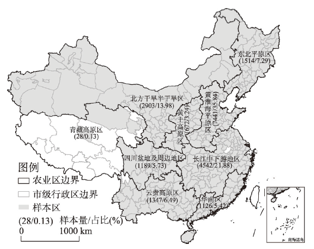
Developing large-scale farm management through farmland transfer is an important trend of agricultural land use change in China. The farmland rents regarding large parcels have profound impacts on the establishment of large farms and their sustainable development, however, there is still a lack of systematic monitoring and research on the rent of large consolidated land at the national level. Based on more than 20000 farmland parcels collected from the most influential land transfer information releasing platform (www.tuliu.com) in China, this paper reveals the overall picture and regional differences of farmland transfer price, and employs the quantile regression method to identify the impacts of parcel attributes on farmland rent differentiation and their heterogeneity. The results show that the average and median of scale-farmland rent are 11339.10 yuan per hectare and 9511.95 yuan per hectare, respectively. The farmland rents were further divided into four levels, namely, ≤ 7500 yuan per hectare, 7500~15000 yuan per hectare, 15000~22500 yuan per hectare and > 22500 yuan per hectare. According to this classification, the proportions of parcels in different rent ranges are 38.93%, 37.97%, 14.52% and 8.59%, respectively. Regarding regional difference, the farmland rents in the Yunnan-Guizhou Plateau and Huang-Huai-Hai Plain are relatively high, 32% and 23% higher than the national average respectively, while the rent in the arid and semiarid regions of northern China was relatively low, which was about half of the national average. Quantile regression results show that land quality, land suitability for large-scale farming operation, land location and land property attributes exert significant impacts on farmland rent. In particular, for lower-rent parcels, the marginal effects of irrigation availability, land flatness and road quality are stronger. However, expressway proximity has a stronger value-added effect on these higher-rent parcels. To reduce the farmland cost of agricultural production in China, the governments at all levels should continue to reduce transaction costs, set up market-based land rent mechanisms, strengthen the construction of farmland infrastructure, and establish a price monitoring system for large-scale land circulation.