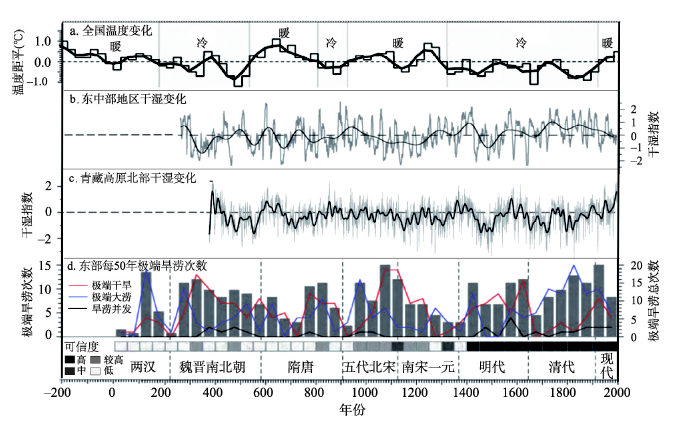
Understanding the changes of physical and human geographical environment during the past 2000 years in China is beneficial to establish the position, direction, focus areas, and initiatives of "Beautiful China" construction. In this paper, we integrated the results published in research papers, summarized the general characteristics of geographical environment changes in the history, and explored the implications of these changes on the construction of ecological civilization. The results implied that historical changes in China's land surface had been mainly manifested by the multi-scale quasi-periodic fluctuations and regional differentiation of climate, the fragmentation of the Loess Plateau, the expansion of desertified land in the northern regions, the gradual migration of delta coasts, the large scale shrinkage of lake systems especially in the Yellow River and the Yangtze River basins, and the decline in area of forests and the grasslands of northern China. Meanwhile, the economic and social changes were prominently reflected in the population growth and pattern changes, the migration of economic center to the southeast, the expansion of cultivated land to the periphery, and the transportation network evolution. From the above results, we could achieve the following enlightenments: in the future, the deserts in the northern region would still exist, and the lake systems in the middle and lower reaches of both the Yellow River and the Yangtze River were difficult to restore. The grain transportation from the south to the north disappeared in the history. But there was still much room for improvement in the coverage rate of forests, the transportation network could still achieve a higher level, and at the same time, we must mitigate the risk from climate change in the coastal cities.
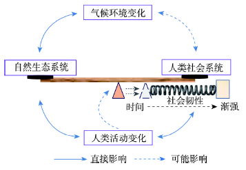
The trajectory, pattern, and mechanism of the human-land co-evolution process is a critical issue in the field of human geography. The pattern of human-environment interaction has varied significantly during different phases of human evolution, suggesting a series of changes in the driving force of human-land co-evolution. Although a variety of underlying mechanisms specific to the key periods of human history (e.g., Paleolithic, Neolithic, Bronze, and historical ages) have been intensively investigated, there are still significant gaps in the widely accepted model of the fundamental law that governs human-land co-evolution across human history. In this paper we propose the Fulcrum Cognitive Model (FCM), with the objective of disentangling the mechanism of human-land co-evolution. The FCM focuses on the equilibrium between the natural ecosystem and human social system, which can be disturbed by both climatic/environmental change and human activities, and restored by an adjustment of the human social system. Moreover, we propose a "quantitative-change equilibrium pattern" and "qualitative-change equilibrium pattern" on the basis of FCM, to further describe the mechanism of past human-land co-evolution in different contexts. In the former pattern, a new equilibrium between the natural ecosystem and human social system is rebuilt by the corresponding changes in population size, without a shift in the fulcrum position. In contrast, in the latter pattern, societies improve their social resilience to the deterioration of the living environment through social and/or technological changes. In this case, the fulcrum position of the original equilibrium shifts and the pattern of human-environment interaction is transformed. Social resilience is gradually strengthened during the evolutionary process and the dominant influencing factor moves from natural causes towards anthropogenic factors. To test its feasibility, we applied the model to the changing patterns of the human-land relationship in Shanxi, Shaanxi, and Henan provinces in central north China between the Yangshao period (~5000-3000 BCE) and Zhou Dynasty (1046-256 BCE), based on a comprehensive analysis of updated archaeological and paleoclimatic data. The results suggested that the mechanism controlling the human-land relationship during ~4000-2600 BCE and 2600-256 BCE could be explained by the "quantitative-change equilibrium pattern" and "qualitative-change equilibrium pattern", respectively. The mechanism of human-land co-evolution in the past is very complicated and the interaction of these two patterns may vary in terms of its spatiotemporal scale, which will require further study in the future.
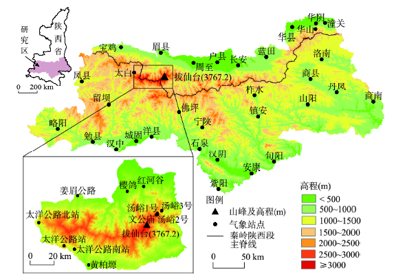
The National Basic Resources Investigation Program "Integrated Scientific Investigation of the North-South Transitional Zone" introduced the concept of north-south transitional zone (Qinling-Daba Mountains). Variation of north-south series in vegetation of the Qinling-Daba Mountains is of great significance to reveal the transition, diversity and complexity of the regional structure of China's north-south transitional zone. Based on the survey data of plant communities, in this study, the eastern Qinling-Daba Mountains is divided into four geography units: north flank of eastern Qinling Mountains (EQMN), south flank of eastern Qinling Mountains (EQMS), north flank of eastern Daba Mountains (EBMN), south flank of eastern Daba Mountains (EBMS). The regional climate divisions on levels of plant species, plant community structure and species richness are explored. The results show that: (1) On plant species level, there are mainly north plants in EQMN, evergreen species and fewer north plants in EQMS. Then to the eastern Daba Mountains, there are mainly south plants which like wetness and heat. (2) On plant community structure level, there are 4 formations (3 northern formations, 0 southern formation, 1 widespread formation) in EQMN, 6 formations (3 northern formations, 1 southern formation, 2 widespread formations) in EQMS, 4 formations (0 northern formation, 2 southern formations, 2 widespread formations) in EBMN, 3 formations (0 northern formation, 3 southern formations, 0 widespread formation) in EBMS. In terms of the numbers and properties of formation, there is a mixture of northern and southern formations only in EQMS. On species richness level, the diversity of family, genus and species decreases with the increase of latitude, but the mixture of north and south plants occurred in the south flank of eastern Qinling Mountains. This paper studies the variation of series in vegetation, which increases the scientificity of determining north-south dividing line, and shows that the south flank of eastern Qinling Mountains is more suitable as the warm temperate-subtropical zones dividing line.
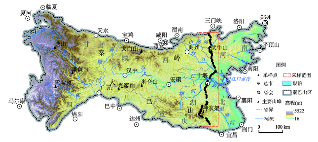
The Qinling Mountains, located at the junction of warm temperate and subtropical zones, serves as the boundary between North and South China. Exploring the sensitivity of vegetation response to hydrothermal dynamics can be conducive to understanding the pattern and dynamics of main vegetation types and the mechanism of their response to changes in temperature and moisture. Importance should be attached to the laws of vegetation change in different climate zones. To reveal the sensitivity and areal differentiation of vegetation responses to hydrothermal dynamics, the spatial and temporal variation characteristics of NDVI and SPEI on the southern and northern slopes of the Qinling Mountains from 2000 to 2018 are explored using the meteorological data from 32 meteorological stations and the MODIS NDVI datasets. The results show that: (1) The overall vegetation coverage of the Qinling Mountains improved significantly from 2000 to 2018. The NDVI rise rate and area ratio on the southern slope were higher than those on the northern slope, and the vegetation on the southern slope exhibited better improvement than that on the northern slope. The Qinling Mountains showed an insignificant humidification trend. The humidification rate and humidification area of the northern slope were greater than those on the southern slope. (2) Vegetation on the northern slope of the Qinling Mountains was more sensitive to hydrothermal dynamics than that on the southern slope. Vegetation was most sensitive to hydrothermal dynamics from March to June on the northern slope, and from March to May (spring) on the southern slope. The vegetation on the northern and southern slopes was mainly affected by hydrothermal dynamics on a scale of 3-7 months, and it responds weakly to hydrothermal dynamics on a scale of 11-12 months. (3) 90.34% of NDVI and SPEI were positively correlated in the Qinling Mountains. Spring humidification in most parts of the study area could promote the growth of vegetation all the year round. The sensitivity of vegetation responses to hydrothermal dynamics with increasing altitude increased first and then decreased. The altitude of 800 to 1200 m was the most sensitive altitude for vegetation response to hydrothermal dynamics. The sensitivity of vegetation response at the elevation of 1200-3000 m decreased with the increasing altitude. The grass was the most sensitive vegetation type to hydrothermal dynamics on the northern and southern slopes of the Qinling Mountains, but most of other vegetation types on the northern slope were more sensitive to hydrothermal dynamics than those on the southern slope.
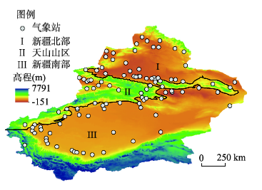
Xinjiang, a unique natural unit, is sensitive to the global warming. Studies on the spatial-temporal variation and impacts of drought and wetness in Xinjiang have a significant effect on the adaptability of future climate change. Based on observations of monthly mean temperature, monthly precipitation, and calculated standardized precipitation evapotranspiration index (SPEI), this paper analyzes the drying trend and impacts of climate change on the water resources and vegetation dynamics over Xinjiang, China. The results can be shown as follows: (1) The climate experienced a significant shift from warm-wet to warm-dry over Xinjiang in 1997 based on the SPEI data, after which the frequency, trend, dry months and percentage of stations of drought increased sharply. (2) The increased meteorological drought severity had a direct effect on the normalized difference vegetation index (NDVI) and river discharge. The NDVI exhibited a significant decrease during the period 1998-2015 compared with 1982-1997, which was found to be caused by increased soil moisture loss. (3) The hydrological drought was very complicated and not entirely comparable to the SPEI droughts. Hydrological records indicate that runoff in most rivers in the Tianshan Mountains has increased, while it remained stable or even decreased slightly in the Kunlun Mountains over the past 20 years. The runoff in Xinjiang is strongly influenced by glacial melt, and it is getting worse due to global warming. The climatic shift and intensified climate extremes over Xinjiang have resulted in SPEI-drought severity. These changes also have possibly intensified the instability of water cycle system and ecosystem. The results provide valuable decision-making reference for the regional drought disaster prevention, reduction and emergency management over Xinjiang, China.
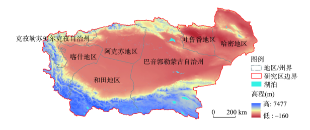
Based on the three dimensions of "hazard-formative factors, hazard-formative environments, hazard-affected bodies", we assessed the risk of sandstorm diffusion in the southern Xinjiang using the Spatial Principal Component Analysis (SPCA) method. A multi-level ecological network was built and components of key landscape patterns were optimized by the Minimum Cumulative Resistance (MCR) model. (1) The risk of hazard was high in this region by single dimension factor analysis. Under the action of wind, eight sandstorm source areas and Tarim Basin were prone to sandstorm diffusion because of the existence of abundant sand materials. The hazard-formative environment was relatively fragile. Hejing and Aheqi counties had relatively good ecological background. In the Tarim Basin and its southern counties, the sandstorm tends to spread, especially in Hotan Prefecture, and counties of Qiemo and Ruoqiang. Oasis population and agricultural production were highly concentrated and vulnerable to environmental factors. (2) Some 46.53% of the area had high risk of sand diffusion due to abundant sand sources and poor site conditions. The most important factors affecting the wind sand diffusion were vegetation coverage and soil types of the underlying surface. The main causes of regional sand source diffusion were the intensity of wind field. (3) Based on the MCR model, 20 ecological corridors were constructed to connect ecological source areas, including five river types, nine road types and six green belt types of corridors. Among them, corridors 1 and 4 connected via Taklimakan Desert, and the rest of the corridors presented a circular distribution pattern at the outer edge of Tarim Basin. At the same time, 30 ecological nodes were identified, including seven class-A ecological nodes and 23 class-B ecological nodes, which were mainly distributed in Hotan and Bayingolin prefectures. The risk of sandstorm diffusion can be reduced by constructing shelterbelts and improving vegetation coverage. Results provide technical support for the prevention and control of sandstorm diffusion and the optimization of landscape patterns in the arid and semi-arid areas of northern China.
Freeze-thaw erosion is the main erosion in the Qinghai-Tibet Plateau. In this study, both the failure process and the transport process of the soil on a slope are analyzed under a similar climatic condition in eastern Tibet. It reveals that the sensitivity factors should be divided into the latent factor and the dominant factor. The latent factors change gradually over time, which include the geological structures, the lithology, and the slope direction. The dominant factors with catastrophe include the climate, the sloping topography, and the vegetation cover. The driving forces of freeze-thaw erosion are the gravity force and hydrodynamic force, while the erosion resistance is controlled by the dual structure of soil and the anchoring force of vegetable roots. On a temporal scale, the freeze-thaw erosion is a cyclic evolution process. It begins with the weathering of bedrock and soil formation, goes through the freezing-thawing and the tensile failure process, and ends with the re-exposure of bedrock after the soil is transported. Generally, this cycle should last a long term, but it could only last several years or decades of the period due to the structure of the soil. Based on the failure mechanism of the limit equilibrium state of the soil, freeze-thaw erosion can be divided into trailed progressive disintegration and multi-level disintegration type, both of which have the characteristics of 'multi-pathogenesis and same symptoms'. The characteristic parameter of freeze-thaw erosion intensity is introduced to describe how those influence factors affect the mechanism of freeze-thaw erosion. The formula is established by the relationship between the intensity value and the factors including both latent factors and dominant factors. It can be used to forecast calculate the amount of soil erosion when there is a standard-value in the study. Although there are still a few discretization errors in the formula building because of the randomness of sensitivity factors, the fitting results can still explain more than 90% of the evolution trend. Moreover, a new model of freeze-thaw erosion intensity based on soil erosion observation is proposed. Therefore, different from previous research, in this paper, the new model of erosion intensity can effectively reduce the errors caused by regional suitability and provide a theoretical basis for formulating countermeasures under different conditions.
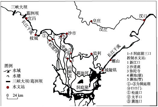
Water and sediment transport processes have been changed by the operation of larger scale reservoirs, which can result in the adjustments of river topography and water levels. The polynomial fitting method was applied to analyze the variation characteristics of the water levels under different characteristic water discharges in the Jingjiang reach of the Yangtze River during 1991-2016. The segregation variable method was used to estimate the contributions of the varied riverbed evaluation, the downstream controlled water level and the comprehensive roughness on the altered water level at the same flow. The results obtained are as follows: (1)The low water level in the Jingjiang reach of the Yangtze River during 1991-2016 presented a significant downward trend, and this trend intensified since 2009; riverbed scouring was the dominant factor for the reduced low water level, while the increased roughness alleviated this reduction. (2) During 1991-2016, the high water level decreased firstly and then increased. The variation characteristic of "high flood discharge with high water level" before 2003 transformed into "average flood discharge with high water level" since 2009. The increased comprehensive roughness was the main reason for the increased high water level, while the river scouring alleviated this increase. For navigation conditions and flood control, the intensifying riverbed scouring of the sandy reaches downstream dams enhanced the effects of the downstream water level on the upstream water level. (3) This led to the insufficient water depth in the reaches below dams, which should arouse great attention. The variation characteristics of high water level increased the flood pressure in the middle reaches of the Yangtze River.
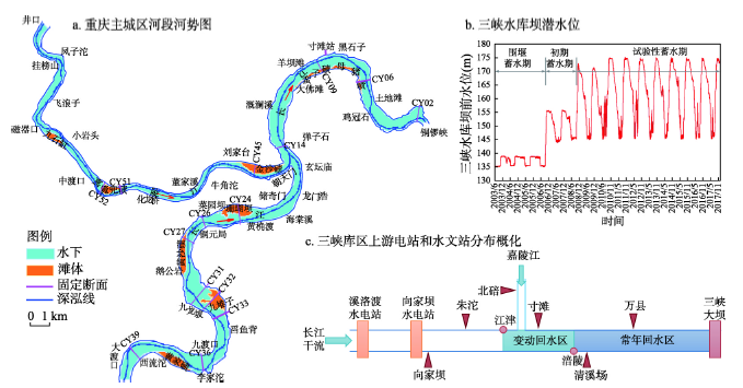
Chongqing reach is located in the fluctuating backwater zone of the Three Gorges Reservoir (TGR). Sediment deposition and erosion of Chongqing reach is related to flood control, shipping and wharf operation. It has become one of the key problems the TGR faces. In this paper, based on the prototype observation data, the sediment scouring and silting law of Chongqing reach before and after the 175 m experimental impoundment of the TGR was investigated for the first time. In addition, combined with the analysis of river bed composition and the one-dimensional mathematical model, the scouring conditions of suspended sediment in Chongqing reach were calculated and analyzed. Furthermore, the basic conditions of sediment transport in the study reach were applied to the practice of sediment reduction of the TGR. The following conclusions can be drawn as follows: (1) From 2008 to 2012, when the water storage level of TGR reached 175 m, the erosion intensity of the river bed in Chongqing reach started to decline, and the main souring period of suspended load was postponed from the water-impoundment stage to the pre-flood stage. After 2013, Xiluodu and Xiangjiaba hydropower stations in the lower reaches of Jinsha River was completed and put into operation. The sediment of Jinsha River was intercepted and the sediment entering the Three Gorges was greatly reduced, which led to another increase of the river bed scouring intensity of Chongqing reach. (2) When the inflow in front of the Three Gorges Dam (TGD) is greater than 4000 m 3/s and the water level is lower than 167 m, the suspended load on the river bed in Chongqing reach begins to scour. When the inflow exceeds 5000 m 3/s, the water level in front of the TGD drops to 163 m, and the scouring intensity of suspended load increases obviously. Increasing the drawdown rate of water level from 163 m before the TGD to 30 cm per day can avoid the cumulative sedimentation in the Chongqing reach.
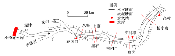
One of the main tasks for the river regulation in the Lower Yellow River (LYR) is to improve sediment transport capacity of the braided reach, which is influenced by incoming flow and sediment regime as well as riverbed boundary condition. Variations in the reach-scale geomorphic coefficient and incoming flow-sediment regime (incoming sediment coefficient and fluvial erosion intensity) were investigated, using the hydrological data and cross-sectional profiles surveyed in the braided reach between Huayuankou and Gaocun over the period from 1971 to 2016. Empirical relationships were then established to quantitatively demonstrate the integrated effects of flow-sediment regime and the post-flood channel geometry in the previous year on the values of sediment delivery ratio (SDR) during flood seasons and flood events respectively in the study reach. Results indicate that: (1) the values of SDR of flood seasons and flood events increased with a smaller incoming sediment coefficient or a larger fluvial erosion intensity, and the incoming sediment coefficient was equal to 0.012 kg·s/m 6 when the value of flood-season SDR approached 1. The correlation coefficient is 0.76 for the relationship between flood-event SDR, incoming sediment coefficient, and the ratio of the water volume at the inlet section to the one at the outlet section in the study reach. (2) The SDR of the braided reach decreased with wider and shallower channel geometry, and it was less than 1 when the geomorphic coefficient was greater than 15 /m 0.5. (3) The determination coefficient is 0.82 for the empirical function established among flood-season SDR, incoming sediment coefficient and geomorphic coefficient, and the weight of the channel geometry is greater than the incoming sediment coefficient in the function of flood-event SDR. The established functions can reflect the sediment-transport characteristics of the braided reach, which is helpful to quantify the influence of channel geometry and flow-sediment regime on sediment transport capacity.
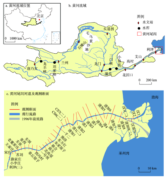
The implementation of the Water-Sediment Regulation Scheme (WSRS) since 2002 has changed the water and sediment entering the Yellow River Estuary, which may lead to adjustment of the estuarine channel. Based on the elevation data of 41 transects from 2002 to 2017 in the estuarine channel downstream from Lijin, we established a digital elevation model (DEM) based on curved orthogonal grids to investigate the spatiotemporal characteristics of channel erosion and deposition, and further analyzed its controlling factors combining the morphological changes of river mouth and water-sediment data. The results show that the Yellow River estuarine channel has undergone significant erosion with a total sediment volume of 62.4×10 6 m 3 since 2002. The channel evolution process can be divided into three stages according to the rates of erosion or deposition, namely: rapid erosion (2002-2005), slow erosion (2006-2014), and slow deposition (2015-2017). Approximately 80% of the total eroded sediment was depleted in the first stage. The erosion flux has shown a significant decreasing trend after 2006, and the overall characteristic of the channel transferred from erosion into deposition afterwards. On a seasonal scale, the estuarine channel was eroded in the flood seasons and deposited in the non-flood seasons; from the spatial perspective, the erosion intensity decreased in the downstream direction. The operation of the WSRS changed the distribution of water and sediment entering into the sea during a year, most of which was delivered in a short time (no more than 20 days), thus caused the continuous erosion of channel as well as the morphological adjustments of the estuarine channel. As a result of the intensive erosion in the first stage, the estuarine channel riverbed has lowered so much, and accompanied by the impact of the extension of river mouth, the erosion efficiency decreased continuously. Besides, the channel reach near the mouth has undergone significant siltation after the first stage causing the decline of riverbed longitudinal slope, which increased the instability of the estuarine channel.
Practices in developed countries reveal that low impact development based on rainfall flooding control measures can effectively alleviate rainfall flooding. Focusing on the relevance of new and old towns in the development of sponge cities in China, we try to put forward a stormwater management path of "present situation appraisal - decomposition of low impact development indicators - simulation and verification of construction result". A case study is unfolded on Fenghuang County, Hunan Province. On the basis of urban waterlogging model, the rainfall flooding risk evaluation and renewal feasibility evaluation is conducted on the new and old towns; based on the evaluation of the present situation, a low impact development control indicator decomposition system is established accordingly to implement low impact development conceptually and technically from macro control strategy to detailed planning, and the validity of this path is verified through simulation of the water accumulating volume of the stagnant point. The results indicate that the old towns of Fenghuang County have a higher rainfall flooding risk and an evidently lower current annual runoff volume control rate than the new towns, however, the old towns have a much lower transformation feasibility than the new towns due to large historical and cultural preservation areas and a lower terrain. From the perspective of the integrity of new and old towns, more runoff discharge and peak runoff can be reduced by establishing a three-level (Proper-Block-Plot) indicator decomposition system so as to lighten the pressure of flood disaster in the lower old towns. However, under the circumstance of heavy rainstorm, it is still very difficult to solve the problem of waterlogging only by low impact development facilities, and grey infrastructures based on water accumulating volume calculation are also needed in order to efficiently control water logging caused by short intense rainfall.
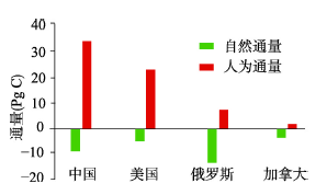
As a major climate forcing factor, CO2 is closely related to human activities, but many studies have overlooked the carbon absorption of terrestrial ecosystem to anthropogenic carbon emissions. China, the United States, Russia and Canada are the four countries with the largest area in the world at different socio-economic development stages. Quantifying the global radiative forcing contribution of CO2 emissions is important for assessing the climate effects of human and natural factors. Based on CO2 assimilation data, this study used a "carbon-climate" parameterization scheme to analyze the anthropogenic carbon emissions and its climatic effects while considering the climate effects of carbon sinks of terrestrial ecosystem. Then we obtained the net global radiative forcing contributions of the four countries. The results showed that the anthropogenic emissions of CO2 in all the four countries showed a significant increase (0.125 Pg C a -1). Meanwhile the carbon uptake of terrestrial ecosystems increased at a growth rate of 0.003 Pg C a -1. During the study period, the total anthropogenic carbon emissions of China and the United States accounted for 87.19% of the four countries while Russian terrestrial ecosystems had the strongest carbon absorption capacity, 14.69 Pg C. Correspondingly, as of 2016, the cooling effect of terrestrial ecosystems is -0.013 W m -2, which can offset 45.06% of the whole warming effects of anthropogenic carbon emissions, indicating that if the terrestrial ecosystems are not considered, the warming effect of anthropogenic carbon emissions will be significantly overestimated. Overall, the total anthropogenic carbon emissions of the four countries contributed 0.32 and 0.42 W m -2 of global radiative forcing, respectively, relative to the CO2 concentration levels before 2000 (initial year of this study) and before the Industrial Revolution. This study further explored the linear relationship between air temperature and radiative forcing. Compared with a single climate effect of anthropogenic or natural carbon emissions, the combined radiation forcing and the temperature change in the corresponding period had the highest consistency (30.3%).
Glaciers provide essential resources and services for human well-being and socio-economic development in arid regions, and estimation on service value of glaciers and its spatiotemporal characteristics are vital for socio-economic sustainable development and environmental protection. Based on the first and second glacier inventories, this research firstly constructed an assessment system of glacier service value. The glacier service value and its variation with time and space were then estimated by combining the unit area service price method, equivalent factor method and glacier service change index. The total glacier service value in the Qilian Mountains for 2016 was 24354 million yuan. The main parts were climate regulation and runoff regulation, which occupied 60.58% and 33.14% of the total value, respectively. The minor parts were freshwater supply and hydropower, which contributed 3.47% and 1.75% to the total, respectively. The service value of the rest parts was about 259 million yuan. For glacier service value of the watersheds in the Qilian Mountains, Shule River ranked first with 7771 million yuan, or 31.91%, followed by Haerteng River with 4321 million yuan (17.74%) and Beida River with 3281 million yuan (13.47%). From an administrative perspective, the glacier service value of the Qilian Mountains in Qinghai province was 1138 million yuan higher than that of Gansu province. For Qinghai, Haixi Mongolian Tibetan Autonomous Prefecture had the highest glacier service value with 11124 million yuan, accounting for 45.68%. For Gansu, the correspondent value was Jiuquan with 7758 million yuan, or 31.86%. During the period of 1956-2010, the loss of glacier service value in the Qilian Mountains increased faster from west to east, reaching 435 million yuan. This suggested that the change of glacier service value in the study region showed an obvious longitudinal and zonal differentiation.

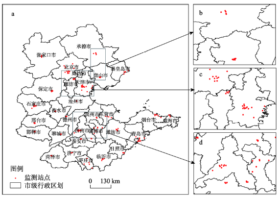
The individual exposure level of fine particulate matter (PM2.5) is a key issue in the study of health effects. However, the lack of historical data and the small coverage of ground monitoring stations have hindered the development of related research. Based on the aerosol optical depth (AOD) provided by NASA remote sensing data, multi-source data such as ground monitoring and meteorological data were integrated for modeling to estimate near-ground PM2.5 concentration. The results have wide spatial coverage, strong time continuity and low method cost. Based on the Beijing-Tianjin-Hebei-Shandong region in 2018, this paper introduces 50 features such as meteorological elements, NDVI, time nodes and spatial markers to analyze the relationship between AOD and PM2.5. In view of the information loss caused by the single traditional interpolation method, the spatiotemporal multi-view interpolation method is used to improve the accuracy and coverage of interpolation. Considering the complex relationship caused by hysteresis of features, and the correlation and partial correlation between features, this paper uses a distributed perception deep neural network model (DP-DNN) to separately capture higher-order features between multiple-source features. The results show that: (1) The relative error of the spatiotemporal multi-view interpolation method is 27.5%, and the average proportion of missing data decreases from 52.1% to 4.84%. (2) In terms of time prediction, mean absolute error, relative error, mean square error and root mean square error of DP-DNN are 7.7 μg/m 3, 46.8%, 766.2 μg 2/m 6 and 26.9 μg/m 3, respectively. In terms of space prediction, they are 16.6 μg/m 3, 41.8%, 691.5 μg 2/m 6 and 26.6 μg/m 3, respectively. In aspects of accuracy, robustness, generalization ability and time consuming, the results are superior to linear statistical models and common deep learning architecture.
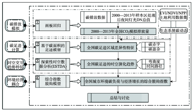
The global environment issue resulting from carbon emissions has aroused worldwide concern for governments, the public and scientific communities. A precise measurement of the time-resolved and spatial distribution characteristics of carbon dioxide (CO2) and carbon footprint as well as its long-period evolution mechanism, can help clarify the relationship between environmental carbon load and economic growth, and are critical references to the formulation of scientific carbon emission reduction targets with reasonable and differential emission reduction policies. In this study, the mainland of China is taken as the research object. According to the quantitative correlations between DMSP-OLS nighttime light image data and carbon emission statistics, the carbon emission panel data model was simulated for China's carbon emissions in the period 2000-2013, and then the spatiotemporal evolving trend and spatial distribution characteristics of carbon emissions in the 14-year research period were discussed using Theil-Sen Median trend analysis and Mann-Kendall test method. Based on the framework of exploratory spatial-temporal data analysis (ESTDA), the spatial pattern and spatiotemporal dynamic evolution of carbon footprint from 2001 to 2013 were analyzed from the perspective of spatiotemporal interaction. In the three periods, the decoupling effect between environmental carbon load and economic growth of 336 prefecture-level cities were analyzed using the improved Tapio decoupling model. The results show that the overall carbon emissions in China had been on the rise from 2000 to 2013, in which the stable-slow rise type was dominant. China's carbon footprint and carbon deficit increased year by year, and the central and western regions became the focus of the growth of carbon footprint and carbon deficit from 2001 to 2013. At different administrative city scales, the spatial distribution pattern of carbon footprint and carbon deficit show obvious administrative orientated and spatial zonal differentiation characteristics. The annual average of global Moran's I index of each level unit is 0.491, which indicates that there is a significant spatial auto-correlation feature in the carbon footprint of China's prefecture-level units. The relative length of the LISA time path is greater in the north than in the south, and it tends to increase from the coastal areas to the central and western regions. The curvature of LISA time path decreases from coastal areas to inland areas on the whole. The curvature of northeast and central regions is higher, while that of eastern and western regions is lower. There is a different trend of the decoupling effect of environmental carbon load in China. Meanwhile the expansion-connection and expansion of negative decoupling regions continuously increased and spatially agglomerated, presenting an "E"-shaped distribution pattern from the north to the south. The national average decoupling elastic value is gradually increasing, while the coefficient of variation continues to decline, and the decoupling type has a significant evolution trend. Therefore, the unbalanced trend of economic growth and carbon emissions in China will continue for a certain period.
Forest ecosystems play important roles in provisioning and regulating services. In China, forest ecosystems have been facing problems such as poor quality, simple structures, and weak ecological functions. Scientific, reasonable, and applicable forest management strategies are concerned with optimizing the structure of forests, achieving sustainable development, and promoting ecological functions while meeting production requirements. Therefore, a coupling path of the ecosystem progress model (PnET-II) and landscape model (LANDIS-II) were used to simulate dynamic changes in the area and aboveground biomass (AGB) of the plantations over the next 100 years, considering from the initial year (2009). The variables of the designed factorial experiment were cut-block size, cutting area ratio, as the initial year cutting age and cutting frequencies. It was found that the cutting age and cut-block size had limited impacts on the forest area, although they affected the levels of AGB. Both the cutting area ratio and cutting frequency, however, had significant impacts on forest area and AGB. Moreover, the cutting area ratio was a crucial variable with the greatest influence on forests among the four variables. The management strategy of a harvest scenario with a 20% cutting area ratio, 5 ha cut-block size and 10-year cutting frequency on 21-year-old Chinese fir, 26-year-old pine and 41-year-old broad-leaved forests provided the optimal results among all the tested scenarios. This ensured that the AGB of the forest remained relatively stable during the simulation. Therefore, it is an effective way to maintain the ecological functions of artificial forests while producing wood.
Zhang Qiyun was one of the founders of modern Chinese geography. He has made outstanding contributions to geography education, political geography, historical geography, and regional geography in modern China. In terms of regional geography, he introduced Western works to China initially, and translated the phrase "regional geography" as "local gazetteers". In addition, he expounded the concepts, contents, and research methods of Western regional geography, and tried to construct the theoretical system of Chinese regional geography. His regional geography works were also widely disseminated. Zhang Qiyun's research focused on regional division and geographical investigations, which placed on emphasis on the use of maps as well as the interpretation of human-land relationships. His thoughts on regional geography are mainly derived from the theories and methods of the human-land relationship proposed by Paul Vidal de La Blache, a modern French geographer. Distilling the thoughts and academic achievements of Zhang Qiyun is of great help for understanding the development of regional geography in modern China.