Agricultural geography is the interdisciplinary subject of agricultural science and geographical science, and agricultural geographical engineering is the further deepening and systematic application of the interdisciplinary research of geography and engineering in the field of modern agriculture and rural revitalization, and it is an important material basis to ensure the agricultural high-quality development. With the innovative development of modern agricultural science and technology and human-earth system science, the scientific and technological needs of regional agricultural infrastructure are increasingly strong, and agricultural geographical engineering experiments have become an important task of agricultural engineering technology research and farmland system management. This article expounds the scientific connotation, experimental principles and technical methods of agricultural geographical engineering, and takes the loess hilly and gully region as an example to carry out the experimental research on geographical engineering and discussed the countermeasures for high-quality agricultural development. Results show that: (1) Agricultural geographical engineering experiments mainly include soil and water allocation, soil layer composition, field experiment, ecological protection, geospatial analysis and monitoring for specific regional geographical environment and agricultural development issues, aiming to explore coupling law of resource elements for regional high-standard farmland construction and healthy agricultural ecosystem construction, and establish a sustainable land use system and multifunctional agricultural management model. (2) Agro-ecosystem experiments mainly includes trench slope protection methods, healthy farmland system structure, crop-soil matching relationship, economic analysis of farmland input and output, which aimed to reveals the coupling mechanism and optimal control approach of "crop-soil relationship" by carrying out interactive experiments and field trials for land improvement and crop optimization. (3) Optimization and regulation of crop-soil relationship is the main content of engineering experiment design, which includes six stages: climate-crop optimization, soil-body structure improvement, terrain-crop optimization, soil quality improvement, soil-crop optimization and benefit-crop optimization. (4) The core tasks of the application of agricultural geoengineering technology are to deepen the comprehensive research, reveal the micro-coupling mechanism and establish the engineering test paradigm, and its application path is mainly reflected in three dimensions of time, space, and logic. The geographical engineering experiment of modern agriculture and its application in the new era are conducive to enriching the frontier theories and methodology of agricultural geography, and are of great significance to the advancement of geographical engineering research and the decision-making of agricultural and rural high-quality development.

Although many theoretical schools have been developed and thrived in the field of "geopolitics" in Western academia over the past 120 years, the influence of geopolitical research has been declining partly due to the lack of concern for realistic issues, which is embedded in its traditional research agenda. In China, geopolitical studies have mostly followed the Western approach until 2010 when a new "geo-setting" research agenda was launched. This geo-setting research agenda incorporates geographic knowledge and politics into the process of geopolitical analysis, which has demonstrated both theoretical and practical significance because it not only brings reform and innovation to geopolitical studies but also contributes to the promotion of the Belt and Road Initiative and the construction of a community with a shared future for mankind. This paper proposes a research approach and an analytical framework for nationa-state based and integrated interdisciplinary geo-setting studies, according to previous academic findings on geo-setting, including conceptualization, leading elements, structure, and simulation. This framework is illustrated by a case study of Japanese geo-setting during the period of Tokugawa Bakufu. From an integrated interdisciplinary perspective, this paper unveils how the Japanese geo-setting had evolved under the combined effects of both domestic and international factors at multiple scales. It also sheds light on Japan's domestic and external policy formulation and changes during the period of Tokugawa Bakufu. Finally, three suggestions are put forward to strengthen the current nation-state based geo-setting research: (1) to continue to apply the interdisciplinary approach; (2) to highlight an integrated approach featured by multi-factor, multi-scale and long-term analysis; and (3) to pay consistent attention to long-term dynamic simulation.
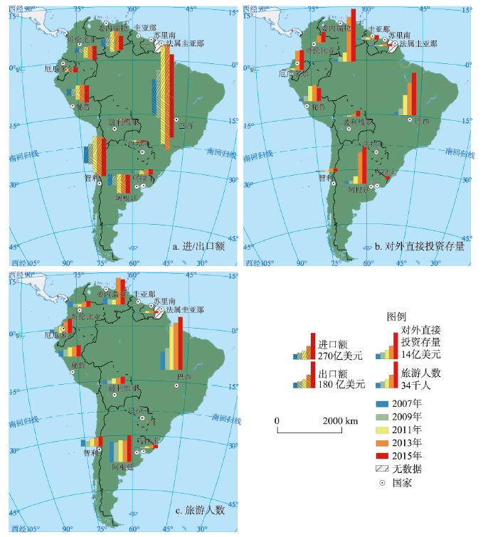
As an expansion area of international cooperation under the Belt and Road Initiative, South America is of great importance for China to enhance geo-economic status and expand geo-economic space. Based on trade, investment, tourism, transportation and politics, this paper establishes a multi-dimensional index system of geo-economic linkages intensity and analyzes the important characteristics of the geo-economic linkages intensity between China and countries in South America by using the gray correlation TOPSIS method and geographically weighted regression model. The results show that: (1) The geo-economic flows between China and South American countries show an overall increasing trend during 2006-2015. (2) China and South American countries have an unbalanced development in geo-economic linkages elements. The geo-economic linkage of transportation is higher than that of politics, tourism, investment and trade. (3) The geo-economic linkages intensity between China and South American countries are at a low level and varies significantly among countries. (4) The geo-economic linkages intensity between China and South American countries is slowly increasing, and the changes in spatial pattern are small year by year. (5) Gross domestic product, population size and cooperative goldenstein factor are the dominant factors influencing the geo-economic linkages intensity between China and countries in South America. Market is the most important driving force for geo-economic linkages intensity between China and countries in South America. Resource endowment has little effect on the geo-economic linkages intensity, while geopolitics has a significant effect on the geo-economic linkages intensity.
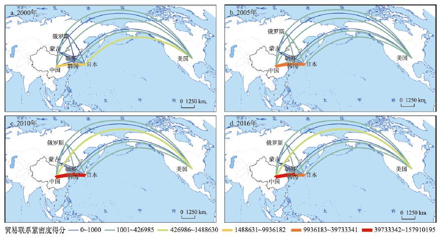
With the advancement of globalization and market economy, geo-economic relation has increasingly attracted scholars' attentions. Trade data, including import and export flows, has dominated the geo-economy research owing to its availability and representativeness. However, this might incline geo-economy research toward trade studies and disregard the importance of other international economic components, such as investment. Combining investment and trade data in doing geo-economic analysis could provide us with a more comprehensive understanding of economic relations between countries. Taking China, the US and Northeast Asian countries as an example, this paper explores the patterns of geo-economic relations between these countries, inspects the driving forces and formation mechanism of the patterns, and also makes comparison between China and the US. As a typical region with unbalanced politics and economy and greatly influenced by both China and the US, Northeast Asia can be a salient sample for geo-economic research. A geo-economic streaming potential model is proposed to evaluate comprehensive geo-economic relations which take into account both trade and investment. The conclusions are as follows. First, from 2000 to 2016, the geo-economic relations between China and Northeast Asian countries were strengthened, during which trade flow constantly occupied the dominating position. However, since 2012, the proportion of investment in geo-economy has increased rapidly. Second, the geo-economic flows between China and the US were the strongest with the fastest growth. The geo-economic flows between China and Japan, South Korea were increasing, while those between China and Russia, Mongolia and North Korea had limited influence. Third, both China and the US had expanding geo-economic flows with Northeast Asian countries and similar distribution pattern. Two major differences are also noted. One is that driving forces are different with China's geo-economic relations driven by trade flows and those of the US driven by investment. The other difference is that China's connections with Russia, Mongolia and North Korea have been strengthened while the US has been trying to maintain strong geo-economic relations with Japan and South Korea.
Although more and more people realize the important role of the urbanization process on the economic, political and environmental systems along the Belt and Road, the study on urban expansion and form changes is still limited. Based on the latest 300 m resolution global land cover dataset from 1992 to 2015 released by the ESA Climate Change Initiative project, DMSP/OLS night lighting data from 1992 to 2012, and LandScan population data from 2000 to 2015, in this paper we first analyzed the spatial pattern of urban land growth and dynamics in the ten major sub-regions along the Belt and Road from 1992 to 2015. Then, by analyzing the spatial and temporal changes of urban land density in concentric rings in 1992, 2003 and 2015, the expansion and form changes of 80 cities along the Belt and Road were quantified. Finally, the long-term relationships between urban land area, weighted lighting area and urban population were quantified by using three statistical models, including linear, power-law and exponential function models. The results show that the urban land area along the Belt and Road increased from 0.24% in 1992 to 0.56% in 2015, and developing countries in Africa and Asia are major contributors. The density of urban land in the concentric rings is decreasing from the city center to the urban fringe, and the spatial distribution between cities is completely different. Comparisons among cities in China, Europe, Africa, West Asia, Southeast Asia, and India with populations of more than one million, show that, in addition to the decentralization of China's urban form, the overall urban form of other sub-regions became compact. Further analysis results show that the urban economic vitality and urban population distribution trends will affect the urban spatial expansion and form changes at different levels.
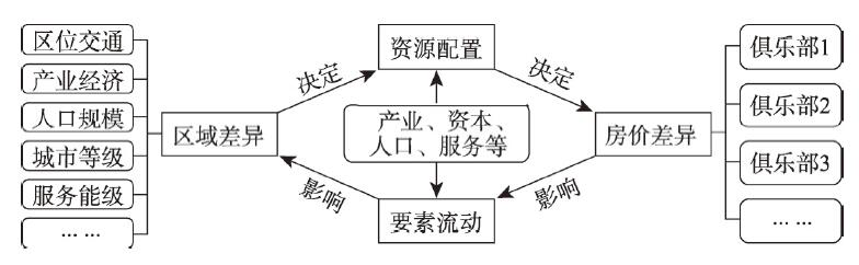
Since the market-oriented reform of the housing system, China's urban housing prices have risen rapidly, and regional differentiation intensifies. Although the Chinese government has repeatedly emphasized that "housing is for living, not for speculation" the trend of rising prices in cities has not been suppressed, and the spatial differentiation of regional urban housing prices has become highlighted. Spatial differentiation of housing prices is a comprehensive reflection of the urban development gap, or a materialized expression of the differences in urban resource allocation abilities. Taking the integrated region of the Yangtze River Delta as an example, and based on the average urban housing price data of prefecture-level cities, districts, and counties between 2008 and 2018 provided by China Housing Prices, we found that the housing prices experienced three stages, namely, "fast growth", "relatively stable", and "faster growth". When the prices grew, the gap of prices between cities, especially between districts and counties, also grew, that is, integrated development did not bring about the convergence of regional housing prices. The housing prices in core and central cities, like Shanghai, Nanjing, and Hangzhou, grew more quickly, and the gaps between Zhejiang/Southern Jiangsu and Anhui/Northern Jiangsu became more obvious. Similarly, there was a huge gap in the housing prices of different districts and counties in a city. Out of consideration for reducing data error and raising analytical accuracy, and based on clarifying the pattern of spatial differentiation of urban housing prices, this paper mainly takes district and county as analysis units, and discusses the growth of housing prices in different types of districts and counties. According to the characteristics of housing price growth, city level, and location, this paper divides the 327 districts and counties of the Yangtze River Delta into six types: urban areas of core cities, urban areas of central cities, urban areas of developed cities, urban areas of other cities, counties and cities in the core circle, and counties and cities in the peripheral regions. It also discovers that, in the process of regional integration, resources flow more quickly, and high-end elements gather towards a small number of superstar cities. This means that the integrated region presents a faster price growth, a larger gap between core-edge housing prices, and the stronger convergence of similar city clubs. On this basis, we identify the mutual feedback effect of the urban economic and social differences in the integrated region, the flow of resource elements like industry and population, and the spatial differentiation of urban housing prices. The increased difference in regional housing prices will result in the forced upgrade of industries in cities with high housing prices, the loss of low-end manufacturing posts, and the concentration of social wealth to "superstar cities". Finally, in combination with the requirement for high-quality integrated development of the Yangtze River Delta, and the judgment on the rationality of regional urban housing price differentiation, this paper proposes pertinent suggestions to the adjustment and control of urban housing prices.
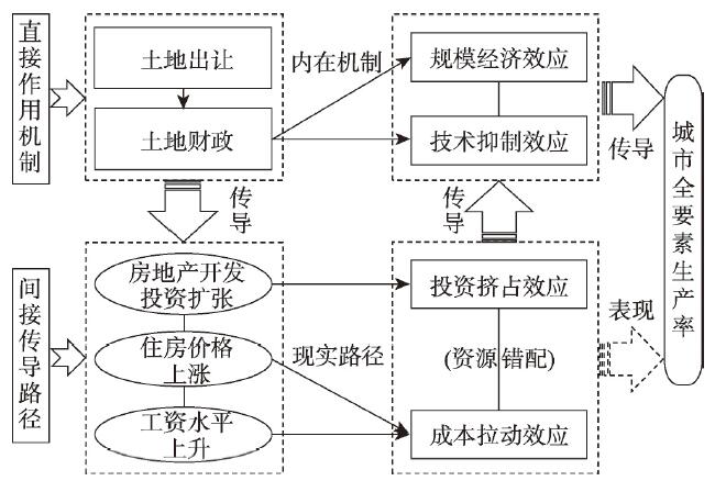
Land finance has been favored by local governments along with the rapid expansion of urbanization and industrialization, but it draws the attention of the central government recently and then tends to be alleviated. The influencing process of land finance on economic efficiency is systematic and complex. Considering the structural characteristics of economic efficiency growth, this paper constructs the multi-level mechanism and path of land finance's influence on economic efficiency, from the aspects of scaling effect, technical-inhibition effect, investment crowding-out effect and cost-pulling effect. Then this paper employs the fixed effect model to empirically test the impact and regional differences of land finance on total factor productivity (TFP) of 285 Chinese cities from 2005 to 2015. The results show that: Firstly, China's urban land financial scale continued to expand, and spread from the coastal cities to the inland cities in the study period. At the same time, the urban TFP growth rate presents a fluctuation downward tendency. Secondly, the baseline regression shows that the land finance expansion has a significant negative impact on the growth of urban TFP. And the impact on western, central, northeastern China and small and medium-sized cities, I type and II type cities gradually increase in order, while the impact is not significant in eastern China and large cities with a population of three million or more. Thirdly, although the land finance has a certain scale economic effect on regional development, it mainly inhibits technological progress to directly hinder the TFP growth. And it is more serious in central and western China and cities with a population more than one million. Further, it is mainly through investment crowding-out effect brought by the real estate development that the land finance affects urban TFP, followed by the cost-pulling effect by house prices rising, while wages rising mainly affects urban TFP in eastern China and cities with a population less than three million. The above conclusions are still valid after a series of robustness tests. Finally, this paper puts forward some policy suggestions, such as defining the scope of revenue and expenditure of land finance, gradient transfer and upgrading of industries and macro-control and implementing targeted policies to each city.
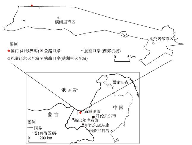
Border ports are the key nodes for economic cooperation among the sovereign countries at the Belt and Road Initiative. This study takes Manzhouli, the most closely connected port city on the Sino-Russian border, as an example. Firstly, by constructing the Modified Dynamic Concentration Index (MDCI), this study divided the process of the port-city relationship in Manzhouli into five stages: low level balanced development stage (1979-1987), port development slightly faster than the urban development stage (1988-1997), port development significantly faster than the city development stage (1998-2005), city development slightly faster than the port development stage (2006-2015), and new abrupt change point of port-city relationship (2016-2017). Secondly, the vector autoregressive model (VAR) is used to analyze the degree of influence at national, regional, local and individual scales on the Manzhouli port-city relationship. The research shows that in the whole period, the influence of different scales is manifested as national scale > individual scale > local scale > regional scale; at low level balanced development stage, the influence of national scale is larger, while that of regional, local and individual scales has less impact; at port development slightly faster than the urban development stage, with national scale as the main factor, the influence of Russia is slightly greater than that of China, and that of other scales is small; at port development significantly faster than the city development stage, all the national, regional and individual scales play an important role, and the role is relatively balanced; at city development slightly faster than the port development stage, the role of national, regional and local scales is more obvious, and the impact of individual scale is weakened. Among them, the regional scale has the largest impact, and the national scale (Russia) > local scale > national scale (China) > individual scale; at the new abrupt change point of port-city relationship, the influence of individual and national scales is larger, while that of regional and local scales is smaller. Finally, this study makes full use of both quantitative and qualitative analysis methods, such as VAR model and in-depth interview, to examine the influence mechanism of national, regional, local and individual scales on the evolution of port-city relationship in a full period and in stages. This study can provide a multi-scale perspective for Manzhouli to promote its benign development of port-city relationship, and also provide a reference for the development of port-city interaction in the vast border areas of China.
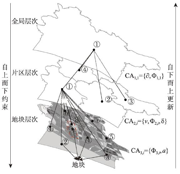
Urban planning plays an important guiding role in land use change. The planning at all levels supports and complements each other, and influences the evolution of land-use pattern from top to bottom. Vector cellular automata, which takes irregular geographical entities as its basic units, can express the objective and complicated urban land use structure in a more realistic way, and has become one of the focus in the land use change research. However, when we face urban planning with the characteristics of hierarchical synergy, spatial guidance and controlled conductivity, some key issues are highlighted, such as the establishment of CA hierarchical system, the construction of hierarchical synergy and the acquisition of transition rules. After constructing the multilevel vector CA model, we chose Jiangyin City as the study area and its land use data covering the years 2007, 2012 and 2017 as the basic data to simulate the land use changes from 2012 to 2017. On the basis of multilevel vector cellular automata model, through the comparative analysis between the simulation results and the current situation of land use in 2017, the individual parameters of the model were modified to further improve the feasibility and applicability of the model, and then the urban land use pattern in 2022 was predicted. The simulation results indicated that the development of construction land in Central District has become saturated, while the expansions of construction land in Chengnan District, Chengdongnan District and Chengdong District were obvious. From an overall perspective, there was a tendency to gradually form a three-level urban-rural spatial settlement system "central city area-urban agglomeration-village". Using FoM index, we concluded that the simulation results had great simulation precision and the model had high feasibility and applicability, because the FoM values of the whole city and each district were almost greater than or close to 0.21. This shows that the simulation results are more accurate and the model is more effective in the simulation of land use change based on urban planning.
Resource-based cities refer to the cities where the exploiting and processing of natural resources, such as minerals and forests, dominate industrial development. This special type of city is obviously staged during its development. From a new perspective of urban spatial structure, this paper quantitatively splits the development stages of resource-based cities based on the data of night lights images and uses the methods, such as the threshold panel model and non-parametric estimation. To delve into the impacts of resource-based industries on the evolution of urban spatial structure, as well as the timing of transformation policy design, different effects of the spatial agglomeration of central urban areas on urban growth and transformation by development stages are also analyzed in this paper. The results suggest that: the resource-based cities are relatively internally fragmented with noticeable differences among resource types and individuals, such as oil and gas resource type, and ferrous metal resource type. This paper attempts to adopt the proportion of mining employees as the indicator. Some 1.9% and 31.0% can act as the tipping points to divide different development stages of resource-based cities. The resource-based cities are split into four stages of development given two threshold values. In various stages of development, the correlation between the concentration of social and economic factors in the central urban area and the urban economic growth is noticeably different. Furthermore, 'the mature stage' has acted as a critical turning phase in the transformation of resource-based cities.

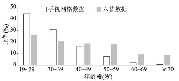
Job-housing relationship in city has always been a concern of scholars. Excess commuting is a well-accepted concept for evaluating commuting efficiency and potential of optimizing it. By calculating difference between observed commute and theoretical minimum commute, excess commuting can measure to what extent the commute of a city is wasted. Studies on excess commuting are rather scarce in China, especially in perspective of different age groups. Using the mobile phone grid data in September 2017 in Shanghai, this paper analyzes the residential locations, job locations, and commuting distances of three age groups, namely, the young, the middle and the old. To calculate their excess commuting, a modified algorithm is devised, simulating individuals exchanging their residences based on the principle of Pareto Optimality, so that no one has to sacrifice their status quo. The new method also uses large-scale individual data instead of small-scale aggregate origin-destination data adopted in the traditional linear programming method. The job-housing relationships under the optimal commuting are estimated and compared between age groups. The results show that: (1) There is an evident inter-generational differentiation in the job-housing relationships. The young people are the disadvantaged group with the longest commute distances and the farthest residence locations from the city center; the elderly are the dominant group with the shortest commute distances and the closest residence locations from the city center; the middle-aged are in-between. (2) The excess commuting rate in Shanghai is 69%, indicating a large potential in optimizing the job-housing relationships. (3) The benefits of the optimization are immense: the average commuting distance declines, the inter-generational differentiation moderates, and the spatial structure of population age becomes more balanced. (4) The young group will benefit most from this process. It is suggested that the spatial planning and policy making of Shanghai should set a target for an ideal spatial structure of the urban population age, so as to increase the fluidity of the job and housing spaces, youthen the city center, and make the perimeter areas more livable for the middle-age and old people.
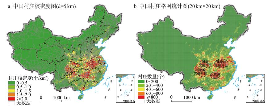
Village is the object of rural governance and revitalization. It is of great scientific value to carry out the research on the spatial distribution characteristics and influencing factors for comprehensively promoting the implementation of the rural revitalization strategy. This study systematically integrated the multi-source data such as the longitude and latitude coordinates of the village, geo-environment, traffic conditions and socio-economic level, and comprehensively applied spatial analysis, kernel density estimation and Ripley's K-function to describe the spatial distribution characteristics of Chinese villages and identify the influencing factors of village spatial differentiation. The results demonstrated that the evolution of villages follows the life cycle laws of formation, development, stability, decline, and revitalization, which is affected by the natural geographical environment and human, social, and economic factors. The speed, intensity, direction, and outcome of village evolution vary across regions over time. Further analysis results showed that the distribution density of villages in China is 0.353 per square kilometer. Overall, the number of villages in China is larger in the south than in the north, and larger in the east than in the west, and characterized by agglomeration in the southeast and dispersion in the northwest. Villages are most densely distributed in the middle and lower reaches of the Yangtze River and the Huaihe River Basin. With Hu's line as the boundary, the density of villages in the southeast is higher than that in the northwest. The Moran indexes of the kernel density of villages on the scales of province, county and township are 0.580, 0.861 and 0.910, respectively, showing obvious spatial aggregation characteristics. The spatial distribution of villages in each province presents an inverted U-shaped pattern, and the difference is obvious between provinces. The distribution pattern of Chinese villages is the result of the interactive coupling of geographical environment, location conditions, and social and economic factors. The spatial distribution of Chinese villages is relatively concentrated under the conditions of a slope of 6°-8°, an altitude of less than 200 m, rainfall of 1100-1200 mm, average annual temperature of 15-19 ℃, and anthropogenic soil and cultivated vegetation. The spatial distribution of villages is clustered along roads and rivers. The density of villages in the buffer zone of 100-300 m around roads and rivers is the largest, and gradually decreases as the buffer distance increases. Under the background of comprehensively promoting the strategy of rural revitalization, it is urgent to systematically analyze the causes and dynamic mechanism of rural recession, identify the geographical distribution and types of declining villages, and explore the feasible ways and regional models of rural revitalization.
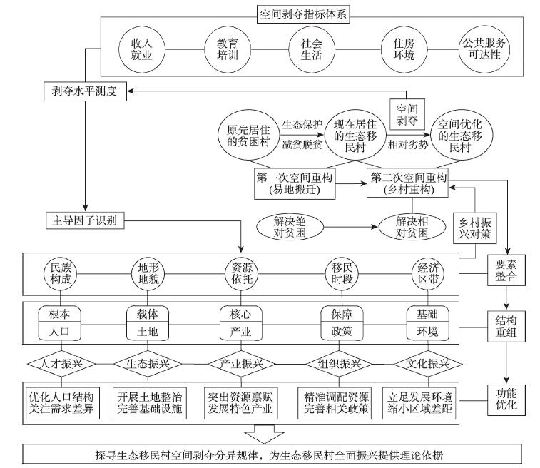
Eco-migrant village is a special type of village with the dual significance of poverty alleviation and ecological protection, as well as the indispensable and crucial object for rural revitalization. The spatial deprivation (SD), which resulted from the process of spatial reconstruction, is a new problem emerging in the course of eco-migrant villages revitalization and sustainable development. In order to explore the rule of the SD, this paper constructs a spatial deprivation index (SDI) system with income and employment, education and training, social life, living environment and accessibility of public services as the main contents, based on the data of 70 eco-migrant villages (EMV) of Ningxia in 2017, calculates EMVs' SDI value, and detects the impact factors by geographical weighted regression and GeoDetector. The results show that: (1) the overall level of SD of EMVs is low, but the total index means is 0.023 higher than that of non-EMVs. (2) The spatial and temporal variations of EMVs' SDI are obvious, presenting a time trend of "low - rise - decline" and a spatial distribution pattern of "the lowest in the north - the highest in the middle - the second highest in the south". (3) Ethnic composition, terrain and landform, migration period, essential resources and economic zone are critical factors affecting the SD of EMVs, in which the first three have explanatory capacity of the total SDI, being 22.4%, 10.6% and 14.0%, respectively. SD measurement provides a new objective basis for evaluating production and life of eco-migrants, adjusting and refining policies, so that relevant departments can optimize and reallocate the spatial resources of EMVs to increase their ability and opportunities, and promote the overall revitalization of EMVs.
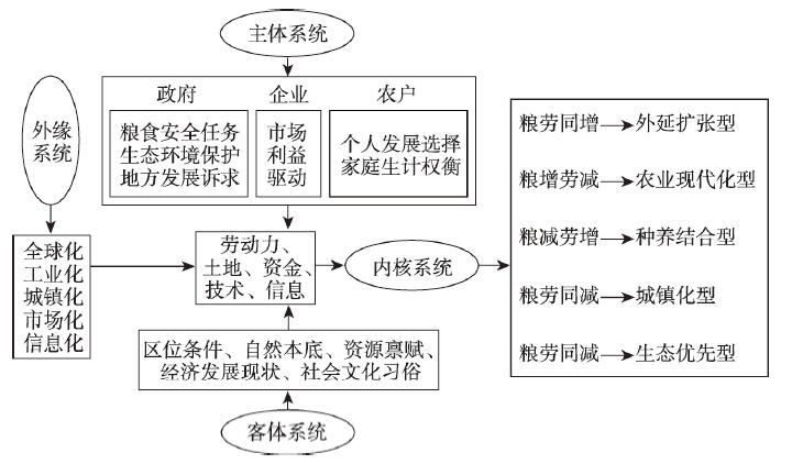
Rural revitalization needs to recognize and address the diversity of rural areas. Based on statistical data of grain yield and agricultural labor, this paper analyzes the coupled modes of the changes of grain yield and agricultural labor as well as their representations of rural development typology of 183 counties in Northeast China by using standard deviation ellipse, non-parametric test, and so on. The results show that: (1) during 2001-2015, the coupled mode of grain yield and agricultural labor changes of the whole study region turned in 2008. During 2001-2008, its grain yield increased while agricultural labor decreased; but during 2008-2015, both its grain yield and agricultural labor increased. Actually, this is due to degradation that resulted from the comprehensive interactions of many factors. (2) At county level, the proportion of grain yield increased while agricultural labor decreased counties in Northeast China shrank from 45.90% in 2001-2008 to 37.16% in 2008-2015, and the numbers of grain yield decreased while agricultural labor increased counties and grain yield and agricultural labor both decreased counties grew obviously. Spatially, the coupled modes of grain yield and agricultural labor changes evolved in differentiated patterns. (3) Based on the coupled modes of grain yield and agricultural labor changes and other supplementary indicators, this paper classifies the rural development typology at county level in Northeast China into five categories: extensive expansion type, agriculture modernization type, planting-breeding incorporated type, urbanizing type, and eco-environment prioritized type. The results show that these rural development types have certain hierarchical nature and present a structural evolution. Therefore, the coupled modes of grain yield and agricultural labor changes can represent the rural development typology well. (4) Different rural development types in Northeast China are facing different constraints and opportunities. In the light of these facts, this paper proposes the differential promotion strategies targeting specific rural development types. The approaches and strategies developed in this paper could be applied in other regions of China to analyze and address the diversity of rural areas.
Intangible cultural heritage is essentially the "embodied heritage" according to the fact that the human body is the subject and carrier of intangible heritage with the power of structuring and performing heritage. This article selects Shachong Aoyu Dance, an intangible cultural heritage in Guangzhou and its transmitters as the study case and research subject respectively. Based on the perspective of geographies of the body, a diachronic investigation on both the transmitters' training and performance was conducted to explore how their body techniques formed in the process of training and to interpret how they experience a performing process. In the space-time of training, transmitters who has higher proficiency of Aoyu Dance lead the relationship between old and new transmitters. The senior transmitters obtain a particular power in this space due to their professional body techniques. This relationship is formed based on hierarchical domination and discipline. The affectual flow between senior and junior transmitters is significantly impacted by their interactions, and it is also influenced by their biological characteristics. The junior transmitters, however, can overcome the negative impacts of the disciplinary relationship and the biological resistances of their bodies. Therefore, the junior transmitters can actively engage in the emotional and affectual interaction between the old transmitters, their own bodies and themselves. The social and cultural relation in the local village is the main force forming the politics of relationship during the training process. In the space-time of performance, the body is the core of transmitters' multisensory experience. The transmitters firstly perceive their surroundings in performing, and then establish a visual interaction with the audience through "gazing" and "being gazed". With the supplement of rhythm and sound, the transmitters can successfully connect themselves to the audience with full emotional and affectual circulations and contagions, which helps the transmitters increase the strength of performance and reciprocate these procedures. The bodies of transmitters are thus the premise and guarantee for the inheritance and performance of intangible cultural heritage. The body, carrying the rich local history and culture, occupies a central position in this complex space-time network that is characterized by multi-subject and multi-level.
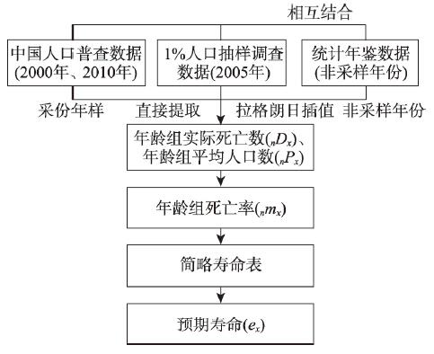
Age-specific mortality rate is a key parameter to estimate life expectancy based on age-group population. However, it is impossible to estimate life expectancy in non-sampling years (i.e., without census or 1% population sampling survey) due to the loss of age-specific mortality rate in statistical yearbooks. To estimate time-series life expectancy at China's provincial level in the non-sampling years, this paper firstly proposes a time-series estimation algorithm based on Lagrange interpolation by combining census data with population data from statistical yearbooks. We selected six provinces in central China as study areas and estimated provincial time-series life expectancy in non-sampling years by four algorithms, i.e., linear interpolation and quadratic polynomial interpolation in direct and indirect ways. And the absolute accuracy of estimating time-series life expectancy indicates that the accuracy of linear interpolation for proportions of population by age group (i.e. indirect method) is significantly higher than that of quadratic polynomial interpolation (i.e. indirect method) and time-series interpolation of life expectancy (i.e. direct method) based on two methods, which is proposed as a recommendation algorithm. This study provides a new and feasible way to acquire the provincial time-series life expectancy in non-sampling years, which lays a foundation for the more accurate trend analysis of life expectancy in China.