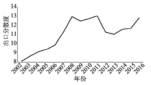
In the context of globalization, the interests of countries are intertwined and complicated, thus leads to multiple types of trade frictions. In order to protect domestic industries, some countries frequently set up trade protection barriers to restrict Chinese exports, which has a significant impact on China's economic development. Therefore, it is crucial for us to clarify the impact of trade protection barriers on regional export expanding processes in China. Based on the data of the China Customs Database from 2002 to 2016, this article focuses on the expanding path of Chinese export products by integrating the supply and demand perspectives into the same framework. In addition to the introduction to trade barriers set in the demand market as external forces, we also take the external market relatedness effect into consideration, which enriches traditional export spillover mechanisms. The main findings are as follows: (1) With the process of product upgrading, Chinese export destination structure is gradually leaning to emerging economies. Eastern and Central China, which expand their exporting portfolio by exporting more technology-intensive and capital-intensive products, are main contributors to this process. (2) The evolution path of Chinese export products presents typical path dependence characteristics composed of market linkages and technological linkages. In comparison, market linkages, which have been formerly neglected, are more vital to the expanding process of Chinese export market. (3) Multiple trade barriers will inhibit export expanding by cutting off channels for products entry, thereby breaking the region's original export expanding routes. (4) External shocks have a common effect on expanding mechanisms of regional export products by weakening the path dependence of technological linkages and market linkages. In conclusion, absorbing foreign investment, regional economic cooperation and diversification of export product and destination structure are effective countermeasures against external shocks like trade barriers.
Based on the data released by UNESCO on international student mobility in tertiary education from 2001 to 2015, this paper draws on network science to construct a multidimensional weighted directed network heterogeneity model. This model combines the GIS spatial analysis method and the negative binomial regression model to study spatiotemporal evolution and factors influencing international student mobility networks. The results are as follows. First, in terms of the evolutionary characteristics of time series, the linkages of international student mobility networks have increased from 4921 to 9137, and its average weighted degree centrality has rapidly increased from 8004 to 20,834, which indicates that both the number of international students and the choices of overseas routines are mounting. Second, in terms of the topological structure, it has evolved from a single core comprising the United States into dual cores comprising the United States and China. Gradually, Asian countries have become the main body of international student mobility networks, while the centrality of European countries has reduced. Thirdly, in terms of spatial structure, the international student mobility network has a significant core-periphery structure and hierarchical characteristics. The countries in the core, strong semi-periphery and semi-periphery alternate with countries from other tiers. The spatial patterns of the international student mobility network "from east to west, and from south to north" are changing. China and Australia have become the new regional centers of international student mobility networks, meaning that regionalization has become an important trend. Finally, regression analysis shows that the flow of international students correlates positively with the quality of higher education in destination countries, the number of students in colleges and universities, the per capita GDP, the historical links connection between the destination country and the country of origin, and the level of globalization. Geographical distance and linguistic proximity have a significant negative correlation with the flow of international students, indicating that the impediment of language is rapidly weakening, while geographical distance still hinders student mobility.
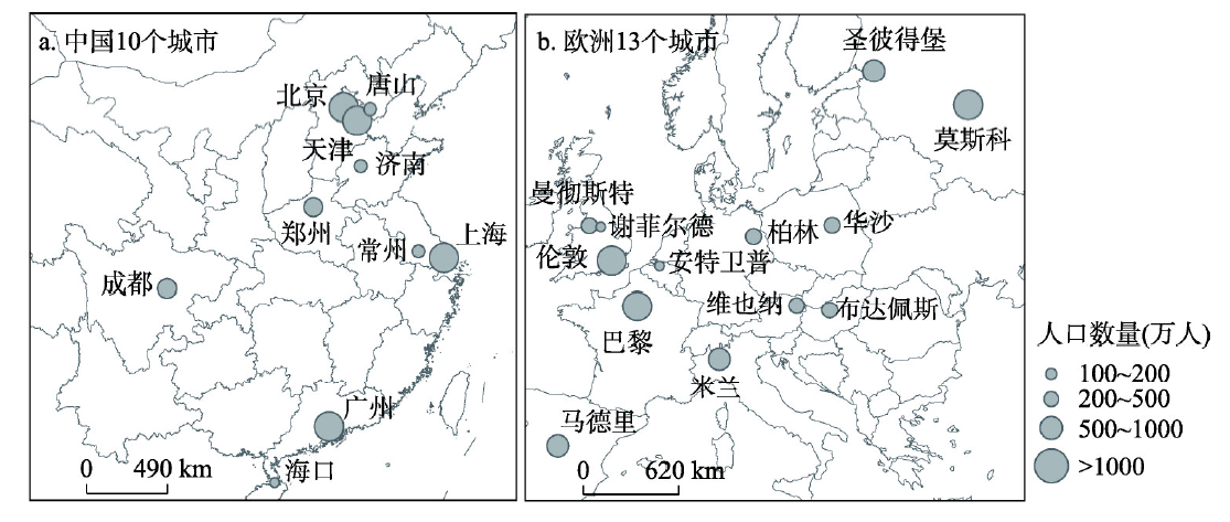
Exploring the relationship between urban spatial growth and population density change is the basis of urban sustainable development research, which is of great significance for formulating effective land policies to promote urban compact development. The research selected 23 cities with a population of more than 1 million in China and Europe as the study areas. Based on the land use and population data in the study areas in 1990, 2000, and 2014, the research calculated the growth rate of sample urban space during each period, and the urban compactness index was then established to divide the urban spatial growth mode into compact type, maintenance type and spread type. The characteristics of spatial growth, population density change, and their relationship were further discussed. The results are as follows: (1) Population density decline is widespread in cities of China and Europe. Population density in cities of China is relatively high, and the rate of decline is fast, whereas population density in cities of Europe is relatively low and the rate of decline is slow. From 1990 to 2014, the growth rate of urban spatial radius in China was significantly higher than that in Europe. There is a strong negative correlation between the growth rate of urban space and the change rate of population density (with a Pearson's r of -0.693). (2) From 1990 to 2000, most of the sample cities' spatial growth mode were compact. From 2000 to 2014, most Chinese cities' spatial growth mode transformed into spread type and rate of population density decline increased. By contrast, European cities' spatial growth mode maintained to be compact or transformed into maintenance, and the rate of population density decline decreased. (3) Compact spatial growth does not necessarily lead to an increase in population density, but it tends to lower the rate of population density decline, relative to spread spatial growth. The comparative analysis of Chinese and European cities shows that if cities maintain a compact spatial growth mode, the rate of population density will be lowered. If cities' spatial growth mode transforms from compact to spread, it will intensify the decline of urban population density over time.
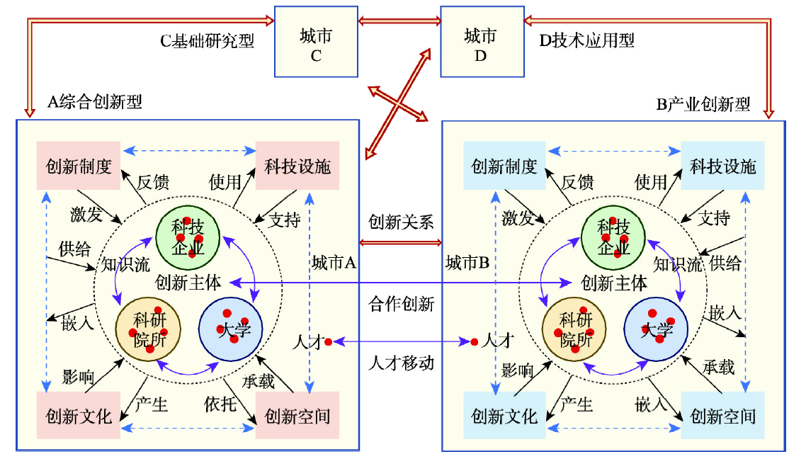
The interactive relationships between cities in the knowledge economy era have attracted much attention. Researchers have applied a range of methods to explore intercity innovative relationships and associated network characteristics. It nevertheless remains unclear just how intercity innovative relationships can be theoretically constructed based on knowledge flow space and how further scientific simulation methods can be designed. Research questions in this area have rarely been explored in detail, an issue which has inevitably placed obstacles on further exploration. A framework for the theoretical construction of intercity innovative relationships is presented in this study; the basis for this research is that an intercity innovation network is essentially a 'soft network', distinct from a 'hard network'. These interconnections are founded on a subjective relationship construction process and therefore necessitate scale transformation from 'point-point' connections between innovative subjects in different cities with respect to 'city-city' interactions. At the same time, this transformation process is prone to exaggerations and deviations from objective intercity innovative relationships and therefore exerts considerable influence on the accuracy of results such that constructions must be entirely theoretical. Four construction methods for intercity innovative relationships and network simulation are summarized in this study, including an intercity undirected network based on cross-city co-operations between scientific and technological achievements, an intercity directed network based on the cross-city transfer of scientific and technological achievements, an intercity innovation network based on the cross-city flow of high-end talents, and an intercity innovation network based on the multi-city distribution of innovative enterprises and institutions. Simulation tests were then undertaken using relevant data to reflect aspects of these relationships. The results of this analysis are conducive to further exploration of global and regional innovative spatial patterns from the perspective of urban geography and intercity relationships and provide a theoretical and methodological foundation for further research on intercity innovation networks.
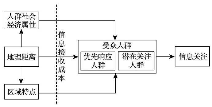
In the era of "internet society" premised upon new telecommunications and information technologies, there is a perennial debate on whether geographical distance still plays a role in spatial phenomena, and this has been deemed as a cornerstone of geographical research. To empirically tackle this recurring conundrum, this paper proposes an analytical framework to interpret how geographical distance affects information dissemination, which has always been portrayed to be instantaneous spreading across space by information technique. To be specific, we suggest that closer geographical distance could lead to better information dissemination through two entwined paths: geographical proximity is related to geographical and cultural homogeneity on the one hand, and lowers the cost of physical transport and non-physical links, which would facilitate intercity dissemination, on the other hand. As the former has been widely recognized in previous studies, in this paper we mainly focus on testing the latter path. That is, the influence of geographical distance on the attention to information still remains, after controlling regional characteristics and socio-economic attributes of the audiences. Taking two Chinese TV shows as examples, this paper measures the degree of information attention based on the Baidu Index, as well as maps its spatio-temporal changes. To understand the impact of the changing role of geographical distance over time, we perform OLS regressions at four phases from the first broadcasting of the two programs. The result verifies that geographical distance still plays a significant role in the attention and reception of information during the entire period. The degree of audience's attention decreases as the distance from programs' birthplaces increases. The resistance of geographical distance, however, gradually decays over time. Furthermore, these results are robust at both provincial and city scales, with two different programs having similar findings. The retained effects of geographical distance on the cost of information attention and reception helps explain our results. In other words, the law of geographical distance decay and geographical embeddedness is remaining, even though internet technique enables instant information transition. We therefore argue that the prognosis of "death of distance" or "end of geography" is far from the reality - at least from our empirical analysis, albeit in the internet society.
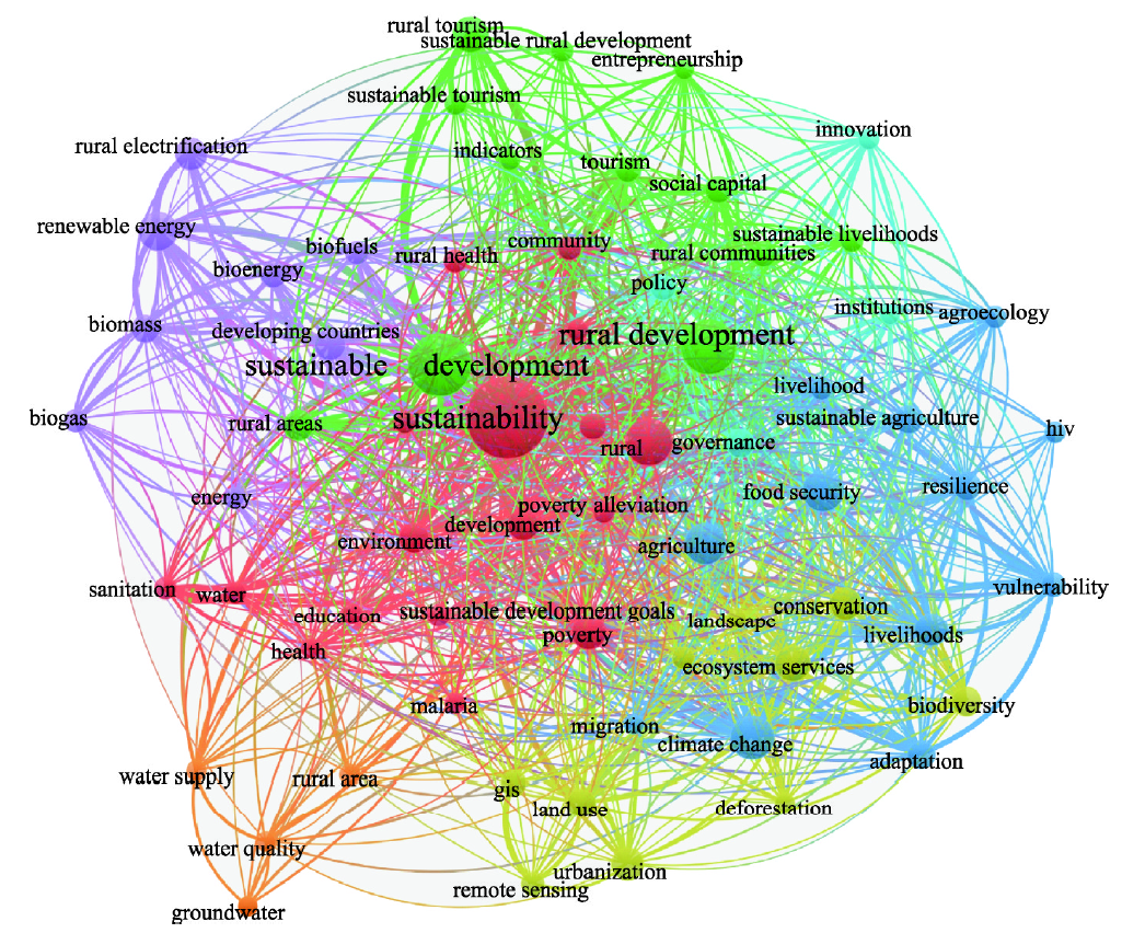
In the face of global environmental challenges, sustainable development has received much attention worldwide, and sustainability science has emerged in the 21st century as a globally well-recognized new area of science. Rural sustainability science, as an important part of sustainability science, is a use-inspired science aimed at understanding and improving the dynamic relationship between people and the rural environment from a transdisciplinary and multiscale perspective. In tandem with urban sustainability science, it provides much needed scientific support for dealing with rural decline and promoting rural sustainable development. In this paper, we first discuss the concepts of sustainability, rural sustainability, and rural sustainability science, and then propose a transdisciplinary integrated framework of rural sustainability science that focuses on agricultural sustainability, community sustainability, and rural human well-being. China is a nation with deep rural roots, complex problems involving interactions among agriculture, farmers, and villages, and huge urban-rural socioeconomic gaps. Since the reform and opening-up in 1978, China's rural areas have developed rapidly, but they still face numerous tough challenges. Rural revitalization strategies are needed for promoting the rural transition toward sustainability, but the necessary scientific basis and appropriate guidelines for formulating such strategies are still lacking. We argue that rural sustainability science can provide theoretical, technical, and decision-making support for the implementation of rural revitalization strategies. Our analysis of the current status of China's rural sustainable development indicates that the transition to sustainability is urgently needed, and so is the science that guides the transition. To address these problems, we call for transdisciplinary research that couples rural society and its environment, focusing on nine core issues in line with the needs of China's rural development and aiming to transfer knowledge of rural sustainability into local adaptive actions.
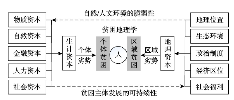
Poverty includes regional poverty and individual poverty, both of which are featured by multidimensional concept. Regional multidimensional poverty (RMP) is a major theme and content in poverty geography. Because of harsh natural environment, vulnerable economy and inadequate public services, severely impoverished areas (SIAs) are typical and highlighted areas of RMP, which have been the biggest obstacle to poverty alleviation in China. Based on the theory of spatial poverty, this paper defines the notion of impoverished areal system (IAS) and regional multidimensional poverty (RMP), explores their internal connections and proposes the evaluation indictors and measurement method for RMP. Taking 334 severely impoverished counties as research samples, we analyze the multidimensional poverty patterns of SIAs in 2016 by BP neural network model and exploratory spatial data analysis (ESDA). Results show that: (1) RMP is an external manifestation of the coupling imbalance of "human", "environment" and "industry" in the evolution of IAS. It reveals regional disadvantages in natural environment, economic development and social welfare, corresponding to natural poverty, economic poverty and welfare poverty, respectively. (2) The most severely impoverished county, with the poorest services and infrastructure, is found in the Qinghai-Tibet Plateau. From a single dimension of regional poverty, the Welfare Poverty Index (WPI) > Economic Poverty Index (EPI) > Natural Poverty Index (NPI) in the SIAs, whose average is 2.77, 2.66 and 1.89, respectively, indicating that the lack of social welfare and public services for the poor has become the prominent problem in the SIAs. From the perspective of multidimensional poverty, the Qinghai-Tibet Plateau is a high agglomeration region or "hot spot" of RMP, which is significantly higher than other areas in terms of natural poverty, economic poverty and welfare poverty. (3) Both RMP and individual multidimensional poverty are effective measures of poverty targeting. Their matching coefficient (M) can help us to judge the poverty status of some specific areas, e.g., RMP is superior to individual multidimensional poverty in the remote areas, extremely fragile ecological environment and obvious regional disadvantage, where the matching coefficient (M) is higher. RMP can more objectively reflect the true level of geographical capitals, effectively target poor areas and identify determinant impoverishing factors.
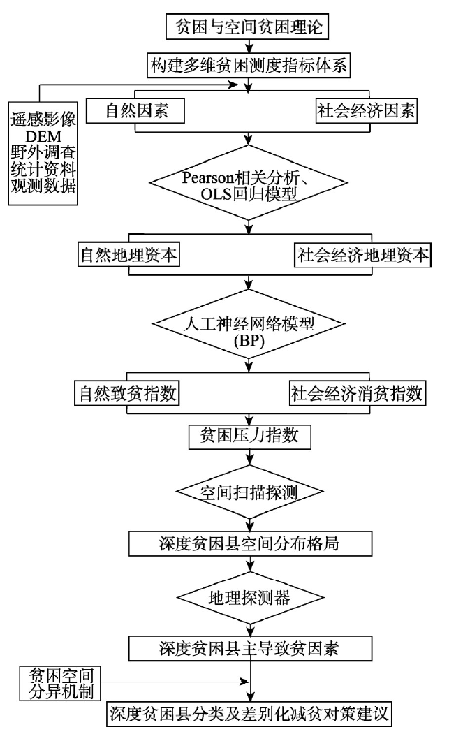
Poverty has appeared as one of the long-term predicaments facing human development in the 21st century. The essence of extreme poverty is absolute poverty, where individuals experience long-term shortages of essential resources or suffer from harsh environment. Extreme poverty is the priority for poverty alleviation and the tough row to hoe. We select the major poverty influencing factors from natural and social factors to build an evaluation index system based on spatial poverty and related theories. First, we use Pearson correlation analysis to differentiate poverty impoverishing and alleviation factors. Then, we use GIS and back propagating neural networks to define a natural impoverishing index (NII) and social economic poverty alleviation index (SEPAI), respectively, at provincial, municipal, and county levels. We then calculate a poverty pressure index (PPI) at provincial, municipal, and county levels by combining NII and SEPAI, and explore poverty spatial characteristics. We used the flexible spatial scanning statistical method to identify the severely impoverished counties among the poverty-stricken counties with PPI>1.63, which had higher poverty rate and difficulty in poverty alleviation. Finally, we diagnose dominant factors that differentiate severely impoverished counties, and identify the dynamic mechanism of regional extreme poverty differentiation using the geodetector model. Besides, we construct a theoretical basis for anti-poverty in rural China. The results show that NII and PPI spatial distributions are highly consistent at provincial, municipal, and county levels, with a significant distribution pattern: high in eastern China and low in western China. In contrast, SEPAI has relatively low spatial consistency at provincial, municipal, and county levels. The PPI poverty distribution pattern tends toward large dispersion, small aggregation dividing across the Heihe-Bose Line. A total of 655 poverty-stricken counties were identified, mainly distributed in major ecologically functional and agricultural production areas in China. High risk areas identified by spatial scanning are mainly distributed in the northwest, southwest minority, and border areas. We also identified 208 severely impoverished counties, mostly located in inter-provincial fringe areas. The geodetector model identified seven dominant impoverishing factors, with significant differences between the four identified rural extreme poverty types: terrain detail oriented, location traffic dominated, economic income leading, and ecoenvironment constrained regions.
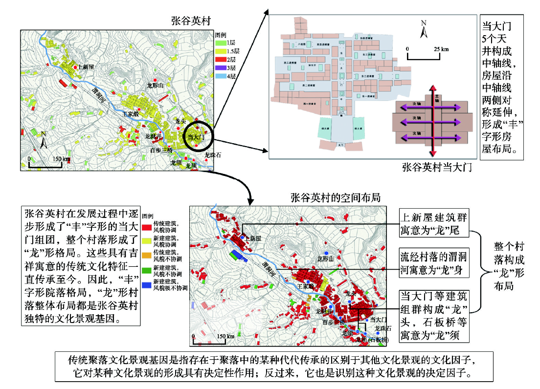
The concept of cultural landscape genes of traditional settlements (CLGTS) was proposed by Chinese scholars in 2003. Since then, CLGTS has been playing a key role in capturing the deep-level geographic features of traditional settlements. However, there is a lack of work on covering CLGTS from the perspective of semiotics. Now, people are often involved in difficulties when they are trying to explore the nature of cultural landscapes of traditional settlements through using CLGTS. Obviously, it is of great significance to explore the concepts and methods of semiotic mechanism of CLGTS under the support of semiology. To lock this issue, we outline the dialectical features of CLGTS through the following five aspects. (1) For a given traditional settlement, its whole image at the macro-scale is in accordance with its cultural landscape genes at the micro-scale. (2) For the cultural landscape gene of a given traditional settlement, its core characterizations are in accordance with its appearance features. (3) For a given traditional settlement, its self-updating mechanism at local scale is in accordance with its global characterizations. (4) CLGTS can be treated as the scientific analysis method merged with the quantitative and qualitative approaches for dissecting the cultural features of traditional settlements. (5) For a given traditional settlement, its outstanding features of cultural landscape are in accordance with its rich cultural connotation. Then, this work proves the diversity of forms and complexity of spatial structures of CLGTS through ample examples. To some extent, this reveals the nonlinearity, self-organization, as well as self-iteration features of CLGTS. Based on the above, this research presents a conceptual framework of semiotic mechanism of CLGTS. Within the framework, we further summarize the symbols' main features, classifications, and expression ways of CLGTS. Through this work, we make clear the requisite theoretical conditions of making symbols of CLGTS by employing GIS. Ultimately, based on the aforementioned conceptual framework, this paper develops a prototype program for making symbols of CLGTS. The test results of the prototype program with a case of ancient village of Hunan Province show that it can run well in serving to establish a symbol database of CLGTS for a given region. Hence, this research proves that semiotic mechanism of CLGTS will make sense of perfecting the theory of CLGTS and forwarding its digital protection.
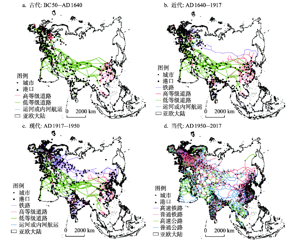
The Eurasian continent is the center of the world political arena and plays a vital role in the shifting geopolitical orders in human history. Moreover, it is the main area where the Belt and Road Initiative deploys. Relevant studies of the initiative focus more on synchronic analysis and less on the long-term evolution of land and sea transport patterns. Therefore, the goal of this paper is to conduct a preliminary analysis on the spatial evolution of Eurasian land and sea transport based on four periods including ancient period (BC 50-AD 1640), early modern period (AD 1640-1917), late modern period (AD 1917-1950) and contemporary times (AD 1950-2017). In this way, the historical role and strategic deployment of the Belt and Road Initiative could be further uncovered. Study shows that the degree of connectivity in various regions has steadily increased since the early modern times. And the accessibility tends to be equalized at the continental scale, while the land and sea transport networks both show a trend of polarization at the sub-continental scale, with a range of key hubs becoming more prominent in coordinating the flows among different areas. Furthermore, transport lines with strategic importance have significant influence on the accessibility of different areas as well as the geopolitical order of the continent. According to the result, the significance of the Belt and Road Initiative should be understood on a much longer time scale. Meanwhile, decentralized cooperative strategies should be promoted, existing key hubs should be made full use of, and a range or new hubs should further be developed. In addition, arteries such as the Eurasian High-Speed Railway should be constructed to promote the interconnection among various regions in Eurasia so as to gain a strategic advantage in the geopolitical arena. The innovation of this study is analyzing the evolution of Eurasian land and sea transport on a time scale of more than 2000 years.
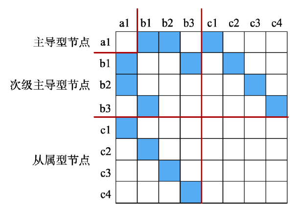
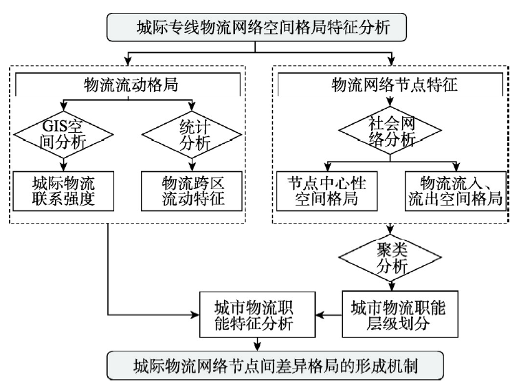
Freight logistics is one of the most important socioeconomic connection elements between regions. The intercity logistics connection is an important perspective to understand regional production-consumption relationship and urban spatial structure. However, due to the lack of data and methods, few studies can effectively reveal the intercity logistics network pattern at the nation level. With the development and application of Internet and data science, the logistics resources and data integrated by the fourth party logistics platform provide new data source and research foundation for logistics studies. Drawing online less-than-truckload logistics transaction data for 3 months from November 2017 to January 2018, from the largest 4th party logistics (4PL) platform in China, this research aims to explore the intercity logistics connection pattern and urban logistics function differences. The outbound and inbound transaction numbers were calculated first for each prefecture-level city. With the approach of social network analysis (SNA), the logistics connection intensity and corresponding centrality were then computed and visualized for each city in the network. The research results show that: (1) the intercity logistics landscape roughly coincides with interregional socio-economic development. Taking three metropolises (i.e., Beijing-Tianjin-Hebei, Yangtze River Delta, and Pearl River Delta) as core triangle corridors, the national logistics connection pattern decreases from coastal area to inland areas. (2) Logistics activities are characterized by significant cross-regional flow. Active are intercity logistics shipment activities within the threshold of 1200 km distance. (3) According to the less-than-truckload logistics (LTL) network pattern, cities in China could be further divided into five categories, namely the national primary logistics city, national logistics center cities, national logistics node cities, regional logistics center cities and local logistics cities. These conclusions are expected to, from the perspective of intercity logistics connections, support national, provincial and city governments to make spatial planning and logistics planning.
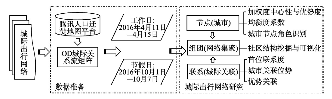
The differences of residents' travel purpose, travel time and regional attribute will lead to the heterogeneity of travel behavior. Working days and holidays have completely different time attributes, and the travel purpose is quite different. Therefore, comparing them has become an important way to reveal the inter-city travel network from different perspectives. Using migration data inferred from passenger travels during working days in April (11-15 April, 2016) and National Day golden week (1-7 October, 2016) from Tencent Location Big Data, this paper made a comparison of the spatial structure of inter-city travel network during weekdays and holiday in China. The results are as follows: (1) The average daily inter-city residents' travel scale during the golden week was significantly higher than that during the weekdays, but the travel distance and network clustering degree were significantly lower than the latter. (2) The two networks form three types of cross-regional group, adjacent group and provincial group. During the golden week, the number of cross-regional groups is significantly lower compared with weekdays, the number of regional and local hub cities is more than that of weekdays, and the number of adjacent groups and provincial groups is significantly higher than that of weekdays. (3) On weekdays, the three major cities of Beijing, Shanghai and Guangzhou have a prominent core position, and the function of tourism and transportation hub is highlighted in the golden week. (4) Weekday intercity network to cross-regional links, and the golden week is showing a clear spatial proximity effect, and formed a provincial capital as the center, the provincial travel core-peripheral mode. The structure and difference of inter-city travel network in the two periods are influenced by many factors, including geographical proximity, administrative division (proximity of cultural system), travel distance and travel purpose.
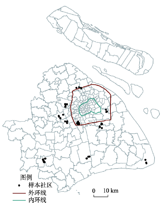
Socio-spatial segregation is an important research topic in urban social geography. Most of the research pays more attention to the residential differentiation and segregation of different groups and proposes that geographical segregation exacerbates the social isolation between disadvantaged groups and other social classes. However, most existing research ignores the spatial differentiation that people suffer from in their daily lives and discusses little about segregation in nonresidential spaces. In the context of increasing mobility, even residents living in the same neighborhood face different degrees of segregation due to differences in the choice of venues, resulting in a lower likelihood of social interaction. Therefore, recent research suggests that it is necessary to pay attention to the differentiation and segregation faced by residents in daily activity spaces and to understand social space from a more comprehensive perspective. However, due to the constraints of data and methods, only a few prior studies have quantitatively measured the activity space segregation of residents living in the same neighborhoods. In particular, there is currently no research focusing on whether policy and planning can effectively reduce activity space segregation. This study intends to solve the problem of socio-spatial segregation in the daily lives of different residents in the same neighborhood through the measurement of activity space. Taking the suburbs of Shanghai as an example, this study analyzes the degree of overlap between residents and other social groups in activity spaces, calculates the "shared activity space" index among individuals, and calculates an individual-scale activity space differentiation index and isolation index on this basis to measure the isolation of different income groups within the community. This indicates that there is indeed segregation between different groups, and the degree of segregation is influenced by individual socio-economic attributes, the mix of residential groups, and the spatial distribution of urban facilities. Living in a neighborhood with high population density, a high social mix, a good community business configuration, and sufficient public space can indeed increase the sharing of residents' activity spaces, while nearby shopping centers will cause isolated activity spaces.
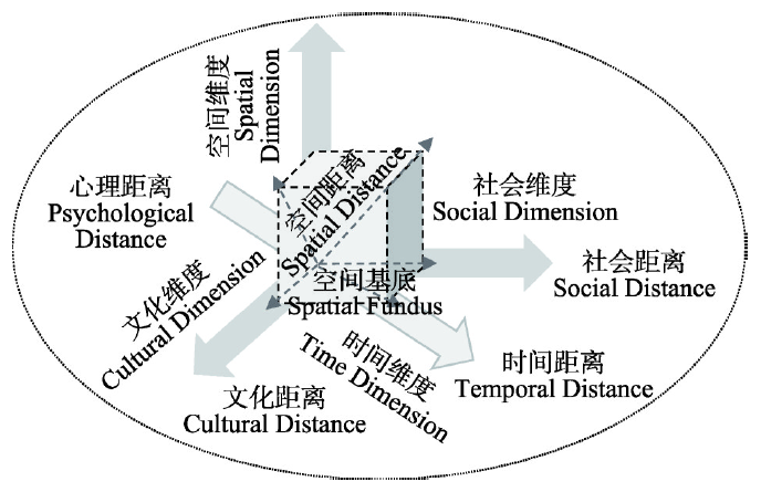
Distance is an important factor influencing all kinds of human spatial behavior and is also a major variable in exploring the laws of human behavior. However, the existing tourist destination decision model treats distance as a constraint condition, comprehensively discussing the frictional effect while ignoring the impacts of the catalytic effect of distance. This has led to a lack of theoretical and marketing practices. This study proposes the concept of distance desire to express the catalytic effect of distance. Based on its basic attribute of aesthetic emotion, the concept is subdivided into three dimensions: the cognitive dimension, the emotional dimension, and the travel motivation dimension. According to the characteristics of tourists' aesthetic demands, distance desire has been divided into three levels from the perspective of the modern aesthetic view, including the distance desire of game, distance desire of fashion and distance desire of adventure. The study further points out that distance desire is a tourist's interpretation of the meaning of distance. The development of distance desire provides a new explanation for tourist's motivation to travel. The pursuit of the poetic "far-away" by tourists is the essential pursuit of human beings to surpass themselves and is also an aesthetic salvation of individual resistance to alienation in a rapidly developing fluid society. Distance desire also provides a new perspective for understanding the essence of tourism. The aesthetic experience of the distance brought by tourism activities can satisfy the tourists' spiritual pursuit of harmony (differentiating the divisions caused by daily life), tolerance (differentiating respect and recognition) and independence (free construction of personality). Tourism is a form of aesthetic experience, during which tourists participate in constructing and reshaping their psychological structure, thus encouraging them to return to the real world and to reshape it within a harmonious, tolerant and independent aesthetic realm, thereby enhancing the quality of life of tourists individually and of humanity as a whole. By further discussing the relationship between distance desire and other behavioral variables, the basic interpretation framework of distance and tourist destination choice is eventually provided in this study. An in-depth study of distance desire can provide new explanations for the analysis of the tourist motivations in the era of globalization, provide new clues for the interpretation of the essence of tourism, provide a new understanding of the law of distance decay in tourist destination choice from a micro-individual perspective, provide possible theoretical explanations for a more comprehensive understanding of the distance dynamics in tourists' destination choices, provide the possibility to further improve and enhance the explanatory power and the predictability of the tourist destination decision model, and provide destination marketing organizations (DMOs) new ideas to develop targeted marketing strategies concerning cognitive distance.
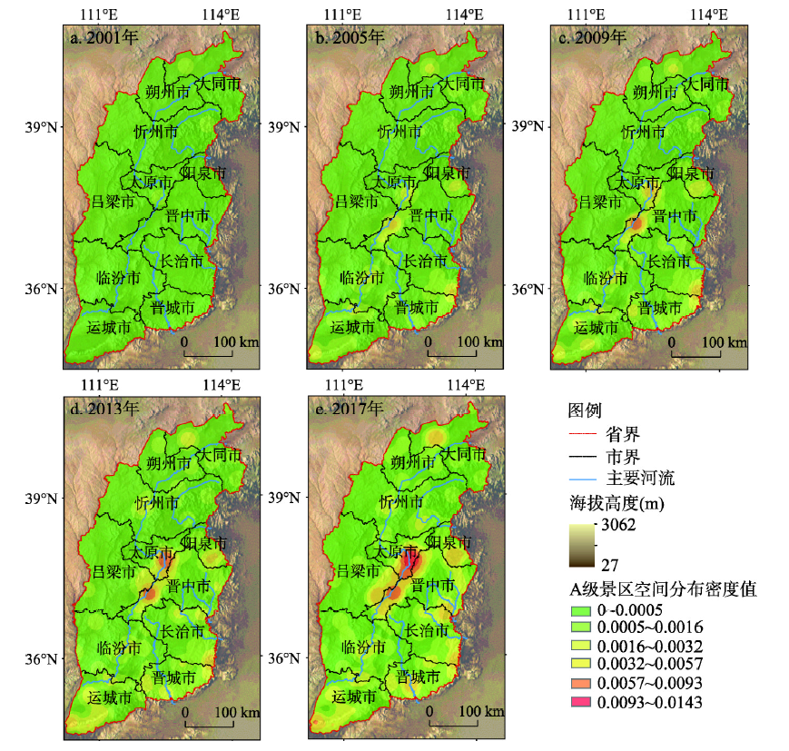
of spatial analysis technology of GIS as well as Geodetector are proposed to identify the spatial distribution and influencing factors of national A-level tourist attractions in Shanxi Province from 2001 to 2017, based on data from tourism administration network, Geospatial Data Cloud, government reports and statistical yearbooks. These influencing factors include socio-political factor (including related policies, resident population and traffic conditions), economic-industrial factor (including the proportion of three industries, tourism income and GDP) and natural environmental factor (including altitude, river system and average temperature). The results show that: (1) Dynamic factors, such as socio-political factor as well as economic-industrial factor, changed greatly, while static factors, such as natural environment factor, changed little; (2) Nine third-level influencing factors affected the spatial distribution of national A-level tourist attractions in Shanxi to different degrees, five of which, including related policies, resident population, traffic conditions, tourism income and GDP, were continuously strengthened from 2001 to 2017, while the proportion of three industries decreased in a fluctuating way. For the rest of third-level influencing factors, i.e. altitude, river system and average temperature, their influence on the spatial distribution of national A-level tourist attractions in the province remained relatively stable. (3) With respect of the evolution of national A-level tourist attractions in Shanxi from 2001 to 2017, the extent of impacts of the socio-political factor, one of the second-level factors, increased year by year and the factor became the most important, followed by the economic-industrial factor, while the natural environmental factor had the minimum influence. The results can provide a strong support for assessing and guiding the overall development of regional tourism, promoting the development of tourism, and providing a scientific method to optimize the spatial structure of tourist attractions and tourism industry upgrading.