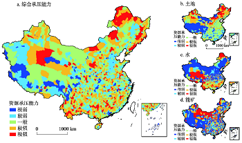
Relationship is a classic concern of geographical research, which is also a research field where China's human and economic geography has made notable contributions to international geographical research. The connotation of man-land relationship changes constantly during its dynamic evolution process. Therefore, a scientific evaluation on the status of modern man-land relationship in China is the basis for an accurate understanding of it with which paths of coordinating conflicts between man and land can be sought. Based on the territorial system theory of man-land relationship and a review of the new characteristics of modern man-land relationship in China, this study constructs a theoretical framework to make a comprehensive evaluation on man-land relations using the following four indicators: intensity of human activities, carrying capacity of core resources, ecological and environmental constraints, and openness of man-land system. Counties are taken as the basic spatial units in the evaluation. The following results are found: there are apparent differences between eastern and western China in terms of intensity of human activities and the distribution pattern of it follows the layout of core urban agglomerations; the carrying capacities of core resources take on a relatively dispersed spatial distribution; there is a high level of spatial mismatch between land, water, core energy resources, and the intensity of human activities, which intensifies the tension of regional man-land relationship; areas with strong ecological and environmental constrains are concentrated on both sides of the Heihe-Tengchong Line (also known as the Hu Huanyong Line) and in the southwestern part of the Qinghai-Tibet Plateau; overall, the level of openness of China's man-land system is not high, with relatively open areas mainly concentrated in economically developed regions. The evaluation results show that about 86% of the regions in China are faced an unstrained man-land relationship, but noticeable man-land conflicts are found in some areas, particularly in southeastern coastal areas. In the western region of China, man-land relationship is relatively unstrained though the level of man-land system evolution is low.
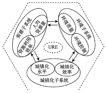
At present, urbanization and eco-environment coupling has become a research hotspot. Owing to the complexity of the coupling mechanism, as well as the limitation of mathematical statistics methods, the process simulation of urbanization and eco-environment coupling needs to be strengthened. Based on the systems science and cross-scale coupling theory, we can define the coupled urbanization and eco-environment system as a nonlinear open system with multiple feedbacks. Based on the above analysis, the progress of dynamic simulation for urbanization and eco-environment coupling is reviewed. (1) As dynamic simulation has become a trend, the relevant analysis of theory and mechanism is being improved. (2) Dynamic simulation technologies have shown a trend of diversified, refined, intelligent and integrated pattern. (3) The simulation application mainly focuses on three aspects, including multiple-case regions, multiple elements, local coupling and telecoupling, and regional synergy. In addition, we found some shortcomings. (1) The development and integration of basic theories are insufficient. (2) The method integration and data sharing is lagging. (3) The coupling relational chains and dynamic characteristics of the main control elements are not fully revealed. Besides, telecoupling simulation is not quantified and systematically integrated, and could not be effectively applied to spatial synergy. In future, we should promote the intersection of research networks, technology integration and data sharing, and then uncover the evolution process of coupling relational chains and the main control elements in urban agglomerations. Finally, we should build decision-making support systems for regional sustainable urbanization.
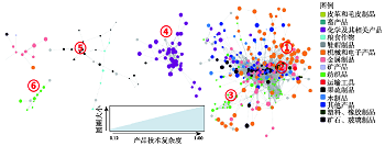
Regional development is the process of continuous evolution, transformation and upgrading of regional industries. Evolutionary economic geography emphasizes the process of endogenous development, but it ignores the path breaking brought by exogenous and institutional factors. Based on a firm-product level dataset on Chinese exports during 2000-2013, this paper examines the evolution pattern of China's exports space by aggregating firm-product level data to city-product level ones. This paper adopt the relatedness indicator, which is based on the co-occurrence of products in the export basket of countries. This paper adjusts and defines the indicator as the co-occurrence of two products at the firm level. Based on technological relatedness, this paper develops product space of China's exports, and explores whether the evolution of China's urban export is path dependence, and how those cities break existing path-dependent trajectories and create a new path. The conclusions of the study show that, firstly, the evolution of China's urban export products is affected by their original product structure and is characterized by the path dependence. Secondly, this research points out that the seemingly dominant path-dependent development trajectories can be broken through continuously improving external linkages, creating friendly environment of knowledge flow, and fostering an open-minded social and institutional context. Besides, the effects of these sets of variables vary across cities and industries. Specifically, technological relatedness played a more important role in the eastern and central China. Compared with labor intensive industries, technology intensive ones are more likely to depend on existing product structure. This paper points out that extra-regional linkages, related knowledge spillovers and open-minded institutional context have the potential to bring in and/or generate fresh know-how, which may enable cities to develop in a path-breaking way.
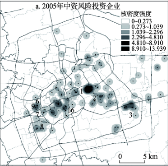
Venture capital firms (VCFs), target enterprises, and financial firms have close business relations, which are often manifested as the technology-capital coupling. How this coupling relation is mapped onto space, especially the urban internal space with high economic density, is imperative to an understanding of location significance and scalar consistency in geographic space. Using street block as the spatial unit of analysis, this study investigates the spatial pattern and "technology-capital" geographic proximity of Chinese and foreign-owned VCFs in Shanghai based on the cross-section data in 2005 and 2015. The analytical methods include kernel density estimation, temporal hot spots analysis method and spatial Tobit model. The empirical results are as follows. First, Chinese-funded VCFs are characterized by single centered agglomeration and "surface domain diffusion", while foreign-funded VCFs are characterized by polycentric agglomeration and "point domain diffusion". However, both types of VCFs tend to be in close proximity to the place where technology and capital are located. Second, VCFs tend to emphasize location proximity more to capital than to technology. In terms of location proximity to technology, VCFs have a closer relation with high-tech industries than with newly established enterprises. The differences between Chinese- and foreign-owned VCFs in geographic proximity to technology and capital include: (1) Chinese VCFs tend to have a higher propensity in location proximity to capital than foreign-owned VCFs (do), (2) with respect to location proximity to technology, foreign-owned VCFs focus more on business entrepreneurship, while Chinese-funded VCFs prioritize the technology side of high-tech industries. Third, over time, Chinese and foreign-owned VCFs are associated with different location models and temporal evolutionary characteristics, while location proximity to capital, location proximity to technology, capital-technology location proximity, and VCFs agglomeration are four typical and stable location models observed in the study. The findings of this research imply that promoting multi-dimensional location proximity and interactions among firms is significant, especially for knowledge and venture capital based innovation clusters and innovation space development.
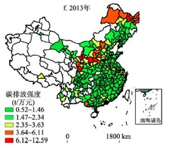
Since the Paris Climate Change Conference in 2015, reducing carbon emission and lowering carbon intensity has become a global consensus to deal with climate change. Due to different economic development stages, carbon intensity is regarded as a better index to measure regional energy-related carbon emissions. Although previous scholars have made great efforts to explore the spatiotemporal patterns and key driving factors of carbon intensity in China, the results lack the perspective from city level because of limited availability of statistical data of city-level carbon emission. In this study, based on carbon intensity of 283 cities in China from 1992-2013, we used the kernel density estimation, spatial autocorrelation, spatial Markov-chain and quantile regression panel model to empirically reveal its spatial spillover effects and explore the critical impact factors of carbon intensity at the city level. Our result indicates that although the total carbon emission increased during the study period, carbon intensity saw a gradual decline and regional differences were shrinking. Secondly, the city-level carbon intensity presented a strong spatial spillover effect and diverse regional backgrounds exerted heterogeneous effects on regions. Thirdly, quantile panel data analysis result showed that for low-intensity cities, on the one hand, FDI and transport sector were main contributing factors, and economic growth, technical progress and high population density negatively affected carbon intensity. On the other hand, industrial activity, extensive growth of investment and urban sprawl were key promoting factors for high-intensity cities, and population density was beneficial to emission reduction task. Furthermore, technological advance has not exerted negative influence on carbon intensity in high-intensity cities. At last, we suggested that Chinese government should take different carbon intensity levels into full consideration before policy making.
Difficulties in corporate financing and high financing costs are the major problems that have constrained Chinese real economy, especially the development of non-state-owned economy in recent years. The geographical distance between industrial enterprises and branches of commercial banks is one of the factors that cause high financing costs. Due to cultural differences, transportation costs, information asymmetry, the geographical distance between industrial enterprises and branches of commercial banks will increase the financing costs of industrial enterprises. At the same time, an increase in the number of branches of commercial banks within a certain geographic radius will reduce the financing costs of enterprises. Based on technologies of data mining including Geocoding API in Baidu map, we calculate the geographical distance between industrial enterprises and branches of commercial banks in the Beijing-Tianjin-Hebei region. This paper quantitatively analyzes the correlation among financing costs of enterprises, the distance between enterprises and branches of commercial banks, and the number of branches of commercial banks in a radius of 1-5 km. Then we explain the mechanism of how the geographic distances will affect the financing costs of enterprises. The results show that: (1) within the 1-5 km radius, the closer the industrial enterprises are to the commercial banks (or the more branches of commercial banks), the lower the financing costs. (2) The geographic distance has a significant impact on both state-owned and non-state-owned industrial enterprises. Between them, non-state-owned enterprises have a higher level of significance. The number of branches of commercial banks within 1-5 km radius shows the same tendency. (3) The financing cost of industrial enterprises located in Beijing and Tianjin does not show statistical correlations to the distance between industrial enterprises and branches of commercial banks, and but it is negatively related to the number of branches of commercial banks within certain radius. The financing cost of industrial enterprises located in Hebei are positively correlated with the distance between industrial enterprises and branches of commercial banks, and it is negatively correlated with the number of branches of commercial banks. (4) The distance to branches of commercial banks affects heavy industry and labor-intensive industry more significantly. The number of branches of commercial banks within a radius of 1-5 km has little impact on different industries.
Accurately and effectively estimating the effects of urban pattern on industrial location is always an important issue that has received much attention in urban geography. However, current studies have mainly focused on the influence of a single type of urban functional spaces on industrial location using statistical data based on administrative units. And these studies have not conducted in-depth research into the spatial heterogeneity of influences. Against the existing shortcomings, taking the central Chongqing as an example, this research aimed to investigate how different urban functional spaces influenced the catering industry distribution based on kernal density, spatial autocorrelation and geographic weighted regression from point of interest (POI) data. The research reveals the following points: (1) the spatial distribution of restaurants was characterized by a multi-center spatial structure of "one main, two subs and four third-level centers", which directly reflected the urban pattern. (2) Not only the scale of restaurant agglomeration was closely related to urban expansion sequence, but also the direction of restaurant agglomeration was consistent with urban expansion direction. (3) The urban functional spaces had different or even opposite influences on the restaurant distribution in different city groups. The effect of residential space on the restaurant distribution was all positive, which increased from the central to the peripheral groups. The influence of commercial space on restaurant distribution was weakened from the inside to the outside of the barrier of the mountains, but there might be a phenomenon of commercial dependence in the groups where the location was isolated and the business development was immature. Since the restaurants in the peripheral groups was more dependent on the transport accessibility, the effect of urban traffic space on restaurant distribution in the peripheral groups was greater than that in the central groups, which resulted in a phenomenon of traffic dependence. The urban public space in central groups played a greater role in promoting restaurant assembled than that of the peripheral groups on account of high-quality public service in central groups. The influence of urban leisure space on restaurant distribution was related to the number and popularity of scenic spots. (4) Moreover, different urban functional spaces had different influences on the spatial distribution of restaurants, and urban commercial space had the greatest impact due to its high density of urban construction and population density. This study is especially valuable for understanding the function mechanism of urban pattern on industrial location and providing a scientific basis for making rational urban development plan.
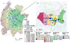
In present-day China, the unequal distribution of public healthcare resources across different levels and regions is problematic. Hierarchical diagnosis and treatment (HDT) reform is of great significance for optimising the distribution of healthcare resources and promoting fairness across health services. In this study, exploratory spatial data analysis (ESDA) was applied to evaluate spatial patterns at the lower and upper levels of healthcare resources. The Geodetector model was used to analyse the influences of the healthcare system at the municipal and county levels during 2015. The results show that there is significant spatial clustering in the distribution of the two-level healthcare resources. Influences on upper-level healthcare resources are more significant than those on lower levels. The dominant influencing factors of the two-level healthcare resources differ across spatial scales and regions. In terms of upper-level healthcare resources, urbanisation, population density and the level of economic development are the dominant global factors, in addition to the regional factors of population aging, topography and the morbidity of epidemic and endemic diseases. In the case of lower-level healthcare resources, urbanisation is an important influencing factor, while economic development, population aging and morbidity have local effects. Ultimately, population density was the dominant factor. Finally, this paper suggests that, aiming for HDT reform, decision makers should allocate healthcare resources among different regions and levels in consideration of relevant global and local factors, united and targeted policies, and top-down and bottom-up decision-making mechanisms. This could promote the overall function of the healthcare system and enhance the equity and coordination of multi-level healthcare resources.

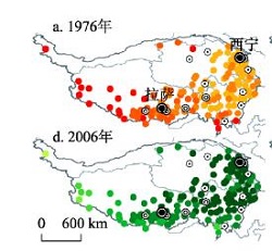
The Qinghai-Tibet Plateau is a unique geography-ecology-population-traffic region on the earth. The characteristics and regularities of the transport network development are an important breakthrough for the coordinated development of man-land relationship, which is of great significance to the research in the Qinghai-Tibet Plateau. Accordingly, this paper analyzes the evolution of transport network in this region between 1976 and 2016, and explores its accessibility using a temporal distance calculation model based on network analysis by taking provincial capitals, prefecture-level cities and counties as transport nodes. Results suggest that, first, transport network is more complex and the regional connectivity is gradually enhanced in the plateau, preliminarily forming a grid-like transport network; second, the average minimum accessibility time between anchor cities and between counties has been vastly reduced to 11.89 hours and 18.84 hours, manifesting a gradually growing spatial pattern from east to west and remarkable effects of time-space convergence; third, anchor cities are the poles of regional development, with average accessibility time to around cities reduced to 16.49 hours, indicating that anchor cities tied with others have been improved; fourth, the traffic circles of anchor cities and counties are evolving consistently, accessibility time from various places in the study area to their nearest cities or counties are decreasing, presenting a contiguous pattern of short-time traffic circle with 4-hour access to central cities and 2-hour access to counties along important arterial roads, thus improving external transport connection of towns. And traffic corridors are gradually formed in the Huangshui River Valley, and the Middle Region of "One River and Two Streams" in Tibet.
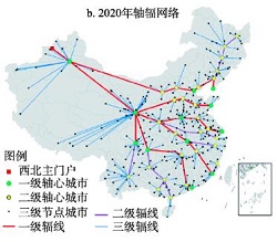
"The Belt and Road Initiative" has activated the westward economic and trade route, and the state has entered a new integrated development stage of land and sea. Previous studies mainly focused on ocean-oriented urban circulation network, however the research on the inland-oriented area needs to be expanded in both content and methods. Using spatial analysis, the paper constructed a framework of "circulation cost-accessibility and the ratio of export-oriented trade-market competition and policy protection-circulation structure and organizational models", and conducted research on the structural features of westward circulation network and organizational models of the circulation of goods based on the west corridor. The research finds that the high grade circulation node shows the overall approximation on the path of the minimum time and the cost of the freight, and the production capacity of flow node shows significant difference under the market competition, the coastal areas nodes, especially the Yangtze River Delta and Pearl River Delta, have significant scale advantages of current flows, but inland nodes with local subsidy policies could radiate the coastal area and launched supply competition. Wuhan, Xi'an, Zhengzhou, Chongqing and Changsha are the best inland nodes of coastal source. According to the characteristics of westward circulation network in the aspects of nodes, lines and flow, the "delta structure" of the country's westward circulation can be extracted. Based on the key nodes of westward circulation network, the paper proposed four patterns: the unified marshalling pattern, key node cities model, "export cities" model and key port cities model. The westward circulation has experienced the initial stage, diffusion stage and dispersed stage, and will enter the integration stage. The leading power of westward circulation will eventually return to the cities located in the advantageous space.
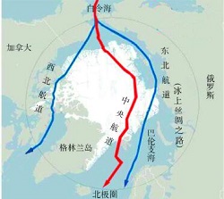
Under the macroscopical background of "Polar Silk Route", the paper puts forward the land and river intermodal transport route from Dalian to Tiksi Port of the Arctic Ocean (hereinafter referred as land and river intermodal transport route). The land and river intermodal transport route is a line available, which vertically connects the two economic belts between the northeast of China and the Siberia of Russia. Through the comprehensive analysis of the latest researches upon river and land intermodal transport route, which are carried out by Heilongjiang University, Melnikov Permafrost Institute of Russian Academy of Sciences and North-Eastern Federal University. Among them, the river transport section is the waterway from Russian Yakutsk City to Lena River of Tiksi Port; the land transport section runs through China and Russia and the central part of Northeast Asia, mainly including the railway and highway transport from Dalian to Yakutsk. And the main cities along the river and land intermodal transport route contain: China Dalian-Harbin-Heihe-Russian Blagoveshchensk (Hailanpao)-Neryungri-Yakutsk-Tiksi Port. Every node of land transport section has mature transportation systems, transit nodes with complete facilities and great economic development prospects. From July to September, Lena River has at least 3 months suitable for shipment and allows ship navigation with a weight of over 3000 tons. In summer, the Sino-Russia Northeast Asia land and river intermodal transport route has advantages of both short transportation distance and time. Along the route, there are abundant mineral resources. When the economy along the route gets improved, the trades between Asia and Europe can be connected and enhanced.
Villages in mountainous areas are under the risk of topography, geomorphology and frequent natural disasters in a long term. Rural transportation system is characterized by low network degree and weak capacity to resist disasters, and the problem of vulnerability of traffic environment is prominent. Taking Luonan county in the Qinling-Daba mountainous areas as an example and based on exposure, sensitivity and response capacity of human-environment system vulnerability, this paper constructed a basic framework of rural transportation environment vulnerability, which contained the key elements of risk events, geographical features, key travel path, road network structures, public and private vehicles, family capital etc., and established a targeted evaluation index system. With the aid of ArcGIS and GeoDa, this research examined the spatial structure and spatial autocorrelation of the transportation environment vulnerability in Luonan county at the village level. It also utilized a geographical weighted regression model to explore the factors of natural conditions, population, socio-economic development, which had influence on response capacity of traffic risk and its spatial difference. The results showed that the vulnerability of transportation environment took the county seat and the suburbs as the center increasing outward, which presents a circle structure featured by great difference in vertical direction. Simultaneously, the vulnerability of the transportation environment in village-level residential areas showed a significant positive spatial autocorrelation, but both exposure degree and sensitivity showed a significant spatial negative correlation with the response capacity. There were three patterns of local spatial correlation in transportation environment vulnerability: the vulnerability of the local "hot spots" areas was widely observed in the north- central mountainous area and fell into the dilemma of high exposure, high sensitivity and low response capacity, while the "cold spots" villages were founded in suburbs or areas adjacent to the towns with higher income, which had low sensitivity and high response capacity. There were a few "heterogeneity points", and these villages were adjacent to low-vulnerable villages, but they belonged to high-vulnerable areas. Moreover, topographical condition, industrial distribution, population structure, education level and family size had a significant impact on response capacity of transportation risk. In addition, the effect direction and intensity of the influencing factors had significant spatial differences.
Along with the unprecedented breadth and intensity of migrating activities motivated by the increasing mobility, family (as one of the most significant and nearly the smallest geographical unit) migration has become the most important pattern of migration in China, and in so doing the migration studies related to family has also been identified as an unreplaceable topic in mobility studies. Accompanied with this wave of family migration, in particular in the context of China's new urbanization, an increasing number of scholarships have intensively focused on the topics themed on migrated family's spatial practices and their emotional belongings. In the process of migrated family's mobilities, the meaning of the space "home" has been being continuously contested by the practices of mobilized families. By using the theoretical perspective of mobility, as well as the research line of the geography of home, this paper adopts the methods of qualitative and comparative case study (based on two typical cases of migrated families) to discuss the impact of migration on the mobilizing families' spatial practices and emotional reconstruction. The main finding indicates that the temporality, spatiality and placeness are several very important variables and dimensions of the study of mobility. As a fundamental ruler for characterizing the mobility, the multi-displacement spatiality of the flowing trajectory and the multi-stage temporality of the flowing process make the locality of the home being in a status of dynamic correlation. In this regard, the emotional belonging of home and the concept and the meaning of home are prolonged and reconstructed in the process of family migrations and related family-making practices. This empirical article provides a vivid description of local practices for the geography of "home" in China, and hopefully it can be contributed to promoting the theoretical progress of geography of home.

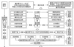
"Ruralism-ecology" space of urban agglomeration (RESUA) is an important part of land space and an organic part of urban agglomeration space. It is also a strategic space for urban agglomeration to optimize the spatial structure of urban and rural areas, maintain traditional human activities, inherit regional history and culture and maintain a healthy ecosystem. It is of great significance to focus on the process, pattern and mechanism of RESUA constructed by tourism so as to meet the national strategic needs and the disciplinary construction of tourism geography. This paper systematically sorts out the relevant literatures on urban agglomeration space, tourism development impact and essential attribute of RESUA. We find that there are some deficiencies in existing research. First, the existing research focuses less attention on the marginal zone in and around urban agglomeration. Therefore, it is necessary to explore and define the new functional geographical space. Second, the existing research focuses less attention on the fact that tourism significantly affects China's economic and social space as well. Thus, it is requisite to reinforce the typical spatiality study of China's modern economic system construction, ecological civilization construction and excellent traditional cultural inheritance and innovation promoted by tourism. Third, the existing research focuses less attention on the utilization method of RESUA. So it is essential to enhance research on urban-rural space utilization and urban-rural relationship evolution. This paper suggests that tourism, as a new industrial path and new utilization method, scientifically guides the implementation of the main function-oriented zoning, and promotes the transformation and upgrading of RESUA. Therefore, exerting the influence of tourism in the spatial structure optimization of urban agglomeration and the sustainable development of urban agglomeration is a major measure to explore the path with Chinese characteristics of national land renovation and space optimization. On the basis of establishing the "three-stage" theory hypothesis of RESUA constructed by tourism, the future research can be conducted in the following aspects. First, it is required for researchers to follow the research route of "process-pattern-mechanism-effect" and explore the practical path of RESUA constructed by tourism. Second, researchers should propose a technological path to study the policy security system of RESUA constructed by tourism. Third, the general characteristics and laws of RESUA constructed by tourism should be explored in different scales.