吴欣昕 , 刘小平, 梁迅, 陈广亮
中山大学地理科学与规划学院,广州 510275
WU Xinxin, LIU Xiaoping, LIANG Xun, CHEN Guangliang
通讯作者:
收稿日期: 2018-01-16
修回日期: 2018-02-18
网络出版日期: 2018-04-20
版权声明: 2018 《地球信息科学学报》编辑部 《地球信息科学学报》编辑部 所有
基金资助:
作者简介:
作者简介:吴欣昕(1994-),女,硕士生,研究方向为大数据与城市模拟。E-mail: wuxx33@mail2.sysu.edu.cn
展开
摘要
城市增长边界(UGBs)能够控制城市空间的无序蔓延并引导城市合理增长,多发展情景下的UGBs是对不同规划条件下城市未来发展空间范围进行界定的常用方法。元胞自动机(CA)模型能对未来城市发展进行动态的预测,并已广泛的应用于UGBs的划定中。然而,目前的方法和模型大多只针对单一的城市发展情景进行UGBs的划定,较少能对未来多种发展情景下的UGBs进行准确划定。因此,针对这个问题本文提出了一种基于未来用地模拟(FLUS)模型和膨胀与腐蚀的算法的多情景UGBs划定模型(FLUS-UGB)。本文选取珠江三角洲地区为研究区,在对2000-2013年珠江三角洲地区城市土地利用进行模拟和验证的基础上(Kappa系数为0.715,总体精度为94.539%),预测了2013-2050年基准、耕地保护及生态控制3种情景下珠江三角洲地区的城市扩张,并根据预测结果对该地区UGBs进行划定。结果显示,该方法能够针对不同的城市发展情景进行相应UGBs的划定,具有较好的可靠性及适用性。
关键词:
Abstract
Arising from rapid growth of economy and population,urban sprawl has become a major challenge for sustainable urban development in the world. In order to assist urban planning, applicable methods and models are required to guide and constrain the growth of urban areas. Nowadays, urban growth boundaries (UGBs) has been regarded as a common tool used by planners to control the scale of urban development and protect rural areas which has a significant contribution to local ecological environment. However, existing models mainly focus on the delimitation of UGBs for urban development in single-scenarios. To date, there are rarely studies to develop efficient and scientific methods for delimiting the UGBs by taking the influences of macro policy and spatial policy into account. This paper presents a future land use simulation and urban growth boundary model (FLUS-UGB) which aims to delimit the UGBs for the urban areas in multi-scenarios. The top-down system dynamics (SD) model and bottom-up cellular automaton (CA) model are integrated in FLUS sub-model for simulating the urban growth pattern in the future. Furthermore, the UGB sub-model is developed to generate the UGBs that uses a morphological technology based on erosion and dilation according to the urban form produced by FLUS. This method merges and connects the cluster of urban blocks into one integral area and eliminates the small and isolated urban patches at the same time. We selected the Pearl River Delta region (PRD), one of the most developed areas in China, as the case study area and simulate the urban growth of PRD region from 2000 to 2013 for validate the proposed model. Then we used FLUS-UGB model to delimit the UGBs in PRD region of 2050 under three different planning scenarios (baseline, farmland protection and ecological control). The results showed that: (1) the model has high simulation accuracy for urban land with Kappa of 0.715, overall accuracy of 94.539% and Fom 0.269. (2) the method can maintain the edge details well in areas with high urban fragmentation and fractal dimension. This research demonstrates that the FLUS-UGB model is appropriate to delineate UGB under different planning policies, which is very useful for rapid urban growth regions.
Keywords:
在中国快速城市化进程中,城市建设用地不断快速增长,产生了城市无序蔓延、侵占优质耕地、自然资源过度开发等严重问题[1]。这些问题将会造成严重的生态恶化与耕地流失,从而对城市的可持续发展形成了巨大的挑战[2]。因此,如何科学地引导城市的发展,协调城市建设用地保障与生态环境、耕地保护间的平衡关系已经成为当前城市管理与规划中急需解决的问题[3]。目前控制城市发展的政策普遍都致力于增加城市用地的使用密度与保护优质的开放空间[4],主要包括绿带(Greenbelt)、城市增长边界(Urban Growth Boundary, UGB)和城市服务边界(Urban Service Boundary, USB)3种方式[5]。其中,城市增长边界的功能是用于界定城市与非城市区域,它通过用地区划、开发许可证等调控手段,将城市开发规模控制在边界以内,从而控制城市用地的增长规模[6],已被广泛应用[7,8,9,10]。
随着UGBs的广泛应用,有效且科学的UGBs划定方法成为当前的研究热点,国内一些学者运用多种模型和方法对UGBs的划定进行了探索[11,12]。传统的人工划定城市增长边界所采用方法往往难以反映城市用地内部的发展规律,并缺乏充分的科学依据与定量分析,包含主观因素,从而难以合理有效地调控城市用地发展[6]。此外,有学者采用城市发展适宜性评价模型同时结合一系列相关空间因素用于UGBs的划定[13]。这种方法虽然简便,但难以反映相关地理因素的相互作用机制,并忽略了城市发展的历史规律且不具备预测城市未来发展的多种情景的能力[7]。
元胞自动机(Cellular Automata, CA)是一种“自底向上”的地理模拟模型,能够动态地反映出城市系统的复杂结构,因而被广泛应用于土地利用的模拟与预测中[14,15,16,17]。目前有许多研究将CA模型的城市发展模拟的结果加入UGBs的划定中以弥补传统方法的缺陷。例如,Tayyebi等[18]设计了基于2种规则的CA模型,将其应用于德黑兰大都会区域并直接依照城市发展模拟结果进行UGBs的划定; 李咏华[19]构建了生态视角下的GIA-CA空间模型,将生态保护的传统被动防御转变为主动控制的模式,并通过杭州的实证研究得出该模型能够有效进行UGBs的划定。此外,CA模型通过结合相关智能算法如人工神经网络[20],随机森林[21],蚁群算法[22]等确定模型的元胞转换规则,这些智能算法用以优化CA模型应用于城市发展模拟与预测,提高以CA模拟结果进行UGBs划定的真实性与可靠度。
然而,在复杂多变的城市发展进程下,基于CA模型的UGBs划定也存在一定的问题。许多基于CA的UGBs模型仅根据CA模型的城市模拟结果,而忽略了“自顶向下”的城市区域规模的控制以及政府规划政策的影响,即缺乏考虑宏观土地供需以及空间政策调控等复杂驱动因素的影响[7,23]。当前大部分利用CA进行UGBs的划定的研究是针对单一的城市发展场景构建,但城市在不同规划条件下将呈现发展情景的差异,目前较少有对城市未来发展多种情景下的UGBs划定。同时,受到复杂地形与较快的城市发展速度的影响,中国的许多区域的城市形态往往呈现出较高的离散度和破碎度,而目前大多的UGBs划定均较为粗糙和模糊,难以根据实际情况进行及时和灵活的调整[24]。
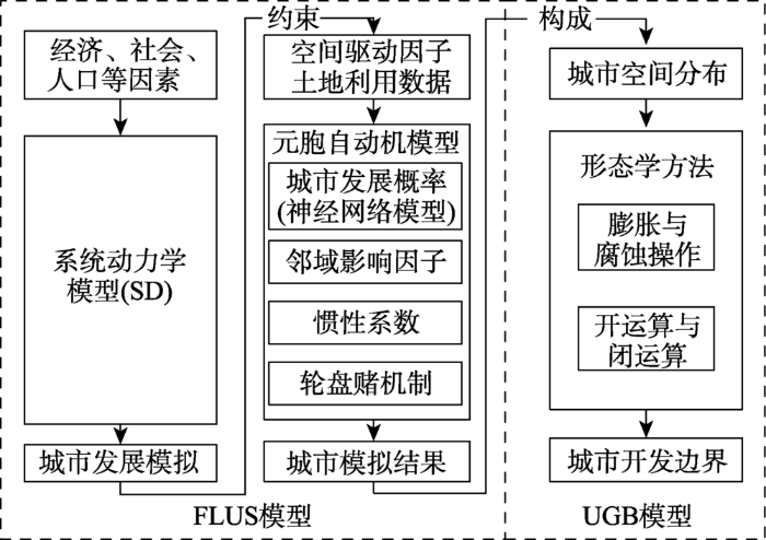
结合上述背景及问题,本文引入未来用地模拟FLUS模型与基于形态学膨胀与腐蚀方法的边界提取UGB模型,将二者结合构建成FLUS-UGB模型,用于多情景下城市发展形态的高效UGBs划定。其中,FLUS模型被证明能够有效地进行多情景下的复杂土地利用变化模拟[25],而形态学的膨胀与腐蚀方法能够有效进行边缘提取与图像的分割与细 化[26]。本文尝试将FLUS-UGB模型进行精度验证后,将膨胀腐蚀方法应用于广东省珠江三角洲区域2050年多种情景下的城市用地发展模拟与UGBs划定中,为UGBs的划定提供方法上的参考。
未来用地模拟FLUS模型已被实证能够有效地应用于多情景下的全球尺度及多类的土地利用模拟中,并较传统模型有更高的模拟准确度[25,27],本文则采用该模型进行未来城市发展模拟。FLUS模型的框架包括2个部分:① 根据宏观的社会经济、人口发展与社会政策等条件,利用系统动力学SD进行建模,用以预测未来城市用地的开发规模;② 结合CA模型,考虑相关交通、规划与自然条件等一系列影响城市发展的因素,将元胞向城市用地转换的可能性、元胞间的相互作用和城市总体发展趋向三者进行结合,共同参与元胞转换总体概率的计算。最终利用轮盘赌机制以确定元胞是否发生用地类型的转换,从而实现城市用地发展的动态模拟。在实现边界提取的UGB模型中则通过形态学中的膨胀与腐蚀操作,二者构成开运算与闭运算,利用定义的结构元素对FLUS模拟得到的城市用地模拟结果进行遍历从而进行UGBs的划定,FLUS-UGB的总体模型结构如图1所示。
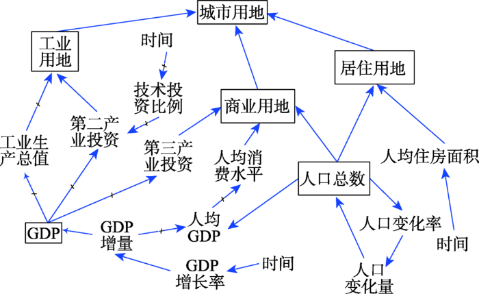
系统动力学(System Dynamics, SD)模型是建立在控制论、系统论和信息论基础上研究反馈系统结构、功能和动态行为的一类模型,其通过不同模块和变量之间的交流与回馈从而模拟复杂系统的行为[28,29]。SD模型具有“自顶向下”的特点,能够科学地预测出不同规划政策与发展条件下的未来城市用地变化,相关研究表明SD模型能够从宏观上反映土地系统的复杂行为,是进行土地系统情景模拟的良好工具[30,31]。本文利用SD模型结合人口、经济、社会等多方面的因素用于多情景下未来城市增长的用地规模预测。在SD模型中,不同因素之间的反馈及相互作用则通过拟合的经验公式进行定义,其中构建内部经验公式的数据主要来源于研究区域近年的统计年鉴数据。本文通过Vensim软件(http://vensim.com/)构建的SD模型如图2所示,主要包括人口子系统、经济子系统和土地利用子系统3大模块,其中土地利用子系统将用地分为居住、工业和商业3大类型。
图2 系统动力学模型内部结构图
Fig. 2 The interactions between different factors in the system dynamics
本文设置模拟时间步长及输出间隔时间均为 1年,包括2个阶段:① 2000-2013年为模型模拟阶段,通过运用历史数据对SD模型进行参数设定、模型调整及模型检验;② 2013-2050年则为多情景预测阶段,主要通过不同的规划条件进行参数确定,从而进行不同情景下的用地规模预测。
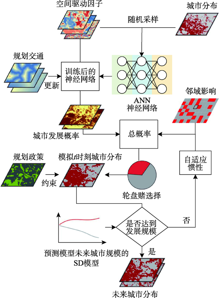
CA模型应用于城市用地的动态模拟中的核心内容是确定元胞的转换规则,FLUS模型对传统CA模型进行了改进,引入了人工神经网络(Artificial Neural Network, ANN)模型用以反映元胞转换为城市用地的可能性,同时利用惯性系数与竞争机制以表达动态模拟过程中城市与非城市用地的互动与竞争机制,这种改进的CA模型更能够适应城市空间的真实增长并反映出城市的长期发展态势。
在模拟过程中,首先利用神经网络模型通过自学习型的方式拟合出大量社会、经济、交通和自然等空间变量与城市土地利用的复杂对应关系,最终通过输出层计算出单元转换为城市用地的潜在可能性。ANN模型通过模仿人类大脑学习以进行智能计算,尤其适用于复杂非线性问题的求解,从而有效解决了多类空间变量复杂的权重分配问题[32]。在FLUS模型中采用三层BP神经网络模型,并根据研究所选取的空间变量设置神经网络中各层的神经元个数,而后通过选取的空间驱动因子与城市用地的历史分布的随机采样样本对ANN进行训练,通过ANN的计算从而得到元胞的发展概率。
将结合得到的元胞发展概率与元胞的邻域影响及自适应系数进行总体概率计算。其中,邻域影响反映了城市周围单元与中心单元的相互影响,表示邻域范围内各用地单元间的作用,本文选取了 3×3的Moore邻域模型进行城市模拟,可将元胞邻域影响因子的计算模型表达为式(1)。
式中:
综合上述元胞的发展概率、邻域影响因子和自适应惯性系数,可以确定各个元胞的土地利用总体转换概率(式(3))。
式中:
在得到元胞的总体转换概率后,许多相关研究的用地转换确定则通过优先分配对应总体概率最高的用地类型,即将土地利用类型转换成最高概率的类型[33,34],但这种方法仅考虑占主导的土地利用类型,忽略了其他非优势土地利用类型的分配机会。在FLUS模型中采用了轮盘竞争机制以确定城市单元是否发生土地利用类型的转换,其对城市模拟过程中土地利用的跨越式发展有重要意义[35]。轮盘竞争机制由轮盘所占面积代表分配概率,反映了具有较高总体概率则有更大的可能分配为某单元的用地类型,而有较低概率的用地类型仍有机会被分配,该机制的随机特征性使模型能够更好地反映用地模拟的动态性与不确定性。因而元胞单元将通过轮盘竞争机制分配到相应的用地类型,得到各个模拟时刻的城市发展形态。此时考虑城市的多情景发展情况,加入相关规划政策对结果进行约束,并根据SD模型预测的未来城市发展规模对模拟的迭代过程进行控制,以此实现SD模型与CA模型的耦合,最终得到模拟的未来城市发展形态。FLUS的城市用地模拟流程如图3所示。
形态学的处理过程是在研究区域中移动一个结构元素,将结构元素与区域进行交、并等集合运算,其基本的形态运算是腐蚀和膨胀[26]。膨胀腐蚀是一种针对集合的处理过程,通常用到的还包括由膨胀腐蚀构成的开运算与闭运算,其能够有效地解决图像噪声、特征提取、边缘检测、纹理分析、形状识别等问题[36]。本文结合上述所得的城市发展形态,基于膨胀腐蚀的开闭运算方法以进行城市边界的划定。
2.3.1 膨胀腐蚀方法
膨胀腐蚀是形态学中的一种边界规整方法。膨胀操作是由结构元素确定的邻域块中选取图像值与结构元素值的和的最大值,即代表着结构元素的移动将其中的非城市单元转化为城市单元。设
腐蚀操作则与膨胀相反,是由结构元素确定的邻域块中选取图像值与结构元素值的和的最大值,即利用结构元素中心单元对城市土地利用图像进行遍历,若当前城市单元邻域块与结构元素不完全一致,则去除该城市单元(即转变为非城市单元)。同样设
2.3.2 城市边界划定
城市开发边界的划定一方面需要考虑城市发展过程中受到自然条件的制约,另一方面也需要考虑城市未来可能形成的空间结构[37]。本文构建的FLUS-UGB模型参照未来城市发展的多重情景,将开、闭运算作用在城市未来用地发展模拟结果中。其中,开运算的实质为首先进行一次腐蚀操作后进行膨胀操作,根据上述膨胀腐蚀的定义,其可被表达为式(6)。
而闭运算则首先进行膨胀操作而后进行腐蚀操作,即为式(7)。
开、闭运算是膨胀与腐蚀常用的操作集合,图像处理中常常利用形态学开闭运算得方法对区域进行边缘平滑和内部填充等[38]。当其运用在城市边界的划定中,开运算能够切断细长的城市单元而实现分离,并起到平滑城市单元块的作用;而闭运算能够填充城市单元的缺口与空洞,从而连通城市单元块。因此,通过开、闭运算能够实现依据未来城市模拟结果以实现边界的划定,并确保最终得到的城市开发边界在保持城市总体的发展形态下进行划定,同时不会偏离与规划的总体目标。本文的FLUS-UGB模型采用了大小为
图4 基于形态学膨胀腐蚀UGBs划定的流程图
Fig. 4 Flow diagram of the UGBs delineation based on morphological method of erosion and dilation
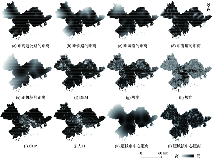
本文选取广东省珠江三角地区(Pearl River Delta, PRD)作为研究区域,珠江三角洲位于广东省南部,占地面积约为54 000 km2,包括广州、深圳、珠海、佛山、中山、江门、东莞、惠州与肇庆市[39]。在外部促进与内部整合的条件下,珠江三角洲地区的城市发展迅猛,而为了城市的可持续发展,合理规划城市发展边界以控制城市增长是十分必要的。同时,珠江三角洲区域的城市群分布多变,城市边界分布十分复杂,因此本文选取该地区城市开发边界划定的研究将更具有代表性。本文利用2000-2013年的珠江三角洲土地利用数据,城市土地利用类型主要考虑城市与非城市2类,研究所使用的数据均为30 m分辨率,图幅的尺寸为13 836像元×104 40像元,本文所使用的一系列自然、社会、经济等驱动力因素如图5所示。
图5 珠江三角洲区域土地利用模拟空间变量
Fig. 5 Spatial variables of land use simulation in PRD area
本文将FLUS模型应用中,根据上述选取的空间变量,能够确定神经网络模型的输入层中有13个神经元,输出层则对应城市与非城市2类。而后通过按0.1%采样比例对城市土地利用数据与空间驱动因子数据进行随机采样,获取研究区域的训练样本集,并应用于神经网络的训练中。将得到珠江三角洲城市的发展概率数据,结合上述元胞邻域影响、自适应惯性系数的共同作用,计算出元胞单元的总体发展概率。
本文以2000年珠江三角洲区域土地利用数据(图6(a))为初始状态,通过FLUS模型模拟得到2013年珠江三角洲区域的土地利用情况(图6(c)),对比2013年珠三角区域真实的土地利用情况(图 6(b)),可以看出利用FLUS模型进行城市土地利用模拟的结果与真实数据城市用地的分布大体一致。为了验证FLUS模型的模拟精度,引入Kappa系数与Fom系数进行模型精度评价。通过计算得到Kappa值为0.715,总体精度为94.539%,Fom值为0.269。结果表明,FLUS模型的模拟精度较高,即能够较好地呈现真实的城市发展形态,因而将其应用于预测城市未来用地发展的可靠性也较高。
图6 珠江三角洲2000-2013年城市用地动态模拟及实际情况对比
Fig. 6 Comparisons of actual and simulated land use in PRD region from 2000 to 2013
城市未来土地利用的模拟同时需要考虑不同的约束条件,进而能在模型预测中控制城市未来的发展趋势和城市扩张的强度与方向。本文在对城市未来发展的模拟中加入了相关规划约束条件,并规定模型在这些限制区域内,禁止非城市用地向城市用地的转变,使得模拟结果在规划约束的条件下发展。本文基于基准条件、耕地保护条件与生态控制条件建立了3种城市用地发展情景。
3.3.1 基准情景
在基准情景条件下,将不考虑人为的城市的规划控制、保护等因素,仅在原始自然条件下进行城市发展的模拟,此为无限制条件下城市发展的情景。因珠江三角洲地区目前没有制定长期的城市总体规划,而基准情景能够提供在没有政策干预前提下未来城市的无约束发展形态,从而能够为政府做出相关城市发展约束政策提供了参考。利用SD模型预测该情景下的2050年城市用地规模为 11 540.09
图7 基准情景珠江三角洲2050城市用地发展预测
Fig. 7 Prediction of urban land use in 2050 at PRD region in baseline scenario
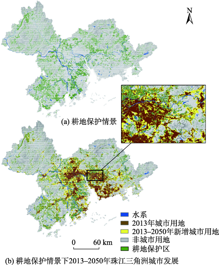
3.3.2 耕地保护情景
当前耕地数量与质量的维护对农业可持续发展至关重要,因而耕地保护情境下则基于基准条件下考虑城市的耕地保护政策与规划等。耕地保护情景将严格控制耕地转为非耕地,即在耕地区域禁止城市的发展,以防止城市化进程中耕作用地被侵占,从而控制耕地的快速流失,并为政府在优先保护耕地前提下进行未来城市发展规划提供了参照。在耕地保护情景下(图8(a)),利用SD模型预测珠江三角洲区域在2050年城市用地规模为11 498.83
图8 耕地保护情景及珠江三角洲2050城市用地发展预测
Fig. 8 Prediction of urban land use in 2050 at PRD region in farmland protection scenario
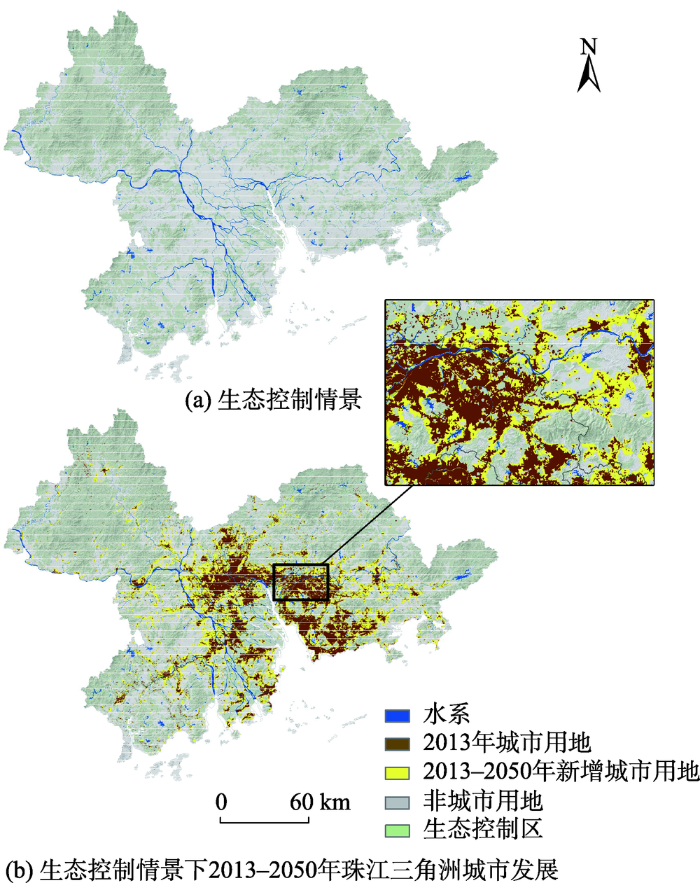
3.3.3 生态控制情景
生态控制情景与耕地保护情景类似,其基于基准条件下考虑生态控制区的保护。生态控制区能够在尊重城市自然生态系统和合理环境承载力的前提下,维护生态系统的科学性、完整性和连续性,防止城市无序蔓延。因而在生态控制情景下,将禁止生态控制区内发展为城市,该情景能够协调城市发展与生态格局间的共同发展,从而提升生态质量并实现城市的可持续发展。在生态控制情景下(图9(a)),利用SD模型预测珠江三角洲区域在2050年城市用地规模为11 509.42
图9 生态控制情景及珠江三角洲2050城市用地发展预测
Fig. 9 Prediction of urban land use in 2050 at PRD region in ecological control scenario
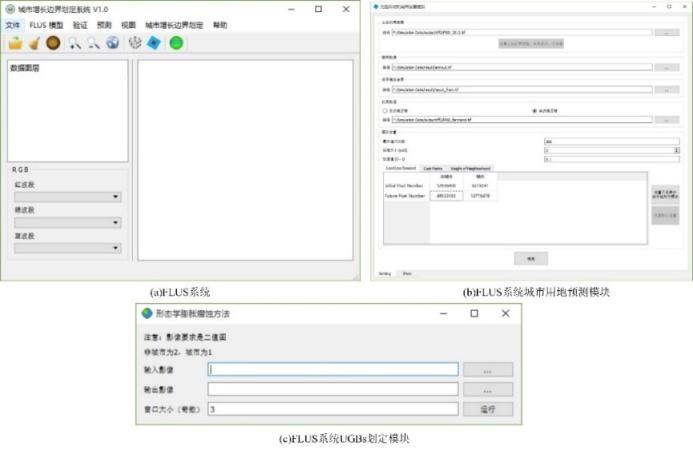
UGBs是依据城市未来用地发展形态进行划定,本文以FLUS模型预测得到的珠江三角洲城市未来用地发展为基础,利用了上述形态学基于膨胀腐蚀的开闭运算方法,并采用C++编程实现UGBs划定,并将其耦合成为FLUS系统(http://www.geosimulation.cn/flus.html)中的子模块,FLUS的系统及其功能模块如图10所示。
图10 FLUS系统中城市用地模拟及UGBs划定
Fig. 10 Urban land use simulation and UGBs delimitation in FLUS system
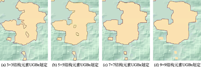
采用4种不同大小的结构元素进行UGBs划定的实验对比,结果如图11所示。本文分别采用大小为3×3、5×5、7×7和9×9的结构元素进行划定,结果显示采用7×7的结构元素进行UGBs的划定能够使边界整体平滑且连续性较强,边界线能较好地贴合城市区域轮廓,同时能够保持珠江三角洲地区城市复杂的边缘形状特征。
图11 4种结构元素大小的UGBs划定局部图
Fig. 11 The UGBs from four structural elements in details
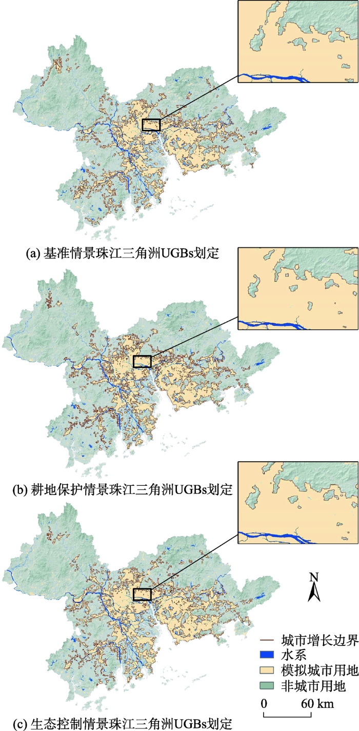
根据上述结果,即采用7×7的结构元素对珠江三角洲地区进行UGBs的划定,图12分别为在基准情景下(图12(a))、耕地保护情景下(图12(b))和生态控制情景下(图12(c))的UGBs划定结果。从图示中显示该方法在复杂的城市区域也能较好地保持边界的边缘细节,在城市破碎度与分维度较高的区域也能够提取出边界的形态特征。其通过形态学的膨胀腐蚀方法从而删除小而分散的紧凑性较差的城市单元,因而有效地增强了城市连片区域的集中性与整体性。
图12 3种情景下珠江三角洲2050年UGBs划定图
Fig. 12 The UGBs of PRD region under three planning scenarios in 2050
城市增长边界在促进城市可持续发展、保护城市外部空间和生态自然环境等方面有重要作用,而科学的UGBs划定方法是当前研究的热点问题[2,3]。本文构建了FLUS-UGB模型,其框架包括基于“自顶向下”的系统动力学模型与“自底向上”的元胞自动机模型耦合的未来城市用地模拟FLUS模型,以及基于形态学方法进行边界划定的UGB模型,从而用于多情景下未来城市发展的动态模拟及科学且高效地实现UGBs的划定以作为城市未来发展规划的参考。
本研究同时将模型应用于广东省珠江三角洲区域,考虑多类空间驱动因子,采用了珠江三角洲地区2000-2013年的城市土地利用数据,通过验证得出FLUS模型具有较高的模拟精度,其中计算得到Kappa值为0.715,总体精度为94.539%,Fom值为0.269。而后基于FLUS模型进行未来城市用地发展模拟,并考虑了3种约束城市发展的条件:基准、耕地保护与生态控制情景,得到2050年珠江三角洲区域的城市发展结果。
针对于UGBs的划定,本文利用FLUS模拟得到2050年珠江三角洲区域的城市模拟结果作为输入,通过基于形态学膨胀腐蚀方法的开运算与闭运算从而实现UGBs划定。结果显示,基于FLUS-UGB模型的城市开发边界划定能够较好地保持复杂城市区域的边缘形状特征,并且综合考虑了城市发展所受到的相关自然、政策条件制约以及城市未来的空间结构,因而能够真实地表达城市发展形态及其边界的分布。FLUS-UGB模型相较于传统的UGBs划定方法剔除了主观因素的划定影响,同时其能有效降低UGBs划定的时间成本,以缩短UGBs制定的周期,从而促使快速城市化进程中复杂多变的城市UGBs能够及时得到修订与完善。
FLUS-UGB模型能够科学地进行多情景下城市未来用地发展模拟及UGBs的划定,并有效地解决复杂城市群的边界划定的问题。该方法可以为今后中国UGBs的制定提供技术参考,并将其应用于城市未来规划与管控中。然而,本文的研究仅考虑了3种城市约束情景条件,今后可对多重城市约束情景下的UGBs划定进行研究,同时可以考虑将该模型应用于多个城市区域,从而验证模型的普遍适用性。
The authors have declared that no competing interests exist.
| [11] |
基于基础设施综合服务水平导向的城市增长边界划定——以广州市为例 [J].https://doi.org/10.3969/j.issn.1672-0504.2017.05.007 URL [本文引用: 1] 摘要
快速城镇化导致城市空间扩张对自然生态空间侵蚀突出,城市增长边界的界定和管控面临严峻挑战.该文 利用GIS技术,划定了 2010年广州市基础设施较为完善的城市建成区;遵循空间开发导向,确定了非建设用地开 发性综合指数;根据规划期内城市人口增长规模确定的新增建设用地规模与非建设用地开发性综合指数,明确城 市最适宜开发建设用地规模和空间布局;将最适宜开发建设用地与基础设施较为完善的建成区归并,确定2 0 2 0年 广州市UGB,大致形成了流溪河以北的机场、花都区连片建设区,珠江以北、流溪河以南和帽峰山等自然山体以南 连片建设区,海珠区和番禺区北部连片建设区、南沙区连片建设区等多片集中建设区,总体呈现/ 中心城区+ 外围” 多个连片建设区的发展格局.研究方法对全国其他城市划定城市开发边界具有借鉴意义.
Urban growth boundary delimitation oriented by comprehensive service level of infrastructure: A case study of Guangzhou [J].https://doi.org/10.3969/j.issn.1672-0504.2017.05.007 URL [本文引用: 1] 摘要
快速城镇化导致城市空间扩张对自然生态空间侵蚀突出,城市增长边界的界定和管控面临严峻挑战.该文 利用GIS技术,划定了 2010年广州市基础设施较为完善的城市建成区;遵循空间开发导向,确定了非建设用地开 发性综合指数;根据规划期内城市人口增长规模确定的新增建设用地规模与非建设用地开发性综合指数,明确城 市最适宜开发建设用地规模和空间布局;将最适宜开发建设用地与基础设施较为完善的建成区归并,确定2 0 2 0年 广州市UGB,大致形成了流溪河以北的机场、花都区连片建设区,珠江以北、流溪河以南和帽峰山等自然山体以南 连片建设区,海珠区和番禺区北部连片建设区、南沙区连片建设区等多片集中建设区,总体呈现/ 中心城区+ 外围” 多个连片建设区的发展格局.研究方法对全国其他城市划定城市开发边界具有借鉴意义.
|
| [12] |
基于资源环境承载力的合肥市增长边界划定 [J].https://doi.org/10.11821/dlyj201312012 URL [本文引用: 1] 摘要
在快速城市化和主体功能区战略背景下,滨湖城市作为城湖共生体,具有湖泊生态系统和城市社会经济系统双重属性,既是中国新型城市化格局中最具活力和潜力的核心单元之一,又是湖泊生态环境问题集中激化的高度敏感区,保护与开发并重,发展与风险共存。以行政区划调整后将巢湖纳入内湖的新合肥市为例,借助GIS平台,运用单因子评价法和综合敏感性评价法构成城市生态适宜性评价的方法体系,以水域因子、坡度因子、湿地因子、覆被因子、灾害风险因子组建资源环境约束指标体系,将合肥市域划分为极高敏感区、高敏感区、中敏感区、低敏感区、非敏感区5种资源环境承载类型区;基于反规划理念,构建滨湖城市空间增长模型,并划定作为城市扩展生态底线的刚性和弹性空间增长边界。在此基础上,统筹考虑城市空间资源环境保障能力、人口与用地规模,结合城市总体规划方案,明确城市空间扩展方向,科学划定城市近期、中期和远期的增长边界。该方法在中国滨湖城市的空间增长规模与方向、湖泊生态系统安保与开发、城市用地调控与优化组合以及城市规划方案的合理性评价方面可提供科学决策依据。
Urban growth boundary delimitation of Hefei city based on the resources and environment carrying capability [J].https://doi.org/10.11821/dlyj201312012 URL [本文引用: 1] 摘要
在快速城市化和主体功能区战略背景下,滨湖城市作为城湖共生体,具有湖泊生态系统和城市社会经济系统双重属性,既是中国新型城市化格局中最具活力和潜力的核心单元之一,又是湖泊生态环境问题集中激化的高度敏感区,保护与开发并重,发展与风险共存。以行政区划调整后将巢湖纳入内湖的新合肥市为例,借助GIS平台,运用单因子评价法和综合敏感性评价法构成城市生态适宜性评价的方法体系,以水域因子、坡度因子、湿地因子、覆被因子、灾害风险因子组建资源环境约束指标体系,将合肥市域划分为极高敏感区、高敏感区、中敏感区、低敏感区、非敏感区5种资源环境承载类型区;基于反规划理念,构建滨湖城市空间增长模型,并划定作为城市扩展生态底线的刚性和弹性空间增长边界。在此基础上,统筹考虑城市空间资源环境保障能力、人口与用地规模,结合城市总体规划方案,明确城市空间扩展方向,科学划定城市近期、中期和远期的增长边界。该方法在中国滨湖城市的空间增长规模与方向、湖泊生态系统安保与开发、城市用地调控与优化组合以及城市规划方案的合理性评价方面可提供科学决策依据。
|
| [13] |
Modelling of urban growth boundary using geoinformatics [J].https://doi.org/10.1080/17538940902971383 URL [本文引用: 1] 摘要
Urban growth boundary (UGB) is a regulatory measure of local government for delineating limits of urban growth over a period of time. Land within the UGB allows urban development, while the land outside of this boundary remains primarily non-urban. The increasing popularity of UGB demands an easy and effective method to design this boundary. This article introduces a new concept, Ideal Urban Radial Proximity (IURP), to designate a spatial UGB using geoinformatics in the digital environment. The Kolkata urban agglomeration was considered to demonstrate this model. Remotely sensed imageries of three temporal instants (years 1975, 1990 and 2005) were considered to determine the information on urban extent and growth of the city. These data were then used as inputs to model the UGB for the years 2020 and 2035. The proposed model discourages scattered development and increase in urban growth rate. It preserves urban vegetation, water bodies and any other important non-urban areas within the inner city space. The IURP concept will also be useful to make the cities circular and polycentric urban blobs into a monocentric tract. Apart from the proposed model and derived results, this research also proves the potential of geoinformatics in modelling a UGB.
|
| [14] |
Loose-coupling a cellular automaton model and GIS: Long-term urban growth prediction for San Francisco and Washington/Baltimore [J].https://doi.org/10.1080/136588198241617 URL PMID: 12294536 [本文引用: 1] 摘要
Prior research developed a cellular automaton model, that was calibrated by using historical digital maps of urban areas and can be used to predict the future extent of an urban area. The model has now been applied to two rapidly growing, but remarkably different urban areas: the San Francisco Bay region in California and the Washington/Baltimore corridor in the Eastern United States. This paper presents the calibration and prediction results for both regions, reviews their data requirements, compares the differences in the initial configurations and control parameters for the model in the two settings, and discusses the role of GIS in the applications. The model has generated some long term predictions that appear useful for urban planning and are consistent with results from other models and observations of growth. Although the GIS was only loosely coupled with the model, the model''s provision of future urban patterns as data layers for GIS description and analysis is an important outcome of this type of calculation.
|
| [15] |
Modelling sustainable urban development by the integration of constrained cellular automata and GIS [J].https://doi.org/10.1080/136588100240886 URL [本文引用: 1] 摘要
Cellular Automata (CA) have attracted growing attention in urban simulation because their capability in spatial modelling is not fully developed in GIS. This paper discusses how cellular automata (CA) can be extended and integrated with GIS to help planners to search for better urban forms for sustainable development. The cellular automata model is built within a grid-GIS system to facilitate easy access to GIS databases for constructing the constraints. The essence of the model is that constraint space is used to regulate cellular space. Local, regional and global constraints play important roles in affecting modelling results. In addition, ''grey'' cells are defined to represent the degrees or percentages of urban land development during the iterations of modelling for more accurate results. The model can be easily controlled by the parameter k using a power transformation function for calculating the constraint scores. It can be used as a useful planning tool to test the effects of different urban development scenarios.
|
| [16] |
Calibration of stochastic cellular automata: The application to rural-urban land conversions [J].https://doi.org/10.1080/13658810210157769 URL [本文引用: 1] 摘要
Despite the recognition of cellular automata (CA) as a flexible and powerful tool for urban growth simulation, the calibration of CA had been largely heuristic until recent efforts to incorporate multi-criteria evaluation and artificial neural network into rule definition. This study developed a stochastic CA model, which derives its initial probability of simulation from observed sequential land use data. Furthermore, this initial probability is updated dynamically through local rules based on the strength of neighbourhood development. Consequentially the integration of global (static) and local (dynamic) factors produces more realistic simulation results. The procedure of calibrated CA can be applied in other contexts with minimum modification. In this study we applied the procedure to simulate rural-urban land conversions in the city of Guangzhou, China. Moreover, the study suggests the need to examine the result of CA through spatial, tabular and structural validation.
|
| [17] |
Cellular automata models for the simulation of real-world urban processes: A review and analysis [J].https://doi.org/10.1016/j.landurbplan.2010.03.001 URL [本文引用: 1] 摘要
In recent years, cellular automata (CA) models for urban growth simulation have proliferated because of their simplicity, flexibility and intuitiveness, and particularly because of their ability to incorporate the spatial and temporal dimensions of the processes. Though apparently simple, CA models are capable of modeling complex dynamic systems such as urban systems. Currently, one of the main problems in actually applying CA models to urban planning practice is the choice or design of the most suitable CA model. For this reason, a review of urban CA models applied to real-world cases is provided, along with an analysis of their capabilities and limitations. The review and classification of CA models based on the main characteristics of the models has allowed for the analysis of their strengths and weaknesses. Finally, a discussion of the needs for further research is presented.
|
| [18] |
Two rule-based urban growth boundary models applied to the Tehran Metropolitan Area, Iran [J].https://doi.org/10.1016/j.apgeog.2011.01.018 URL [本文引用: 1] 摘要
Urban Growth Boundaries (UGBs) that limit urban expansion out are being implemented by planning agencies worldwide. Thus, there is a need to create models that can simulate changes in urban boundaries. The aim of this paper is to present two rule-based spatial emporal models, one which employs a Distance Dependent Method (DDM) and the other a Distance Independent Method (DIM), to simulate UGBs. These rule-based Urban Growth Boundary Models (UGBMs) use azimuths and distances, vector-based predictive variables, directed from central points within the urban area, to simulate UGB change. DDM employs a single urban boundary in the initial time step to predict the urban boundary in any subsequent time according to the increment of distances across different azimuths. Similarly, the DIM uses the change in distance between two boundaries, one in the initial time step and one in subsequent time step, across different azimuths, to predict the future urban boundary. We use the two rule-based models, DDM and DIM, to project the urban boundary of the Tehran Metropolitan Area in 2012 using data from 1988 to 2000. We compare these rule-based simulation UGBMs to a null UGBM developed from the same data but lacking in specificity of predictive variables. Percent Area Match (PAM) quantity and location goodness of fit metrics are used to assess the agreement between simulated and observed urban boundaries. Results indicate that rule-based UGBMs have a better goodness of fit compared to a null UGBM using PAM quantity and location goodness of fit metrics. We discuss how UGBMs can be used to assist planners in developing future UGBs.
|
| [19] |
生态视角下的城市增长边界划定方法——以杭州市为例 [J].
以生境恶化和土地资源供需平衡两大现实问题为背景,针对当前城市增长边界划定方法存在的误区,在分析GIA与约束性CA模型的基础上,构建了生态视角下的GIA-CA空间模型。该模型将生态保护的传统被动防御转变为主动控制的模式,以城市存量土地"质"的生态分级和"量"的有限供给作为空间增长模拟的宏观约束条件,从而划定城市增长边界,达到控制城市蔓延和引导城市在适宜发展区域增长的目标。最后,杭州的实证研究证明,以GIA-CA模型划定城市增长边界能够破解当前城市蔓延相关问题,从而保障了健康城镇化的顺利进行。
Method of determining urban growth boundary from the view of ecology: A case study of Hangzhou [J].
以生境恶化和土地资源供需平衡两大现实问题为背景,针对当前城市增长边界划定方法存在的误区,在分析GIA与约束性CA模型的基础上,构建了生态视角下的GIA-CA空间模型。该模型将生态保护的传统被动防御转变为主动控制的模式,以城市存量土地"质"的生态分级和"量"的有限供给作为空间增长模拟的宏观约束条件,从而划定城市增长边界,达到控制城市蔓延和引导城市在适宜发展区域增长的目标。最后,杭州的实证研究证明,以GIA-CA模型划定城市增长边界能够破解当前城市蔓延相关问题,从而保障了健康城镇化的顺利进行。
|
| [20] |
Calibration of cellular automata by using neural networks for the simulation of complex urban systems [J]. |
| [21] |
基于随机森林CA的东莞市多类土地利用变化模拟 [J].https://doi.org/10.3969/j.issn.1672-0504.2016.05.005 URL [本文引用: 1] 摘要
城市土地利用及其变化对城市环境有着重要影响.很多学者已经结合元胞自动机和机器学习算法对城市扩张进行了相关的模拟研究,但针对复杂的多类土地利用相互变化过程的研究仍然较少.该文提出了一种基于随机森林算法的多类元胞自动机(RFA-CA)模型,并将其用于模拟和预测复杂的多类土地利用变化.该模型使用随机森林算法提取元胞自动机的转换规则,并计算了各空间变量的重要性,在东莞市2000-2014年土地利用动态模拟结果中,Kappa系数和整体精度分别为0.73和84.7%.针对每一种土地利用类型,计算了影响东莞市土地利用变化的各空间变量的重要性,结果显示,交通、区位因素对东莞市土地利用变化格局的形成有重要影响.文中引入的POIs邻近因素反映了城市空间开发程度的高低,同样对多类土地利用格局的形成具有重要作用.
|
| [1] |
Urbanization, urban land expansion and environmental change in China [J].https://doi.org/10.1007/s00477-013-0840-9 URL [本文引用: 1] 摘要
China’s economic reforms and unprecedented growth have generated many fascinating issues for scholarly research. An understanding of urbanization and land use change in China is required for appropriate strategies and policies to facilitate future sustainable development. This paper reviews the literature on urbanization, land use and sustainable development in China with a focus on land use change. We argue that land use and environmental research are embedded in the complex economic-geographical processes and multiple trajectories of development and urbanization in China. This paper highlights the important role of space–time modeling in a multi-disciplinary setting in the study of urbanization, land use and sustainable development. It also points out potential areas for future research.
|
| [2] |
城市建设用地增长研究进展与展望 [J].https://doi.org/10.11820/dlkxjz.2011.11.015 URL Magsci [本文引用: 2] 摘要
针对目前城市建设用地快速增长现象、耕地流失及城市建设用地保障不足的用地现实,本文对国内外城市建设用地增长研究的主要进展进行了分析总结,以期为深化中国城市建设用地增长研究、解决现实用地矛盾、正确引导城市建设用地发展、践行健康城市化之路提供参考。当前,国内外学者已在城市建设用地增长的时空过程与特征、影响因素与动力机制、模拟预测方面进行了多尺度、多地域的综合性与典型性研究,探讨了城市建设用地增长对耕地的占用,并提出了一些致力于城市用地增长调控的对策与方法。采用的定量分析方法主要包括数理统计法、RS/GIS 技术、灰色系统分析法、MAS/CA模型等。研究成果对于深入认识和调控城市建设用地增长起到了重要作用。基于中国基本国情及当前面临的土地利用问题,未来的建设用地变化研究应逐步向城市与乡村相结合领域转型,研究方法将由一维逐渐向二维、三维甚至多维拓展,并据此为国家制定和完善土地管控政策提供科学依据;此外,未来应强化城市土地集约利用和增长边界控制,以有效控制城市建设用地的低效、过速扩张,实现精明增长。
|
| [21] |
Simulating spatiotemporal chang of multiple land use types in Dongguan by using random forest based on cellular automata [J].https://doi.org/10.3969/j.issn.1672-0504.2016.05.005 URL [本文引用: 1] 摘要
城市土地利用及其变化对城市环境有着重要影响.很多学者已经结合元胞自动机和机器学习算法对城市扩张进行了相关的模拟研究,但针对复杂的多类土地利用相互变化过程的研究仍然较少.该文提出了一种基于随机森林算法的多类元胞自动机(RFA-CA)模型,并将其用于模拟和预测复杂的多类土地利用变化.该模型使用随机森林算法提取元胞自动机的转换规则,并计算了各空间变量的重要性,在东莞市2000-2014年土地利用动态模拟结果中,Kappa系数和整体精度分别为0.73和84.7%.针对每一种土地利用类型,计算了影响东莞市土地利用变化的各空间变量的重要性,结果显示,交通、区位因素对东莞市土地利用变化格局的形成有重要影响.文中引入的POIs邻近因素反映了城市空间开发程度的高低,同样对多类土地利用格局的形成具有重要作用.
|
| [22] |
利用蚁群智能挖掘地理元胞自动机的转换规则 [J]. |
| [2] |
Fang C L [J].https://doi.org/10.11820/dlkxjz.2011.11.015 URL Magsci [本文引用: 2] 摘要
针对目前城市建设用地快速增长现象、耕地流失及城市建设用地保障不足的用地现实,本文对国内外城市建设用地增长研究的主要进展进行了分析总结,以期为深化中国城市建设用地增长研究、解决现实用地矛盾、正确引导城市建设用地发展、践行健康城市化之路提供参考。当前,国内外学者已在城市建设用地增长的时空过程与特征、影响因素与动力机制、模拟预测方面进行了多尺度、多地域的综合性与典型性研究,探讨了城市建设用地增长对耕地的占用,并提出了一些致力于城市用地增长调控的对策与方法。采用的定量分析方法主要包括数理统计法、RS/GIS 技术、灰色系统分析法、MAS/CA模型等。研究成果对于深入认识和调控城市建设用地增长起到了重要作用。基于中国基本国情及当前面临的土地利用问题,未来的建设用地变化研究应逐步向城市与乡村相结合领域转型,研究方法将由一维逐渐向二维、三维甚至多维拓展,并据此为国家制定和完善土地管控政策提供科学依据;此外,未来应强化城市土地集约利用和增长边界控制,以有效控制城市建设用地的低效、过速扩张,实现精明增长。
|
| [3] |
Urban growth boundaries of the Beijing metropolitan area: Comparison of simulation and artwork [J].https://doi.org/10.1016/j.cities.2012.10.013 URL [本文引用: 2] 摘要
Urban growth boundaries (UGBs) have been extensively studied and applied in the USA as an effective tool to curb urban sprawl. The “People’s Republic of China Town and Country Planning Act” requires the establishment of urban construction boundaries (UCBs) in Chinese city master and detail plans. We consider planned UCBs in China to be Chinese UGBs, as they have similar implementation mechanisms to their counterparts in the USA. However, different from UGBs in the USA, Chinese UGBs often resemble “artwork” by urban designers. Accordingly, they lack sound analytical basis and fail to sufficiently accommodate market mechanisms of land use. When measured by the criterion that the UGB should result in a spatial pattern that corresponds to its map, the Chinese UGBs are not well implemented. In this paper, we propose a method to support establishing UGBs through constrained cellular automata (CA). Our approach takes into account influence factors related to urban growth and generates UGBs based on spatiotemporally dynamic simulations. This method is applied to establish UGBs for the central city, new cities and small towns in the Beijing Metropolitan Area. The results indicate that there are significant differences between the UGBs based on constrained CA simulations and those in the previously established city master plan. We argue that our method could be a helpful planning tool for the establishment of UGBs in Chinese cities.
|
| [22] |
Mining the conversion rules of geographical cellular automata by using ant colony intelligent [J]. |
| [23] |
多尺度联合驱动的城市增长模拟建模 [J]. |
| [4] |
Effectiveness of urban construction boundaries in Beijing: An assessment [J].https://doi.org/10.1631/jzus.A0920317 URL [本文引用: 1] 摘要
to consider contingencies, and the absence of a mechanism to monitor and adjust the UCBs to respond just in time to urban change.
|
| [5] |
Holding the line: Urban containment in the United States[R] . |
| [23] |
A multi-scale synergistic CA model for urban growth simulation [J]. |
| [24] |
容纳式城市发展政策:国际视野和经验 [J].[本文引用: 1] 摘要
<p><font face="宋体">容纳式城市发展政策是城市成长管理政策的重要内容,也是世界各国应对城市蔓延所普遍采用的一种政策.它主要包含绿带、城市增长边界和城市服务边界三种形式,三者对于城市发展的限制程度逐次递减,而实施的灵活性和复杂程度则逐次递增.容纳式城市发展政策的国际经验表明,明确、稳定的边界和综合性的配套措施是容纳式城市发展政策成功的关键性要素.而在我国现有的容纳式发展政策中,这些要素仍然较为缺乏,政策的实施效果也不够理想.因而,明确边界划定的方法和内容、厘清各类容纳式城市发展政策之间的关联,以及完善相关的税收和土地利用控制政策,是改进现有容纳式城市发展政策实施成效较为可行的方法.</font></p>
|
| [6] |
利用约束性CA制定城市增长边界 [J].Establishing urban growth boundaries using constrained CA [J]. |
| [24] |
Urban containment policy: A global experience [J].[本文引用: 1] 摘要
<p><font face="宋体">容纳式城市发展政策是城市成长管理政策的重要内容,也是世界各国应对城市蔓延所普遍采用的一种政策.它主要包含绿带、城市增长边界和城市服务边界三种形式,三者对于城市发展的限制程度逐次递减,而实施的灵活性和复杂程度则逐次递增.容纳式城市发展政策的国际经验表明,明确、稳定的边界和综合性的配套措施是容纳式城市发展政策成功的关键性要素.而在我国现有的容纳式发展政策中,这些要素仍然较为缺乏,政策的实施效果也不够理想.因而,明确边界划定的方法和内容、厘清各类容纳式城市发展政策之间的关联,以及完善相关的税收和土地利用控制政策,是改进现有容纳式城市发展政策实施成效较为可行的方法.</font></p>
|
| [25] |
A future land use simulation model (FLUS) for simulating multiple land use scenarios by coupling human and natural effects [J].https://doi.org/10.1016/j.landurbplan.2017.09.019 URL [本文引用: 3] 摘要
react-text: 364 Mega-urban agglomerations in China play a vital role in both national economic development strategies and national new-type urbanization. However, they suffer a series of environmental problems in …" /react-text react-text: 365 /react-text [more]
|
| [7] |
Delimiting the urban growth boundaries with a modified ant colony optimization model [J].https://doi.org/10.1016/j.compenvurbsys.2016.11.004 URL [本文引用: 3] 摘要
61Propose a method to delimit UGBs from the perspective of spatial optimization.61Incorporate urban processes and planning interventions into the ACO model.61Improved ACO model can retrieve optimal patterns for UGBs delimitation.61Spatial optimization-based method can derive plausible UGBs for smart growth.
|
| [8] |
Urban growth patterns and growth management boundaries in the Central Puget Sound, Washington, 1986-2007 [J].https://doi.org/10.1007/s11252-011-0213-4 URL [本文引用: 1] 摘要
Many regions of the globe are experiencing rapid urban growth, the location and intensity of which can have negative effects on ecological and social systems. In some locales, planners and policy makers have used urban growth boundaries to direct the location and intensity of development; however the empirical evidence for the efficacy of such policies is mixed. Monitoring the location of urban growth is an essential first step in understanding how the system has changed over time. In addition, if regulations purporting to direct urban growth to specific locales are present, it is important to evaluate if the desired pattern (or change in pattern) has been observed. In this paper, we document land cover and change across six dates (1986, 1991, 1995, 1999, 2002, and 2007) for six counties in the Central Puget Sound, Washington State, USA. We explore patterns of change by three different spatial partitions (the region, each county, 2000 U.S. Census Tracks), and with respect to urban growth boundaries implemented in the late 1990 as part of the state Growth Management Act. Urban land cover increased from 8 to 19% of the study area between 1986 and 2007, while lowland deciduous and mixed forests decreased from 21 to 13% and grass and agriculture decreased from 11 to 8%. Land in urban classes outside of the urban growth boundaries increased more rapidly (by area and percentage of new urban land cover) than land within the urban growth boundaries, suggesting that the intended effect of the Growth Management Act to direct growth to within the urban growth boundaries may not have been accomplished by 2007. Urban sprawl, as estimated by the area of land per capita, increased overall within the region, with the more rural counties within commuting distance to cities having the highest rate of increase observed. Land cover data is increasingly available and can be used to rapidly evaluate urban development patterns over large areas. Such data are important inputs for policy makers, urban planners, and modelers alike to manage and plan for future population, land use, and land cover changes.
|
| [26] |
数学形态学在图象处理中的应用进展 [J].The advances of mathematical morphology in image processing [J]. |
| [9] |
Predicting the expansion of an urban boundary using spatial logistic regression and hybrid raster-vector routines with remote sensing and GIS [J].https://doi.org/10.1080/13658816.2013.845892 URL [本文引用: 1] 摘要
This paper presents an urban growth boundary model (UGBM) which utilizes spatial logistic regression (SLR), remote sensing, and GIS to simulate the differentially expanding geometry of a dynamic urban boundary over decadal time periods. SLR is used as the core algorithm in a UGBM quantifying how biophysical factors influence the rate at which all edges of an urban boundary expand over time. Spatial drivers selected from a raster-based environment are used as input predictor variables to the SLR UGBM, the output response variable being the distance between time-separated urban boundary intersections along arcs extending radially from a point centered at the urban core relative to the maximum distance. Percent area match (PAM) quantity and location goodness-of-fit metrics, fit of the predicted distance versus observed distance, and the sensitivity of the SLR UGBM to the contribution of each predictor variable are used to assess the agreement between predicted and observed urban boundaries. The model is built, tested, and validated using satellite images of the city of Las Vegas, United States of America, collected in 1990, 2000, and 2010. We compare urban boundary simulation of full and reduced SLR UGBMs to a null UGBM lacking in specificity of predictor variables. Results indicate that the SLR UGBM has a better goodness of fit compared to a null UGBM using PAM quantity and location goodness-of-fit metrics. Then, we use the SLR UGBM to predict urban boundary expansion between the years 2000 and 2010 and describe how this model can be used to plan ahead for future boundary expansions given what is known about current edge conditions.
|
| [10] |
Urban growth boundaries and their impact on land prices [J].https://doi.org/10.1068/a130110p URL [本文引用: 1] 摘要
Undeveloped land transactions at the urban fringe of the Melbourne metropolitan area in Australia are recorded in a dataset that enables exploration of the impact of its urban growth boundary (UGB) on residential land prices. Estimation can take account of a wide range of factors, while controlling for policy anticipation effects and other potential influences on land prices. Modelling estimates indicate that land prices rose substantially inside the UGB after its enactment in 2003, but did not rise much outside of it. These results suggest that the urban growth boundary has had a significant upward effect on the trajectory of the urban region house prices. Keywords: urban growth boundary, land prices, land market dynamics
|
| [27] |
A new global land-use and land-cover change product at a 1-km resolution for 2010 to 2100 based on human-environment interactions [J].https://doi.org/10.1080/24694452.2017.1303357 URL [本文引用: 2] 摘要
react-text: 490 Extracting land cover change (LCC) information at the subpixel scale is important when coarse-resolution remotely sensed images are used for change detection. Although fraction images derived from soft-classification technologies can be used for subpixel LCC detection, the spatial distribution of changed subpixels within each coarse-resolution pixel cannot be provided. This letter presents a... /react-text react-text: 491 /react-text [Show full abstract]
|
| [28] |
基于系统动力学模型和元胞自动机模型的土地利用情景模型研究 [J].Land use scenario simulation based on system dynamics and cellular automaton model [J]. |
| [29] |
系统动力学 [M].System dynamics [M]. |
| [30] |
Combining system dynamics and hybrid particle swarm optimization for land use allocation [J].https://doi.org/10.1016/j.ecolmodel.2013.02.027 URL [本文引用: 1] 摘要
Urban land use spatial allocation is crucial to lots of countries that are usually under severe environmental and demographic pressures, because it can be used to alleviate some land use problems. A number of models have been proposed for the optimal allocation of land use. However, most of these models only address the suitability of individual land use types and spatial competition between different land uses at micro-scales, but ignore macro-level socio-economic variables and driving forces. This article proposes a novel model (SDHPSO-LA) that integrates system dynamics (SD) and hybrid particle swarm optimization (HPSO) for solving land use allocation problems in a large area. The SD module is used to project land use demands influenced by economy, technology, population, policy, and their interactions at macro-scales. Furthermore, particle swarm optimization (PSO) is modified by incorporating genetic operators to allocate land use in discrete geographic space. The SDHPSO-LA model was then applied to a case study in Panyu, Guangdong, China. The experiments demonstrated the proposed model had the ability to reflect the complex behavior of land use system at different scales, and can be used to generate alternative land use patterns based on various scenarios.
|
| [31] |
System dynamics model for predicting floods from snowmelt in North American prairie watersheds [J].https://doi.org/10.1002/hyp.1064 URL [本文引用: 1] 摘要
This study uses a system dynamics approach to explore hydrological processes in the geographic locations where the main contribution to flooding is coming from the snowmelt. Temperature is identified as a critical factor that affects watershed hydrological processes. Based on the dynamic processes of the hydrologic cycle occurring in a watershed, the feedback relationships linking the watershed structure, as well as the climate factors, to the streamflow generation were identified prior to the development of a system dynamics model. The model is used to simulate flood patterns generated by snowmelt under temperature change in the spring. Model structure captures a vertical water balance using five tanks representing snow, interception, surface, subsurface and groundwater storage. Calibration and verification results show that temperature change and snowmelt play a key role in flood generation. Results indicate that simulated values match observed data very well. The goodness-of-fit between simulated and observed peak flow data is measured using coefficient of efficiency, coefficient of determination and square of the residual mass curve coefficient. For the Assiniboine River all three measures were in the interval between 0 92 and 0 96 and for the Red River between 0 89 and 0 97. The model is capable of capturing the essential dynamics of streamflow formation. Model input requires a set of initial values for all state variables and the time series of daily temperature and precipitation information. Data from the Red River Basin, shared by Canada and the USA, are used in the model development and testing.
|
| [32] |
基于神经网络的元胞自动机及模拟复杂土地利用系统 [J].https://doi.org/10.3321/j.issn:1000-0585.2005.01.003 URL [本文引用: 1] 摘要
本文提出了基于神经网络的元胞自动机 (CellularAutomata), 并将其用来模拟复杂的土地利用系统及其演变。国际上已经有许多利用元胞自动机进行城市模拟的研究, 但这些模型往往局限于模拟从非城市用地到城市用地的转变。模拟多种土地利用的动态系统比一般模拟城市演化要复杂得多, 需要使用许多空间变量和参数, 而确定模型的参数值和模型结构有很大困难。本文通过神经网络、元胞自动机和GIS相结合来进行土地利用的动态模拟, 并利用多时相的遥感分类图像来训练神经网络, 能十分方便地确定模型参数和模型结构, 消除常规模拟方法所带来的弊端。
Cellular automata for simulating complex land use systems using neural networks [J].https://doi.org/10.3321/j.issn:1000-0585.2005.01.003 URL [本文引用: 1] 摘要
本文提出了基于神经网络的元胞自动机 (CellularAutomata), 并将其用来模拟复杂的土地利用系统及其演变。国际上已经有许多利用元胞自动机进行城市模拟的研究, 但这些模型往往局限于模拟从非城市用地到城市用地的转变。模拟多种土地利用的动态系统比一般模拟城市演化要复杂得多, 需要使用许多空间变量和参数, 而确定模型的参数值和模型结构有很大困难。本文通过神经网络、元胞自动机和GIS相结合来进行土地利用的动态模拟, 并利用多时相的遥感分类图像来训练神经网络, 能十分方便地确定模型参数和模型结构, 消除常规模拟方法所带来的弊端。
|
| [33] |
基于神经网络的元胞自动机与土地利用演化模拟——以广州市白云区为例 [J].https://doi.org/10.3969/j.issn.1672-5867.2012.07.005 URL [本文引用: 1] 摘要
城市发展过程中存在多种土地利用类型的相互转换,掌握其演化规律有助于制定出合理的土地利用规划。传统元胞自动机(CA)在模拟城市扩张过程时,多种土地利用类型间的转换十分复杂,往往难以获得转换规则。本文利用神经网络构建了多类型演化的CA模型;从城市演化的历史数据中进行学习,挖掘出控制土地利用方式转变的空间要素权重,利用广州市白云区2005—2007年间的土地利用历史演化数据训练神经网络后,对2009年研究区的土地利用结构进行了模拟。对比同期的真实土地利用格局,模拟结果的平均精度达到77.65%。
The simulation of cell automaton and land use evolution based on neural network: Taking Baiyun district of Guangzhou as a case study [J].https://doi.org/10.3969/j.issn.1672-5867.2012.07.005 URL [本文引用: 1] 摘要
城市发展过程中存在多种土地利用类型的相互转换,掌握其演化规律有助于制定出合理的土地利用规划。传统元胞自动机(CA)在模拟城市扩张过程时,多种土地利用类型间的转换十分复杂,往往难以获得转换规则。本文利用神经网络构建了多类型演化的CA模型;从城市演化的历史数据中进行学习,挖掘出控制土地利用方式转变的空间要素权重,利用广州市白云区2005—2007年间的土地利用历史演化数据训练神经网络后,对2009年研究区的土地利用结构进行了模拟。对比同期的真实土地利用格局,模拟结果的平均精度达到77.65%。
|
| [34] |
基于约束性CA模型的城市开发边界划定方法 [J].https://doi.org/10.11975/j.issn.1002-6819.2017.04.038 URL [本文引用: 1] 摘要
为了解决土地利用总体规划中划定城市开发边界问题,该文研究了基于约束性元胞自动机(cellular automata,CA)模型的城市开发边界划定方法,以辅助规划方案的编制。将CA模型与城市发展适宜性、规划指标约束、发展空间约束等相结合,在Arc GIS系统平台上,利用Python语言实现了城市开发边界划定系统工具。基于河南省巩义市中心城区2005和2010年2期数据,模拟了2015年的城市边界,并与2015年真实数据对比验证。结果表明,城市发展总规模和新增建设占用耕地规模均不超设定的规模指标2 865.92和282.80 hm^2;新增用地在空间上避让了基本农田等限制区,达到了空间限制性要求;以城市土地利用适宜性为转换规则,体现了规划的"上下结合"原则;城市用地模拟精度总体达到93.09%,Kappa系数90.41%。该方法可用于土地利用总体规划中划定城市开发边界,为规划方案的制定提供辅助决策支持。
Partition method of urban development boundary based on constrained cellular automata model [J].https://doi.org/10.11975/j.issn.1002-6819.2017.04.038 URL [本文引用: 1] 摘要
为了解决土地利用总体规划中划定城市开发边界问题,该文研究了基于约束性元胞自动机(cellular automata,CA)模型的城市开发边界划定方法,以辅助规划方案的编制。将CA模型与城市发展适宜性、规划指标约束、发展空间约束等相结合,在Arc GIS系统平台上,利用Python语言实现了城市开发边界划定系统工具。基于河南省巩义市中心城区2005和2010年2期数据,模拟了2015年的城市边界,并与2015年真实数据对比验证。结果表明,城市发展总规模和新增建设占用耕地规模均不超设定的规模指标2 865.92和282.80 hm^2;新增用地在空间上避让了基本农田等限制区,达到了空间限制性要求;以城市土地利用适宜性为转换规则,体现了规划的"上下结合"原则;城市用地模拟精度总体达到93.09%,Kappa系数90.41%。该方法可用于土地利用总体规划中划定城市开发边界,为规划方案的制定提供辅助决策支持。
|
| [35] |
Capturing the varying effects of driving forces over time for the simulation of urban growth by using survival analysis and cellular automata [J].https://doi.org/10.1016/j.landurbplan.2016.03.011 URL [本文引用: 1] 摘要
Cellular automata (CA) have been widely used for simulating realistic urban growth. With the increasing availability of multitemporal land-use data, there remains challenges in how to effectively utilize these data for calibrating CA models. Most of existing calibration methods, such as logistic regression, lack the ability to unveil the temporal dynamics that is encapsulated in the multi-temporal land-use data. This study aims to enhance the temporal adaptation of CA models by using the approach of survival analysis (SA). SA can capture the time-dependent influences of driving factors from a time-series of land-use data. Thus, SA has substantial potential to facilitate the calibration of CA models and consequently improve the simulation performance. Moreover, a patch-based simulation strategy is integrated into the proposed model (SA-Patch-CA) to produce more realistic simulated patterns. The proposed SA-Patch-CA was tested and compared with another two recently developed CA models, namely Logistic-Patch-CA and LEI-CA, through the experiments of urban growth simulation in Shenzhen, China, during the period of 1990 2012. The simulated patterns of these models were validated at cell- and pattern-level. The results revealed that the proposed SA-Patch-CA outperforms Logistic-Patch-CA with the better cell level accuracy and pattern-level similarity, and also avoids the altand- pepper' effect which was found to be the major weakness of LEI-CA. The proposed SA-Patch-CA were also used to conduct scenario analysis of future development of Shenzhen from 2012 to 2018. Such simulation experiments are useful in that they allow decision makers to assess the outcomes and impacts of different policies.
|
| [36] |
数学形态学在图像处理中的应用 [J].https://doi.org/10.3321/j.issn:1002-8331.2004.32.026 URL [本文引用: 1] 摘要
介绍了数学形态学的基本运算及数学形态学在图像处理中的主要应用,并讨论了结构元素的选取方法。
Application of mathematical morphology in image processing [J].https://doi.org/10.3321/j.issn:1002-8331.2004.32.026 URL [本文引用: 1] 摘要
介绍了数学形态学的基本运算及数学形态学在图像处理中的主要应用,并讨论了结构元素的选取方法。
|
| [37] |
基于格网分析法的城市弹性增长边界划定研究——以苏州市为例 [J].https://doi.org/10.11819/cpr20170306a URL [本文引用: 1] 摘要
当前我国进入新常态发展阶段,新的经济社会形势要求提升城市发展质量,实现有序建设、适度开发、高效运行,需要对快速城镇化时期增长拉动型城市规划带来的负面效应进行反思。城市增长边界源于美国,是抑制城市蔓延的政策工具之一,目前已被引入我国总体规划编制体系。然而不同编制主体对于增长边界内涵的理解不同,划定方法也多依据经验定性判断,难以发挥实效。本文以长三角次中心城市之一的苏州为例,结合格网划定,综合考虑生态、建设条件、人口分布、经济发展、基础设施等方面因素,运用主成分分析法进行增长潜力分析,并结合聚类分析确定城市增长区,划定城市弹性增长边界,对于转型发展期的其他城市有借鉴意义。
Grid-based spatial evaluation of establishing urban growth boundary: A case study of Suzhou city [J].https://doi.org/10.11819/cpr20170306a URL [本文引用: 1] 摘要
当前我国进入新常态发展阶段,新的经济社会形势要求提升城市发展质量,实现有序建设、适度开发、高效运行,需要对快速城镇化时期增长拉动型城市规划带来的负面效应进行反思。城市增长边界源于美国,是抑制城市蔓延的政策工具之一,目前已被引入我国总体规划编制体系。然而不同编制主体对于增长边界内涵的理解不同,划定方法也多依据经验定性判断,难以发挥实效。本文以长三角次中心城市之一的苏州为例,结合格网划定,综合考虑生态、建设条件、人口分布、经济发展、基础设施等方面因素,运用主成分分析法进行增长潜力分析,并结合聚类分析确定城市增长区,划定城市弹性增长边界,对于转型发展期的其他城市有借鉴意义。
|
| [38] |
数学形态学腐蚀膨胀运算的快速算法 [J].A fast arithmetic for the erosion and dilation operations of mathematical morphology [J]. |
| [39] |
珠三角地区人口分布时空格局及其变化特征 [J].
采用人口增减变化、人口商度以及人口集聚度等方法,对珠三角地区1982、1990、2000和2010年4期人口普查数据进行了分析,定量揭示了珠三角地区近30年来人口分布的时空格局及其变化特征。结果表明:1)从人口总量变化来看,1982―2010年珠三角地区人口数量增加了3 821.66万人,增长率达215.61%,远超全国平均水平;2)从人口流动状态看,1982―2010年珠三角地区以人口流入为主,其中珠三角的中部以及东部城市成为人口流入的主要地区,人口迁移流入是珠三角地区总人口增加、人口集聚程度增高的主要原因之一,但近10年珠三角地区的人口流入速率有所减缓;3)从人口集聚度上看,1982―2010年珠三角地区县市人口集聚程度普遍高于全国平均水平,并逐年增高,深圳、广州、东莞等市已成为区域人口集聚中心。
Spatio-temporal pattern and variation characteristics of population distribution at county level in the Pearl River Delta [J].
采用人口增减变化、人口商度以及人口集聚度等方法,对珠三角地区1982、1990、2000和2010年4期人口普查数据进行了分析,定量揭示了珠三角地区近30年来人口分布的时空格局及其变化特征。结果表明:1)从人口总量变化来看,1982―2010年珠三角地区人口数量增加了3 821.66万人,增长率达215.61%,远超全国平均水平;2)从人口流动状态看,1982―2010年珠三角地区以人口流入为主,其中珠三角的中部以及东部城市成为人口流入的主要地区,人口迁移流入是珠三角地区总人口增加、人口集聚程度增高的主要原因之一,但近10年珠三角地区的人口流入速率有所减缓;3)从人口集聚度上看,1982―2010年珠三角地区县市人口集聚程度普遍高于全国平均水平,并逐年增高,深圳、广州、东莞等市已成为区域人口集聚中心。
|

/
| 〈 |
|
〉 |


