冯喆 , 周建
, 周建
FENG Zhe, ZHOU Jian
通讯作者:
收稿日期: 2015-10-1
修回日期: 2016-07-1
网络出版日期: 2016-09-20
版权声明: 2016 地理科学进展 《地理科学进展》杂志 版权所有
基金资助:
作者简介:
作者简介:冯喆(1984-),男,北京人,博士,讲师,研究方向为土地利用和生态系统服务,E-mail: fengzhe@pku.edu.cn。
展开
摘要
“土地分离和共享框架”是协调物质生产和生态保护、促进土地可持续利用的重要理论。本文梳理了“土地分离与共享框架”和生态系统服务间关联,剖析生态系统服务应用于该框架的理论基础,结合美国典型土地共享案例,分析了土地利用策略选择对粮食生产、生物多样性、直接和间接生态系统服务的影响,并探讨了该框架对中国生态系统工程的启示。结果表明:随着人类对土地功能认知的不断深入,“土地分离与共享框架”的拓展表现为从单一的粮食供给服务需求演进到粮食供给服务和其他生态系统服务的综合需求。当粮食供给服务与其他服务处于权衡状态时,在生态脆弱、恢复力差的地区,不同生态系统服务间多处于凸权衡关系,一般适宜采用分离策略;在生态系统稳定、恢复力强的地区,不同生态系统服务多处于凹权衡关系,一般适宜采用共享策略。结合美国典型土地共享案例发现,其土地利用实践中选择土地功能共享策略是比较适宜的;生态系统服务作为政策评估工具,可在策略选择和评估实施效果中发挥一定作用。研究结果可为可持续土地利用提供理论与方法支撑,并为中国制定土地利用策略提供参考。
关键词:
Abstract
Land sparing versus sharing framework is an important theory for balancing food production and biodiversity conservation for sustainable land use. In this article, the relationship between the "land sparing versus sharing framework" and ecosystem services was summarized by revealing the theoretical basis of the combination of ecosystem services and land sparing versus sharing framework. The impacts of land-use decisions such as the USDA Conservation Reserve Program on food production, biodiversity, and other direct and indirect ecosystem services were analyzed. The application of this framework in Chinese environmental conservation projects was discussed, aiming at providing a reference for the coupling of land-use optimization and ecosystem services provision. The results show that: (1) The framework of "land sparing versus sharing" was based on multiple demands of ecosystem services from cultivated land. From an ecosystem service perspective, expansion of the framework can be seen as demand change from food production alone to multiple demands containing food production and other ecosystem services. (2) When food production service and other services are in a state of trade-off, in ecologically fragile and low resilience areas, where the relationship between ecosystem services shows a "convex tradeoff," land sparing strategy is often appropriate; whereas land sharing strategy is appropriate in ecologically stable and high resilience areas where the relationship between ecosystem services shows a "concave tradeoff." (3) Land sharing optimizes the demand of ecosystem services, according to the study of the land-use practices in the United States. Assessment of ecosystem services can be used as a tool to measure the effect of land-use policies and strategies.
Keywords:
土地利用是人类活动对生态系统加以影响的直接表现,反映了人类社会与植被、土壤、水资源等自然生态系统之间交互作用的最紧密关系。科学选择土地利用方式是协调物质生产和生态保护,促进土地可持续发展的重要议题。英国学者Green等在2005年提出了“土地分离与共享框架”(land sparing versus sharing framework),从粮食供给和生物多样性角度出发,探讨有限空间内的土地利用方式选择问题(Green et al, 2005),该框架视角新颖、实践性强,一经提出便引起了广泛关注。
随着研究的不断深入,仅从粮食供给和生物多样性的角度讨论土地利用策略,已经不能涵盖人类对土地利用的全部需求。首先,除粮食外,土地还可以供给能源纤维或作物,咖啡、可可脂等经济作物,以及豆类、牧草等饲料;其次,生物多样性仅是区域生态系统状况的一种重要的表征方式,并不能完全表现生态系统的全部要素(von Wehrden et al, 2014);第三,在该框架中,土地仅作为生产活动的承载,其社会文化属性被忽视(Fischer et al, 2008)。
生态系统服务研究的发展为全面度量土地功能、测度生态系统状况、改进和拓展“土地分离与共享框架”提供了理论依据。生态系统服务产生于生态环境与人类相互作用过程中,是生态系统对人类福祉的贡献,形成了人类生存和发展的基础(Costanza et al, 1997)。从本质上看,“土地分离与共享框架”的核心是衡量不同强度的土地利用下生态系统的综合状况,是生态系统供给服务与调节、支持服务间权衡关系的体现;从实践上看,是人类对土地不同生态功能间的权衡取舍问题。越来越多的学者呼吁从生态系统服务的视角解释、完善和拓展“土地分离与共享框架”(Lerouge et al, 2016)。
本文梳理了“土地分离与共享框架”和生态系统服务间关联,剖析生态系统服务应用于该框架的理论基础。在中国的土地利用实践中,大多采用“土地分离”的策略,如划定自然保护区等,对“土地共享”的策略应用不多。因此,本文特选取了美国典型土地共享案例,从生态系统服务视角着重探讨不同土地利用方式选择对粮食供给、生物多样性、其他直接或间接生态系统服务的影响,旨在为土地利用优化与生态系统服务关系研究提供借鉴。
“土地分离与共享”又称为“土地分离与野生动植物友好型耕作(wildlife-friendly farm)”,由英国学者Green等(2005)在2005年提出。经过十几年的发展,研究内容涉及功能景观(Huang et al, 2015)、尺度效应(Fischer et al, 2014)、产权制度(Boisvert, 2015)、市场激励机制(Merckx et al, 2014)、土地利用沿革(von Wehrden et al, 2014)等多方面,并在非洲东部(Habel et al, 2013)、印度(Phalan, Onial et al, 2011)、哥斯达黎加(Fischer et al, 2008)、西班牙(Benayas et al, 2012)等地均有实践。
土地分离(land sparing)是指划分出部分土地不予耕作而专用于生态系统保育和自然保护,并采用高效集约的利用方式提高剩余土地单产,实现粮食生产和自然保护的双赢(Green et al, 2005)。自然保护区、生态控制红线、草库伦、轮耕制度等都是土地分离策略的典型代表。土地共享(land sharing)与土地“多功能利用”的概念相近,是指对土地进行综合利用,不划分禁耕区,采用较低效率的土地生产方式,在农业生产的同时实现生物多样性保护(Green et al, 2005)。土地分离策略认为,环境敏感、种群稀少的脆弱物种易受人类活动影响,因此必须开辟专门的区域对其进行保护;土地共享策略则认为,分离策略为保证粮食产量,在剩余土地上进行高集约的农业生产,会对这些土地上的生物多样性以及一些非市场化的环境和社会价值造成消极影响(Law et al, 2015)。但土地共享策略所主张的低生产率耕作方式,因为会造成粮食减产,常常遭到农场主、投资人等利益相关者的反对(Cunningham et al, 2013)。由于不能提高土地生产率,在目前人口增长的压力之下,为满足日益增长的粮食需求,可能需要开垦更多的荒地或侵占域外森林、草地等进行粮食生产(Lusiana et al, 2012),也会造成环境损失。如何更为全面地反映两种策略的优劣,判定“分离”或“共享”策略选择标准,已成为学界研究的重要议题(Lerouge et al, 2016)。
大量研究试图揭示土地分离、土地共享或者混合策略选择背后的规律,如使用样地观测(Edwards et al, 2010; Yoshii et al, 2015; Montoya-Molina et al, 2016)、模型构建(Lusiana et al, 2012; Newbold et al, 2014)或情景模拟(Egan et al, 2012; Cardador et al, 2015)等方法测度和比较不同策略的实施成果。目前,土地利用策略的选择还没有统一的标准。如Ramankutty等(2012)认为热带地区适用土地分离策略,温带地区适用土地共享策略,但巴西作为热带国家,土地管理当局采用了“分离”与“共享”结合的策略(Scariot, 2013)。
不同土地利用策略的效应直接表现为生态系统功能与服务价值的变化。“土地分离与共享框架”的核心是衡量不同土地利用强度下生态系统的综合状况,该框架在作用机制、策略本质、研究内容及方法方面均与生态系统服务紧密相连。
(1) 从作用机制上看,土地是生态系统服务的承载。土地利用变化不仅改变生态系统的外观,而且影响土壤水分、养分和土壤侵蚀等物质循环和能量流动的生态过程(傅伯杰, 2013),进而直接或间接地引起淡水供给、有机质贮存、碳贮存、土壤保持、粮食供给等生态系统服务的改变。如从林地或草地转变为耕地的过程,会削弱当地土壤水分涵养与水质调节功能(傅伯杰等, 2014)。某类或某些生态系统服务的变化也会影响土地利用,如土壤保持功能下降后形成石漠化或沙化区域,导致土地利用转变;淡水供给服务的匮乏导致城市的衰落;传粉、害虫防治和养分循环等生态系统服务会影响耕地分布等(左太安, 2014; 戴漂漂等, 2015; 刘卫, 2015)。土地利用与生态系统服务间相互作用、相互影响的关系,是从生态系统服务视角审视两种土地利用策略的基础。
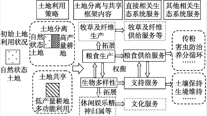
(2) 从策略本质上看,土地利用是人类活动与自然环境综合作用的结果,土地分离与共享策略选择是供给和支持两种生态系统服务之间的权衡。图1是对传统“土地分离与共享框架”的拓展:粮食生产可进一步拓展至牧草生产服务、纤维生产服务等;以生物多样性为代表的环境维持属于支持服务,但同时包含休闲娱乐和精神归属等因素,属文化服务范畴。从生态系统服务角度审视“土地分离与共享框架”,最终目的是通过选择适宜的土地利用方式实现多种服务的共赢。
(3) 从研究内容上看,粮食生产和生物多样性是土地分离与共享框架的主要内容,也是生态系统服务研究范畴。依据千年生态系统评估的分类体系(Millennium Ecosystem Assessment, 2005),粮食生产属于供给服务,并与传粉、害虫防治、养分循环等调节服务相关;生物多样性可划归为支持服务,也与土壤保持、生境维持等服务间接相关。
(4) 从研究方法上看,在土地分离与共享策略的效用评估中,粮食生产常采用粮食总产量及其市场价值估计;生物多样性常用群落内多样性(α多样性)评价,也有少量使用群落间多样性(β多样性)进行评价。生态系统服务评估同样包括对粮食供给服务和生物多样性的度量,此外还有多种模型方法对土壤保持、碳贮存等服务进行度量,从生态系统服务视角出发,可拓宽该框架中对生态系统状况的评估手段。
图1 从生态系统服务视角解析“土地分离与共享框架”
Fig.1 Land sparing versus sharing framework undera perspective from ecosystem services
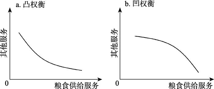
无论是土地分离还是土地共享策略,其初衷均是在保证粮食生产的同时减少对生物多样性以及生态系统服务的影响。从生物多样性的角度看,尽管有些种群的密度会随着粮食产量的增加而增大,但总体而言,粮食供给服务的提升会对区域整体生物多样性产生消极影响。
不同类型生态系统服务间关系较为复杂。若某种生态系统服务和产品的增加,会导致其他服务和产品的减少(Rodríguez et al, 2006; Bennett et al, 2007),则称生态系统服务间存在权衡(trade-offs)关系,具体到本文中,即粮食生产服务的增加,导致生物多样性或其他类型生态系统服务(以下简称“其他服务”)的减少。图2利用二维坐标系表示了这种权衡关系。随着粮食生产服务的增加,有些服务呈现加速度减少、凸向原点的衰减(图2a);有些服务呈现加速度增加、凹向原点的衰减(图2b)。根据构成曲线的形状不同,可分别命名为凸权衡(convex tradeoff)和凹权衡(concave tradeoff)(Lester et al, 2013)。其产生的原因与区域自然环境和社会经济有关(Verburg et al, 2015),如凸权衡多发生在生态脆弱、恢复力差的地区,凹权衡多发生在生态系统较为稳健、恢复力强的地区(Aillery et al, 2001; Viglizzo et al, 2006; Phalan, Balmford et al, 2011)。凹权衡状态下,在粮食供给增加的初期对其他服务影响不大,当粮食供给增加到一定程度之后,就会对其他服务有很大影响;凸权衡状态下,在粮食供给增加的初期即对生物多样性和其他服务有很大影响。权衡关系的凹凸特性影响了土地利用策略的选择,本文在如下基本假设下,通过函数证明解释策略的可能选择。
图2 生物多样性/处于权衡关系的生态系统服务与粮食供给服务间关系
Fig.2 Relationship between biodiversity/ecosystem services in trade-offs and food provision
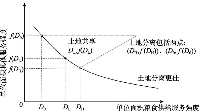
假设在原生土地状态下,单位面积粮食供给服务为D0;在土地共享策略中,低强度耕种时供给服务强度为DL;高强度耕种时供给服务强度为DH,且有D0<DL<DH;单位面积其他服务是与粮食供给服务强度相关的函数f(D);同时假设人类对于其他服务为线性的无偏好选择,即其他服务从1增加到2,与100增加到101的收益相同。在初始状态、土地共享策略中低强度耕种时、土地分离策略中高强度耕种时,其他服务量分别为f(D0)、f(DL)和f(DH),且f(D0)>f(DL)>f(DH)。土地总量为1,在土地分离策略时,保留原生态土地总量的面积为x,则进行高强度耕种的土地面积为1-x;在实行土地共享策略时土地总量也为1。
实行土地共享策略时,其他服务总量为f(DL),粮食供给服务总量为DL;在实行土地分离策略时,其他服务总量为(1-x)f(DH)+xf (D0),粮食供给服务总量为(1-x)DH+xD0;因此,在两种策略均能保证粮食供给服务的总量不下降(1-x)DH+xD0=DL这一约束下,比较f (DL)与(1-x)f(DH)+xf (D0)的大小即可判断哪种策略更为适宜。
3.2.1 生态脆弱区策略选择
在生态脆弱区域,函数形状为凸向原点,即从D0到DL点的减少速率大于从DL到DH点,即有
式中:D0为原生土地状态下单位面积粮食供给服务;DL为土地共享策略中低强度耕种时供给服务强度;DH为土地分离策略中高强度耕种时供给服务强度;f (D0)、f (DL)和f (DH)分别为初始状态、土地共享策略中低强度耕种时、土地分离策略中高强度耕种时其他服务量(以下各公式同)。
由于DL-D0<0,则:
由约束条件有:
式中:x为土地分离策略时,保留原生态土地总量的面积(以下各公式同)。联立式(2)和式(3)为:
由于f(DL)-f(D0)<0,则有:
进而,
即在生态系统较为脆弱的地区,土地分离策略较为适宜(图3),在粮食产量相同的情况下,其他服务更高,应单辟出一块自然保护区用以保护生物多样性。
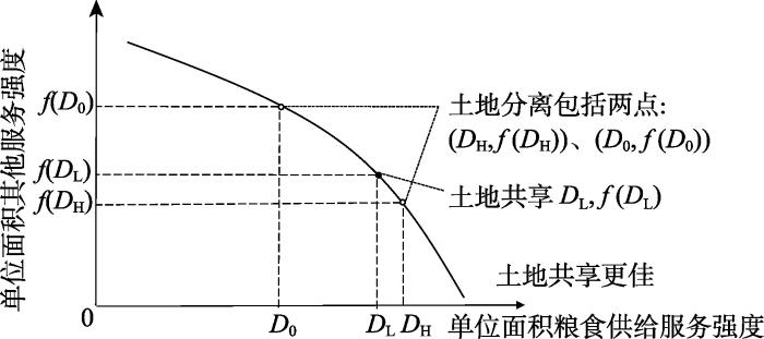
3.2.2 生态稳健区策略选择
在生态稳健区域,函数形状为凹向原点,即从D0到DL点的减少速率小于从DL到DH点,即有:
由于DL-D0<0,则:
联立约束条件式(3)和式(7)为:
由于f (DL)-f (D0)<0,则有:
进而,
即在生态系统较为稳健的地区,土地共享策略较为适宜(图4),在粮食产量相同的情况下,选择土地共享策略则其他服务更高。
综上,土地分离与共享策略的选取需要考虑生态系统异质性,取决于生物多样性或其他服务对以粮食生产为代表的人类活动的响应。在判断区域应采取哪一种策略时,应先判断当地的生态系统服务间权衡关系属于凸权衡还是凹权衡。
“土地分离与共享框架”自2005年提出以来,已应用于土地科学(von Wehrden et al, 2014)、保护生物学(Benayas et al, 2012; Quinn et al, 2012; Macchi et al, 2013)以及生态学(Bommarco et al, 2013)等多个领域。Barral等(2015)对全球54个“土地共享”或“土地分离”生态恢复工程案例进行了分析。在中国的土地利用实践中,“土地共享”策略应用较少,因此文本以美国典型土地共享工程为例,基于生态系统服务视角分析工程实施的效果,为扩大土地利用策略选择空间,更有效利用土地提供参考。
在20世纪80年代中期,美国启动了“保护储备计划”(USDA Conservation Reserve Program,以下简称“工程”)(United States Department of Agriculture Farm Service Agency, 2008)的土地共享策略,鼓励农民采用天然植被与耕地交错的方式,将田块边缘、水域边缘,或者是农田中部分易侵蚀的耕地转变为林地、草地等天然植被,以减少土壤侵蚀、增强地下水补给、提高水质,增加野生动物栖息地。这一计划的实施引发了学界的广泛关注,取得了众多研究成果,为从生态系统服务视角分析“土地共享”策略提供了素材。这一计划的分析成果,也将为中国类似工程的实施提供参考。
通过文献搜集和整理(表1),使用图1的框架对该工程进行分析。从实施的目的上看,工程旨在保护和提升当地的土壤保持、水源涵养等生态系统服务,并在一定程度上解决粮食产能过剩问题。工程实施后,不少研究表明工程达到了预期效果。在生物多样性方面,工程实施对项目区内生物多样性产生了积极影响;但有研究发现(O'Connell et al, 2012),实施土地共享策略后,由于地表径流的截留,会造成项目区下游湿地水量减少,生物多样性减少。在粮食供给方面,美国实施土地共享策略后,粮食产量呈现下降趋势(Egbert et al, 2002; Rao et al, 2010)。在原材料供给方面,美国依靠技术优势,从地表覆被增加的植物生物量中获取了大量的纤维素生物质能源(Xu et al, 2014)。土壤保持、水源涵养等调节服务以及土壤碳、氮、磷等支持服务总量也有所增加。如土壤养分方面,1985-2004年美国内布拉斯加州的盖奇县和萨利内县的土壤大颗粒物形成增加了33%,土壤氮磷总量也有明显提升(Reeder et al, 1998),同时由于野生动物数量增多,人们有了更多娱乐性的狩猎机会(Egbert et al, 2002),文化服务也有所加强。
表1 基于生态系统服务视角的美国典型土地共享框架解析
Tab.1 Analysis of the Conservation Reserve Program in the United States from ecosystem service perspective
| 策略 | 项目 | 概述 | 生物多样性或生态系统服务 | 变化 | 采样地 | 生态系统状况 | 与粮食供给服务权衡/协同状态 | 理想策略选择 | 文献 | |
|---|---|---|---|---|---|---|---|---|---|---|
| 土 地 共 享 | 保 护 储 备 计 划 | 1985年 启动,对 象为美 国范围 内自愿 参与的 农户 | 生物多样性 | 增加 周边地区减少 | 阿拉斯加腹地 新墨西哥等6州 | 脆弱 稳健 | 权衡 协同 | 分离 — | Seefeldt et al, 2010 O'Connell et al, 2012 | |
| 供给 服务 | 粮食供给 | 减少 | 科罗拉多州柯林斯堡 北达科塔州16县 | 稳健 稳健 | — | 共享 共享 | Reeder et al, 1998 Bangsund et al, 2004 | |||
| — | ||||||||||
| 生物能源材料供给 | 增加 | 堪萨斯州瓦利福尔斯 | 稳健 | 权衡 | 共享 | Xu et al, 2014 | ||||
| 水供给 | 增加 | 俄克拉荷马州得克萨斯县 | 稳健 | 权衡 | 共享 | Rao et al, 2010 | ||||
| 调节 服务 | 水质净化 | 增加 增加 | 阿拉斯加腹地 伊利诺伊州费耶特县 | 脆弱 稳健 | 权衡 | 共享 | Ribaudo, 1989 Lant, 1991 | |||
| 权衡 | 共享 | |||||||||
| 土壤保持 | 增加 增加 | 阿拉斯加腹地 堪萨斯州西南部六县 | 脆弱 稳健 | 权衡 | 共享 | Seefeldt et al, 2010 Park et al, 2005 | ||||
| 权衡 | 共享 | |||||||||
| 野生动物栖息地 | 增加 | 阿拉斯加腹地 堪萨斯州芬尼县 | 脆弱 稳健 | 权衡 | 共享 | Seefeldt et al, 2010 Egbert et al, 2002 | ||||
| 增加 | 权衡 | 共享 | ||||||||
| 支持 服务 | 土壤碳 | 增加 | 科罗拉多州柯林斯堡 | 稳健 | 权衡 | 共享 | Reeder et al, 1998 | |||
| 土壤磷 | 增加 | 内布拉斯加州盖奇县和萨利内县 | 稳健 | 权衡 | 共享 | Bach et al, 2010 | ||||
| 土壤氮 | 增加 | 科罗拉多州柯林斯堡 | 稳健 | 权衡 | 共享 | Reeder et al, 1998 | ||||
| 文化 服务 | 娱乐狩猎 | 增加 | 北达科塔州16县 | 稳健 | 权衡 | 共享 | Bangsund et al, 2004 | |||
从策略选取上看,工程实施前美国面临粮食产量过剩问题,在文献中获取的项目实施地多属于生态稳健的区域,粮食供给服务与生物多样性/其他处于权衡状态的生态系统服务间处于凹权衡状态,按照图4所示的分析,采用土地共享策略较为适宜。美国的“保护储备计划”土地共享策略在实践中也确实产生了较好的效果。
通过对美国典型土地共享工程的分析可以看出,从生态系统服务的视角出发解析土地分离与共享策略,有助于全面审视工程实施成果,特别是工程外部性效应。由于生态系统的复杂性、流动性和尺度依存的特性,局部实施的工程可能对周边地区或更大范围内的生态环境产生影响,如美国“保护储备计划”对项目区下游湿地生物多样性的负面影响。土地较为贫瘠和生态脆弱的地区生产能力有限,土地分离策略增加了高产量耕地面积,盲目增加这类区域的耕地生产率可能会造成土壤有机质下降,但土地肥沃、生产力高的地区则不存在这类问题(Ramankutty et al, 2012)。在中国土地利用规划与调整的过程中,也应充分考虑生态系统的脆弱性,在土地利用策略选择时参考国际经验,采取适宜的策略,如划分禁耕区或在生态脆弱区域建立单独的自然保护区等。
本文介绍了“土地分离与共享框架”的内涵和研究进展;分析了这一框架中所蕴含的生态系统服务权衡关系,并从权衡关系的表现形式出发,归纳了不同土地利用策略的应用条件;结合美国典型土地共享案例,阐释了土地共享策略对粮食生产等生态系统服务的影响。其结论主要包括:
(1) 人类对土地的需求从单一的粮食供给服务需求演进到粮食供给服务和其他生态系统服务的综合需求,促使“土地分离与共享”框架在生态系统服务的视角下进行拓展和深入挖掘。
(2) 当粮食供给服务与其他服务处于权衡状态时,在生态脆弱、恢复力差的地区,不同生态系统服务多表现为凸权衡关系,一般适宜采用分离策略;在生态系统稳定、恢复力强的地区,不同生态系统服务多表现为凹权衡关系,一般适宜采用共享策略。从生态系统服务的视角看,美国土地利用实践选择土地共享策略是比较适宜的。
(3) 土地利用是多要素综合影响的结果,在需要全面考虑策略实施地的实际情况。生态系统服务可在策略选择和评估实施效果中发挥评估工具的作用,为促进区域生态文明建设和可持续发展提供帮助。
(1) 解析框架的难点。从生态系统服务的视角拓展“土地分离与共享框架”,并将其运用在生态工程的效用评估中,有助于从宏观层面把握重大生态工程的顶层设计。判断两种或多种生态系统服务之间处于凸权衡或凹权衡关系是策略选择的关键,也是生态系统服务领域的热点和难点问题。现阶段由于生态系统服务研究本身有待完善,生态系统服务和土地利用之间,以及不同生态系统服务之间的关系尚未完全厘清,人类对于生态系统服务的需求和评价体系也没有形成共识,因此制定以多种生态系统服务共赢为目标的土地利用策略还有较大的研究空间。
(2) 框架自身局限。在“土地分离与共享框架”的早期研究中,“分离”或“共享”被视为非黑即白的二分选择,但越来越多的研究发现,面对高度复杂的生态系统,这并非“是”或“非”的互斥策略(Ramankutty et al, 2013),其中存在着灰色地带,可以相互融合(Lusiana et al, 2012)。例如在“分离”策略中,可在保护区或禁耕区内继续划分出完全禁止区和可“共享”使用区域,这与自然保护区中“核心区”和“实验区”的划分较为相似。土地“分离”强调从时间上给予生态环境充分的恢复,即时间上的集约,而“共享”侧重于释放更多的空间减少人类干扰来保护生态环境,因此在土地的集约利用中,也应同时考虑分离与共享的策略(Minang et al, 2013; 朱会义等, 2014)。此外,也有学者提出在农业耕作的最初即优化土地配置,比随后实施“分离”或“共享”策略更有助于区域的可持续发展(Law et al, 2015)。
(3) 对中国的启示。美国“土地保护储备计划”的成功经验为其他国家提供了重要参考。由于各国土地基础条件、权属关系和政策目标不尽相同,因此在选择“土地分离”或是“土地共享”策略时,需要有针对性的实践操作。西方国家多在私有土地中推广使用土地共享策略,因为政府无权限制私有土地中哪些地区绝对禁止耕种。在中国现行土地所有制度下,政府推行土地分离策略执行效率更高,监督成本更小,因此,中国多实施以土地分离为主的土地限制性开发政策来处理耕地和建设用地间的博弈。在耕地和生态用地间的权衡中可采用“土地共享”的策略,发掘土地的复合功能,使耕地作为绿色空间提高生态系统服务的供给。
The authors have declared that no competing interests exist.
| [1] |
传粉动物多样性的保护与农业景观传粉服务的提升 [J].https://doi.org/10.17520/biods.2014248 Magsci [本文引用: 1] 摘要
<p>传粉动物为许多植物尤其是作物提供了重要的传粉服务, 在保障全球粮食安全和人类福祉、缓冲气候变化对作物产量的影响等方面都发挥着重要的作用。然而来自全球土地利用变化、化学农药使用、外来物种入侵及气候变化等的威胁, 导致传粉动物的多样性下降并造成了依赖动物传粉的作物产量和品质的下降。针对这一情况, 作者提出了农业景观传粉动物多样性保护和利用的3种主要途径: (1)改善生产管理, 例如减少化学农药的使用、适当地采取有机种植; (2)促进景观多样性, 包括创建适宜野生传粉者的半自然生境、保护高价值的自然生境、作物多样化、合理配置资源和生境的空间分布; (3)加强对本土传粉动物的保护和开发利用。文章最后提出, 为进一步提升传粉服务, 还需加强对传粉者的生物学特征、传粉服务的需求与供给现状、影响传粉动物多样性和传粉服务的农作措施和景观因素等方面的研究。</p>
Conserving pollinator diversity and improving pollination services in agricultural landscapes [J].https://doi.org/10.17520/biods.2014248 Magsci [本文引用: 1] 摘要
<p>传粉动物为许多植物尤其是作物提供了重要的传粉服务, 在保障全球粮食安全和人类福祉、缓冲气候变化对作物产量的影响等方面都发挥着重要的作用。然而来自全球土地利用变化、化学农药使用、外来物种入侵及气候变化等的威胁, 导致传粉动物的多样性下降并造成了依赖动物传粉的作物产量和品质的下降。针对这一情况, 作者提出了农业景观传粉动物多样性保护和利用的3种主要途径: (1)改善生产管理, 例如减少化学农药的使用、适当地采取有机种植; (2)促进景观多样性, 包括创建适宜野生传粉者的半自然生境、保护高价值的自然生境、作物多样化、合理配置资源和生境的空间分布; (3)加强对本土传粉动物的保护和开发利用。文章最后提出, 为进一步提升传粉服务, 还需加强对传粉者的生物学特征、传粉服务的需求与供给现状、影响传粉动物多样性和传粉服务的农作措施和景观因素等方面的研究。</p>
|
| [2] |
|
| [3] |
土地利用变化与生态系统服务: 概念、方法与进展 [J].https://doi.org/10.11820/dlkxjz.2014.04.001 Magsci [本文引用: 1] 摘要
生态系统服务作为生态学与地理学的研究前沿和热点,受到众多学者与研究组织的关注。土地利用变化通过对生态系统格局与过程的影响,改变着生态系统产品与服务的提供能力。本文对土地利用变化与生态系统服务相关研究背景和概念进行了介绍,总结了生态系统服务评估方法的特点,对目前研究中存在的问题进行了分析,展望了未来的研究趋势。加强土地利用变化驱动下生态系统过程与服务的相互关系、生态系统服务之间的相互关系以及生态系统服务的区域集成与优化是生态系统服务研究的前沿科学问题,这些科学问题的解决将为生态系统管理提供重要的理论和方法支持。
Land-use change and ecosystem services: Concepts, methods and progress [J].https://doi.org/10.11820/dlkxjz.2014.04.001 Magsci [本文引用: 1] 摘要
生态系统服务作为生态学与地理学的研究前沿和热点,受到众多学者与研究组织的关注。土地利用变化通过对生态系统格局与过程的影响,改变着生态系统产品与服务的提供能力。本文对土地利用变化与生态系统服务相关研究背景和概念进行了介绍,总结了生态系统服务评估方法的特点,对目前研究中存在的问题进行了分析,展望了未来的研究趋势。加强土地利用变化驱动下生态系统过程与服务的相互关系、生态系统服务之间的相互关系以及生态系统服务的区域集成与优化是生态系统服务研究的前沿科学问题,这些科学问题的解决将为生态系统管理提供重要的理论和方法支持。
|
| [4] |
广州古城水系与城市发展关系研究[D] .Study on the relationship between urban canal-system of ancient Guangzhou and city development [D]. |
| [5] |
土地利用集约化研究的回顾与未来工作重点 [J].https://doi.org/10.11821/dlxb201409008 Magsci [本文引用: 1] 摘要
土地利用集约化是粮食安全、经济发展与生态保护等多重压力作用下人类土地利用的必然选择.积极推进土地利用集约化进程,使其向可持续集约化方向发展,对于中国这样人多地少的国家而言,具有尤为重要的意义.土地利用集约化研究兴起于20 世纪60 年代,但源流更远的农业生产潜力研究、农业生产要素配置研究等与土地集约利用有关的研究成果,同样加深了人们对土地利用集约化规律的认识.由于这些工作分散于多个学科领域,相关成果并未得到很好梳理.为了弥补这一不足,本文重点围绕基本特征与测度指标、极值问题与潜力研究、驱动因素与限制因素、环境影响与可持续集约化等4 个方面,简要回顾了至今为止土地利用集约化方面的主要研究成果,并概要介绍了监测和制图、路径选择、政策选择、城镇用地"集约化"等有待进一步探讨的主要问题.
Main progress in the research on land use intensification [J].https://doi.org/10.11821/dlxb201409008 Magsci [本文引用: 1] 摘要
土地利用集约化是粮食安全、经济发展与生态保护等多重压力作用下人类土地利用的必然选择.积极推进土地利用集约化进程,使其向可持续集约化方向发展,对于中国这样人多地少的国家而言,具有尤为重要的意义.土地利用集约化研究兴起于20 世纪60 年代,但源流更远的农业生产潜力研究、农业生产要素配置研究等与土地集约利用有关的研究成果,同样加深了人们对土地利用集约化规律的认识.由于这些工作分散于多个学科领域,相关成果并未得到很好梳理.为了弥补这一不足,本文重点围绕基本特征与测度指标、极值问题与潜力研究、驱动因素与限制因素、环境影响与可持续集约化等4 个方面,简要回顾了至今为止土地利用集约化方面的主要研究成果,并概要介绍了监测和制图、路径选择、政策选择、城镇用地"集约化"等有待进一步探讨的主要问题.
|
| [6] |
西南喀斯特山区石漠化贫困效应研究: 以毕节试验区为例[D] .Rocky desertification poverty effect in karst mountainous areas of Southwest China: A case study of Bijie experimental area [D]. |
| [7] |
Agriculture and ecosystem restoration in South Florida: Assessing trade-offs from water-retention development in the Everglades agricultural area [J].https://doi.org/10.1111/0002-9092.00146 URL [本文引用: 1] 摘要
ABSTRACT Agricultural production decisions can affect ecosystem function and environmental quality. Environmental restoration policies can, in turn, affect the profitability of the agricultural sector. A dynamic model of agricultural production, soil loss, and water retention in the Everglades Agricultural Area is developed to assess agricultural impacts under alternative water policy and land acquisition scenarios. Copyright 2001 by American Agricultural Economics Association
|
| [8] |
Soil texture affects soil microbial and structural recovery during grassland restoration [J].https://doi.org/10.1016/j.soilbio.2010.08.014 URL 摘要
Many biotic and abiotic factors influence recovery of soil communities following prolonged disturbance. We investigated the role of soil texture in the recovery of soil microbial community structure and changes in microbial stress, as indexed by phospholipid fatty acid (PLFA) profiles, using two chronosequences of grasslands restored from 0 to 19 years on silty clay loam and loamy fine sand soi...
|
| [9] |
Agricultural and recreational impacts of the conservation reserve program in rural North Dakota, USA [J].https://doi.org/10.1016/j.jenvman.2003.12.017 Magsci 摘要
<h2 class="secHeading" id="section_abstract">Abstract</h2><p id="">The Conservation Reserve Program (CRP), created in 1985, provides conservation benefits and agricultural supply control through voluntary, long-term retirement of crop land. While the effects of the CRP on the agricultural sector are well understood, the implications of its conservation benefits for rural economies remain largely undocumented. To quantify the effects on rural economies, this study addressed the net economic effects of decreased agricultural activity and increased recreational activity associated with the CRP in six rural areas of North Dakota from 1996 to 2000. Based on the level of economic activity that would have occurred in the absence of the program, net revenues from CRP land if returned to agricultural production in the six study areas were estimated at $50.2 million annually or $37 per acre of land currently enrolled in the CRP. Recreational (hunting) revenues as a result of the CRP in the study areas were estimated at $12.8 million annually or $9.45 per CRP-acre. The net economic effect of the CRP (lost agricultural revenues and gains in recreational expenditures) indicated that several areas of the state are not as economically burdened by the CRP as previous research has suggested. In addition, the net economic effects of the program would appear more favourable if revenues from all CRP-based recreation were included. The degree that recreational revenues offset agricultural losses might be further enhanced by enterprises that capitalize on the economic opportunities associated with expanded recreational activities on CRP lands.</p>
|
| [10] |
Quantifying the impacts of ecological restoration on biodiversity and ecosystem services in agroecosystems: A global meta-analysis [J].https://doi.org/10.1016/j.agee.2015.01.009 URL 摘要
Landscape transformation due to agriculture affects more than 40% of the planet land area and is the most important driver of losses of biodiversity and ecosystem services (ES) worldwide. Ecological restoration may significantly reduce these losses, but its effectiveness has not been systematically assessed in agroecosystems at the global level. We quantitatively meta-analyzed the results of 54 studies of how restoration actions reflecting the two contrasting strategies of land sparing and land sharing affect levels of biodiversity and ES in a wide variety of agroecosystems in 20 countries. Restoration increased overall biodiversity of all organism types by an average of 68%. It also increased the supply of many ES, in particular the levels of supporting ES by an average of 42% and levels of regulating ES by an average of 120% relative to levels in the pre-restoration agroecosystem. In fact, restored agroecosystems showed levels of biodiversity and supporting and regulating ES similar to those of reference ecosystems. Recovery levels did not correlate with the time since the last restoration action. Comparison of land sparing and land sharing as restoration strategies showed that while both were associated with similar biodiversity recovery, land sparing led to higher median ES response ratios. Passive and active restoration actions did not differ significantly in the levels of biodiversity or ES recovery. Biodiversity recovery positively correlated with ES recovery. We conclude that ecological restoration of agroecosystems is generally effective and can be recommended as a way to enhance biodiversity and supply of supporting and regulating ES in agricultural landscapes. Whether a land sharing or land sparing strategy is preferable remains an open question, and might be case dependent. Moreover, it is unclear whether crop production on restored land can meet future food production needs.
|
| [11] |
Restoration of biodiversity and ecosystem services on agricultural land [J].https://doi.org/10.1007/s10021-012-9552-0 Magsci [本文引用: 2] 摘要
Cultivation and cropping are major causes of destruction and degradation of natural ecosystems throughout the world. We face the challenge of maintaining provisioning services while conserving or enhancing other ecosystem services and biodiversity in agricultural landscapes. There is a range of possibilities within two types of intervention, namely "land sharing" and "land separation"; the former advocates the enhancement of the farmed environment, but the latter a separation between land designated for farming versus conservation. Land sharing may involve biodiversity-based agricultural practices, learning from traditional farming, changing from conventional to organic agriculture and from "simple" crops and pastures to agro-forestry systems, and restoring or creating specific elements to benefit wildlife and particular services without decreasing agricultural production. Land separation in the farmland context involves restoring or creating non-farmland habitat at the expense of field-level agricultural production-for example, woodland on arable land. Restoration by land sharing has the potential to enhance agricultural production, other ecosystem services and biodiversity at both the field and landscape scale; however, restoration by land separation would provide these benefits only at the landscape scale. Although recent debate has contrasted these approaches, we suggest they should be used in combination to maximize benefits. Furthermore, we suggest "woodland islets", an intermediate approach between land abandonment and farmland afforestation, for ecological restoration in extensive agricultural landscapes. This approach allows reconciliation of farmland production, conservation of values linked to cultural landscapes, enhancement of biodiversity, and provision of a range of ecosystem services. Beyond academic research, restoration projects within agricultural landscapes are essential if we want to halt environmental degradation and biodiversity loss.
|
| [12] |
The future of production systems in a globalized world [J].https://doi.org/10.1890%2F1540-9295%282007%295%5B191%3ATFOPSI%5D2.0.CO%3B2 URL [本文引用: 1] 摘要
AbstractHuman life is ultimately dependent on ecosystem services supplied by the biosphere. These include food, disease regulation, and recreational opportunities. Over the past 50 years, humans have changed ecosystems more rapidly and extensively than at any other time in human history, primarily to meet our growing demands for provisioning ecosystem services (eg food, freshwater, and timber). These changes have impacted other ecosystem services (eg climate regulation and erosion control). Current demand for ecosystem services is growing rapidly. How these demands are met will play a major role in determining the ecological, economic, and cultural future of the planet. While much is known about improving management of production systems to be more sustainable, research gaps remain. Challenges for ecologists include understanding the connection between management regimes, ecosystem structures and provision of multiple types of ecosystem services, understanding interactions among ecosystem services, and exploring the role of thresholds and resilience in production systems. Understanding these systems and how to manage them to ensure resilient provision of multiple ecosystem services is a key challenge for ecology.
|
| [13] |
Conservation banking mechanisms and the economization of nature: An institutional analysis [J].https://doi.org/10.1016/j.ecoser.2015.02.004 URL [本文引用: 1] 摘要
The purpose of this paper is to describe the latter, adopting an explicitly analytical stance on these complex institutional arrangements and their performative dimensions. Beyond the discourse supporting them and notwithstanding the diversity of national policies and regulatory frameworks for compensation, the constitutive force of these mechanisms probably lies in their ability to redefine control, power and the distribution of costs and in their impacts in terms of land use rather than in their efficiency.
|
| [14] |
Ecological intensification: Harnessing ecosystem services for food security [J].https://doi.org/10.1016/j.tree.2012.10.012 Magsci [本文引用: 1] 摘要
Rising demands for agricultural products will increase pressure to further intensify crop production, while negative environmental impacts have to be minimized. Ecological intensification entails the environmentally friendly replacement of anthropogenic inputs and/or enhancement of crop productivity, by including regulating and supporting ecosystem services management in agricultural practices. Effective ecological intensification requires an understanding of the relations between land use at different scales and the community composition of ecosystem service-providing organisms above and below ground, and the flow, stability, contribution to yield, and management costs of the multiple services delivered by these organisms. Research efforts and investments are particularly needed to reduce existing yield gaps by integrating context-appropriate bundles of ecosystem services into crop production systems.
|
| [15] |
Tools for exploring habitat suitability for steppe birds under land use change scenarios [J].https://doi.org/10.1016/j.agee.2014.11.013 URL [本文引用: 1] 摘要
In this study, scenario development based on changes in key socioeconomic drivers (namely, the prices of conventional food products, rural development policies and agro-environmental regulations) was used together with resource-based habitat suitability models to develop plausible visions of future pathways of agricultural land use and evaluate their potential consequences on conservation of target species. Analyses focused on three steppe bird species in a protected Natura 2000 area, located in the Iberian Peninsula. Our results showed that changes in land use composition under different scenarios can have important effects on habitat suitability, but that the size of those effects would vary depending on species-specific requirements and spatial distribution of land use changes. Positive effects of some new crops in the study area (grain legumes and aromatic plants) on studied species were suggested by our analyses. A positive effect of aggregation of land use changes was also found for two of the studied species. Scenario building and forecasting using transferable inter-disciplinary knowledge can therefore improve our capability to anticipate future changes and provide timely advice towards long-term conservation planning in agricultural systems.
|
| [16] |
The value of the world's ecosystem services and natural capital [J].https://doi.org/10.1016/S0921-8009(98)00020-2 URL [本文引用: 1] 摘要
This article provides a crude initial estimate of the value of ecosystem services to the economy. Using data from previous published studies and a few original calculations the current economic value of 17 ecosystem services for 16 biomes was estimated. The services of ecological systems and the natural capital stocks that produce them are critical to the functioning of the Earths life-support system. They contribute to human welfare both directly and indirectly and therefore represent part of the total economic value of the planet. It was estimated that for the entire biosphere the value (most of which is outside the market) ranges US$16-54 trillion/year with an average of US$33 trillion/year. Due to the nature of uncertainties this must be considered a minimum estimate. In addition the global gross national product total is around US$18 trillion/year.
|
| [17] |
To close the yield-gap while saving biodiversity will require multiple locally relevant strategies [J].https://doi.org/10.1016/j.agee.2013.04.007 URL [本文引用: 1] 摘要
Increasing yield has emerged as the most prominent element in strategies to deal with growing global demand for food and fibre. It is usually acknowledged that this needs to be done while minimising harm to the environment, but historically land-use intensification has been a major driver of biodiversity loss. The risk is now great that a singular focus on increasing yields will divert attention from the linked problem of biodiversity decline, and the historical pattern will continue. There are options that increase yields while reducing harm to biodiversity, which should be the focus of future strategies. The solutions are not universal, but are locally specific. This is because landscapes vary greatly in inherent biodiversity, the production systems they can support, and the potential for them to be adopted by landholders. While new production techniques might apply at local scale, biodiversity conservation inevitably requires strategies at landscape and larger scales.
|
| [18] |
Wildlife-friendly oil palm plantations fail to protect biodiversity effectively [J].https://doi.org/10.1111/j.1755-263X.2010.00107.x URL [本文引用: 1] 摘要
Expansion of agriculture is a principal driver of biodiversity losses in the tropics, prompting suggestions that plantations should be made more hospitable to wildlife. Such "wildlife-friendly" practices contrast with the alternative "land sparing" strategy, which promotes separation of agricultural and conservation areas. Focusing on the wildlife-friendly strategy of retaining fragments of for...
|
| [19] |
A comparison of land-sharing and land-sparing strategies for plant richness conservation in agricultural landscapes [J].
Strategies for conserving plant diversity in agroecosystems generally focus on either expanding land area in non-crop habitat or enhancing diversity within crop fields through changes in within-field management practices. In this study, we compare effects on landscape-scale species richness from such land-sharing or land-sparing strategies. We collected data in arable field, grassland, pasture, and forest habitat types (1.6 ha sampled per habitat type) across a 100-km(2) region of farmland in Lancaster County, Pennsylvania, USA. We fitted species-area relationships (SARs) for each habitat type and then combined extrapolations from the curves with estimates of community overlap to estimate richness in a 314.5-ha landscape. We then modified these baseline estimates by adjusting parameters in the SAR models to compare potential effects of land-sharing and land-sparing conservation practices on landscape richness. We found that species richness of the habitat types showed a strong inverse relationship to the relative land area of each type in the region, with 89 species in arable fields (66.5% of total land area), 153 in pastures (6.7%), 196 in forests (5.2%), and 213 in grasslands (2.9%). Relative to the baseline scenario, major changes in the richness of arable fields produced gains in landscape-scale :richness comparable to a conversion of 3.1% of arable field area into grassland habitat. Sensitivity analysis of our model indicated that relative gains from land sparing would be greatest in landscapes with a low amount of non-crop habitat in the baseline scenario, but that in more complex landscapes land sharing would provide greater gains. These results indicate that the Majority of plant species in agroecosystems are found in small fragments of non-crop habitat and suggest that, especially in landscapes with little non-crop habitat, richness can be more readily conserved through land-sparing approaches.
|
| [20] |
Using conservation reserve program maps derived from satellite imagery to characterize landscape structure [J].https://doi.org/10.1016/S0168-1699(02)00114-X URL [本文引用: 2] 摘要
The Conservation Reserve Program (CRP) instituted one of the largest and most rapid land use/land cover conversions in US history. Approximately 14.8 million ha (36.5 million acres) of cropland were converted to grassland, woodland, and other conservation uses between 1986 and 1995. As policy makers continue to evaluate the future of the program and as scientists examine its effects, it is critical that the impact of CRP on landscape structure be considered because of its potential influence on wildlife populations. Utilizing multi-seasonal Landsat thematic mapper imagery in an unsupervised classification technique, we produced highly accurate maps of cropland and grassland for 1987 and 1992 for Finney County, Kansas. Post-classification differencing identified regions of cropland that had been converted to CRP. We then used the Finney County CRP map to examine changes in landscape structure caused by the introduction of CRP. Using the FRAGSTATS spatial pattern analysis program, we calculated the number of patches, mean patch size, patch density, edge density, mean shape index, nearest neighbor distance, and an interspersion/juxtaposition index. In addition, we calculated total grassland area and percent of area in grassland for the pre- and post-CRP enrollment years. We found that the total grassland area and the percent area in grassland in Finney County increased due to CRP and that mean grassland patch size also increased. The total number of grassland patches decreased, however, due to coalescence of smaller grassland patches. Patch density, edge density, mean shape index, nearest neighbor distance, and the interspersion/juxtaposition index all showed relatively small changes. These small changes appear to reflect geographic differences in CRP effects within the county-large aggregating patches in the northeast were offset by a number of isolated patches of CRP in other areas. The implication of these findings for wildlife managers is that, for species that require large areas of grassland habitat, especially habitat that is contiguous, CRP in Finney County represents a substantial increase in potential habitat. This holds for species at all levels of management interest, ranging from economically valuable species to species that are rare, threatened, and endangered. These findings emphasize the importance of CRP for wildlife conservation and should further inform ongoing debate concerning the importance of the CRP.
|
| [21] |
Land sparing versus land sharing: Moving forward [J]. |
| [22] |
Should agricultural policies encourage land sparing or wildlife-friendly farming [J].https://doi.org/10.1890/070019 URL [本文引用: 2] 摘要
As the demands on agricultural lands to produce food, fuel, and fiber continue to expand, effective strategies are urgently needed to balance biodiversity conservation and agricultural production. “Land sparing” and “wildlife-friendly farming” have been proposed as seemingly opposing strategies to achieve this balance. In land sparing, homogeneous areas of farmland are managed to maximize yields, while separate reserves target biodiversity conservation. Wildlife-friendly farming, in contrast, integrates conservation and production within more heterogeneous landscapes. Different scientific traditions underpin the two approaches. Land sparing is associated with an island model of modified landscapes, where islands of nature are seen as separate from human activities. This simple dichotomy makes land sparing easily compatible with optimization methods that attempt to allocate land uses in the most efficient way. In contrast, wildlife-friendly farming emphasizes heterogeneity, resilience, and ecological inter...
|
| [23] |
Farming and the fate of wild nature [J]. |
| [24] |
Food security versus biodiversity protection: An example of land-sharing from East Africa [J].https://doi.org/10.1007/s10531-013-0479-3 Magsci [本文引用: 1] 摘要
The recent controversial debate on land-sharing versus land-sparing is clearly exemplified in the East African mountains, one of the most diverse biodiversity hotspots on our planet. In these areas, species richness is particularly concentrated in the mountain cloud forests which are surrounded by a sea of dry lowland savannas heavily encroached on by local communities. Sustainable land use practices in the lowlands, however, are necessary to safeguard the natural capital at higher elevations. The interdependence between sustainable land-use and conservation of biodiversity hotspots was underlined during a workshop held in the rural areas of Kenya, East Africa, early spring 2013. It was concluded that close links between livelihoods, natural capital and poverty remains a fundamental challenge in East Africa's forest conservation efforts.
|
| [25] |
Comparative review of multifunctionality and ecosystem services in sustainable agriculture [J].https://doi.org/10.1016/j.jenvman.2014.10.020 URL PMID: 25463579 [本文引用: 1] 摘要
Abstract Two scientific communities with broad interest in sustainable agriculture independently focus on multifunctional agriculture or ecosystem services. These communities have limited interaction and exchange, and each group faces research challenges according to independently operating paradigms. This paper presents a comparative review of published research in multifunctional agriculture and ecosystem services. The motivation for this work is to improve communication, integrate experimental approaches, and propose areas of consensus and dialog for the two communities. This extensive analysis of publication trends, ideologies, and approaches enables formulation of four main conclusions. First, the two communities are closely related through their use of the term "function." However, multifunctional agriculture considers functions as agricultural activity outputs and prefers farm-centred approaches, whereas ecosystem services considers ecosystem functions in the provision of services and prefers service-centred approaches. Second, research approaches to common questions in these two communities share some similarities, and there would be great value in integrating these approaches. Third, the two communities have potential for dialog regarding the bundle of ecosystem services and the spectrum of multifunctional agriculture, or regarding land sharing and land sparing. Fourth, we propose an integrated conceptual framework that distinguishes six groups of ecosystem services and disservices in the agricultural landscape, and combines the concepts of multifunctional agriculture and ecosystem services. This integrated framework improves applications of multifunctional agriculture and ecosystem services for operational use. Future research should examine if the framework can be readily adapted for modelling specific problems in agricultural management. Copyright 2014 Elsevier Ltd. All rights reserved.
|
| [26] |
Potential of the Conservation Reserve Program to control agricultural surface water pollution [J].URL 摘要
The Conservation Reserve Program (CRP), initiated by the Conservation Title of the Food Security Act of 1985, is the primary federal program to control nonpointsource pollution in agricultural watersheds of the United States. However, the program is designed primarily to reduce soil erosion rather than to retire croplands in a manner optimal for controlling runoff of sediment and associated pollutants. This study estimates potential enrollment of streamside and floodplain croplands in this ten-year retirement program in order to gauge the potential of the CRP as a water-quality improvement policy. A contingent choice survey design was employed in Fayette County, Illinois, to demonstrate that there is substantial potential for retirement of streamside and floodplain croplands in the CRP. Enrollments in each program climb from less than 6% to over 83% of eligible croplands as the annual rental rate is increased from $20 to $200/acre. Potential retirement of streamside and floodplain croplands declines, however, if tree planting, drainage removal, or a 20-year contract are required. The potential of a CRP-based water-quality program to improve water quality and aquatic ecosystems in agricultural watersheds is thus substantial but constrained by the economic trade-offs that farmers make between crop production and conservation incentives in determining the use of their riparian lands.
|
| [27] |
Better land-use allocation outperforms land sparing and land sharing approaches to conservation in Central Kalimantan, Indonesia [J].https://doi.org/10.1016/j.biocon.2015.03.004 URL [本文引用: 2] 摘要
Land sparing and land sharing are contrasting strategies often aimed at improving both agricultural production and biodiversity conservation in multifunctional landscapes. These strategies are embodied in land management policies at local to international scales, commonly in conjunction with other land-use policies. Evaluation of these strategies at a landscape scale, for multiple ecosystem service benefits, and multiple elements of biodiversity has not previously been attempted. We simulated the effects of applying land sharing and land sparing strategies to the agricultural zones designated by four future land-use scenarios (reflecting both current land-use and prospective land-use plans) in the Ex-Mega Rice Project region of Central Kalimantan, Indonesia. We assessed impacts of each strategy on biodiversity, agricultural production, and other ecosystem service benefits at a landscape scale. We examined whether it was possible to achieve predetermined targets that reflect the aspirations and entitlements of diverse stakeholder groups. We found that the prospective land-use plans for the region would deliver considerably more benefit than the current land-use allocations, and while not all targets can be achieved, additional progress could be made with reasonable and realistic levels of land sharing or sparing. We found that species and forest types sensitive to agricultural disturbance could benefit most if land in agricultural zones was spared and prioritised for conservation. Conversely, land sharing strategies favoured the more widespread and common species, particularly if the area of wildlife-friendly agriculture is increased. However, the effectiveness of agricultural-focused land management strategies is inherently limited by the extent of agricultural zones. While agricultural land sparing and sharing strategies can deliver some gains in target achievement for multiple ecosystem services, we find that they have a limited effect over the benefits achieved by implementing better land-use allocation from the outset.
|
| [28] |
Revisiting production and ecosystem services on the farm scale for evaluating land use alternatives [J].https://doi.org/10.1016/j.envsci.2015.11.015 URL [本文引用: 2] 摘要
This paper presents a framework to assess all ecosystem services (i.e. marketable and non-marketable ES) delivered by conventional as well as innovative land uses. The framework is then used to assess land use strategies at the scale of an unconventional case farm in Flanders, Belgium. The analysis combines spatial and economic analysis of land use alternatives and illustrates some shortcomings of usual ecosystem valuation tools. Our findings illustrate that land use evaluation might be biased against unconventional land management alternatives. The proposed framework provides land planners with a way to assess and arbitrate between land sharing and land sparring options more accurately. The approach can help to optimize land use from the societal perspective, and allows for benchmarking farm-level land use alternatives by comparing the services they deliver.
|
| [29] |
Evaluating tradeoffs among ecosystem services to inform marine spatial planning [J].https://doi.org/10.1016/j.marpol.2012.05.022 URL Magsci [本文引用: 1] 摘要
A central challenge for natural resource management is developing rigorous yet practical approaches for balancing the costs and benefits of diverse human uses of ecosystems. Economic theory has a long history of evaluating tradeoffs in returns from different assets to identify optimal investment strategies. There has been recent progress applying this framework to the delivery of ecosystem services in land use planning. However, despite growing national and international interest in marine spatial planning, there is a lack of parallel frameworks in the marine realm. This paper reviews an ecosystem service tradeoff analysis framework and provides a more comprehensive synthesis for how it can be applied to marine spatial planning and marine ecosystem-based management. A tradeoff analysis approach can reveal inferior management options, demonstrate the benefits of comprehensive planning for multiple, interacting services over managing single services, and identify 'compatible' services that provide win-win management options. (C) 2012 Elsevier Ltd. All rights reserved.
|
| [30] |
Land sparing or sharing: Exploring livestock fodder options in combination with land use zoning and consequences for livelihoods and net carbon stocks using the FALLOW model [J].https://doi.org/10.1016/j.agee.2012.07.006 URL [本文引用: 3] 摘要
Livestock as an integral part of farming systems can increase resource use efficiency and land use intensity of agricultural systems, but can also be a driver of forest conversion and associated greenhouse gas emissions. Forest policies that limit land use options may be able to halt forest change, if strongly enforced, but concurrently may also reduce livestock carrying capacity. This study explored the use of the spatially explicit FALLOW model, with a new livestock module, to assess the impact of land use zoning strategies, in combination with access to fodder harvesting, on welfare, fodder availability and landscape stocks in the Upper Konto catchment, Indonesia. The existing land zoning in Upper Konto catchment is in name ‘land-sparing’ but de facto combined with ‘land sharing’ approach with access to cut and carry fodder sources in watershed protection areas. Scenario analysis revealed that the existing land zoning approach is the most promising in terms of balancing fodder availability, farmers’ welfare (total profits gained from production in the landscape minus products consumed by people living in the area) and ecosystem functions (with above-ground stocks as indicator). A pure land sparing approach with agricultural intensification indicates increase in farmers’ welfare but with a higher decrease (in percentage) of landscape above-ground stocks. Hence, careful integration of livestock systems into zoned conservation areas can achieve multiple goals including enhancing peoples’ livelihoods and protecting environmental services.
|
| [31] |
Trade-offs between land use intensity and avian biodiversity in the Dry Chaco of Argentina: A tale of two gradients [J].https://doi.org/10.1016/j.agee.2013.04.011 URL [本文引用: 1] 摘要
Studies to assess the relationship between agriculture production and biodiversity conservation usually focus on one gradient ranging from a natural reference land cover type (typically forest) to an intensive productive land use. However, many semi-arid ecoregions such as the dry Chaco are characterized by a mosaic of different land covers, including natural grasslands and woody vegetation with different degrees of transformation, frequently aimed at meat production. We analyzed the associations between avian biodiversity and meat productivity of forest, natural grasslands, three types of livestock production systems, and soybean crops in northern Argentina dry Chaco; an area of c. 19 million02ha characterized by high conservation value and rapid land use change. A Generalized Lineal Model analysis of reports and publications quantified a meat productivity range in which soybean (the less diverse land cover type) doubles the most efficient livestock systems, and is eight times more productive than the widespread puestos system. A multidimensional scaling ordination identified two independent gradients of bird's response to increasing land use intensity, respectively from protected forests and from natural grasslands, to highly transformed systems. Along both gradients avian richness and density sharply declined in the transition from semi-natural land covers to planted pastures and similarity to native grasslands and protected forests decreased exponentially. Along the “grasslands gradient”, bird richness and density presented a unimodal response. Maximum likelihood-fitted curves of bird's guilds response to the productivity gradients showed that in the “forest gradient” most guilds decreased exponentially or linearly, whereas in the “grasslands gradient” most guilds peaked at intermediate levels of meat yield. Our results suggest that land sparing strategies can be more efficient to balance agriculture production with the conservation of forest avian diversity, but also that the prevailing “forest oriented” conservation schemes (e.g. Argentine Forest Law) do not capture the complexity of the system and both forests and grassland gradients should be considered in land use planning, possibly including a combination of conservation strategies.
|
| [32] |
Reshaping agri-environmental subsidies: From marginal farming to large-scale rewilding [J]. |
| [33] |
|
| [34] |
Design challenges for achieving reduced emissions from deforestation and forest degradation through conservation: Leveraging multiple paradigms at the tropical forest margins [J].https://doi.org/10.1016/j.landusepol.2012.04.025 URL [本文引用: 1] 摘要
Reduced emissions from deforestation and forest degradation in developing countries (REDD+) is widely accepted as a land use policy objective for mitigating climate change, but the ways through which REDD+ can provide incentives to simultaneously conserve forest and reduce poverty remain uncertain. The experiences of integrated conservation and development projects (ICDPs) have shaped initial pilots of landscape level REDD+ action. Yet, little thought has been given to the design challenges that need to be overcome in multi-scale REDD+ programs, where local shifts of behavior need to be connected to international finance and investment. This paper highlights and discusses emerging design challenges for REDD+ at multiple levels in two distinct circumstances. First, for sub-national REDD+ design where ICDP approaches are employed as a platform for demonstration and project design and implementation. In this case, issues of scale, nesting and leakage are prominent. Secondly, ICDP is used as a strategy for implementation of REDD+ at multiple levels. In the second case, the challenges are about choices or optimal mixes between multiple policies and instruments such as “sparing” and “sharing” for addressing drivers of deforestation and payments, rewards and/or co-investments in the achievement of multiple co-benefits of emission reductions. The paper also explores how combinations of incentive paradigms can be used at the local, sub-national and national scale within a nested approach to REDD+ as derived from distinguishing features of REDD+ such as performance measurements, financial modalities and carbon as a commodity that have not hitherto been part of ICDPs. We posit that a nested land-based Nationally Appropriate Mitigation Actions (NAMAs) approach could overcome design issues with REDD+ frameworks that use additional co-investment for achieving biodiversity goals on a modified ICDP platform.
|
| [35] |
Land sharing vs. land sparing in the dry Caribbean lowlands: A dung beetles' perspective [J]. |
| [36] |
A global model of the response of tropical and sub-tropical forest biodiversity to anthropogenic pressures [J].https://doi.org/10.1098/rspb.2014.1371 URL [本文引用: 1] 摘要
Habitat loss and degradation, driven largely by agricultural expansion and intensification, present the greatest immediate threat to biodiversity. Tropical forests harbour among the highest levels of terrestrial species diversity and are likely to experience rapid land-use change in the coming decades. Synthetic analyses of observed responses of species are useful for quantifying how land use affects biodiversity and for predicting outcomes under land-use scenarios. Previous applications of this approach have typically focused on individual taxonomic groups, analysing the average response of the whole community to changes in land use. Here, we incorporate quantitative remotely sensed data about habitats in, to our knowledge, the first worldwide synthetic analysis of how individual species in four major taxonomic groups--invertebrates, 'herptiles' (reptiles and amphibians), mammals and birds--respond to multiple human pressures in tropical and sub-tropical forests. We show significant independent impacts of land use, human vegetation offtake, forest cover and human population density on both occurrence and abundance of species, highlighting the value of analysing multiple explanatory variables simultaneously. Responses differ among the four groups considered, and--within birds and mammals--between habitat specialists and habitat generalists and between narrow-ranged and wide-ranged species.
|
| [37] |
Influence of land-use and conservation programs on wetland plant communities of the semiarid United States Great Plains [J].https://doi.org/10.1016/j.biocon.2011.11.030 Magsci [本文引用: 1] 摘要
Depressional wetlands are predominant surface hydrological features providing critical societal ecosystem services in the semiarid United States High Plains. Critical wetland properties may be threatened because this 30 million ha short-grass prairie largely was converted from grassland to cropland. Further, the United States Department of Agriculture enrolled marginal cropland into the Conservation Reserve Program (CRP). CRP reduces topsoil erosion by planting permanent cover on croplands. In the High Plains, introduced tall-grasses primarily were planted in CRP, possibly reducing precipitation runoff, an important hydroperiod driver in wetlands. We assessed land-use influence on important wetland processes (wetland area, inundation, and plant composition) in 261 depressional wetlands called playas (87 each in native grassland, CRP, and cropland). Surveys spanned six states within three High Plains sub-regions (southern, central and northern). Playas averaged 8 ha in cropland and 16 ha in other land-uses. Plant composition in grassland playas was predominately native perennials, and upland plant cover equaled wetland plant cover. Cropland playas had fewer species/ha, generally more annuals than perennials and 80% greater exposed ground than other land-uses. CRP playas had 400% greater cover of introduced species (mostly upland perennial tall-grasses), which possibly inhibited catchment runoff, as CRP playas were inundated 56% less often than other land-uses. Therefore, tall grasses should not be planted in short-grass prairie CRP catchments, as they alter inundation frequency and vegetation communities in embedded wetlands. Conservation programs containing provisions to protect playas, including planting common native species and using grass buffers to control erosion into wetlands, should be promoted. (C) 2011 Elsevier Ltd. All rights reserved.
|
| [38] |
Assessment of soil erodibility indices for conservation reserve program lands in southwestern Kansas using satellite imagery and GIS techniques [J].https://doi.org/10.1007/s00267-003-0309-6 Magsci 摘要
<a name="Abs1"></a>The soil erodibility index (EI) of Conservation Reserve Program (CRP) lands, which was the major criterion for CRP enrollment, was assessed for six counties in southwestern Kansas using USGS seamless digital elevation model data and Geographical Informational System techniques. The proportion of land areas with EI values of 8 or lower was less than 1% of the entire study area and most of the land areas (72.5%) were concentrated on EI values between 8 and 24. Although land acreage with EI values of 24 or higher decreased dramatically, the proportion of CRP lands to the other land-use types did not change much from low to high EI levels. The soil EI and physical soil characteristics of the CRP lands were compared to those of other land-use types. In general, the mean EI values of the land-use types were strongly correlated with physical soil properties, including organic matter content, clay content, available water capacity, permeability, and texture. CRP lands were compared in detail with cropland in terms of their soil characteristics to infer the pivotal cause of the land transformation. Although there was no significant statistical difference in EI between cropland and CRP soils, soil texture, soil family, and permeability were statistically different between the two. Statistical analyses of these three variables showed that CRP soils had coarser texture and higher permeability on average than cropland soils, indicating that CRP lands in the study area are drier than cropland soils. Therefore, soil moisture characteristics, not necessarily soil erosion potential, might have been the key factor for CRP enrollment in the study area.
|
| [39] |
Minimising the harm to biodiversity of producing more food globally [J].https://doi.org/10.1016/j.foodpol.2010.11.008 URL [本文引用: 1] 摘要
Should farming and conservation policies aim broadly to separate land for nature and land for production (land sparing) or integrate production and conservation on the same land (wildlife-friendly farming)? Most studies that try to address this question suffer from flaws in sampling design, inappropriate metrics, and/or failure to measure biodiversity baselines. We discuss how these failings can be addressed, and what existing information tells us about the key debates on this topic. The evidence available suggests that trade-offs between biodiversity and yield are prevalent. While there are some wildlife-friendly farming systems that support high species richness, a large proportion of wild species cannot survive in even the most benign farming systems. To conserve those species, protection of wild lands will remain essential. Sustainable intensification could help to facilitate sparing of such lands, provided that as much attention is given to protecting habitats as to raising yields. We discuss the general circumstances under which yield increases can facilitate land sparing, recognising that policies and social safeguards will need to be context-specific. In some situations, bringing degraded lands into production could help reduce pressure on wild lands, but much more information is needed on the biodiversity implications of using degraded lands. We conclude that restricting human requirements for land globally will be important in limiting the impacts on biodiversity of increasing food production. To achieve this, society will need to integrate explicit conservation objectives into local, regional and international policies affecting the food system.
|
| [40] |
Reconciling food production and biodiversity conservation: Land sharing and land sparing compared [J].https://doi.org/10.1126/science.1208742 URL PMID: 21885781 [本文引用: 1] 摘要
The question of how to meet rising food demand at the least cost to biodiversity requires the evaluation of two contrasting alternatives: land sharing, which integrates both objectives on the same land; and land sparing, in which high-yield farming is combined with protecting natural habitats from conversion to agriculture. To test these alternatives, we compared crop yields and densities of bird and tree species across gradients of agricultural intensity in southwest Ghana and northern India. More species were negatively affected by agriculture than benefited from it, particularly among species with small global ranges. For both taxa in both countries, land sparing is a more promising strategy for minimizing negative impacts of food production, at both current and anticipated future levels of production.
|
| [41] |
The effects of land sparing and wildlife-friendly practices on grassland bird abundance within organic farmlands [J].https://doi.org/10.1016/j.agee.2012.07.021 URL [本文引用: 1] 摘要
Biodiversity is often greater in organic farm systems than non-organic. However, variation in land use within organic systems limits absolute statements about its value for species conservation. Thus, a need is evident to better understand what practices associated with organic farming benefit conservation. We modeled abundance, within organic systems, of six grassland birds of conservation concern as an outcome of applied wildlife-friendly and land sparing practices at multiple spatial scales. We used a Poisson-binomial model to estimate the relative effect of abundance drivers while accounting for detectability. At the field scale, species response to vegetation structure was mixed. At a local scale, Dickcissels were more abundant at points with greater percentage of alfalfa and soybean. Three species were less abundant at points with a greater percent of local woodland and there was no significant response to local linear grass. Grasshopper Sparrows were more abundant at points with more local block grassland. At a landscape scale, Western Meadowlarks and Ring-necked Pheasants were more abundant at points with a greater percent of grassland in the landscape. Results highlight the importance of a multiscale approach and demonstrate that effective management of species should consider costs and benefits of wildlife-friendly and land sparing practices.
|
| [42] |
Can intensive farming save nature [J]. |
| [43] |
Land sparing or land sharing: Context dependent [J].https://doi.org/10.1890/13.WB.010 Magsci [本文引用: 1] |
| [44] |
Groundwater impacts due to conservation reserve program in Texas County, Oklahoma [J].https://doi.org/10.1016/j.apgeog.2009.08.006 Magsci [本文引用: 1] 摘要
<h2 class="secHeading" id="section_abstract">Abstract</h2><p id="">The Conservation Reserve Program (CRP) is one of the largest programs of the U.S. Department of Agriculture (USDA) that encourages farmers and ranchers to establish resource-conserving vegetative covers to address soil, water and related resource issues on their lands. This research study examines the relationship between the CRP and the changes in the groundwater levels within Texas County in the Oklahoma Panhandle region. The region overlies the central portion of the High Plains Aquifer that has shown significant decline in groundwater levels, due largely to the development of irrigated agriculture. Using the calibrated SWAT (Soil and Water Assessment Tool) model and GIS-based analysis, a significant spatial correlation (<em>γ</em> = −0.81 at 90% confidence level) was observed between the percentage of CRP and the difference in groundwater levels between 1990 and 2000 time periods. Thus, there is a significant potential for the CRP to increase groundwater recharge and help decrease the rate of decline in groundwater levels. Studies such as this will help justify long-term environmental benefits of the CRP, and also greatly aid in policy formulation. Additionally, we demonstrate the application of GIS-based modeling approach to facilitate efficient and effective decision making in land use planning.</p>
|
| [45] |
Soil C and N changes on conservation reserve program lands in the Central Great Plains [J].https://doi.org/10.1016/S0167-1987(98)00122-6 URL [本文引用: 1] 摘要
The Conservation Reserve Program (CRP) was initiated to reduce water and wind erosion on marginal, highly erodible croplands by removing them from production and planting permanent, soil-conserving vegetation such as grass. We conducted a field study at two sites in Wyoming, USA, in order to quantify changes in soil C and N of marginal croplands seeded to grass, and of native rangeland plowed and cropped to wheat–fallow. Field plots were established on a sandy loam site and a clay loam site on wheat–fallow cropland that had been in production for 60+ years and on adjacent native rangeland. In 1993, 6 years after the study was initiated, the surface soil was sampled in 2.502cm depth increments, while the subsurface soil was composited as one depth increment. All soil samples were analyzed for total organic C and N, and potential net mineralized C and N. After 60+ years of cultivation, surface soils at both study sites were 18–26% lower (by mass) in total organic C and N than in the A horizons of adjacent native range. Six years after plowing and converting native rangeland to cropland (three wheat–fallow cycles), both total and potential net mineralized C and N in the surface soil had decreased and NO 3 –N at all depths had increased to levels found after 60+ years of cultivation. We estimate that mixing of the surface and subsurface soil with tillage accounted for 40–60% of the decrease in surface soil C and N in long-term cultivated fields; in the short-term cultivated fields, mixing with tillage may have accounted for 60–75% of the decrease in C, and 30–60% of the decrease in N. These results emphasize the need to evaluate C and N in the entire soil solum, rather than in just the surface soil, if actual losses of C and N due to cultivation are to be distinguished from vertical redistribution. Five years after reestablishing grass on the sandy loam soil, both total and potential net mineralized C and N in the surface soil had increased to levels equal to or greater than those observed in the A horizon of the native range. On the clay loam soil, however, significant increases in total organic C were observed only in the surface 2.502cm of N-fertilized grass plots, while total organic N had not significantly increased from levels observed in the long-term cultivated fields.
|
| [46] |
Targeting the conservation reserve program to maximize water quality benefits [J].https://doi.org/10.2307/3146800 URL 摘要
In this paper, three schemes for targeting a soil conservation program for the purpose of improving water quality are examined, using the, CRP as an example. One approach is based on physical measures of water quality and two on economic damages to water users. These targeting approaches were chosen because they usc data likely to be available to agencies making targeting decisions. Differences in geographic location of targeted cropland will be examined. Economic benefits to water users from removing cropland from production will then be estimated and compared. The analysis was performed at a very large regional level. Any targeting scheme for an actual program would necessarily have to be at a much smaller regional scale. The goal of this paper is to demonstrate how the economic efficiency of a program might be increased, rather than to assess the actual magnitude of improved efficiency.
|
| [47] |
Trade-offs across space, time, and ecosystem services [J]. |
| [48] |
Land sparing or land sharing: The missing link [J].https://doi.org/10.1890/13.WB.008 Magsci [本文引用: 1] |
| [49] |
Vegetation changes in conservation reserve program lands in interior Alaska [J].https://doi.org/10.1016/j.agee.2009.09.001 URL 摘要
Over 14 million hectares of prone cropland in the United States has been converted into grasslands through the Conservation Reserve Program (CRP) administered by the United States Department of Agriculture, however, studies of the effects of CRP enrollment on plant communities and subsequent plant succession are largely lacking. In Junction, Alaska plant communities in CRP fields are transitioning from grasslands to shrub dominated plant communities, which are resulting in compliance problems with program regulations that state ields must be maintained in a condition that permits easy conversion to cropland. To determine plant succession and how previous land management and soils might influence the transition, we measured plant populations in 20 CRP fields throughout Junction using modified-Whittaker plots. These data were combined with data on current management practices, previous farming history, soils, soil properties, diversity indices, and time since land was cleared and analyzed with nonmetric multidimensional scaling ordination to determine factors that influence plant succession. Time in the CRP was the only factor consistently influencing plant succession. As time in the CRP increased, the planted introduced grasses grass () and red fescue () and the native pteridophyte () decreased, whereas a native grass (Calamigrostis canadensis), five native forb, two native shrub, and three native tree species increased. Plant diversity increased at a rate of more than 2 species per 1000m/2; per year. Regression analyses of plant species and plant groups using time in the CRP as the dependent variable resulted in the identification of outlier CRP fields with significantly more or less than expected covers of vegetation. All fields with these outliers had reasonable explanations for the differences in cover that were unrelated to the overall rate of plant succession. Current management practices will result in incompliant fields and different management practices that result in woody vegetation control is key to maintaining CRP fields in compliance.
|
| [50] |
Conservation Reserve Program: Summary and enrollment statistics[R]. |
| [51] |
Land system science and sustainable development of the earth system: A global land project perspective [J].https://doi.org/10.1016/j.ancene.2015.09.004 URL [本文引用: 1] 摘要
Land systems are the result of human interactions with the natural environment. Understanding the drivers, state, trends and impacts of different land systems on social and natural processes helps to reveal how changes in the land system affect the functioning of the socio-ecological system as a whole and the tradeoff these changes may represent. The Global Land Project has led advances by synthesizing land systems research across different scales and providing concepts to further understand the feedbacks between social-and environmental systems, between urban and rural environments and between distant world regions. Land system science has moved from a focus on observation of change and understanding the drivers of these changes to a focus on using this understanding to design sustainable transformations through stakeholder engagement and through the concept of land governance. As land use can be seen as the largest geo-engineering project in which mankind has engaged, land system science can act as a platform for integration of insights from different disciplines and for translation of knowledge into action.
|
| [52] |
Land-use options for Del Plata Basin in South America: Tradeoffs analysis based on ecosystem service provision [J].https://doi.org/10.1016/j.ecolecon.2005.03.025 URL [本文引用: 1] 摘要
By Ernesto F. Viglizzo and Federico C. Frank; Land-use options for Del Plata Basin in South America: Tradeoffs analysis based on ecosystem service provision
|
| [53] |
Realigning the land-sharing/land-sparing debate to match conservation needs: Considering diversity scales and land-use history [J].https://doi.org/10.1007/s10980-014-0038-7 Magsci [本文引用: 3] 摘要
The "land sharing versus land sparing" concept provides a framework for comparing potential land use patterns in terms of trade-offs between biodiversity conservation and agricultural yields at a landscape scale. Here, we raise two additional aspects to be considered in the sparing/sharing debate, supported by a review of available literature. First, beta and gamma (instead of alpha) diversity measures capture landscape scale variance in biodiversity in response to land use changes and should be considered for the long-term management of agricultural landscapes. Moreover, beta and gamma diversity may better account for comparisons of biodiversity between spared and shared land use options. Second, land use history has a pronounced influence on the complexity and variance in agricultural habitat niches at a landscape scale, which in turn may determine the relevance of sparing or sharing land use options. Appropriate and comparable biodiversity metrics and the recognition of landscape history are two vital preconditions in aligning biological conservation goals with maximized yields within the sparing/sharing framework.
|
| [54] |
Torrefaction of conservation reserve program biomass: A techno-economic evaluation [J].https://doi.org/10.1016/j.indcrop.2014.07.030 URL Magsci [本文引用: 1] 摘要
The Conservation Reserve Program (CRP), which was initiated to prevent soil erosion, provides a large amount of cellulosic biomass that is potentially useful for bioenergy production. We investigated the effects of torrefaction conditions on the physicochemical properties of CRP biomass using an elemental analyzer, a thermogravimetric analyzer, and a calorimeter. Results suggest that the upgraded biomass is a hydrophobic, high-energy density, and low-moisture-content material. The study on biomass polymer composition showed how polymer components changed with processing conditions. The polysaccharides in biomass were degraded significantly at 300 degrees C, suggesting that processing conditions should be managed properly for sugar or energy recovery. Our economic analysis suggested that the processing cost for a torrefaction plant with an annual capacity of 100,000 tons of CRP biomass is $16.3 per ton of feedstock. Further analysis of the effects of torrefaction on the biomass supply chain suggested that processing could save pelletization and transportation costs. Published by Elsevier B.V.
|
| [55] |
Comparable benefits of land sparing and sharing indicated by bird responses to stand-level plantation intensity in Hokkaido, northern Japan [J].https://doi.org/10.1007/s10310-014-0453-2 URL [本文引用: 1] 摘要
We examined potentially contrasting conservation benefits of land sparing (land-use specialization) and land sharing (multiple-use forestry) strategies in forested landscapes by investigating relationships between bird functional group densities and basal areas of coniferous trees (an index of plantation intensity) in Sakhalin fir ( Abies sachalinensis ) and Sakhalin spruce ( Picea glehnii ) plantations. Densities of most bird functional groups increased with decreasing plantation intensity in both plantation types. In many cases, linear models were best for descriptors of bird density lantation intensity relationships, but statistical support of linear and nonlinear (quadratic) models was similar. This outcome indicates that ecological benefits of land sparing and land sharing are potentially comparable in the plantations we studied. In real landscapes, land-use decision making depends on a variety of factors other than biodiversity conservation (e.g., social and biophysical factors). Furthermore, niche theory also predicts that population densities could linearly respond to environmental gradients. When density ntensity relationships are linear, as in this study, land-sparing and land-sharing strategies provide similar benefits in terms of biodiversity conservation, and contrasting land-use strategies could be flexibly chosen to enhance the accommodation of biodiversity conservation to resource production.
|

/
| 〈 |
|
〉 |