盛贺伟 , 孙莉英, 蔡强国
SHENG Hewei, SUN Liying, CAI Qiangguo
通讯作者:
版权声明: 2016 地理科学进展 《地理科学进展》杂志 版权所有
基金资助:
作者简介:
作者简介:盛贺伟(1990-),男,河南驻马店人,硕士研究生,主要从事土壤侵蚀机理研究,E-mail:heweisheng@nwsuaf.edu.cn。
展开
摘要
黄土高原地区坡面土壤侵蚀具有明显的垂直分带性,溅蚀片蚀带是坡面侵蚀的最上方地带,研究片蚀过程含沙量变化有助于阐明坡面侵蚀规律。本文采用人工模拟降雨试验方法研究了黄土坡面片蚀稳定含沙量及其影响因素;试验处理包括2种质地的黄土(塿土和黑垆土),2个雨强(90和120 mm/h)和4个坡度(10°、15°、20°和25°)。结果表明:在不同质地黄土、降雨强度和坡度条件下,水流含沙量均呈现先减小后平稳的规律;稳定含沙量与土壤颗粒体积分形维数、降雨强度和坡度呈幂函数关系,稳定含沙量随土壤颗粒体积分形维数的增大而减小,随降雨强度和坡度的增大而增大,影响程度依次为土壤颗粒体积分形维数、降雨强度和坡度;所分析的水动力学指标中单位水流功率与稳定含沙量关系最密切,降雨强度对稳定含沙量的影响大于单位水流功率。
关键词:
Abstract
Soil erosion on the loess hillslope shows clear vertical zonal differentiation. From upslope to downslope locations, the erosion zones are sheet erosion zone, rill erosion zone, and shallow gully erosion zone. Sediment concentration of sheet erosion zone has important impacts on detachment, deposition, and transportation processes of rill erosion zone. The purpose of this study was to investigate the relationship between steady sediment concentration and different influencing factors including loess soil type, rainfall intensity, and slope gradient. The relationship between steady sediment concentration and shear stress, stream power, and unit stream power were also examined. The impacts of loess soil type, rainfall intensity, and slope gradient on sediment concentration in rain-induced sheet flow were examined by artificial rainfall experiment from June to August 2015. Two loess soils from Yangling and Changwu districts were subjected to simulated rainfall using a detachment tray under infiltration condition. Two rainfall intensities of 90 and 120 mm/h were simulated on slope gradients from 10° to 25°, resulting in rain-induced overland flow. The sediment was sampled at several time intervals and sediment concentration was determined. Different hydraulic parameters including flow velocity, shear stress, stream power, and unit stream power were measured. The results show that: (1) Sediment concentration demonstrated a similar trend under different conditions: first sharply decreased and then became steady. A new equation can be used to model changes of sediment concentration, with the minimum value of the equation as steady sediment concentration. Sediment concentration was greater at higher rainfall intensity and steeper slope gradients. With slope gradient increasing from 10°to 25°, sediment concentration increased from 4.3 to 6.25 kg/m3 and 9.56 to 18.53 kg/m3 at rainfall intensities of 90 and 120 mm/h on Lou soil hillslope; and increased from 4.76 to 12.42 kg/m3 and 9.72 to 19.08 kg/m3 at rainfall intensities of 90 and 120 mm/h on Dark loessil soil hillslope, respectively. The steady sediment concentration was lower with higher fractal dimension of loess particles. The impacts of factors on steady sediment concentration are in the following order: fractal dimension of loess particles > rainfall intensity > slope gradient; (2) Unit stream power was the hydrodynamic parameter that was most closely correlated with steady sediment concentration, and a new model including rainfall intensity, unit stream power, and fractal dimension of loess particles was advanced to calculate steady sediment concentration. The impacts of factors on steady sediment concentration are in the following order: fractal dimension of loess particles > rainfall intensity > unit stream power.
Keywords:
黄土高原地区的土壤侵蚀具有垂直分带性,从黄土坡面分水岭向沟底依次为片蚀带、细沟侵蚀带、浅沟侵蚀带等(刘元保等, 1988)。片蚀带作为全坡面侵蚀的最上方区域,其含沙量变化对下方细沟侵蚀带有重要影响(肖培青等, 2003),此外黄土高原土壤类型多样(王恒俊, 1991),因此有必要对不同土壤类型、降雨强度和坡度下含沙量的变化过程进行深入研究。Zhang等(1998)、刘俊娥等(2011)、Gabriella(2013)、Liu等(2014)、郑子成等(2015)和卢嘉等(2016)指出,片蚀过程中含沙量随降雨历时的增加最终会呈稳定状态,稳定含沙量的大小因前期坡面处理、降雨强度、坡度和土壤类型的不同存在较大差异,因此,有必要在相同试验条件下研究片蚀过程的稳定含沙量及其影响因素。径流含沙量变化源于坡面降雨和径流的作用(Zhang et al, 2007),描述径流水动力学特征的常用指标有水流剪切力、水流功率和单位水流功率,如WEPP模型使用水流剪切力参数来描述输沙的过程(Foster et al, 1977), EUROSEM和LISEM模型使用单位水流功率参数来描述输沙过程(de Roo et al, 1996; Morgan et al, 1998),而GUEST模型采用水流功率参数来描述输沙过程(Misra et al, 1996)。李浩宏等(2015)建立了黄土坡面片蚀形式下单位水流功率与含沙量的关系式。但坡面薄层径流由于水深较小,降雨对其扰动较大,雨滴打击一方面会透过径流打击坡面土壤颗粒,另一方面也会增加薄层径流的紊动性(吴普特等, 1992, 1994; Gabet et al, 2003)。Kinnell(2009)研究表明,降雨条件下片蚀泥沙的起动和输移主要取决于降雨因素,可见仅用水动力学特征指标不足以表征含沙量。因此,本文设计了2种质地黄土坡面在不同降雨强度和坡度下的片蚀试验,旨在研究含沙量的变化过程及稳定含沙量,并试图找出不同雨强条件下,与稳定含沙量关系密切的水动力学指标,为构建黄土坡面片蚀模型提供基础。
人工模拟降雨试验采用黄土高原土壤侵蚀与旱地农业国家重点实验室降雨大厅内的侧喷式降雨系统完成,喷射至空中的雨滴在空气阻力的作用下形成与天然降雨雨滴相类似的雨滴(张光辉等, 2007)。试验所用土槽为1 m(长)×0.5 m(宽)×0.4 m(深),土槽下端设有集流装置用于采集降雨过程中的径流泥沙样。选取位于黄土高原重壤带和中壤带的杨凌塿土和长武黑垆土为试验用土。杨凌塿土按国际制质地划分为粉粘土质地,是褐土经人为长期耕种,施肥熟化所形成的农业土壤。长武黑垆土按国际制质地划分为粉粘壤质地,是发育在黄土母质上的一类土壤(李玉山等, 1985)。土样均取自农耕地表层(0~20 cm)。试验土壤样品的理化性质见表1,土壤颗粒组成测定采用激光粒度仪法,土壤有机质测定采用重铬酸钾加热法(刘光崧, 1996)。
表1 2种试验土壤基本性质
Tab.1 Basic soil properties of the two tested soils
| 粒径组成/% | 有机质/(g/kg) | |||||
|---|---|---|---|---|---|---|
| <0.002 mm | 0.002~0.02 mm | 0.02~0.05 mm | 0.05~0.25 mm | >0.25 mm | ||
| 塿土 | 26.06 | 36.55 | 27.92 | 4.25 | 5.22 | 13.3 |
| 黑垆土 | 24.16 | 38.04 | 31.32 | 9.17 | 0.30 | 12.3 |
根据黄土高原侵蚀性暴雨标准(最大5分钟降雨强度I5=1.52 mm/min)(周佩华等, 1987),设计相当于I5的1.3、1.0倍的降雨强度,即120、90 mm/h,为保证总降雨量相同,降雨时间分别为60、45 min;据中国科学院黄土高原综合科学考察队耕地坡度分级数据(中国科学院黄土高原综合科学考察队编, 1990),设计10°、15°、20°和25°4个坡度。所有试验均重复2次。具体的试验设计见表2。
表2 试验设计
Tab.2 Design of experimental treatments
| 土壤 | 降雨强度/(mm/h) | 坡度/° |
|---|---|---|
| 塿土 | 90 | 10 |
| 15 | ||
| 20 | ||
| 25 | ||
| 120 | 10 | |
| 15 | ||
| 20 | ||
| 25 | ||
| 黑垆土 | 90 | 10 |
| 15 | ||
| 20 | ||
| 25 | ||
| 120 | 10 | |
| 15 | ||
| 20 | ||
| 25 |
试验前将土样自然风干并过10 mm金属网筛,以剔除杂草和石块。试验土槽填土时,在土槽底部铺设5 cm 厚的细沙,以保证试验土槽具有良好的透水性。细沙层之上采用分层(每层5 cm)填土的方式填充土槽,填土容重均为1.13 g/cm3。每层填土均采取边填充边压实方法,并将接触面打毛处理,减少边界效应的影响,使下垫面土壤条件的变异性最小。装土结束后,用特制平尺对土壤表面进行刮平,以制造一定的地表糙度。正式降雨前测定坡面表层5 cm的含水量,其值为10.11%±0.72%,与设计10%的土壤前期含水量相一致。
正式降雨开始后,仔细观察坡面产流情况,记录初始产流时间。取样间隔时间由径流速率达到稳定的时间确定,90 mm/h雨强下降雨径流产生后前5个样,每隔1 min取样,然后按每隔2 min取10个样,再按每隔3 min取样;120 mm/h雨强下降雨径流产生后前5个样,每隔1 min取样,然后按每隔2 min取样,采用烘干法测定径流含沙量。用高锰酸钾染色剂示踪法测定坡面径流表层最大流速,其中径流流速的修正系数取0.75(Govers, 1992)。
灰色关联分析的方法是以各个比较数列构成的曲线族与参考数列构成曲线之间的几何相似程度,得出各比较数列与参考数列构成曲线间的几何形状相似程度,以几何形状相似程度的大小作为其相关程度大小的指标。
设参考数列为
将各数列中各数均除以各自对应数列中的第一个数,目的是使各数列的量纲一致,即可得到相应的新数列,即:
关联性的本质是曲线几何形状的差别,据此可以将曲线间的差值作为关联程度的衡量标准。定义点关联系数的计算公式为:
式中
的相对差值,此相对差值称
基于式(2),关联度(
即
(1) 水流剪切力
水流剪切力指沿着坡面梯度方向运动的水流在其运动方向上产生作用力,Foster等(1984)等提出水流剪切力的计算公式为:
式中
薄层水流按明渠均匀流的基本理论计算,水力半径R通过流量、径流宽和流速观测值计算;能坡
(2) 水流功率
Bagnold(1967)定义作用于单位面积的水流所消耗的功率为水流功率,计算公式为:
式中:ω表示水流功率/(N/(m·s));q表示单宽流量/(m3/(m·s));h为水深/m;V为流速/(m/s)。
(3) 单位水流功率
Yang(1973)定义单位水流功率为作用于泥沙床面的单位重量水体所消耗的功率,计算公式为:
式中:P为单位水流功率/(m/s)。
含沙量随降雨强度、坡度的增大而增加(图1)。土壤颗粒的分离和搬运的动力来自降雨及受降雨扰动的水流(刘俊娥等, 2013),大雨强条件下,雨滴扰动越大,坡面水流的紊动性越强,其侵蚀能力也越大,片蚀水流中含沙量也越大。坡面水流流速和流量随地表坡度的增加而增大,随着地表坡度的增加,土壤稳定性降低,土壤抗蚀性与抗冲性减弱,最终导致坡面片蚀作用增大,表现为片蚀水流含沙量随坡度的增大而增大。相同坡度和降雨强度下,黑垆土坡面含沙量要高于塿土坡面含沙量(图1)。黑垆土和塿土的有机质含量接近,但颗粒组成中砂粒含量要高于塿土,粘粒含量低于塿土,故黑垆土的可蚀性要高于塿土,即相同条件下黑垆土坡面的侵蚀强度要高于塿土坡面。
表土处理方式的差异造成了含沙量随降雨历时的变化规律与以往研究不同(Agassi et al, 1999)。在有前期降雨的情况下,浮土消失,所以径流含沙量较小(刘俊娥等, 2011; 李浩宏等, 2015);但本试验表层存在大量浮土,径流起始阶段含沙量的大小取决于径流的输沙能力,所以坡面径流初始含沙量较大。随着降雨过程的继续,坡面入渗趋于稳定,降雨及径流综合作用下分散的泥沙量也趋于稳定(AasdiSADI et al, 2007),由于稳定含沙量的大小取决于降雨及径流对坡面土壤的剥蚀能力(Fox et al, 2000; Assouline et al, 2006),则坡面片蚀含沙量也趋于稳定状态。
采用式(8)模拟含沙量的变化,其中方程的极值代表稳定含沙量。该模型显示:含沙量随降雨历时的增加以指数形式快速减小,且递减速率随降雨历时增加而下降。
式中:C指任意时刻含沙量/(kg/m3);M指可达到的初始最大含沙量/(kg/m3);n指径流样号;A、B和β均为回归系数。模拟结果显示(表3),决定系数R2范围为0.877~0.997,说明拟合效果很好。
表3 含沙量拟合结果
Tab.3 Fitting of sediment concentration
| 雨强/(mm/h) | 塿土 | ||||||
|---|---|---|---|---|---|---|---|
| 坡度/° | A | B | β | M | R2 | 稳定含沙量/(kg/m3) | |
| 90 | 10 | 50.49 | 2.63 | 0.50 | 54.79 | 0.983 | 4.30 |
| 15 | 46.06 | 2.77 | 0.37 | 50.74 | 0.987 | 4.68 | |
| 20 | 45.27 | 3.43 | 0.38 | 50.47 | 0.994 | 5.19 | |
| 25 | 50.58 | 5.08 | 0.56 | 56.83 | 0.989 | 6.25 | |
| 120 | 10 | 50.49 | 1.90 | 0.29 | 60.04 | 0.989 | 9.56 |
| 15 | 66.12 | 1.51 | 0.47 | 78.03 | 0.984 | 11.91 | |
| 20 | 95.62 | 1.12 | 0.49 | 109.85 | 0.995 | 14.23 | |
| 25 | 121.87 | 0.96 | 0.42 | 140.39 | 0.997 | 18.53 | |
| 雨强/(mm/h) | 黑垆土 | ||||||
| 坡度/° | A | B | β | M | R2 | 稳定含沙量/(kg/m3) | |
| 90 | 10 | 92.74 | 0.40 | 0.16 | 97.50 | 0.997 | 4.76 |
| 15 | 134.30 | 0.88 | 0.26 | 144.56 | 0.949 | 10.26 | |
| 20 | 143.90 | 2.35 | 0.60 | 156.30 | 0.952 | 12.40 | |
| 25 | 52.07 | 2.38 | 0.26 | 64.49 | 0.877 | 12.42 | |
| 120 | 10 | 82.17 | 1.55 | 0.37 | 91.89 | 0.991 | 9.72 |
| 15 | 135.80 | 0.59 | 0.30 | 152.94 | 0.994 | 17.14 | |
| 20 | 146.02 | 0.63 | 0.29 | 165.10 | 0.993 | 19.08 | |
| 25 | 255.96 | 0.25 | 0.16 | 274.53 | 0.997 | 18.57 | |
表4 稳定含沙量和水动力学参数原始值
Tab.4 Values of steady sediment concentration and hydrodynamic parameters
| 稳定含沙量/(kg/m3) | 剪切力/Pa | 水流功率/(N/(m·s)) | 单位水流功率/(m/s) | |||||||
|---|---|---|---|---|---|---|---|---|---|---|
| 塿土 | 黑垆土 | 塿土 | 黑垆土 | 塿土 | 黑垆土 | 塿土 | 黑垆土 | |||
| 4.30 | 4.76 | 0.37 | 0.37 | 0.03 | 0.03 | 0.01 | 0.02 | |||
| 4.68 | 10.26 | 0.55 | 0.48 | 0.04 | 0.04 | 0.02 | 0.02 | |||
| 5.19 | 12.40 | 0.66 | 0.67 | 0.05 | 0.05 | 0.03 | 0.03 | |||
| 6.25 | 12.42 | 0.79 | 0.69 | 0.06 | 0.06 | 0.03 | 0.04 | |||
| 9.56 | 9.72 | 0.35 | 0.36 | 0.03 | 0.03 | 0.01 | 0.02 | |||
| 11.91 | 17.14 | 0.45 | 0.38 | 0.04 | 0.04 | 0.02 | 0.03 | |||
| 14.23 | 19.08 | 0.50 | 0.58 | 0.05 | 0.05 | 0.03 | 0.03 | |||
| 18.53 | 18.57 | 0.69 | 0.61 | 0.06 | 0.07 | 0.04 | 0.05 | |||
表5 稳定含沙量和水动力学参数初值化值
Tab.5 Initial feature values of steady sediment concentration and hydrodynamic parameters
| C0(K) | C1(K) | C2(K) | C3(K) | |||||||
|---|---|---|---|---|---|---|---|---|---|---|
| 塿土 | 黑垆土 | 塿土 | 黑垆土 | 塿土 | 黑垆土 | 塿土 | 黑垆土 | |||
| 1.00 | 1.00 | 1.00 | 1.00 | 1.00 | 1.00 | 1.00 | 1.00 | |||
| 1.09 | 2.16 | 1.48 | 1.32 | 1.28 | 1.26 | 1.30 | 1.43 | |||
| 1.21 | 2.61 | 1.77 | 1.82 | 1.68 | 1.59 | 1.87 | 1.72 | |||
| 1.45 | 2.61 | 2.13 | 1.88 | 2.20 | 1.80 | 2.51 | 2.33 | |||
| 2.22 | 2.04 | 0.94 | 0.98 | 0.92 | 0.92 | 0.98 | 0.95 | |||
| 2.77 | 3.60 | 1.20 | 1.04 | 1.34 | 1.22 | 1.66 | 1.76 | |||
| 3.31 | 4.01 | 1.34 | 1.57 | 1.67 | 1.52 | 2.46 | 1.90 | |||
| 4.31 | 3.90 | 1.86 | 1.67 | 1.99 | 1.96 | 2.60 | 2.86 | |||
稳定含沙量的大小受土壤特性、降雨和地形特性的影响。土壤质地类因子是决定土壤可蚀性的核心关键因子(王彬, 2013),土壤颗粒体积分形维数最早由王国梁等(2005)提出,其计算中不再需要“不同粒级土壤颗粒具有相同密度”这一假设,故表征土壤质地更具有合理性(吴焕焕, 2013)。塿土和黑垆土的原始土壤颗粒体积分形维数分别为2.69和2.59。利用SPSS 19.0对稳定含沙量与2种土壤的原始土壤颗粒体积分形维数、降雨强度和坡度进行回归分析,结果如下:
式中:Cs指稳定含沙量/(kg/m3);D指土壤颗粒体积分形维数;I指降雨强度/(mm/h);S指坡度/°。
从式(9)和表3可知,在本试验条件下,土壤颗粒体积分形维数对稳定含沙量有负向效应。土壤颗粒体积分形维数越大,表明土壤颗粒中粘粒体积含量越多,砂粒体积含量越少(王国梁等, 2005),即抵抗侵蚀的能力越强,所以随着土壤颗粒体积分形维数的增加,稳定含沙量会减小。降雨强度和坡度对稳定含沙量有正向效应(原因如4.1所述)。回归分析结果表明,三者对稳定含沙量的影响程度按从大到小依次为:土壤颗粒体积分形维数、降雨强度和坡度。
坡面侵蚀的动力源自降雨及其引起的地表径流,将片蚀水流含沙量与水动力学参数(水流剪切力、水流功率和单位水流功率)的关系作进一步研究,可找出降雨条件下与片蚀水流含沙量关系最密切的水动力学参数,以更好地揭示片蚀水流含沙量变化的动力根源。
对次降雨过程中水流稳定含沙量与水流剪切力、水流功率和单位水流功率进行灰色关联分析。选择塿土和黑垆土的稳定含沙量作为参考数列,剪切力C1(K)、水流功率C2(K)和单位水流功率C3(K)作为比较数列。原始数据见表4。由式(1)将原始数据进行初值化处理,结果见表5;由式(2)-(4)计算关联度,结果见表6。
表6 稳定含沙量与其影响因子的关联度
Tab.6 Correlation between steady sediment concentration and hydrodynamic parameters
| γ剪切力 | γ水流功率 | γ单位水流功率 | |
|---|---|---|---|
| 塿土 | 0.5915 | 0.6158 | 0.6332 |
| 黑垆土 | 0.5559 | 0.5471 | 0.6160 |
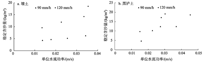
从表6可以看出,对于塿土和黑垆土坡面,均为γ单位水流功率最大,分别为0.6332和0.6160,说明单位水流功率是与稳定含沙量发展趋势最接近的因素。
在相同的单位水流功率条件下,大雨强条件下(120 mm/h)的稳定含沙量要高于小雨强条件下(90 mm/h)的稳定含沙量(图2),说明单位水流功率与稳定含沙量的关系受降雨强度影响(Arjmand Sajjadi et al, 2015)。原因在于,降雨对于坡面泥沙起动具有促进作用,雨强愈大,泥沙愈容易起动,此时被径流搬运的泥沙就相应增多(赵春红等, 2013)。Kinnell(2010)及Mahmoudabadi等(2011)的研究表明,雨滴动能对土壤颗粒的分离和输移具有重要作用,故在片蚀条件下单纯采用表征径流能量的单位水流功率指标并不足以表征稳定含沙量。
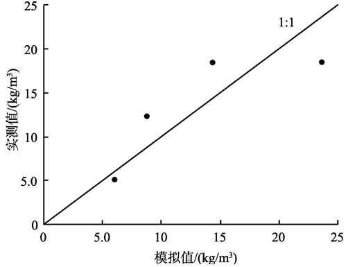
利用SPSS 19.0对3/4的稳定含沙量数据与土壤颗粒体积分形维数、降雨强度和单位水流功率进行逐步回归分析,结果如下:
式中:P为单位水流功率/(m/s);其他变量同式(9)。回归结果显示:降雨强度和单位水流功率均通过0.01的显著性水平检验,土壤颗粒体积分形维数也通过0.05的显著性水平检验。
采用1/4的稳定含沙量数据验证式(10)(图3),以Nash-Sutcliffe效率系数Ens和相对误差Re评价式(10)的有效性。Ens和Re越接近1和0,说明模拟效果越好。依据沈晔娜(2010)“Ens>0.5和Re<15%”的标准判别模型模拟效果,计算得知Ens和Re分别为0.527和-2.6%,说明式(10)有较好的模拟效果。且从式(10)可知,降雨强度对稳定含沙量的影响大于单位水流功率的影响。
图2 稳定含沙量与单位水流功率的关系
Fig.2 Relationships between steady sediment concentration and unit stream power
图3 稳定含沙量实测值和模拟值
Fig.3 Comparison between predicted and measured steady sediment concentrations
本试验条件下,黄土坡面在片蚀过程中,到一定降雨历时后,含沙量会达到稳定状态。
(1) 90 mm/h降雨强度下,坡度从10°增加到25°时,塿土坡面的稳定含沙量从4.30 kg/m3增至6.25 kg/m3,黑垆土坡面的稳定含沙量从4.76 kg/m3增至12.42 kg/m3;120 mm/h降雨强度下,坡度从10°增加到25°时,塿土坡面的稳定含沙量从9.56 kg/m3增至18.53 kg/m3,黑垆土坡面的稳定含沙量从9.72 kg/m3增至18.57 kg/m3。各因素对稳定含沙量的影响程度从大到小依次为土壤颗粒体积分形维数、降雨强度和坡度。
(2) 坡面侵蚀的动力源自降雨及其引起的地表径流,单位水流功率是与稳定含沙量发展趋势最接近的因素。对稳定含沙量的影响程度从大到小依次为土壤颗粒体积分形维数、降雨强度和单位水流功率。
溅蚀片蚀带是坡面侵蚀的最上方地带,研究其径流含沙量变化对阐明坡面侵蚀规律有重要意义。本文研究了片蚀过程径流含沙量的变化过程及稳定径流含沙量的影响因素。径流含沙量随降雨历时的增加呈非线性变化,因此降雨历时的长短会影响平均径流含沙量的大小;而稳定径流含沙量的大小则与降雨历时的长短无关,因此,研究片蚀过程的影响因素时可采用稳定径流含沙量。Shih和Yang(2009)研究认为,单位水流功率指标是影响径流含沙量变化的最优指标。本文认为在薄层径流条件下,降雨强度和单位水流功率均对稳定含沙量变化均有影响,且降雨强度的影响程度要大于单位水流功率。
The authors have declared that no competing interests exist.
| [1] |
黄土坡面片蚀水流含沙量变化过程试验研究 [J].
采用人工模拟降雨试验方法对黄 土坡面片蚀水流含沙量变化过程进行研究,结果表明:不同雨强和坡度条件下,片蚀水流含沙量变化过程均表现为先增大后减小,最终趋于相对稳定的趋势;片蚀水 流平均含沙量随雨强和坡度的增大而增大,分别可用幂函数方程和对数方程描述;雨强和坡度对片蚀水流含沙量的综合作用可用二元幂函数方程很好地描述,其中坡 度对坡面片蚀水流含沙量的影响大于雨强;单位水流功率是与片蚀水流含沙量变化过程关系最密切的水动力学参数,是坡面片蚀水流含沙量变化过程发生发展的动力 根源。
Experimental study on variation process of flow sedimsent concentration of sheet erosion of loess slope surface [J].
采用人工模拟降雨试验方法对黄 土坡面片蚀水流含沙量变化过程进行研究,结果表明:不同雨强和坡度条件下,片蚀水流含沙量变化过程均表现为先增大后减小,最终趋于相对稳定的趋势;片蚀水 流平均含沙量随雨强和坡度的增大而增大,分别可用幂函数方程和对数方程描述;雨强和坡度对片蚀水流含沙量的综合作用可用二元幂函数方程很好地描述,其中坡 度对坡面片蚀水流含沙量的影响大于雨强;单位水流功率是与片蚀水流含沙量变化过程关系最密切的水动力学参数,是坡面片蚀水流含沙量变化过程发生发展的动力 根源。
|
| [2] |
黄土高原土壤水分性质及其分区 [J].URL 摘要
黄土高原土壤具有很好的调节作物供水的功能,这和土壤的水分性质有关。本文研究了土壤的持水性能、有效性能和移动性能等。影响黄土高原土壤水分性质的主要因素是土壤质地。文内绘制了包括五个质地带的土壤质地分区图。田间持水量在轻壤土、中壤土和重壤土范围内均为20%±2,未表现出明显相关。萎蔫湿度则几乎完全决定于土壤质地。文内绘制了田间持水量和萎蔫湿度的等值线图。土壤水物理蒸发影响深度可达2-3米。两米土层内物理蒸发失水量轻壤土和中壤土达田间持水量的25-35%;具有下伏粘化层的重壤土,60厘米以下矢水量不大于10%。后者为作物准备了较多的储水。文内列出了不同质地土壤的水分特征曲线的经验方程,所有资料汇总于土壤水分性质表中。本研究结果为合理利用土地提供了基础数据。
Soil water properties and its zonation in the Loess Plateau [J].URL 摘要
黄土高原土壤具有很好的调节作物供水的功能,这和土壤的水分性质有关。本文研究了土壤的持水性能、有效性能和移动性能等。影响黄土高原土壤水分性质的主要因素是土壤质地。文内绘制了包括五个质地带的土壤质地分区图。田间持水量在轻壤土、中壤土和重壤土范围内均为20%±2,未表现出明显相关。萎蔫湿度则几乎完全决定于土壤质地。文内绘制了田间持水量和萎蔫湿度的等值线图。土壤水物理蒸发影响深度可达2-3米。两米土层内物理蒸发失水量轻壤土和中壤土达田间持水量的25-35%;具有下伏粘化层的重壤土,60厘米以下矢水量不大于10%。后者为作物准备了较多的储水。文内列出了不同质地土壤的水分特征曲线的经验方程,所有资料汇总于土壤水分性质表中。本研究结果为合理利用土地提供了基础数据。
|
| [3] |
|
| [4] |
黄土坡面片蚀过程试验研究 [J].URL 摘要
片蚀过程是坡面径流侵蚀过程的第一阶段和侵蚀方式演变的初始形态,阐明坡面片蚀过程可为坡面侵蚀过程模型建立和坡面水土流失治理提供重要科学依据。采用人工模拟降雨试验方法对黄土坡面片蚀过程进行了研究,结果表明:不同雨强及不同坡度下,坡面片蚀率皆随降雨历时的增长呈先急剧增大后趋于稳定的变化趋势,变化的转折点为产流后的5min左右;坡面片蚀模数随雨强和坡度的增大均呈显著的增加,可分别用指数方程和对数方程描述;雨强和坡度对片蚀模数的综合影响可以用二元幂函数方程描述,其中,坡度的影响大于雨强;水流功率是试验条件下与坡面片蚀动力学过程关系最密切的水动力学参数,坡面片蚀动力学过程的发生发展根源于坡面薄层径流的水流功率的动力作用。采取有关水保措施减低地面坡度,增加地面入渗,降低坡面径流流速可以有效地减少坡面片蚀。
Experimental study of sheet erosion processes on loess hillslope [J].URL 摘要
片蚀过程是坡面径流侵蚀过程的第一阶段和侵蚀方式演变的初始形态,阐明坡面片蚀过程可为坡面侵蚀过程模型建立和坡面水土流失治理提供重要科学依据。采用人工模拟降雨试验方法对黄土坡面片蚀过程进行了研究,结果表明:不同雨强及不同坡度下,坡面片蚀率皆随降雨历时的增长呈先急剧增大后趋于稳定的变化趋势,变化的转折点为产流后的5min左右;坡面片蚀模数随雨强和坡度的增大均呈显著的增加,可分别用指数方程和对数方程描述;雨强和坡度对片蚀模数的综合影响可以用二元幂函数方程描述,其中,坡度的影响大于雨强;水流功率是试验条件下与坡面片蚀动力学过程关系最密切的水动力学参数,坡面片蚀动力学过程的发生发展根源于坡面薄层径流的水流功率的动力作用。采取有关水保措施减低地面坡度,增加地面入渗,降低坡面径流流速可以有效地减少坡面片蚀。
|
| [5] |
黄土坡面片流产流过程模拟研究 [J].
采用模拟降雨试验方法对黄土坡面片流产流过程进行了试验研究,试验雨强分别为1.00、1.33、1.67、2.00、2.33mm min-1,坡度分别为9°、12°、15°、18°、21°。结果表明:1)不同雨强及不同坡度条件下,坡面片流径流率随降雨历时的变化均呈先增大后趋于稳定的趋势,不同雨强下较不同坡度下趋于稳定的时间早5min左右,变化过程皆可用对数方程y=aLn(x)+b描述;2)坡面片流径流深随雨强及坡度的变化皆可用幂函数方程H=al^b和H=aS^b描述;3)坡面片流径流深对坡度和雨强的综合响应可用二元幂函数方程H:3.83I^1.01 S^0.490描述,且雨强的影响大于坡度;4)黄土坡面片流产流的片蚀效应显著,不同雨强及不同坡度条件下片流产流的片蚀效应分别表现为幂函数方程M=0.0378H^1.21及线性方程M=0.235H-3.48。
Simulated-rainfall experimental study on runoff of sheet flow on loess hillslope [J].
采用模拟降雨试验方法对黄土坡面片流产流过程进行了试验研究,试验雨强分别为1.00、1.33、1.67、2.00、2.33mm min-1,坡度分别为9°、12°、15°、18°、21°。结果表明:1)不同雨强及不同坡度条件下,坡面片流径流率随降雨历时的变化均呈先增大后趋于稳定的趋势,不同雨强下较不同坡度下趋于稳定的时间早5min左右,变化过程皆可用对数方程y=aLn(x)+b描述;2)坡面片流径流深随雨强及坡度的变化皆可用幂函数方程H=al^b和H=aS^b描述;3)坡面片流径流深对坡度和雨强的综合响应可用二元幂函数方程H:3.83I^1.01 S^0.490描述,且雨强的影响大于坡度;4)黄土坡面片流产流的片蚀效应显著,不同雨强及不同坡度条件下片流产流的片蚀效应分别表现为幂函数方程M=0.0378H^1.21及线性方程M=0.235H-3.48。
|
| [6] |
黄土高原土壤侵蚀垂直分带性研究 [J].URL 摘要
土壤侵蚀垂直分带是黄土高原土壤侵蚀分布的重要规律。本文通过野外细沟、浅沟侵蚀实测,航片判读和量算,小区域调查与制图等方法,对黄土高原土壤侵蚀垂直分带作了系统研究和划分,并提出两个水土保持重点带。通过系统的测量发现了以往被忽视但很重要的一个侵蚀带:细沟、浅沟侵蚀过渡带。提出浅沟、切沟侵蚀混交带的新概念。本文对塬区与丘陵区分别进行研究与划分,补充了塬区分带研究这一薄弱环节,对黄土高原土壤侵蚀制图和水土保持措施布设具有指导意义.
A study on the vertical zoning of soil erosion in the Loess Plateau [J].URL 摘要
土壤侵蚀垂直分带是黄土高原土壤侵蚀分布的重要规律。本文通过野外细沟、浅沟侵蚀实测,航片判读和量算,小区域调查与制图等方法,对黄土高原土壤侵蚀垂直分带作了系统研究和划分,并提出两个水土保持重点带。通过系统的测量发现了以往被忽视但很重要的一个侵蚀带:细沟、浅沟侵蚀过渡带。提出浅沟、切沟侵蚀混交带的新概念。本文对塬区与丘陵区分别进行研究与划分,补充了塬区分带研究这一薄弱环节,对黄土高原土壤侵蚀制图和水土保持措施布设具有指导意义.
|
| [7] |
降雨侵蚀过程中黑土团聚体流失特征研究 [J].https://doi.org/10.5846/stxb201410282108 URL Magsci [本文引用: 1] 摘要
坡面侵蚀过程中土壤团聚体流失可直接反映土壤团聚体的破碎程度以及雨滴打击和径流搬运之间的相互作用。基于模拟降雨试验,研究降雨侵蚀过程中黑土坡面土壤团聚体流失特征。试验处理包括黑土区常见的2个侵蚀性降雨(50、100mm/h降雨强度)和2个坡度(5°和7.5°)以及2种地面处理(裸露休闲和秸秆覆盖)。结果表明:裸露休闲处理下径流含沙量是秸秆覆盖处理的27.5—141.3倍,且不同处理下含沙量最大值均出现在降雨初期。覆盖秸秆与无覆盖试验处理下土壤团聚体流失均以〈0.25mm微团聚体为主。秸秆覆盖试验处理下泥沙中〈0.25mm微团聚体流失量占团聚体流失总量的34.5%-56.8%,而在裸露休闲处理下其值达到82%以上。秸秆覆盖处理下的各粒级团聚体流失量较裸露休闲试验处理减少了33.3%以上,其中差异最明显的是≥1mm粒级团聚体与〈0.25mm微团聚体,二者分别较裸露休闲处理减少了43.1%-96.4%和99.0%以上。秸秆覆盖处理下的0.25—2mm粒级团聚体流失比例较裸露休闲处理明显增加。秸秆覆盖试验处理下流失团聚体的平均重量直径(MWD)和几何平均直径(GMD)分别是裸露休闲处理的1.5—2.9和1.7—2.0倍;而秸秆覆盖处理下的平均重量比表面积(MWSSA)和分形维数(D)较裸露休闲处理分别减少了26.2%-32.9%和5.1%-6.7%。
An experiment study of Mollisol arrregate loss characteristics during rainfall erosion processes [J].https://doi.org/10.5846/stxb201410282108 URL Magsci [本文引用: 1] 摘要
坡面侵蚀过程中土壤团聚体流失可直接反映土壤团聚体的破碎程度以及雨滴打击和径流搬运之间的相互作用。基于模拟降雨试验,研究降雨侵蚀过程中黑土坡面土壤团聚体流失特征。试验处理包括黑土区常见的2个侵蚀性降雨(50、100mm/h降雨强度)和2个坡度(5°和7.5°)以及2种地面处理(裸露休闲和秸秆覆盖)。结果表明:裸露休闲处理下径流含沙量是秸秆覆盖处理的27.5—141.3倍,且不同处理下含沙量最大值均出现在降雨初期。覆盖秸秆与无覆盖试验处理下土壤团聚体流失均以〈0.25mm微团聚体为主。秸秆覆盖试验处理下泥沙中〈0.25mm微团聚体流失量占团聚体流失总量的34.5%-56.8%,而在裸露休闲处理下其值达到82%以上。秸秆覆盖处理下的各粒级团聚体流失量较裸露休闲试验处理减少了33.3%以上,其中差异最明显的是≥1mm粒级团聚体与〈0.25mm微团聚体,二者分别较裸露休闲处理减少了43.1%-96.4%和99.0%以上。秸秆覆盖处理下的0.25—2mm粒级团聚体流失比例较裸露休闲处理明显增加。秸秆覆盖试验处理下流失团聚体的平均重量直径(MWD)和几何平均直径(GMD)分别是裸露休闲处理的1.5—2.9和1.7—2.0倍;而秸秆覆盖处理下的平均重量比表面积(MWSSA)和分形维数(D)较裸露休闲处理分别减少了26.2%-32.9%和5.1%-6.7%。
|
| [8] |
|
| [9] |
流域非点源污染过程动态模拟及其定量控制[D] .Modeling about non-point source pollution and quantity control for it within watershed[D]. |
| [10] |
土壤可蚀性动态变化机制与土壤可蚀性估算模型[D] .
Dynamic mechanism of soil erodibility and soil erodibility calculation model[D].
|
| [11] |
土壤颗粒的体积分形维数及其在土地利用中的应用 [J].https://doi.org/10.3321/j.issn:0564-3929.2005.04.003 URL [本文引用: 1] 摘要
土壤具有自相似特征或尺度不变特征。许多研究表明,土壤质量(重量)分形维数是土壤内在属性之一。但是,在计算土壤质量分形维数的推导过程中需要做一些假设,而有些假设,如不同粒级的土壤颗粒具有相同的密度等假设,已受到一些学者的批评。此外,用传统的比重法测量土壤颗粒分布不仅工作量大,且操作结果更易受人为因素的影响。鉴此,本文提出了土壤体积分形维数的概念。通过对宜兴不同土地利用方式下178个土壤样品的体积分形维数的测定发现:土壤体积分形维数和土壤质量分形维数一样,都是土壤的固有属性;土壤颗粒体积分形维数与土壤颗粒体积百分含量具有显著的对数相关关系;对茶园、菜地和农田土壤剖面上土壤颗粒体积分形维数的变化分析
Volume fractal dimension of soil particles and its applications to land use [J].https://doi.org/10.3321/j.issn:0564-3929.2005.04.003 URL [本文引用: 1] 摘要
土壤具有自相似特征或尺度不变特征。许多研究表明,土壤质量(重量)分形维数是土壤内在属性之一。但是,在计算土壤质量分形维数的推导过程中需要做一些假设,而有些假设,如不同粒级的土壤颗粒具有相同的密度等假设,已受到一些学者的批评。此外,用传统的比重法测量土壤颗粒分布不仅工作量大,且操作结果更易受人为因素的影响。鉴此,本文提出了土壤体积分形维数的概念。通过对宜兴不同土地利用方式下178个土壤样品的体积分形维数的测定发现:土壤体积分形维数和土壤质量分形维数一样,都是土壤的固有属性;土壤颗粒体积分形维数与土壤颗粒体积百分含量具有显著的对数相关关系;对茶园、菜地和农田土壤剖面上土壤颗粒体积分形维数的变化分析
|
| [12] |
|
| [13] |
激光衍射法测定土壤质地的方法及其在土壤结构研究中的应用[D] .
The method to measure soil texture by laser diffraction and its application on soil structure [D].
|
| [14] |
雨滴击溅在薄层水流侵蚀中的作用 [J].URL 摘要
试验采用人工模拟降雨方法,对薄层水流侵蚀的两个阶段——雨滴击溅及径流侵蚀进行了模拟试验研究。得出:在消除雨滴打击作用后,坡面侵蚀的主要营力为薄层水流的拖拽力(τ=rhsinα),且径流侵蚀量S_R与τ有下列关系式: S_R=921.497τ~(1.713) r=0.876 α=0.017 以上式为基础,即可从有雨滴打击作用下所产生的侵蚀量中推算出径流侵蚀量S_R与雨滴侵蚀量S_(Rd)。结果表明:S_(Rd)一般占总侵蚀量的70%以上,最高可达95%,说明薄层水流侵蚀所产生的泥沙绝大部分是由雨滴击溅所致。因此,笔者认为坡度较小地段的薄层水流侵蚀,应以消除或降低雨滴击溅作用为其主要防治措施。
The action of raindrop splash on sheet flow erosion [J].URL 摘要
试验采用人工模拟降雨方法,对薄层水流侵蚀的两个阶段——雨滴击溅及径流侵蚀进行了模拟试验研究。得出:在消除雨滴打击作用后,坡面侵蚀的主要营力为薄层水流的拖拽力(τ=rhsinα),且径流侵蚀量S_R与τ有下列关系式: S_R=921.497τ~(1.713) r=0.876 α=0.017 以上式为基础,即可从有雨滴打击作用下所产生的侵蚀量中推算出径流侵蚀量S_R与雨滴侵蚀量S_(Rd)。结果表明:S_(Rd)一般占总侵蚀量的70%以上,最高可达95%,说明薄层水流侵蚀所产生的泥沙绝大部分是由雨滴击溅所致。因此,笔者认为坡度较小地段的薄层水流侵蚀,应以消除或降低雨滴击溅作用为其主要防治措施。
|
| [15] |
雨滴击溅对薄层水流水力摩阻系数的影响 [J].
采用模拟降雨的试验方法,在分析计算有无雨滴击溅作用坡面薄层水流水力摩阻系数的基础上,进一步分析了雨滴击溅作用对薄层水流水力摩阻系数的影响。结果表明,雨滴击溅作用可减少薄层水流的水力摩阻系数,从而减少水流摩擦阻力,使水流侵蚀力相对增大;有雨滴击溅作用时其水力摩阻系数平均为无雨滴击溅时的66.14%。这说明雨滴的击溅除了本身的分散和破坏土壤结构等侵蚀作用外,还可降低水流的水力摩阻系数,从而增加径流的冲刷力。
The effects of raindrop splash on the sheet flow hydraulic friction factor [J].
采用模拟降雨的试验方法,在分析计算有无雨滴击溅作用坡面薄层水流水力摩阻系数的基础上,进一步分析了雨滴击溅作用对薄层水流水力摩阻系数的影响。结果表明,雨滴击溅作用可减少薄层水流的水力摩阻系数,从而减少水流摩擦阻力,使水流侵蚀力相对增大;有雨滴击溅作用时其水力摩阻系数平均为无雨滴击溅时的66.14%。这说明雨滴的击溅除了本身的分散和破坏土壤结构等侵蚀作用外,还可降低水流的水力摩阻系数,从而增加径流的冲刷力。
|
| [16] |
基于双土槽试验研究的黄土坡面侵蚀产沙过程 [J].https://doi.org/10.3969/j.issn.1672-3007.2003.04.003 URL Magsci 摘要
定量分析梁峁坡面各侵蚀带之间侵蚀过程中的相互作用及其影响机 理,将为坡面侵蚀预报模型的建立提供重要的理论基础.利用供沙土槽和试验土槽双土槽径流小区,研究不同上方汇流含沙量、不同降雨强度和不同地表面条件下的 黏黄土陡坡面(15°)上方汇流汇沙,对坡下方侵蚀产沙过程的影响.研究结果表明:上方汇流汇沙对坡面侵蚀产沙过程有重要影响,上方来沙不但被径流全部搬 运,而且上方来水在试验土槽引起了净侵蚀产沙量,坡面侵蚀现象为侵蚀-搬运过程占主导地位.对于疏松土和紧实土处理,上方汇流引起坡下方的净侵蚀产沙量, 分别占试验土槽全部产沙量的31.1%~97.3%和45.1%~89.7%.上方汇流引起坡下方净侵蚀产沙量随降雨强度的增加而增加,同时受土壤容重和 下垫面细沟侵蚀发展过程的综合影响.土壤容重影响坡面侵蚀的发生和发展,而坡面侵蚀产沙过程与细沟发育过程相对应.
Loess hill slope erosion and sediment yield process using a dual box system [J].https://doi.org/10.3969/j.issn.1672-3007.2003.04.003 URL Magsci 摘要
定量分析梁峁坡面各侵蚀带之间侵蚀过程中的相互作用及其影响机 理,将为坡面侵蚀预报模型的建立提供重要的理论基础.利用供沙土槽和试验土槽双土槽径流小区,研究不同上方汇流含沙量、不同降雨强度和不同地表面条件下的 黏黄土陡坡面(15°)上方汇流汇沙,对坡下方侵蚀产沙过程的影响.研究结果表明:上方汇流汇沙对坡面侵蚀产沙过程有重要影响,上方来沙不但被径流全部搬 运,而且上方来水在试验土槽引起了净侵蚀产沙量,坡面侵蚀现象为侵蚀-搬运过程占主导地位.对于疏松土和紧实土处理,上方汇流引起坡下方的净侵蚀产沙量, 分别占试验土槽全部产沙量的31.1%~97.3%和45.1%~89.7%.上方汇流引起坡下方净侵蚀产沙量随降雨强度的增加而增加,同时受土壤容重和 下垫面细沟侵蚀发展过程的综合影响.土壤容重影响坡面侵蚀的发生和发展,而坡面侵蚀产沙过程与细沟发育过程相对应.
|
| [17] |
槽式人工模拟降雨机的工作原理与特性 [J].https://doi.org/10.3969/j.issn.1000-288X.2007.06.013 URL 摘要
利用人工模拟降雨,可以进行各 种下垫面条件下土壤侵蚀与水土保持实验研究,大大缩短了试验研究周期,已成为室内与野外试验的重要技术手段,是获取土壤侵蚀、水土保持效益、土壤侵蚀模型 等相关研究数据的有效途径。在详细论述人工模拟降雨机的基本要求和类型的基础上,重点论述了槽式人工模拟降雨机的结构、工作原理及其优缺点,旨在促进我国 人工模拟降雨机研制的步伐,为土壤侵蚀与水土保持相关实验研究提供参考。
Principles and properties of artificial trough rainfall simulator [J].https://doi.org/10.3969/j.issn.1000-288X.2007.06.013 URL 摘要
利用人工模拟降雨,可以进行各 种下垫面条件下土壤侵蚀与水土保持实验研究,大大缩短了试验研究周期,已成为室内与野外试验的重要技术手段,是获取土壤侵蚀、水土保持效益、土壤侵蚀模型 等相关研究数据的有效途径。在详细论述人工模拟降雨机的基本要求和类型的基础上,重点论述了槽式人工模拟降雨机的结构、工作原理及其优缺点,旨在促进我国 人工模拟降雨机研制的步伐,为土壤侵蚀与水土保持相关实验研究提供参考。
|
| [18] |
含沙量对坡面流水动力学特性的影响研究 [J].https://doi.org/10.6041/j.issn.1000-1298.2013.09.015 URL 摘要
基于系列室内水槽冲刷试验,定量研究了在9°坡度、不同流量条件 下含沙量对坡面流水动力学参数的影响.结果表明:随含沙量增加,水流雷诺数Re减小,水流紊动强度减弱.弗劳德数、水流流速及流速修正系数α随含沙量增加 先呈减小趋势,当含沙量S> 300 kg/m3时,各值均突然增大,并随含沙量的进一步增加趋于稳定,表明此时水流型态发生变化,a均值为0.554.含沙水流和清水水流能量损失比较标准不 同,得到的结论也不相同.当S< 300 kg/m3时,以相同Re或相同单宽流量作为比较标准,含沙水流阻力系数均大于清水对应值;当S>300 kg/m3时,以相同的Re作为比较标准,则含沙水流阻力系数小于清水对应值,以相同的单宽流量作为比较标准,则含沙水流阻力系数大于清水对应值.
Effects of sediment load on hydrodynamic characteristics of overland flow [J].https://doi.org/10.6041/j.issn.1000-1298.2013.09.015 URL 摘要
基于系列室内水槽冲刷试验,定量研究了在9°坡度、不同流量条件 下含沙量对坡面流水动力学参数的影响.结果表明:随含沙量增加,水流雷诺数Re减小,水流紊动强度减弱.弗劳德数、水流流速及流速修正系数α随含沙量增加 先呈减小趋势,当含沙量S> 300 kg/m3时,各值均突然增大,并随含沙量的进一步增加趋于稳定,表明此时水流型态发生变化,a均值为0.554.含沙水流和清水水流能量损失比较标准不 同,得到的结论也不相同.当S< 300 kg/m3时,以相同Re或相同单宽流量作为比较标准,含沙水流阻力系数均大于清水对应值;当S>300 kg/m3时,以相同的Re作为比较标准,则含沙水流阻力系数小于清水对应值,以相同的单宽流量作为比较标准,则含沙水流阻力系数大于清水对应值.
|
| [19] |
不同坡度下紫色土地表微地形变化及其对土壤侵蚀的影响 [J].https://doi.org/10.3969/j.issn.1002-6819.2015.08.025 URL Magsci [本文引用: 1] 摘要
为了揭示川中丘陵区紫色土地表微地形变化对土壤侵蚀的影响,该文通过室内人工模拟降雨试验,从地表糙度角度出发,结合多重分形理论与方法,分析了不同坡度条件下紫色土地表微地形变化特征,探讨了地表微地形变化与土壤侵蚀间的关系。结果表明:1)雨强为1.5 mm/min,历时为40 min降雨条件下,10°、15°和20°坡面地表相对高程的变化量分别为-11.66、-3.52和-5.61 mm,仅20°坡面地表初始低洼部位被径流贯通形成细沟;各坡面地表糙度均有所减小,且表现为15°10°20°,其中10°和15°坡面不同坡位地表糙度均较雨前减小,20°坡面下坡地表糙度较雨前增大,不同坡度全坡面地表糙度均较雨前减小;2)地表微地形具有一定的多重分形特征,10°和15°坡面雨后多重分形参数广义分形维数跨度、奇异指数跨度和多重分形谱高差均较雨前增大,微地形空间分布差异增大,且地表变得圆润,20°坡面与之相反;3)随坡度增大,地表径流量呈先减小后增大的变化趋势,且地表糙度变幅越小的坡面,地表产流量越高,而侵蚀产沙量则随坡度的增大显著提高(P0.05)。研究成果为揭示水蚀过程中地表微地形变化的本质和作用机理提供了参考。
Changes in soil surface micro-relief of purple soil under different slope gradients and its effects on soil erosion [J].https://doi.org/10.3969/j.issn.1002-6819.2015.08.025 URL Magsci [本文引用: 1] 摘要
为了揭示川中丘陵区紫色土地表微地形变化对土壤侵蚀的影响,该文通过室内人工模拟降雨试验,从地表糙度角度出发,结合多重分形理论与方法,分析了不同坡度条件下紫色土地表微地形变化特征,探讨了地表微地形变化与土壤侵蚀间的关系。结果表明:1)雨强为1.5 mm/min,历时为40 min降雨条件下,10°、15°和20°坡面地表相对高程的变化量分别为-11.66、-3.52和-5.61 mm,仅20°坡面地表初始低洼部位被径流贯通形成细沟;各坡面地表糙度均有所减小,且表现为15°10°20°,其中10°和15°坡面不同坡位地表糙度均较雨前减小,20°坡面下坡地表糙度较雨前增大,不同坡度全坡面地表糙度均较雨前减小;2)地表微地形具有一定的多重分形特征,10°和15°坡面雨后多重分形参数广义分形维数跨度、奇异指数跨度和多重分形谱高差均较雨前增大,微地形空间分布差异增大,且地表变得圆润,20°坡面与之相反;3)随坡度增大,地表径流量呈先减小后增大的变化趋势,且地表糙度变幅越小的坡面,地表产流量越高,而侵蚀产沙量则随坡度的增大显著提高(P0.05)。研究成果为揭示水蚀过程中地表微地形变化的本质和作用机理提供了参考。
|
| [20] |
|
| [21] |
黄土高原土壤侵蚀暴雨标准 [J].
暴雨是引起黄土高原土壤侵蚀的一个关键的、起动力作用的因子。黄土高原严重的土壤侵蚀往往是由少数几次暴雨引起,因此,研究黄土高原的暴雨标准,进而制定暴雨分区,对黄土高原水土保持规划工作具有重大意义。黄土高原的暴雨标准,过去虽曾有人拟定过几种,但主要是针对防洪等工作拟定的,从土壤侵蚀的角度考虑的不够,所以不能完全适应水土保持工作的需要。本试验通过人工模拟降雨的方法,拟定了黄土高原针对土壤侵蚀的暴雨标准,即土壤侵蚀暴雨标准。初步确定,能使坡面上开始产生径流的降雨为暴雨,其中又以能使坡面上开始产生细沟侵蚀为标准,划分出普通暴雨及大暴雨。试验在20°无植被覆盖的均一黄土母质小区(面积为5×1.5=7.5平方米)上,用侧喷式人工模拟降雨装置进行。通过对试验结果的统计分析和能量换算,拟定出黄土高原天然降雨的土壤侵蚀暴雨标准(表4)。
Soil erosion storm rainfall standard in the Loess Plateau [J].
暴雨是引起黄土高原土壤侵蚀的一个关键的、起动力作用的因子。黄土高原严重的土壤侵蚀往往是由少数几次暴雨引起,因此,研究黄土高原的暴雨标准,进而制定暴雨分区,对黄土高原水土保持规划工作具有重大意义。黄土高原的暴雨标准,过去虽曾有人拟定过几种,但主要是针对防洪等工作拟定的,从土壤侵蚀的角度考虑的不够,所以不能完全适应水土保持工作的需要。本试验通过人工模拟降雨的方法,拟定了黄土高原针对土壤侵蚀的暴雨标准,即土壤侵蚀暴雨标准。初步确定,能使坡面上开始产生径流的降雨为暴雨,其中又以能使坡面上开始产生细沟侵蚀为标准,划分出普通暴雨及大暴雨。试验在20°无植被覆盖的均一黄土母质小区(面积为5×1.5=7.5平方米)上,用侧喷式人工模拟降雨装置进行。通过对试验结果的统计分析和能量换算,拟定出黄土高原天然降雨的土壤侵蚀暴雨标准(表4)。
|
| [22] |
Methodologies for interrill soil erosion studies [J].https://doi.org/10.1016/S0167-1987(98)00182-2 URL 摘要
Due to wide range of experimental techniques reported in the literature for determining interrill erodibility and soil loss values, meaningful comparisons between experiments often cannot be made. Furthermore, inaccurate concepts are developed because erosion processes are dependent upon methodologies. The purpose of this paper is to discuss problems related to both laboratory and field rainfall simulator experiments. Rainfall simulators cannot duplicate a wide range of rainfall intensities and, at the same time, have similar energies as natural rainstorms, unless several different nozzles are used. Rainfall intensity in most simulators is created by varying the frequency of spray oscillation. This intermittent spray characteristic of most simulators, and the constant drop size characteristic of other simulators, greatly affects results. Erosion pan design for laboratory studies and preparation of soil samples placed in the pans also can influence erosion results. We conclude that standardization of rainfall simulator design and test procedures will allow better comparison of erosion results to be made among researchers.
|
| [23] |
Sediment concentration and hydraulic characteristics of rain-induced overland flows in arid land soils [J].https://doi.org/10.1007/s11368-015-1072-z URL [本文引用: 1] 摘要
Purpose Rain-induced overland flow involves the detachment of soil particles by raindrop impact and the transportation by the resultant overland flow. The purpose of this study was to
|
| [24] |
Interrill soil erosion processes and their interaction on low slopes [J].https://doi.org/10.1002/esp.1426 URL [本文引用: 1] 摘要
Not Available
|
| [25] |
Effects of rainfall intensity and slope gradient on the dynamics of interrill erosion during soil surface sealing [J].https://doi.org/10.1016/j.catena.2006.02.005 URL Magsci [本文引用: 1] 摘要
Soil erosion during rainfall is strongly affected by runoff and slope steepness. Runoff production is drastically increased when a seal is formed at the soil surface during rainfall. Therefore, a complex interaction exists between soil erosion and surface sealing. In this study, the dynamics of interrill erosion during seal formation is studied under different simulated rainfall and slope conditions. A sandy soil was exposed to 7002mm of rainfall at two intensities, 2402mm h 61021 and 6002mm h 61021 , and five slope gradients, from 5% to 25%. Infiltration, runoff and soil loss rates were monitored during rainfall. Final infiltration rates increased with slope gradient at both rainfall intensities, this effect being stronger for the higher intensity. Cumulative runoff at the end of the rainfall event was lower as slopes were steeper, while an opposite trend was obtained for soil loss. For the 5% and the 9% slopes, the sediment concentration in runoff reached quickly a stable value during the whole rainfall event, while it reached a peak value before declining for the higher slopes. The peak value and its timing were rainfall intensity dependent. Soil erodibility during seal formation was evaluated using two empirical multiplication-of-factors type models. It seems that slope and rainfall erosivity are accounted for only partly in these models. For mild slope gradients below 9%, the value of K i estimated by means of the two expressions becomes practically constant shortly after runoff apparition. Consequently, the estimates resulting from this type of expressions remain valuable from the practical point of view.
|
| [26] |
An approach to the sediment transport problem from general physics [M]. |
| [27] |
The interrill erosion for a sandy loam soil [J].https://doi.org/10.1016/S1001-6279(13)60043-8 URL Magsci [本文引用: 1] 摘要
This paper resumes a laboratory experience on a slope adjustable plot with the aim of examining the role of rainfall intensity and slope gradient for a sandy loam soil,typical of Southern Italy,with particular initial moisture content.The results of the simulations performed show that a rainfall reduction causes a corresponding percentage reduction of sediment output.A similar behaviour can be attributed to slope gradient,while runoff moderately increases with rainfall intensity but it is not sensitive to slope gradient.Data also highlight that the degree of saturation can affect runoff and soil loss values.
|
| [28] |
LISEM: A single-event physically based hydrological and soil erosion model for drainage basins: I. Theory, input and output [J]. |
| [29] |
A laboratory study of rill hydraulics:Ⅱ. Shear stress relationships [J].https://doi.org/10.13031/2013.32874 URL [本文引用: 1] |
| [30] |
An erosion equation derived from basic erosion principles [J].https://doi.org/10.13031/2013.35627 URL 摘要
AN erosion equation is derived from the continuity equation for sediment transport and other equa-tions describing rill and interrill erosion. The resulting equation is a useful model for explaining the behavior of the erosion process. The equation might serve as the basis for an operational equation for estimating soil loss for specific storms.
|
| [31] |
The relationship of soil loss by interrill erosion to slope gradient [J].https://doi.org/10.1109/TIFS.2013.2263499 URL [本文引用: 1] 摘要
The influence of slope gradient on erosion rate differs for rill and interrill conditions. Rill erosion increases substantially more with increasing slope gradient than interrill erosion. Combining the two erosion processes into single data sets led to the development of regression equations (e.g., USLE) that overestimated the effect of slope gradient on erosion rate for low slope gradients and short slopes. This study investigated the change in interrill erosion rate with slope gradient and examined its relationship to runoff velocity. A sandy loam (grey brown luvisol) was packed in 100脳40脳10 cm 3 soil trays and subjected to simulated rainfall for a period of 75 min. Rain-impacted flow erosion and downslope splash were monitored, and runoff velocity measurements were made at three positions within the flume. Downslope splash erosion never accounted for more than 20% of the total erosion. Rain-impacted flow erosion peaked early in the simulation then decreased to a constant rate; erosion rate was therefore probably detachment-limited. For a constant runoff rate, rain-impacted flow erosion increased roughly with the square root of slope gradient, as did the runoff velocity. Soil loss was correlated (0.81) with runoff velocity under the experimental conditions.
|
| [32] |
Sediment detachment by rain power [J].https://doi.org/10.1029/2001WR000656 URL [本文引用: 1] 摘要
In interrill areas, overland flow is often incapable of detaching soil particles so detachment is primarily by raindrop impact. We derive a mathematical expression, rain power (R, W m612), relating the energy expenditure of raindrops impacting a soil surface to the rate of detachment of soil particles. Rain power incorporates rainfall, hillslope, and vegetation characteristics and is modulated by flow depths. Rainfall simulation experiments on natural hillslopes were performed to measure detachment rates and across-slope flow depth distributions in surface runoff. Our results indicate that flow depths follow a Poisson distribution, and this observation is used to develop a dimensionless function, A(equation image, d), that accounts for the interaction of flow depths (h) and raindrop diameter (d) in moderating detachment rates. Rain power correlates well with the detachment rate of fine-grained particles (ψ, g m612 s611) so that ψ = 0.011R1.4A(equation image, d) (n = 44, R2 = 0.88, p < 0.005). We generalize this result to represent natural rainfall conditions and present a method for modeling sediment detachment rates and sediment discharge along entire lengths of hillslopes under the range of conditions where detached sediment is transported as wash load. Modeling simulations demonstrate the temporal and spatial variation in detachment rates caused by increases in flow depth.
|
| [33] |
Relationship between discharge, velocity and flow area for rills eroding loose, non-layered materials [J].https://doi.org/10.1002/esp.3290170510 URL [本文引用: 1] 摘要
A relationship between discharge, flow velocity and flow area in rills is established using data from four field and laboratory studies. The proposed relationship is shown to predict successfully flow velocities measured in six other studies. Although slopes range from 0.035 to 0.45 and soil materials range from stony sands over silt loams to vertisols, mean flow velocity can be well predicted from discharge alone. Thus, there is no important influence of slope and/or soil material characteristics on flow velocities in rills. The proposed relationship may be used to improve performance of deterministic flow routing models when applied to rilled catchments. Furthermore, it allows the calculation of unit stream power, which has been shown to be related to the transporting capacity of overland flow, in terms of slope and discharge.
|
| [34] |
The impact of slope length on the discharge of sediment by rain impact induced saltation and suspension [J].https://doi.org/10.1002/esp.1828 URL [本文引用: 1] 摘要
Abstract Simulations using a mechanistic model of raindrop driven erosion in rain-impacted flow were performed with particles travelling by suspension, raindrop induced saltation and flow driven saltation. Results generated by both a high intensity storm, and a less intense one, indicate that, because of the effect of flow depth on the delivery of raindrop energy to the bed, there is a decline in sediment concentration, and hence soil loss per unit area, with slope length when particles are transported by raindrop induced saltation. However, that decline is reversed when the critical velocities that lead to flow driven saltation are episodically exceeded during an event. The simulations were performed on smooth surfaces and a single drop size but the general relationships are likely to apply for rain made up of a wide range of drop size. Although runoff is not always produced uniformly, as a general rule, flow velocities increase with slope length so that, typically, the distance particles travel before being discharged during an event increase with slope length. The effect of slope length on soil loss per unit area is often considered to vary with slope length to a power greater than zero and less that 1路0. The simulations show that effect of slope length on sediment discharge is highly dependent on the variations in runoff response resulting from variations in rainfall duration-intensity-infiltration conditions rather than plot length per se . Consequently, predicting soil loss per unit area using slope length with positive powers close to zero when sheet erosion occurs may not be as effective as commonly expected. Erosion by rain-impacted flow is a complex process and that complexity needs to be considered when analysing the results of experiments associated with rain-impacted flow under both natural and artificial conditions. Copyright 漏 2009 John Wiley & Sons, Ltd.
|
| [35] |
Comment on a new splash and sheet erosion equation for range lands [J].https://doi.org/10.2136/sssaj2009.0265l URL 摘要
rate and rainfall rate in their data in their Fig. 4. That figure is reproduced here as Fig. 1.Despite the significant correlation coefficients produced by Eq. [7], the approach adopted by Wei et al. fails to deal with the fact that six different plots are involved at locations such as B190, and that spatial variation in plot characteristics resulted in plots that were not good replicates of each other. The excess rainfall rate is given by the difference between I and the infiltrations rate (Is). When the runoff rate reaches a steady value, as in the experiments being considered, Is is steady and the time of concentration of runoff has been reached so that the runoff rate is given by
|
| [36] |
The impact of natural polymer derivatives on sheet erosion on experimental loess hillslope [J].https://doi.org/10.1016/j.still.2014.01.004 URL 摘要
Macromolecular polymers can effectively improve soil structure, increase soil penetration and control runoff and erosion on hillslopes. Simulated rainfall experiments on a bare soil investigated the impact of natural polymer derivatives (NPD) on soil properties and the characteristics of runoff and sediment yield of sheet erosion on experimental loessial hillslopes. A control (without NPD) and three concentrations of polymers (1, 3 and 5 g/m
|
| [37] |
Study on process changes in some indices of soil erodibility and depositability using rainfall simulator [J].URL 摘要
Susceptibility of soil to rain-induced erosion processes is assumed as detachability and re-detachability parameters. In some conditions, generated overland flow can entrain and transport soil particles therefore, effects on the erodibility results. This study was conducted to investigate the effect of process changes in rain- induced erosion experiments on these parameters using four scenarios. Different rain intensities and flume slopes were simulated by a rainfall simulator on 3 cropland soils. The results showed that including stream powers less than the critical values and considering steady state conditions, the re-detachability was 100-212 order of magnitude of the detachability, while considering all stream powers, this ratio was from 62 to 122. Depending on the soil properties, there are some differences between two conditions of steady and unsteady. Compared to the former status, taking into account all stream powers, detachability and re-detachability parameters were over calculated 2-4 and 1.2-2.5 times, respectively. This finding reveals the importance of experimental design on determination of succeptibilty to rain-induced erosion
|
| [38] |
Application and sensitivity analysis of process-based erosion model GUEST [J].https://doi.org/10.1111/j.1365-2389.1996.tb01858.x URL 摘要
Summary As long-term measurement of erosion is expensive, models are required to predict spatial and temporal variation in erosion accurately for various land uses and to develop suitable practices for soil conservation. Details of the steady-state, process-based erosion model GUEST are presented with emphasis on the behaviour and sensitivity of the model to a fundamental erodibility parameter The model is developed to interpret temporal fluctuation in sediment concentration from bare soil in single erosion events. It incorporates the simultaneous effects of rainfall and runoff and of deposition on sediment concentration. An example of its application to temporal variation in sediment concentration for varying slopes and soil strengths show reasonable agreement between the measured data and the limits of sediment concentration predicted by the model. Sensitivity analysis indicated the model to be most sensitive to land slope and a defined sediment characteristic called depositability, but not as sensitive to frequency and dimensions of rills.
|
| [39] |
The European Soil Erosion Model (EUROSEM): A dynamic approach for predicting sediment transport from fields and small catchments [J].https://doi.org/10.1002/(SICI)1096-9837(199806)23:6<527::AID-ESP868>3.0.CO;2-5 URL 摘要
Not Available
|
| [40] |
Estimating overland flow erosion capacity using unit stream power [J].https://doi.org/10.1016/S1001-6279(09)60015-9 URL Magsci [本文引用: 1] 摘要
Soil erosion caused by water flow is a complex problem. Both empirical and physically based approaches were used for the estimation of surface erosion rates. Their applications are mainly limited to experimental areas or laboratory studies. The maximum sediment concentration overland flow can carry is not considered in most of the existing surface erosion models. The lack of erosion capacity limitation may cause over estimations of sediment concentration. A correlation analysis is used in this study to determine significant factors that impact surface erosion capacity. The result shows that the unit stream power is the most dominant factor for overland flow erosion which is consistent with experimental data. A bounded regression formula is used to reflect the limits that sediment concentration cannot be less than zero nor greater than a maximum value. The coefficients used in the model are calibrated using published laboratory data. The computed results agree with laboratory data very well. A one dimensional overland flow diffusive wave model is used in conjunction with the developed soil erosion equation to simulate field experimental results. This study concludes that the non-linear regression method using unit stream power as the dominant factor performs well for estimating overland flow erosion capacity.
|
| [41] |
Incipient motion and sediment transport [J].URL 摘要
A review of existing literature reveals some disadvantages of using Shields diagram as the criterion for incipient motion of sediment particles on an alluvial bed. A new criterion based on average flow velocity, fall velocity, and shear velocity Reynolds number is proposed herein with the supporting data collected by different investigators. This new criterion is used to calculate the dimensionless critical unit stream power in a dimensionless unit stream power equation for sediment transport. The dimensionless unit stream power is the ratio of the time rate of potential energy expenditure per unit weight of water and the terminal fall velocity of the sediment. More than 1,000 sets of data from both laboratory flumes and natural streams published by different authors are used to support this dimensionless equation for sediment transport.
|
| [42] |
Relationship between soil structure and runoff/soil loss after 24 years of conservation tillage [J].https://doi.org/10.1016/j.still.2006.01.006 URL [本文引用: 1] 摘要
A better understanding of tillage and stubble management effects on surface soil structure is vital for the development of effective soil conservation practices for the long-term. Relationships between aspects of soil structure and runoff/soil loss were investigated in 24 year old field experiment on an Oxic Paleustalf, in NSW, Australia. Two tillage/stubble management systems were compared, namely direct drilled/stubble retained (DD/SR) versus conventional tillage/stubble burnt (CC/SB). Tillage and stubble burning significantly increased bulk density and decreased the macro-aggregate stability, mean weight diameter (MWD), geometric mean diameter (GMD) and total porosity, particularly macroporosity (>60μm). For the 0–5cm layer, DD/SR had significantly higher water stability of macro-aggregates >2mm than CC/SB (165g/kg versus 78g/kg), and the volume of pore space of diameter >60μm at 0–5cm depth was significantly greater (more than 11%) for DD/SR than for CC/SB. Under simulated rainfall (100mm/h) and the removal of surface stubble, both runoff and soil loss were significantly higher under CC/SB compared to DD/SR. The infiltration rate at the end of the experiment under DD/SR was 3.7 times that of CC/SB (85mm/h versus 23mm/h). There were significant correlations between the proportion of soil particles >0.25mm measured after wetting by rain and both final infiltration rate ( P <0.001) and soil loss ( P <0.001). It was concluded that 24 years of direct drilling and stubble retained practices significantly reduced runoff and soil erosion hazards, due to a fundamental change in soil structure, viz. higher soil aggregate stability and higher macroporosity of the surface soil.
|
| [43] |
Modeling interrill sediment delivery [J].https://doi.org/10.2136/sssaj1998.03615995006200020021x URL [本文引用: 1] 摘要
ABSTRACT Shallow surface runoff is a primary transport agent for interrill sediment delivery. Runoff, rainfall intensity, and slope interactively affect interrill erosion. We hypothesized that the inclusion of a runoff factor in an interrill erosion model can reduce the dependence of the interrill soil erodibility (K(i)) on soil infiltration characteristics as well as improve model predictability. A complete factorial rainfall simulation experiment with two soils (Cecil sandy loam, a clayey, kaolinitic, thermic Typic Kanhapludult, and Dyke clay, a clayey, mixed, mesic Typic Rhodudult), four rainfall intensities, four slopes, and two replicates was conducted under prewetted conditions to measure runoff and sediment delivery rates. Tap water with electrical conductivity <0.2 dS m-1 was used in all the runs. Rainfall intensity I, unit discharge q, slope S, soil type, and their interactions significantly affected sediment delivery per unit area (D(i)). Sediment delivery had the greatest correlation (r = 0.68) with unit discharge; however, neither discharge nor rainfall alone adequately predicted sediment delivery. The equation D(i) = K(i)Iq1/2S2/3 was proposed. The linear intensity term (I) represents detachment of soil by raindrop impact and enhancement of transport capacity of sheet flow, while the product of q1/2S2/3 describes sediment transport by sheet flow. Validation with independent data showed that the model predicted soil erodibilities well. The mean r2 for four validation soils was 0.93 when the proposed model was filled to validation data to predict interrill erodibility (K(i)). The better estimation of K(i) indicates that interrill erosion processes were adequately described by the model.
|

/
| 〈 |
|
〉 |